What's new

China Expressways, Highways: News & Discussions

New expressway to open
Yanhe to Dejiang expressway documentary
located in NE Guizhou Province, Southwest China


Although it is not very long, this expressway includes many high bridges such as:

Wujiang Bridge Yanhe
乌江河大桥
(502) feet high / (153) meters high
(656) foot span / (200) meter span
2016
750px-Wujiang乌江河大桥NortheastGuizhou.jpg


Matihe Bridge
马蹄河特大桥
574 feet high / 175 meters high
591 foot span / 180 meter span
2016
750px-Matihe20150402.jpg


Guanlin Bridge
官林特大桥
(410) feet high / (125) meters high
427 foot span / 130 meter span
2016
750px-Guanlin70+130+70mtrs.jpg
750px-GuanlinWideView.jpg
 
Beijing’s new highway network connects urban zone twice the size of New York

Opening of 1,000km ring allows people from neighbouring Tianjin and Hebei to reach Beijing within an hour

PUBLISHED : Thursday, 08 December, 2016, 8:34am
UPDATED : Thursday, 08 December, 2016, 10:14am


3bc5708a-bc78-11e6-b1a9-d0a597083a8f_1280x720.JPG


Another ring of highways that extends 1,000km has been built around Beijing, becoming the seventh ring road and completing a key infrastructure project that closely connects the capital with neighbouring Tianjin and Hebei.

Completion of the ring makes it possible for residents of Hebei and Tianjin to travel to Beijing by road within an hour and is expected to foster satellite communities half an hour away. This would create a sprawling urban zone of 270,000 sq km, dwarfing Tokyo, at 35,000 sq km, and New York, at 138,000 sq km.

Cai Jianming, a professor with the Department of Urban and Rural Studies under the Chinese Academy of Sciences, said the highways would not only ease traffic pressure but also prompt the establishment of knots that shouldered some of the non-essential functions of the capital.

c4737e4a-bc78-11e6-b1a9-d0a597083a8f_660x385.JPG


The strategy of Beijing-Tianjin-Hebei integration, released in 2014, plans to move some education, logistics and healthcare functions from the capital Beijing to Hebei and towns with specialised functions, and is expected to flourish with more convenient transportation.

“The highways would help the specialised towns. With future development of subways and railways, towns for residents commuting to work in Beijing will also show up,” Cao said.

The G95 national-level highway is composed of 13 highways that connect 13 cities in the region, including Sanhe, Langfang, Zhangjiakou and Chengde in Hebei province, and Beijing and Tianjin.

On Tuesday, the highway connecting Zhuozhou, Hebei province, with Beijing’s Miyun district, was opened to traffic, marking the completion of the last section of the outer ring circling the capital.

Although most of the ring is in Hebei and only 38km is located in Beijing and Tianjin, it was officially named the Circling Capital Highway and is dubbed Beijing’s seventh ring road.

The first ring was previously used by trams and is no longer in existence. The second ring, the first closed expressway without any traffic lights in China that follows the ancient walls of old Beijing, was completed in 1992.

The ring roads increased as the capital expanded with urbanisation. The sixth ring road, which was finished in 2009, measured 187km and connected the suburbs of Beijing.

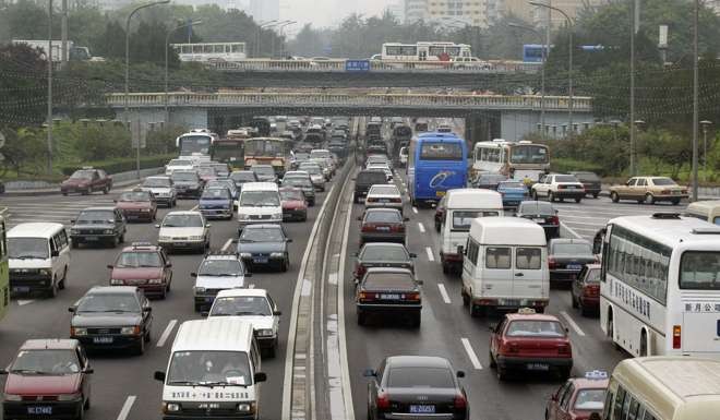
But traffic has not eased because of the supposedly non-stop expressways.

Beijing takes lead from London, Singapore as it plans congestion charges to curb capital’s huge traffic jams

Authorities said the seventh ring road was aimed to ease traffic pressure on Beijing, especially of cargo trucks, which no longer to pass through Beijing’s suburbs to reach Hebei.

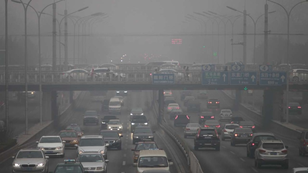
Some 500,000 vehicles use Beijing roads each day, causing noxious vehicle emissions, and the figure is expected to rise to 900,000, Beijing Business Today reported. Trucks also contribute to traffic jams in the northwest and southeast on highways linking Beijing to Hebei.

Authorities hope the ring would provide a new option for the capital’s road network, which currently placed all pressure on the sixth ring road as a detour in the case of major international events and emergencies.

http://www.scmp.com/news/china/poli...eijings-1000km-seventh-ring-road-more-closely
 
Sanjiang-Liuzhou Provincial Expressway S31
Guangxi Autonomous Region, Southwest China
A water expressway to open at the end of 2016


屏幕快照 2016-12-09 01.26.16.jpg


Sanjiang Dong Autonomous County
9c98ed17gw1e8ins2xpnmj20f0078gmn.jpg


u=1411135754,1135130570&fm=214&gp=0.jpg

屏幕快照 2016-12-09 01.34.23.png


HSR Station in Sanjiang Autonomous County
6284795232704901718.jpg


Liuzhou City
屏幕快照 2016-12-09 01.48.19.jpg

屏幕快照 2016-12-09 01.41.33.jpg
 
Beijing's '7th Ring Road' complete

China Daily, December 9, 2016

A 1,000-kilometer expressway linking Beijing and nearby cities in Hebei province was completed on Tuesday, which will ease traffic congestion and improve regional economic growth in the area.

The expressway linking Miyun district in Beijing and Zhuozhou in Hebei marks the completion of G95, a ring-road expressway, part of which is in the capital.

As Beijing already has six ring-roads within the city, the public has been calling the new expressway "the 7th Ring Road". However, only 38 km of the expressway goes through Beijing, with another 38 km in Tianjin, while the remaining 924 km runs through Hebei.

The expressway looks like a huge necklace, linking 13 major cities around Beijing, including the cities of Chengde, Langfang, Gu'an and Chongli, which will improve the transportation network of the Beijing-Tianjin-Hebei area.

"The Miyun-Zhuozhou expressway will reduce the traffic density of cargo trucks on current expressways in southeastern Beijing," Huo Leisheng, a road management officer of the expressway, was quoted as saying by Beijing Daily on Tuesday.

More importantly, the Miyun-Zhuozhou expressway will become the most convenient way to get between the two airports in Beijing.

"The integration of Beijing-Tianjin-Hebei requires a modern transportation network," said Zhang Guohua, a professor at the China Academy of Urban Planning and Design.

In recent years, Beijing has developed a system of ring and radial roads linking nearby areas in preparation for the region's integrated economic development.

Gao Jinhao, head of the traffic and transportation office of Hebei province, said the province takes up more than 80 percent of the Beijing-Tianjin-Hebei area, which means Hebei should bear more of the responsibility for building a modern comprehensive transportation network.

Previously, drivers had to go through Beijing when traveling between cities in Hebei, such as Shijiazhuang and Tangshan, or Zhangjiakou and Chengde. This not only reduces connectivity between areas, but causes traffic congestion in Beijing.

According to the authority, the road network in Hebei will reach 250,000 km, with expressways surpassing 9,000 km by 2020.

http://www.china.org.cn/china/2016-12/09/content_39883168.htm

Would like to see the picture.
 
Last edited:
Is there a map showing all the ring roads?
EDIT here you go http://cdn.static-economist.com/sit...size/images/print-edition/20150124_CNM988.png

subway lines will need to extend out also, just adding more ring roads won't solve the fundamental problem of high density.

or just move the government out from center of beijing so highrises can be built real tall. I suggest relocating the capital to Wuhan @AndrewJin

No, thanks, but no.....
We don't need those government headquarters to make Wuhan even more congested!

马鹦路立交。。.jpg
武汉天地。。.jpg
光谷转盘2.jpg
屏幕快照 2016-11-13 11.38.50.jpg


NO NEW RING EXPRESSWAY!
屏幕快照 2016-12-09 21.25.28.jpg
 
It's a good enough highway, but not a controlled-access expressway.
 
China's south-to-north water diversion project
2016-12-07 09:27 | Xinhua | Editor:Li Yan

936a1ab615c64116a868ab9ce93ec34d.jpg

Aerial photo taken on Nov. 30, 2016 shows the main canal of the central route of China's south-to-north water diversion project crossing through the Jiaozuo-Liuzhou Railway in central China's Henan Province. The central route of the project has supplied water to about 42 million people since December of 2014. A total of 6.09 billion cubic meters of water has been delivered to Beijing and Tianjin municipalities and the provinces of Hebei and Henan. (Photo/Xinhua)


6e1e23e53f354fba94efb4d6b7a4b163.jpg

Aerial photo taken on Nov. 30, 2016 shows the Songgang wharf of Danjiangkou Reservoir in Xichuan County, central China's Henan Province. The central route of China's south-to-north water diversion project has supplied water to about 42 million people since December of 2014. A total of 6.09 billion cubic meters of water has been delivered to Beijing and Tianjin municipalities and the provinces of Hebei and Henan. (Photo/Xinhua)


3217471b4d0d47ebab8b54744eb59931.jpg

Aerial photo taken on Dec. 1, 2016 shows the main canal of the central route of China's south-to-north water diversion project crossing through the city of Jiaozuo, central China's Henan Province. The central route of the project has supplied water to about 42 million people since December of 2014. A total of 6.09 billion cubic meters of water has been delivered to Beijing and Tianjin municipalities and the provinces of Hebei and Henan. (Photo/Xinhua)


29e2650c206f4f7699f6f06d5efcc4b5.jpg

Aerial photo taken on Nov. 30, 2016 shows the Taocha Canal Headworks of the central route of China's south-to-north water diversion project in Xichuan County, central China's Henan Province. The central route of the project has supplied water to about 42 million people since December of 2014. A total of 6.09 billion cubic meters of water has been delivered to Beijing and Tianjin municipalities and the provinces of Hebei and Henan. (Photo/Xinhua)


d9b2036d94cc449d889b6a87a0357733.jpg

Aerial photo taken on Dec. 1, 2016 shows the Shahe aqueduct of the central route of China's south-to-north water diversion project, central China's Henan Province. The central route of the project has supplied water to about 42 million people since December of 2014. A total of 6.09 billion cubic meters of water has been delivered to Beijing and Tianjin municipalities and the provinces of Hebei and Henan. (Photo/Xinhua)


629763e8dd6c4eb29fd3793f08936b22.jpg

Aerial photo taken on Dec. 6, 2016 shows the project of crossing the Yellow River in the central route of China's south-to-north water diversion project, central China's Henan Province. The central route of the project has supplied water to about 42 million people since December of 2014. A total of 6.09 billion cubic meters of water has been delivered to Beijing and Tianjin municipalities and the provinces of Hebei and Henan. (Photo/Xinhua)
 

Back
Top Bottom