What's new

A few Siachen facts and bluffs!

There are no remaining parts.

As with 'I' that you had highlighted - which I forgot to address - is entirely something else. The body text itself is divided in 2 parts. Part I is 'Introduction' and Part II is 'Agreement'. Due to scanning issue, the Part II got cropped in this document.

Just download UN document S/1430/Add.1 and go to Annexure 26. Alternatively, here is UN Treaty Series, Vol. 81.

Edit: Corrected document name and added link to 'UN Treaty Series'

i know what does the UN docs S/1430/Add.1, Add.2 and Add.3 or the S/1100, S/2967, S/2448 etc Interim Reports say. The argument here is on the connotation of "thence north to the glaciers" part of the KA-1949. You like to understand this as the CFL is to be extended beyond NJ9842, where as we and the self-explanatory KH01949 says that NJ9842 is the terminal point. Here's what the text you all like to quote says:

.....Chalunka (on the Shyok River), Khor, thence north to the glaciers. This portion of the cease- fire line shall be demarcated in detail on the basis of the factual position as of 27 July 1949, by the local commanders assisted by United Nations military observers.

What you dont like to see is the fol part of the agreement:

.....Chalunka (on the Shyok River), Khor, thence north to the glaciers. This portion of the cease- fire line shall be demarcated in detail on the basis of the factual position as of 27 July 1949, by the local commanders assisted by United Nations military observers.

So what needed to be demarcated? The alignment of CFL has been amply covered in KA-1949 in Sub Para 'B' 2 (a) to (d). The KA-1949 further says in para 'C':

C. The cease-fire line described above shall be drawn on a one- inch map (where available) and then be verified mutually on the ground by local commanders on each side with the assistance of the United Nations military observers, so as to eliminate any no-man's land. In the event that the local commanders are unable to reach agreement, the matter shall be referred to the Commission's Military Adviser, whose decision shall be final. After this verification,
Troops of either side were already there on ground, the area where there were no troops on ground was the area beyond NJ-9842 which was inaccessible - for the same reason the area beyond NJ-9842 was left indemarcated in 1947. The generalized mention of 'thence north to the glaciers' after alignment till Khor, despite giving a detailed explanation of the alignment prior to that indeed acknowledges the fact that by 'glaciers' (being inaccessible and thus indemarcated) the agreement infact made a reference upto NJ-9842: the last point which was accessible to man at that time.

How can they after pinpointing approximately 118 locations/reference point (that's what i have been able to roughly count between para B 2 (a) to (d)) to explain the alignment of CFL gave no further clear reference points to the CFL's alignment beyond Khor and just made a casual reference i.e thence north to the glaciers and despite the fact that there were no ground troops on the glacier, just handed over the same to India? Wow!

i mean, you actually want us to believe that after painstakingly using 677 words (between para B 2 (a) and (d) - till the word Khor) to explain the CFL, those geniuses just said, "hey, we are tired of this shyt, let's just say 'thence north to the glaciers' and forget that:

- NJ9842 is the last place which can be reached.
- there has been no fighting for the claim of the area beyond NJ 9842.
- there are no troops beyond NJ 9842.
- though the question of Siachen's claim has even not been raised during the agreement.

Still, just hand the bloody thing to India?!"

Yeah, right!! i mean, you guys are more unbelievable then these friends of yours:


On a serious note, please tell, going by your understanding of 'thence north', where would this CFL, traveling North, without any mention of a terminal point, would end? Not at the North Pole, i hope?

As the area beyond NJ9842 (the glacier itself) was inaccessible, unmarked, unknown at that time, by 'thence north towards the glaciers' have no other connotation except that the CFL, moving up north, terminated at NJ9842 - the last point known, accessed and marked on map.
 
Last edited:
.
Was I banging my head against the wall when I said Karachi agreement was silent on points beyond NJ9842???
Albeit "thence north to glacier" does give an idea to whom the glaciers belonged.
But for some reason you choose to ignore the words "north to glaciers".
Are you actually that stupid or you are just pretending to be one?

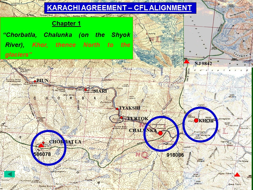
One one side you agree that Karachi Agreement was 'silent on points beyond NJ9842', but in the same breath you again try to shove BS down our throats by saying that 'thence north to the glacier' imply that the CFL extends beyond NJ9842 to the glacier?? Can you even see the distance to NJ9842 from Khor? Here, may be this slide could help you:

14794097215_30a29b645f_o.jpg


In the text of KA-1949, "...Khor, thence north to the glacier" means (if commonsense is utilized): from Khor, thence north to the glacier i.e upto NJ9842 (the last point man was able to reach till 1949 - beyond that the territory is unknown and thus cannot and was not demarcated and thus cannot be claimed by India just because she like to extrapolate 'thence north' to wherever she wants). Moreover, you have yourself agreed that KA-1949 is "silent" on points beyond NJ9842!!!

If KA-49 is silent - as you agree- how can the KA-49 at the same time also extend the CFL beyond NJ9842 (to the glaciers)? The reference to glaciers is till NJ 9842.

i really dont care.

I have posted a map in my OP, but then I guess you chose to ignore it too.
And i have posted many, and they were not made by some e-warrior while using google maps.

Unless you prove what is it that is written on "page 38", till then don't expect me to take your slides seriously.
The KA-49 is amply clear even without that page.

Even if you did, you will not be able to prove that the point beyond NJ9842 belonged to Pakistan during any point in history.

But you can prove that it belonged to India? How?

To answer to your emotional rant, i wwould just say that not only me, but well beyond our independence, the international community have been subtly showing that the point beyond NJ9842 did belong to Pakistan.

I can see that our debate is headed nowhere. So let me reinstate my points....
You cant push people around without logic, so yes, the debate indeed isnt headed nowhere.

1) I was talking about "thence North to GLACIERS".
Me too.
2) It takes an iota of common sense to understand that the most recent agreement is always considered valid, ergo I brought Shimla agreement into discussion.
As i have said earlier, my focus is Karachi Agreement and the fact that 'thence north' as mentioned in its text, does not give any credence to India over Siachen. Yes, if you want to discuss the current position, we can always include not only Simla Agreement but all the UNCIP reports since 1948.

3) so why were we discussing discussing Karachi agreement? To prove that Siachen never belonged to you.
i think you confused it. It was being discussed that Siachen never belonged to you. Read the Agreement 10 times, and then come back here.

4) According to Shimla agreement siachen became a part of India when India captured the Turtok salient.

Again, first decide, are we discussing the current position on Siachen/AGLP or what history says about Siachen?

5) According to the watershed principle of demarcating borders and lines of control in mountains region, the high crest separating the two watersheds is considered the natural demarcation. Now north of NJ-9842 there are two glaciers namely the Siachen Glacier and Baltoro Glacier which is divided by the Saltoro Ridge, which also forms a natural watershed between the two glaciers.
Do you even know what watershed actually means?
i'd suggest, you go read about it first before try to experiment with it.

Proves NOTHING. Sorry.

6) Care to explain the lack of protests from Pakistani side when when in 1956 (through 58) an Indian scientific team led by the Geological Survey explored the upper Nubra and Shyok Valleys, mapped and measured the Siachen and other glaciers and publicly recorded its findings???
One fringing expedition?

Care to explain the lack of protest by India when these teams came to study the Glacier after they have sought permission from Pakistan:

- In 1957, the mountaineering team of Royal Imperial College, led by Mr. Eric Shipton, came to study the Siachen glaciers, Rimo glacier and K-12 peak.
- Between 1961 and 1962, two Australian teams conquered the peaks of Sia-kangri.
- Between 1961 and 1962, three Japenese teams went to Siachen glaciers, included in these teams was Pakistan-Japan Soltoro Expedition, for the very first time conquered the Soltoro Kangri peaks. Included in this expedition was Kyoto Alpine Club of Japan, with two Pakistanis, Raja Bashir and Pervez A Khan.

And where was India when the fol mountaineering expeditions took permission from Pakistan:

1. 1974- Japanese Kwoto university- Karakoram mission to conquer K-2 at the heights of 74680 meters.
2. 1975-UK North-West Karakoram Expedition- To conquer Sherbi Kangri at height of 23960 feet.
3. 1976- German KK Himalaya Expedition- For Salotre Kangri at 77060 Meters.
4. 1978- Japanese Kojo Alpine KK Expedition- Terim Glaciers at 6476 Meters.
5. 1980- Mr. Glen Roel-USA KK skating and tracking party-Lofound Glaciers.

Surprisingly, you people started fancying Siachen around '84;

6. 1984-Austrian Arex Expedition for K-12; were given permission by Pakistan, effective for June , but Indians landed forces in April 1984.
 
.
1) This map is from Xeric's thread, show me the original source. It can not be an Indian map.

View attachment 224591

2) Even if the map is pre-1984 then you must remember that UN made a cartographic error in maps in 1967.
View attachment 224585

View attachment 224590


Thanks!!
I reverse searched the image and found no source to this image other than Xeric's thread on pdf.
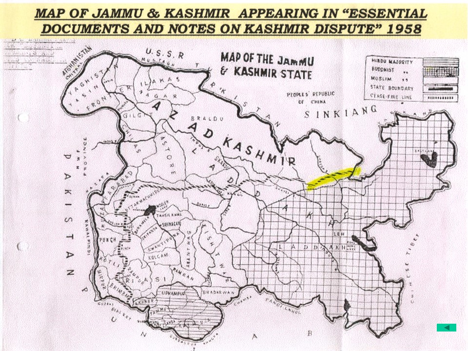
Indian map? Really? If it was an India map, it would not have referred to Azad Kashmir as 'AZAD KASHMIR' as shown!! This is a Pakistani map! Epic fail!!
14790966591_22e3119c6e_o.jpg

The map is from an Indian book (Essential documents and notes on Kashmir dispute, 1958), written by an Stockholm-based journalist of Indian origin namely P. L. Lakhanpal and published by 'New Delhi: International Publications' in 1958, and the hence the map is an Indian (fcuking) map!


Essential Documents and Notes on Kashmir Dispute. With a map: Amazon.co.uk: P. L. Lakhanpal: Books

Catalog Record: Essential documents and notes on Kashmir dispute | Hathi Trust Digital Library

Essential documents and notes on Kashmir dispute / P. L. Lakhanpal | National Library of Australia
 
Last edited:
.
Are you actually that stupid or you are just pretending to be one?

One one side you agree that Karachi Agreement was 'silent on points beyond NJ9842', but in the same breath you again try to shove BS down our throats by saying that 'thence north to the glacier' imply that the CFL extends beyond NJ9842 to the glacier?? Can you even see the distance to NJ9842 from Khor? Here, may be this slide could help you:

14794097215_30a29b645f_o.jpg


In the text of KA-1949, "...Khor, thence north to the glacier" means (if commonsense is utilized): from Khor, thence north to the glacier i.e upto NJ9842 (the last point man was able to reach till 1949 - beyond that the territory is unknown and thus cannot and was not demarcated and thus cannot be claimed by India just because she like to extrapolate 'thence north' to wherever she wants). Moreover, you have yourself agreed that KA-1949 is "silent" on points beyond NJ9842!!!

If KA-49 is silent - as you agree- how can the KA-49 at the same time also extend the CFL beyond NJ9842 (to the glaciers)? The reference to glaciers is till NJ 9842.

i really dont care.

And i have posted many, and they were not made by some e-warrior while using google maps.

The KA-49 is amply clear even without that page.


But you can prove that it belonged to India? How?

To answer to your emotional rant, i wwould just say that not only me, but well beyond our independence, the international community have been subtly showing that the point beyond NJ9842 did belong to Pakistan.

You cant push people around without logic, so yes, the debate indeed isnt headed nowhere.

Me too.

As i have said earlier, my focus is Karachi Agreement and the fact that 'thence north' as mentioned in its text, does not give any credence to India over Siachen. Yes, if you want to discuss the current position, we can always include not only Simla Agreement but all the UNCIP reports since 1948.


i think you confused it. It was being discussed that Siachen never belonged to you. Read the Agreement 10 times, and then come back here.


Again, first decide, are we discussing the current position on Siachen/AGLP or what history says about Siachen?


Do you even know what watershed actually means?
i'd suggest, you go read about it first before try to experiment with it.

Proves NOTHING. Sorry.


One fringing expedition?

Care to explain the lack of protest by India when these teams came to study the Glacier after they have sought permission from Pakistan:

- In 1957, the mountaineering team of Royal Imperial College, led by Mr. Eric Shipton, came to study the Siachen glaciers, Rimo glacier and K-12 peak.
- Between 1961 and 1962, two Australian teams conquered the peaks of Sia-kangri.
- Between 1961 and 1962, three Japenese teams went to Siachen glaciers, included in these teams was Pakistan-Japan Soltoro Expedition, for the very first time conquered the Soltoro Kangri peaks. Included in this expedition was Kyoto Alpine Club of Japan, with two Pakistanis, Raja Bashir and Pervez A Khan.

And where was India when the fol mountaineering expeditions took permission from Pakistan:

1. 1974- Japanese Kwoto university- Karakoram mission to conquer K-2 at the heights of 74680 meters.
2. 1975-UK North-West Karakoram Expedition- To conquer Sherbi Kangri at height of 23960 feet.
3. 1976- German KK Himalaya Expedition- For Salotre Kangri at 77060 Meters.
4. 1978- Japanese Kojo Alpine KK Expedition- Terim Glaciers at 6476 Meters.
5. 1980- Mr. Glen Roel-USA KK skating and tracking party-Lofound Glaciers.

Surprisingly, you people started fancying Siachen around '84;

6. 1984-Austrian Arex Expedition for K-12; were given permission by Pakistan, effective for June , but Indians landed forces in April 1984.
Do you believe Karachi agreement and "thence north" clause gave siachen to pakistan?
 
.
Do you believe Karachi agreement and "thence north" clause gave siachen to pakistan?
No.

But neither does it give it to India. That's the whole debate is about. It is you guys who like to think by 'thence north-ing' the KA-49 somehow gave Siachen to you.

Nevertheless, Siachen belonged to Pakistan, as accepted and displayed by the international community.
 
.
No.

But neither does it give it to India. That's the whole debate is about. It is you guys who like to think by 'thence north-ing' the KA-49 somehow gave Siachen to you.

Nevertheless, Siachen belonged to Pakistan, as accepted and displayed by the international community.
So, who owned that land before 1949? And no "accepted by international community" please. It doesn't work that way...
 
. .
i know what does the UN docs S/1430/Add.1, Add.2 and Add.3 or the S/1100, S/2967, S/2448 etc Interim Reports say.
S/1430/Add.1/Annx.26 is the Karachi Agreement, 1949. My reference to this document was for you to remove any doubt about ‘chapters’ in Karachi Agreement. I had also made reference to UN Treaty Series, Vol. 81 for the same reason.

I am glad you have made your arguments on the basis of these documents and not some non-existent ‘chapters’

... the agreement infact made a reference upto NJ-9842: the last point which was accessible to man at that time.
Actually, the Agreement makes no such reference. The last point identified by the Agreement is Khor. The grid reference NJ-9842 comes from the accompanying map.


...just made a casual reference i.e thence north to the glaciers and despite the fact that there were no ground troops on the glacier, just handed over the same to India? Wow!
Yes, since Kashmir had legally acceded to India, something which even UN didn’t question – surprise! surprise!


On a serious note, please tell, going by your understanding of 'thence north', where would this CFL, traveling North, without any mention of a terminal point, would end? Not at the North Pole, i hope?
It would end – as commonsense dictates – at the nearest recognized international border.

As the area beyond NJ9842 (the glacier itself) was inaccessible, unmarked, unknown at that time, by 'thence north towards the glaciers' have no other connotation except that the CFL, moving up north, terminated at NJ9842 - the last point known, accessed and marked on map.
Again, commonsense dictates, that the exact wording of the Agreement, ‘Khor, thence north to the glaciers imply that the CFL shall continue northwards, beyond Khor, until it terminates at the nearest recognized international boundary. Anything to the east of this line would automatically belong to India. Unfortunately for you, that encompasses the whole of Siachen glacier.

In the text of KA-1949, "...Khor, thence north to the glacier" means (if commonsense is utilized): from Khor, thence north to the glacier i.e upto NJ9842 (the last point man was able to reach till 1949 - beyond that the territory is unknown and thus cannot and was not demarcated and thus cannot be claimed by India just because she like to extrapolate 'thence north' to wherever she wants). Moreover, you have yourself agreed that KA-1949 is "silent" on points beyond NJ9842!!!

If KA-49 is silent - as you agree- how can the KA-49 at the same time also extend the CFL beyond NJ9842 (to the glaciers)? The reference to glaciers is till NJ 9842.
No.


But neither does it give it to India. That's the whole debate is about. It is you guys who like to think by 'thence north-ing' the KA-49 somehow gave Siachen to you.


Nevertheless, Siachen belonged to Pakistan, as accepted and displayed by the international community.
The sum of your argument – if I have gotten it right – is that beyond NJ-9842 is no-man’s land, since it was ‘unmarked’ and ‘unclaimed’ at the time of Karachi Agreement 1949. Fine. But wouldn’t that make the area free for all – finders, keepers.

So when India occupied the heights, we were not violating any international law, or agreement.

We ‘found’ it first, had it ‘marked’ and now it is legally ‘claimed’.

Problem solved. What’s the fuss then.
 
Last edited:
.
Actually, the Agreement makes no such reference. The last point identified by the Agreement is Khor. The grid reference NJ-9842 comes from the accompanying map.
Here, comes the function of commonsense. Being the last recognizable, known and explored point in that area, the reference to '..khor, thence north' would mean the CFL ends at that last 'recognizable' point, not to some la la land.


Yes, since Kashmir had legally acceded to India, something which even UN didn’t question – surprise! surprise!
Lol. Kashmir 'legally' acceded to india, but then the KA-1949 is painstakingly demarcating mainland Kashmir between the two countries, however, it made, through a casual reference Siachen, an area unknown, unexplored and unclaimed, part of India too. No!


It would end – as commonsense dictates – at the nearest recognized international border.


Again, commonsense dictates, that the exact wording of the Agreement, ‘Khor, thence north to the glaciers imply that the CFL shall continue northwards, beyond Khor, until it terminates at the nearest recognized international boundary. Anything to the east of this line would automatically belong to India. Unfortunately for you, that encompasses the whole of Siachen glacier.

The commonsense dictates that it ends at the next or last recognizable feature, both the next and last known feature in this case i.e NJ9842.

Boundaries are drawn/reconnoitered on ground and later marked on maps, not the otherway round, based on actual ground features. The approx 118 features/locations that the Karachi Agreement made use of to demarcate the boundary on the map is one example.

As we all agree that area beyond NJ9842 was neither mapped, nor explored at that time. So, no one, if commonsense, is the keyword here, would just let you to draw an arbitrary line on a map to claim some territory. i mean, you really wants us to believe that boundary disputes are resolved while sitting inside big halls and making lines on a piece of paper we call maps? Sorry, it doesnt happen that way.

The sum of your argument – if I have gotten it right – is that beyond NJ-9842 is no-man’s land, since it was ‘unmarked’ and ‘unclaimed’ at the time of Karachi Agreement 1949. Fine. But wouldn’t that make the area free for all – finders, keepers.

So when India occupied the heights, we were not violating any international law, or agreement.

We ‘found’ it first, had it ‘marked’ and now it is legally ‘claimed’.

Problem solved. What’s the fuss then.
So, you agree that Saichen never belonged to you by any clause of either the Karachi Agreement or the Simla Agreement, and that you just barged into and captured it, breaking every norm known to mankind in the 20th Century, including the doctrine of Westphalian Sovereignty. Now, having proved that Siachen did not belong to India, the case that whether Siachen belonged to us is a topic for another debate. We can go over that too, if you want.

Thankyou, case closed!

Siachen belonged to Pakistan? Really? Ok, come and get it.

Your SSG which you consider the best special forces in the world, (Jeeez!!!) failed to capture it even after 4 earlier failed attempts with heavy casualties. You're welcome to try again! :P
Stop behaving like an idiot, please.
 
.
Here, comes the function of commonsense. Being the last recognizable, known and explored point in that area, the reference to '..khor, thence north' would mean the CFL ends at that last 'recognizable' point, not to some la la land.
Nope... to the international boundary with China.
 
.
Nope... to the international boundary with China.
Just because the guys working on Karachi Agreement knew that one day, 'geniuses' like you, the hunter guy and the the one who still idolizes spinach would overload their commonsense and fail to understand simple English. So, they also prepared a map for their easy comprehension, but they also failed to understand that. But then, i was here too, and it is indeed my profound privilege to help them out:

The said map (UN doc no S/1430/Add.2) showing the Cease-Fire Line can be accessed here: http://repository.un.org/bitstream/handle/11176/87063/S_1430_Add.2-EN.pdf?sequence=2&isAllowed=y

However, posting the snapshots:

1.JPG


2.JPG


3.JPG


But the again, as i also know that having failed to read and comprehend simple English, these guys would also be unable to read and understand the map itself, i will help them out again by superimposing the the above maps as overlays on to Google Earth (images). The overlay is placed with fair accuracy as can be seen from the synchronized alignment of the borders of Pakistan and AJK and matching grid lines:

1. The over view of the overlays onto Google Earth:

Overview_CFL-KA1949.jpg


2. Zoomed in to show the matching alignment of borders both as shown on the map ex UU doc and Google Earth. It can also be seen that the map makers at UN did not extend the CFL 'thence north to the glaciers' as Indians like to claim:

CFL terminated at NJ9842.jpg


3. The same image with 50% transparency of opverlays, for those who have weak eyesight, weak hearts and tiny brains:

CFL.jpg


4. Final, the area which actually matters have been zoomed in. Landmarks as mentioned in Karachi Agreement (Chulanka, Turtuk etc) have been marked. The UN Map ex Karachi Agreement clearly shows that the CFL ended at NJ9842 and when they wrote "..Khor, thence north to the glaciers", it meant that thence north to the glaciers (upto the last point known i.e. NJ9842):

Zoomed CFL.jpg


Had the story been as the Indians like to claim, they would have very well drawn the CFL (atleast on the map) till the Chinese border, instead of terminating it at NJ9842. Because if they had the cheeks to had over a 70 km long glacier to India just by the stroke of a pen, they very well could also have chosen a (suitable) point on the Chinese border to denote the termination of CFL there, and thereby puting Siachen Glacier towards the Indian side of the CFL. Sorry guys, that just did not happen.
 
. . .
Here, comes the function of commonsense. Being the last recognizable, known and explored point in that area, the reference to '..khor, thence north' would mean the CFL ends at that last 'recognizable' point, not to some la la land.
Actually this where you don’t have to apply common sense. It is in black and white.

Khor, thence north to the glaciers. This portion of the cease- fire line shall be demarcated in detail on the basis of the factual position as of 27 July 1949, by the local commanders assisted by United Nations military observers.

Since ‘thence north to the glaciers’ from Khor upto the nearest recognized international boarder was only partially demarcated, only upto NJ-9842, the rest of it was supposed to be done so, after the agreement. It is another matter that it didn’t happen. The intention, was made clear in the text.

Lol. Kashmir 'legally' acceded to india, but then the KA-1949 is painstakingly demarcating mainland Kashmir between the two countries, however, it made, through a casual reference Siachen, an area unknown, unexplored and unclaimed, part of India too. No!
As incredible as it may sound, that is what it is. KA was needed to establish Cease Fire par UN Resolution. It was supposed to be temporary. Remember how you had to withdraw completely and hand over administration to local authority etc.?

So, you agree that Saichen never belonged to you by any clause of either the Karachi Agreement or the Simla Agreement, and that you just barged into and captured it, breaking every norm known to mankind in the 20th Century, including the doctrine of Westphalian Sovereignty. Now, having proved that Siachen did not belong to India, the case that whether Siachen belonged to us is a topic for another debate. We can go over that too, if you want.

Thankyou, case closed!
How you have managed to gather that I have agreed ‘that Siachen never belonged’ to us, I would never know. I was merely pointing out – apparently that pointing out needs to be pointed out – the fallacy of your argument. So here it is again, for your understanding:

If you are trying to prove that Siachen was neither India’s nor Pakistan’s, at least after Karachi Agreement, then it implies that Siachen was free land waiting for one of the parties to stake a claim. India has staked that claim by being physically present there. Hence Siachen today belongs to India. That is going by your, demonstrably wrong interpretation of KA.

As with your reference to ‘Westphalian Sovereignty’, try not to throw around terms that you do not fully comprehend. If you invoke Westphalian Sovereignty, you are in fact claiming that Siachen was part of Pakistan all along. But by your own argument, Siachen was a free land till India staked claim in 1984.
 
.
@OrionHunter

Sir I have been looking on the internet for the name of the London firm which tipped of India

It sold Arctic gear to India and was approached by PA to buy the same

Can you help
 
.

Pakistan Defence Latest Posts

Pakistan Affairs Latest Posts

Back
Top Bottom