ghazi52
PDF THINK TANK: ANALYST

- Joined
- Mar 21, 2007
- Messages
- 101,794
- Reaction score
- 106
- Country

- Location

The Famous Glaciers in Pakistan
Abruzzi Glacier
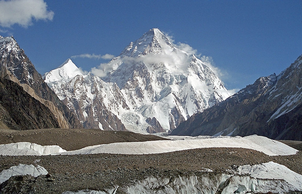
The Abruzzi Glacier is a glacier north of the Baltoro Kangri peak in Gilgit-Baltistan, Pakistan. The glacier joins the Baltoro Glacier (one of the largest glaciers outside the polar region) that flows northwest in the beginning and then turns westward. The glacier provides superb views of K2, the highest peak in Pakistan.
The glacier was named in honor of Prince Luigi Amedeo, Duke of the Abruzzi an Italian mountaineer and arctic explorer who led an expedition to the Karakoram mountain range in 1909, including several partial ascents of K2.
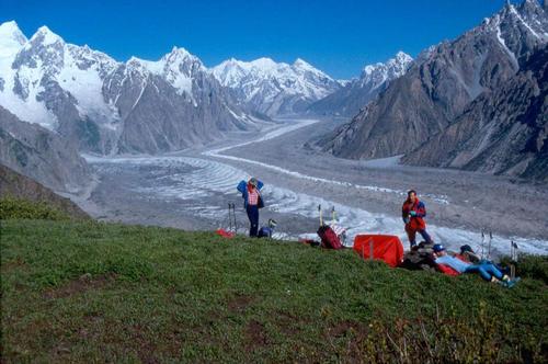
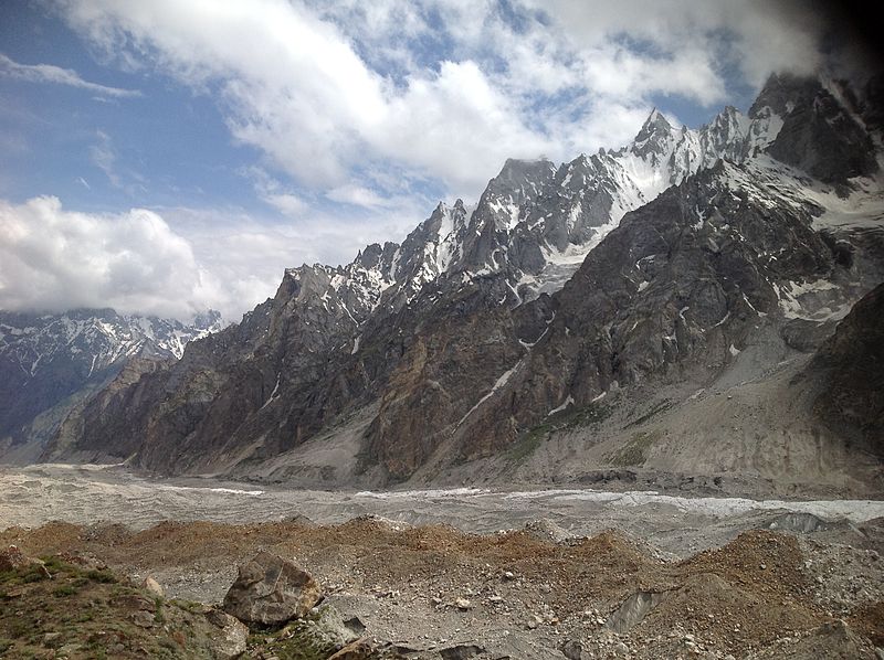
Baltoro Glacier
The Baltoro Glacier at 63 km (39 mi) in length, is one of the longest glaciers outside the polar regions. It is located in the Gilgit-Baltistan region of Pakistan. It runs through part of the Karakoram mountain range. The Baltoro Muztagh lies to the south and east of the glacier, while the Masherbrum Mountains lie to the south. At 8,611 m (28,251 ft), K2 is the highest mountain in the region, and three other Eight thousanders within 20 km.
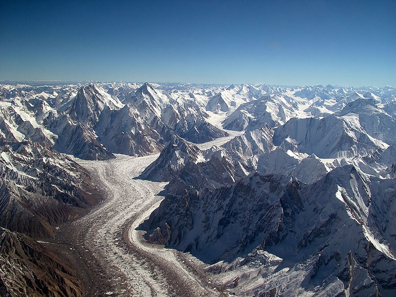
The glacier gives rise to the Shigar River, which is a tributary of the Indus River. Several large tributary glaciers feed the main Baltoro Glacier, including the Godwin Austen Glacier, flowing south from K2; the Abruzzi and the various Gasherbrum Glaciers, flowing from the Gasherbrum group of peaks; the Vigne Glacier, flowing from Chogolisa, and the Yermandendu Glacier, flowing from Masherbrum. The confluence of the main Baltoro Glacier with the Godwin Austen Glacier is known as Concordia; this location and K2 base camp are popular trekking destinations.
The trough of this glacier is very wide. Small valley glaciers form icefalls where they meet the trunk glacier. The sidewalls vary from very steep to precipitous. The glacier has carved striations on the surrounding country rocks. Moving ice has formed depressions, which serve as basins for numerous glacial lakes.
The glacier can be approached via the Balti town of Skardu.
Batura Glacier
Batura Glacier, 57 kilometres (35 mi) long, is one of the largest and longest glaciers outside of the polar regions. It lies in the Gojal region of Gilgit-Baltistan in Pakistan. It is just north of the massifs of Batura, at 7,795 metres (25,574 ft), and Passu, at 7,500 metres (24,600 ft). The glacier flows west to east. The lower portions can be described as a grey sea of rocks and gravelly moraine, bordered by a few summer villages and pastures with herds of sheep, goats, cows and yaks and where roses and juniper trees are common.
Biafo Glacier
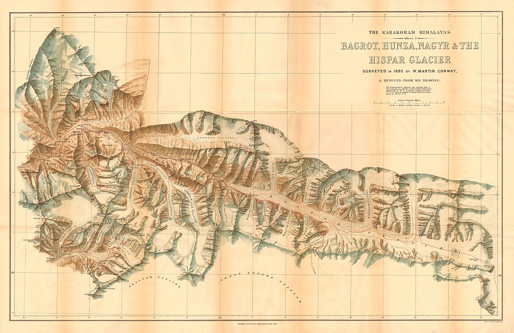
The Biafo Glacier is a 67 km (42 mi) long glacier in the Karakoram Mountains of Gilgit Baltistan, Pakistan-administrated Kashmir which meets the 49 km (30 mi) long Hispar Glacier at an altitude of 5,128 m (16,824 ft) at Hispar La (Pass) to create the world’s third longest glacial system after Siachen glacier outside the polar regions. This highway of ice connects two ancient mountain kingdoms, Nagar, in the west with Baltistan in the east. The traverse uses 51 of the Biafo Glacier’s 67 km and all of the Hispar Glacier to form a 100 km (62 mi) glacial route.
The Biafo Glacier presents a trekker with several days of strenuous boulder hopping, with views throughout and Snow Lake near the high point. Snow Lake, consisting of parts of the upper Biafo Glacier and its tributary glacier Sim Gang, is one of the world’s largest basins of snow or ice in the world outside the polar regions, up to 1,600 m (0.99 mi) in depth.
The Biafo Glacier is the world’s third longest glacier outside the polar regions, second only to the 70 km (43 mi) Siachen Glacier, India-Pakistan and Tajikistan’s 77 km (48 mi) long Fedchenko Glacier.
Campsites along the Biafo are located off of the glacier, adjacent to the lateral moraines and steep mountainsides. The first three (heading up from the last village before the glacier, the thousand-year-old Askole village) are beautiful sites with flowing water nearby. Mango and Namla, the first two campsites, are often covered in flowers and Namla has an amazing waterfall very near the camping area. Baintha, the third camp site, is often used as a rest day. A large green meadow, it has a few running streams near the camp and many places to spend the day rock climbing or rappelling.
Evidence of wildlife can be seen on the trek, including Ibex and the Markhor Mountain Goat. The area is also known for Himalayan brown bears and snow leopards, although sightings are rare.
Biarchedi Glacier
The Biarchedi Glacier is located on the northeast of Biarchedi Peak in Pakistan. It flows north into the Baltoro Glacier.
Bilafond Glacier
Bilafond Glacier is located in Siachen region across Karakoram Range in Pakistan. It is a main source for Saltoro River.It is under Pakistani control.
Godwin-Austen Glacier
The Godwin-Austen Glacier is a glacier in the Karakoram, close to K2 in the Pakistani region of Gilgit Baltistan. Its confluence with the Baltoro Glacier is called Concordia and is a popular trekking destination as it provides views of four of the five eight-thousanders in the region.
The glacier can be approached via the Balti town of Skardu. It receives its name from Henry Haversham Godwin-Austen, an early explorer of this region. K2 was originally named Mount Godwin-Austin in his honour.
Gondogoro Glacier
Gondogoro Glacier or Gondoghoro Glacier is glacier near Concordia in Gilgit-Baltistan, Pakistan. It serves as an alternative means to reach Concordia; the confluence of Baltoro Glacier and Godwin-Austen Glacier.
Hainablak Glacier
Hainablak Glacier is a glacier near Trango Tower mountain in Baltistan, Gilgit-Baltistan, Pakistan.
Hispar Glacier
Hispar Glacier is a 49 km (30 mi) long glacier in the Karakoram Mountains of Gilgit–Baltistan, Pakistan which meets the 63 km (39 mi) long Biafo Glacier at the Hispar La (Pass) at an altitude of 5,128 m (16,824 ft) to create the world’s longest glacial system outside of the polar regions.
Kutiah Lungma Glacier
Kutiah Lungma Glacier is a 12 km long and 3 km wide glacier in Karakorum mountain ranges in Stak Valley of District Skardu, Gilgit-Baltistan, Pakistan. It is located in a valley, Stak Valley (sometimes also referred to as Staq), which is in the subdivision Roundu of district Skardu Gilgit-Baltistan.
The glacier is in the north of Nanga Parbat (the ninth highest peak of the world), about 20 kilometers away from the northern bank of the Indus River. One can access the glacier from June–September from Skardu or Gilgit city, as it is about 10 km away from the Gilgit-Skardu road. An un-metalled road from Gilgit-Skardu Road at the junction of Indus River and Stak Valley stream leads to the base camp of the glacier.
Miar Glacier
Miar Glacier is a glacier that forms in the north of Miar Peak (6,824 m (22,388 ft)) in Hoper Valley in Nagar, Gilgit-Baltistan, Pakistan. It is a major component of the Barpu Glacier.
Panmah Glacier
Panmah Glacier is a glacier in Gilgit-Baltistan, Pakistan. It is included in the Central Karakoram National Park.
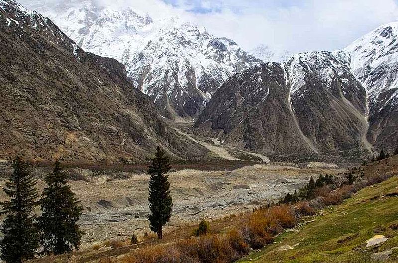
Passu Glacier
Passu Glacier is situated in the south side of Passu village. Passu Peak is situated in the back side of the glacier. This glacier is linked with Batura Glacier and many other glaciers of the region.

Rupal Glacier
Rupal Glacier or Tashain Glacier is a glacier in the Great Himalaya subrange of Himalayas. It starts north of an unnamed 6,326-metre-high (20,755 ft) peak (35°8′35.93″N 74°24′52.46″E) and flows northeastward, north of Laila Peak (Rupal Valley) and south of Nanga Parbat’s many peaks. The meltwater from the glacier forms Rupal River.
Rimo I
Rimo I is the main summit of the Rimo massif with an elevation of 7,385 metres (24,229 ft). It lies in the northern part of the remote Rimo Muztagh, a subrange of the Karakoram range. It is located about 20 km northeast of the snout of the Siachen Glacier and is the world’s 71st highest mountain. Rimo means “striped mountain”. The Rimo Glacier, originating here, drains to the Shyok river.

Due to its remote location in the heart of the eastern Karakoram, Rimo was little-known and almost entirely unvisited until the twentieth century. Explorers Filippo De Filippi and Philip and Jenny Visser visited the area in 1914 and 1929 respectively. Adding to its isolation is the unsettled political and military situation between India and Pakistan in the region, especially on the nearby Siachen Glacier. This means that India controls access to the massif.
Sarpo Laggo Glacier
The Sarpo Laggo Glacier (Sarpo Laggo: young husband) is a glacier in the autonomous region Xinjiang of China, in the Karakoram mountain range of the Himalayas. It lies north of the Baltoro Muztagh range. It could be reached from the Baltoro glacier on the Pakistani side of the Karakorams via the Old Muztagh Pass northeast of the Trango Towers. It is however easier to approach the glacier from the Chinese side, starting a long hike at Kashgar on the Karakoram Highway and finally passing K2’s northern base camp.
The Glacier is named after Francis Younghusband, who was the first person to pass the Old Mustagh Pass and thus enter the Sarpo Laggo region. There is another glacier not far away, also named after him: Younghusband glacier (also known as Biango glacier) flows from Muztagh Tower towards the Baltoro Glacier.

Shani Glacier
Shani Glacier is a glacier in the north of Shani Peak (5,887 m (19,314 ft)) in Naltar Valley, Pakistan.
Siachen Glacier
The Siachen Glacier is a glacier located in the eastern Karakoram range in the Himalayas at about 35.421226°N 77.109540°E, just northeast of the point NJ9842 where the Line of Control between India and Pakistan ends. At 76 km (47 mi) long, it is the longest glacier in the Karakoram and second-longest in the world’s non-polar areas. It falls from an altitude of 5,753 m (18,875 ft) above sea level at its head at Indira Col on the China border down to 3,620 m (11,875 ft) at its terminus. The entire Siachen Glacier, with all major passes, is currently under the administration of India since 1984. Pakistan controls the region west of Saltoro Ridge, far away from the glacier,with Pakistani posts located 3,000 ft below more than 100 Indian posts on Saltoro Ridge.
The Siachen Glacier lies immediately south of the great drainage divide that separates the Eurasian Plate from the Indian subcontinent in the extensively glaciated portion of the Karakoram sometimes called the “Third Pole”. The glacier lies between the Saltoro Ridge immediately to the west and the main Karakoram range to the east.
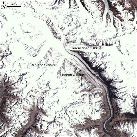
The Saltoro Ridge originates in the north from the Sia Kangri peak on the China border in the Karakoram range. The crest of the Saltoro Ridge’s altitudes range from 5,450 to 7,720 m (17,880 to 25,330 feet). The major passes on this ridge are, from north to south, Sia La at 5,589 m (18,336 ft), Bilafond La at 5,450 m (17,880 ft), and Gyong La at 5,689 m (18,665 ft). The average winter snowfall is more than 1000 cm (35 ft) and temperatures can dip to −50 °C (−58 °F). Including all tributary glaciers, the Siachen Glacier system covers about 700 km2 (270 sq mi).

 www.karakorumexpedition.com
Abruzzi Glacier
The Abruzzi Glacier is a glacier north of the Baltoro Kangri peak in Gilgit-Baltistan, Pakistan. The glacier joins the Baltoro Glacier (one of the largest glaciers outside the polar region) that flows northwest in the beginning and then turns westward. The glacier provides superb views of K2, the highest peak in Pakistan.
The glacier was named in honor of Prince Luigi Amedeo, Duke of the Abruzzi an Italian mountaineer and arctic explorer who led an expedition to the Karakoram mountain range in 1909, including several partial ascents of K2.
Baltoro Glacier
The Baltoro Glacier at 63 km (39 mi) in length, is one of the longest glaciers outside the polar regions. It is located in the Gilgit-Baltistan region of Pakistan. It runs through part of the Karakoram mountain range. The Baltoro Muztagh lies to the south and east of the glacier, while the Masherbrum Mountains lie to the south. At 8,611 m (28,251 ft), K2 is the highest mountain in the region, and three other Eight thousanders within 20 km.
The glacier gives rise to the Shigar River, which is a tributary of the Indus River. Several large tributary glaciers feed the main Baltoro Glacier, including the Godwin Austen Glacier, flowing south from K2; the Abruzzi and the various Gasherbrum Glaciers, flowing from the Gasherbrum group of peaks; the Vigne Glacier, flowing from Chogolisa, and the Yermandendu Glacier, flowing from Masherbrum. The confluence of the main Baltoro Glacier with the Godwin Austen Glacier is known as Concordia; this location and K2 base camp are popular trekking destinations.
The trough of this glacier is very wide. Small valley glaciers form icefalls where they meet the trunk glacier. The sidewalls vary from very steep to precipitous. The glacier has carved striations on the surrounding country rocks. Moving ice has formed depressions, which serve as basins for numerous glacial lakes.
The glacier can be approached via the Balti town of Skardu.
Batura Glacier
Batura Glacier, 57 kilometres (35 mi) long, is one of the largest and longest glaciers outside of the polar regions. It lies in the Gojal region of Gilgit-Baltistan in Pakistan. It is just north of the massifs of Batura, at 7,795 metres (25,574 ft), and Passu, at 7,500 metres (24,600 ft). The glacier flows west to east. The lower portions can be described as a grey sea of rocks and gravelly moraine, bordered by a few summer villages and pastures with herds of sheep, goats, cows and yaks and where roses and juniper trees are common.
Biafo Glacier
The Biafo Glacier is a 67 km (42 mi) long glacier in the Karakoram Mountains of Gilgit Baltistan, Pakistan-administrated Kashmir which meets the 49 km (30 mi) long Hispar Glacier at an altitude of 5,128 m (16,824 ft) at Hispar La (Pass) to create the world’s third longest glacial system after Siachen glacier outside the polar regions. This highway of ice connects two ancient mountain kingdoms, Nagar, in the west with Baltistan in the east. The traverse uses 51 of the Biafo Glacier’s 67 km and all of the Hispar Glacier to form a 100 km (62 mi) glacial route.
The Biafo Glacier presents a trekker with several days of strenuous boulder hopping, with views throughout and Snow Lake near the high point. Snow Lake, consisting of parts of the upper Biafo Glacier and its tributary glacier Sim Gang, is one of the world’s largest basins of snow or ice in the world outside the polar regions, up to 1,600 m (0.99 mi) in depth.
The Biafo Glacier is the world’s third longest glacier outside the polar regions, second only to the 70 km (43 mi) Siachen Glacier, India-Pakistan and Tajikistan’s 77 km (48 mi) long Fedchenko Glacier.
Campsites along the Biafo are located off of the glacier, adjacent to the lateral moraines and steep mountainsides. The first three (heading up from the last village before the glacier, the thousand-year-old Askole village) are beautiful sites with flowing water nearby. Mango and Namla, the first two campsites, are often covered in flowers and Namla has an amazing waterfall very near the camping area. Baintha, the third camp site, is often used as a rest day. A large green meadow, it has a few running streams near the camp and many places to spend the day rock climbing or rappelling.
Evidence of wildlife can be seen on the trek, including Ibex and the Markhor Mountain Goat. The area is also known for Himalayan brown bears and snow leopards, although sightings are rare.
Biarchedi Glacier
The Biarchedi Glacier is located on the northeast of Biarchedi Peak in Pakistan. It flows north into the Baltoro Glacier.
Bilafond Glacier
Bilafond Glacier is located in Siachen region across Karakoram Range in Pakistan. It is a main source for Saltoro River.It is under Pakistani control.
Godwin-Austen Glacier
The Godwin-Austen Glacier is a glacier in the Karakoram, close to K2 in the Pakistani region of Gilgit Baltistan. Its confluence with the Baltoro Glacier is called Concordia and is a popular trekking destination as it provides views of four of the five eight-thousanders in the region.
The glacier can be approached via the Balti town of Skardu. It receives its name from Henry Haversham Godwin-Austen, an early explorer of this region. K2 was originally named Mount Godwin-Austin in his honour.
Gondogoro Glacier
Gondogoro Glacier or Gondoghoro Glacier is glacier near Concordia in Gilgit-Baltistan, Pakistan. It serves as an alternative means to reach Concordia; the confluence of Baltoro Glacier and Godwin-Austen Glacier.
Hainablak Glacier
Hainablak Glacier is a glacier near Trango Tower mountain in Baltistan, Gilgit-Baltistan, Pakistan.
Hispar Glacier
Hispar Glacier is a 49 km (30 mi) long glacier in the Karakoram Mountains of Gilgit–Baltistan, Pakistan which meets the 63 km (39 mi) long Biafo Glacier at the Hispar La (Pass) at an altitude of 5,128 m (16,824 ft) to create the world’s longest glacial system outside of the polar regions.
Kutiah Lungma Glacier
Kutiah Lungma Glacier is a 12 km long and 3 km wide glacier in Karakorum mountain ranges in Stak Valley of District Skardu, Gilgit-Baltistan, Pakistan. It is located in a valley, Stak Valley (sometimes also referred to as Staq), which is in the subdivision Roundu of district Skardu Gilgit-Baltistan.
The glacier is in the north of Nanga Parbat (the ninth highest peak of the world), about 20 kilometers away from the northern bank of the Indus River. One can access the glacier from June–September from Skardu or Gilgit city, as it is about 10 km away from the Gilgit-Skardu road. An un-metalled road from Gilgit-Skardu Road at the junction of Indus River and Stak Valley stream leads to the base camp of the glacier.
Miar Glacier
Miar Glacier is a glacier that forms in the north of Miar Peak (6,824 m (22,388 ft)) in Hoper Valley in Nagar, Gilgit-Baltistan, Pakistan. It is a major component of the Barpu Glacier.
Panmah Glacier
Panmah Glacier is a glacier in Gilgit-Baltistan, Pakistan. It is included in the Central Karakoram National Park.
Passu Glacier
Passu Glacier is situated in the south side of Passu village. Passu Peak is situated in the back side of the glacier. This glacier is linked with Batura Glacier and many other glaciers of the region.
Rupal Glacier
Rupal Glacier or Tashain Glacier is a glacier in the Great Himalaya subrange of Himalayas. It starts north of an unnamed 6,326-metre-high (20,755 ft) peak (35°8′35.93″N 74°24′52.46″E) and flows northeastward, north of Laila Peak (Rupal Valley) and south of Nanga Parbat’s many peaks. The meltwater from the glacier forms Rupal River.
Rimo I
Rimo I is the main summit of the Rimo massif with an elevation of 7,385 metres (24,229 ft). It lies in the northern part of the remote Rimo Muztagh, a subrange of the Karakoram range. It is located about 20 km northeast of the snout of the Siachen Glacier and is the world’s 71st highest mountain. Rimo means “striped mountain”. The Rimo Glacier, originating here, drains to the Shyok river.
Due to its remote location in the heart of the eastern Karakoram, Rimo was little-known and almost entirely unvisited until the twentieth century. Explorers Filippo De Filippi and Philip and Jenny Visser visited the area in 1914 and 1929 respectively. Adding to its isolation is the unsettled political and military situation between India and Pakistan in the region, especially on the nearby Siachen Glacier. This means that India controls access to the massif.
Sarpo Laggo Glacier
The Sarpo Laggo Glacier (Sarpo Laggo: young husband) is a glacier in the autonomous region Xinjiang of China, in the Karakoram mountain range of the Himalayas. It lies north of the Baltoro Muztagh range. It could be reached from the Baltoro glacier on the Pakistani side of the Karakorams via the Old Muztagh Pass northeast of the Trango Towers. It is however easier to approach the glacier from the Chinese side, starting a long hike at Kashgar on the Karakoram Highway and finally passing K2’s northern base camp.
The Glacier is named after Francis Younghusband, who was the first person to pass the Old Mustagh Pass and thus enter the Sarpo Laggo region. There is another glacier not far away, also named after him: Younghusband glacier (also known as Biango glacier) flows from Muztagh Tower towards the Baltoro Glacier.
Shani Glacier
Shani Glacier is a glacier in the north of Shani Peak (5,887 m (19,314 ft)) in Naltar Valley, Pakistan.
Siachen Glacier
The Siachen Glacier is a glacier located in the eastern Karakoram range in the Himalayas at about 35.421226°N 77.109540°E, just northeast of the point NJ9842 where the Line of Control between India and Pakistan ends. At 76 km (47 mi) long, it is the longest glacier in the Karakoram and second-longest in the world’s non-polar areas. It falls from an altitude of 5,753 m (18,875 ft) above sea level at its head at Indira Col on the China border down to 3,620 m (11,875 ft) at its terminus. The entire Siachen Glacier, with all major passes, is currently under the administration of India since 1984. Pakistan controls the region west of Saltoro Ridge, far away from the glacier,with Pakistani posts located 3,000 ft below more than 100 Indian posts on Saltoro Ridge.
The Siachen Glacier lies immediately south of the great drainage divide that separates the Eurasian Plate from the Indian subcontinent in the extensively glaciated portion of the Karakoram sometimes called the “Third Pole”. The glacier lies between the Saltoro Ridge immediately to the west and the main Karakoram range to the east.
The Saltoro Ridge originates in the north from the Sia Kangri peak on the China border in the Karakoram range. The crest of the Saltoro Ridge’s altitudes range from 5,450 to 7,720 m (17,880 to 25,330 feet). The major passes on this ridge are, from north to south, Sia La at 5,589 m (18,336 ft), Bilafond La at 5,450 m (17,880 ft), and Gyong La at 5,689 m (18,665 ft). The average winter snowfall is more than 1000 cm (35 ft) and temperatures can dip to −50 °C (−58 °F). Including all tributary glaciers, the Siachen Glacier system covers about 700 km2 (270 sq mi).
The Famous Glaciers in Pakistan – Karakorum Expeditions
Last edited:

