So I guess China loves living in the past and would try to re-introduce old concepts to the present world. I suspect that once they claim the First and Second Island Chains, they expect tributaries and kowtow to them or China will nuke her neighbors if they don't comply.
Image of Fiery Cross (Yongshu) Island taken on 14 Feb 2015.
There is significant progress, now reclamation is almost complete.
We should be seeing buildings soon.
.
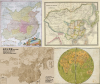
• In April 2014, Angela Merkel gifted to China an ancient map of China, drawn by the famous mapmaker Jean Baptiste Bourguignon d'Anville in the 18th century. The map shown that China's limit is in Hainan.
----
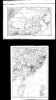
• In response to this map, Sohu.com posted a map of John Nicaragua Dower named "China and Japan" (1844) and some other maps to prove their country's border. However, the maps themselves didn't show any sign of Paracel Islands and stuffs.
Kangxi's Full View Map (Hangyu Quan Lan Tu 康熙全覽圖) has been made for 10 years by the Jesuits under the order of Kangxi Emperor, which was completed in 1717. This map showed Hanan is China's southernmost point.
"Atlas of the Chinese Empire", a work of Edward Stanford in 1908, in partnership with Chinese Imperial Post Offices. Again, China's southernmost point is Hainan.
"Old Forces in New China", a work of George Lanning (principal of Shanghai public school) published at Shanghai, China in 1911, have an attached map that display natural resources of China. The map didn't show any sign of the South Sea islands.
---
Many maps in the book "Geographie de’la Chine" of René Joüon S J published at Shanghai in 1931-1932 clearly shown that China never owns the Paracel & Spartly Islands.
The chinese agressiveness in south china sea only bring tension and hostility toward china, south east asian nation began arming themself preparing for the worse and i believe this is a no win situation for china future if they wanted to be great power replacing the U.S, i hope the chinese realised this.
The chinese agressiveness in south china sea only bring tension and hostility toward china, south east asian nation began arming themself preparing for the worse and i believe this is a no win situation for china future if they wanted to be great power replacing the U.S, i hope the chinese realised this.
i am an indonesian not indians, for us indonesia, china has become a threat when they play rough in south china sea, thats why we are starting building millitary base in south china sea natuna island, and new submarine base in palu strait,
I
i am an indonesian not indians, for us indonesia, china has become a threat when they play rough in south china sea, thats why we are starting building millitary base in south china sea natuna island, and new submarine base in palu strait,
Really? I am new member I saw the flag -ID, thought it's India.
In my opinion, not need to use it as excuse. Those nations need to change their mindset. To USA, China is a threat, because they donimated the area since defeat Spain in the Philippine. But how to say China is a threat to ASEAN nations?
Do you understand USA is a threat to Cuba, Panama? It's senseless, they can just accept the situation.