Galactic Penguin SST
BANNED

- Joined
- Aug 10, 2017
- Messages
- 1,454
- Reaction score
- 1
- Country

- Location

31 Aug 2019; page-112
Safir-1-e-Nahid SLV Disappeared!
Donald J. Trump Verified account @realDonaldTrump 2h
The United States of America was not involved in the catastrophic accident during final launch preparations for the Safir SLV Launch at Semnan Launch Site One in Iran. I wish Iran best wishes and good luck in determining what happened at Site One.
https://twitter.com/realDonaldTrump/status/1167493371973255170

http://web.archive.org/web/20190830194708/https://pbs.twimg.com/media/EDPFB_XWkAY6QWB.jpg ; https://archive.is/WODC7/d0358b58988bc6f8efc912e16b7141259929f652.jpg
▲ 1. Trump wish Iran best wishes and good luck in determining what happened at Site One.
President Trump Tweets Sensitive Surveillance Image of Iran
August 30, 2019
President Trump has tweeted what experts say is almost certainly an image from a classified satellite or drone, showing the aftermath of an accident at an Iranian space facility.
"The United States of America was not involved in the catastrophic accident during final launch preparations for the Safir [Space Launch Vehicle] Launch at Semnan Launch Site One in Iran," the president said in a tweet that accompanied the image on Friday. "I wish Iran best wishes and good luck in determining what happened at Site One."
NPR broke the news of the launch failure on Thursday, using images from commercial satellites that flew over Iran's Imam Khomeini Space Center. Those images showed smoke billowing from the pad. Iran has since acknowledged an accident occurred at the site.
Some of the highest-resolution imagery available commercially comes from the company Maxar, whose WorldView-2 satellite sports 46-centimeter resolution.
But the image shown in the president's tweet appears to be of far better quality, says Ankit Panda, an adjunct senior fellow at the Federation of American Scientists, who specializes in analyzing satellite imagery. "The resolution is amazingly high," says Panda. "I would think it's probably below well below 20 centimeters, which is much higher than anything I've ever seen."
Panda says that the tweet discloses "some pretty amazing capabilities that the public simply wasn't privy to before this."
The Office of the Director of National Intelligence referred questions about the image to the White House, which declined to comment.
The image shows the aftermath of the accident, which experts believe took place while the rocket was being fueled. Clearly visible is the truck used to transport and erect the rocket, and the words "The product of national empowerment," which have been written along the edge of the pad. The picture also shows extensive debris and charring around the pad.
It was not entirely clear where the president's photo came from. Panda believes it was most likely taken by a classified U.S. satellite. But Melissa Hanham, deputy director of the Open Nuclear Network at the One Earth Foundation, believes that the resolution is so high, it may be beyond the physical limits at which satellites can operate. "The atmosphere is thick enough that after somewhere around 11 to 9 centimeters, things get wonky," she says.
That could mean it was taken by a drone or spy plane, though such a vehicle would be violating Iranian airspace. Hanham also says that the European company Airbus has been experimenting with drones that fly so high, they are technically outside the atmosphere and thus operating outside national boundaries. But she says she doesn't know whether the U.S. has such a system.
Glare in the center of the image suggest the image in the tweet was itself a photo of a briefing slide. Panda suggests it could have been displayed on a computer screen in a Sensitive Compartmented Information Facility. It's also possible it was a photo of a piece of paper.
Either way, Panda notes that a small redaction in the upper left-hand corner suggests the intelligence community had cleared the image for release by the president.
But both he and Hanham question whether releasing it was a good idea. "You really risk giving away the way you know things," Hanham says. "That allows people to adapt and hide how they carry out illicit activity."
"These are closely held national secrets," Panda adds. "We don't even share a lot of this kind of imagery with our closest allies." In tweeting it out to the world, Trump is letting Iran know exactly what the U.S. is capable of. He's also letting others know as well, Panda says. "The Russians and the Chinese, you're letting them know that these are the kind of things that the United States has the capability of seeing," he says.
https://www.npr.org/2019/08/30/7559...ve-surveillance-image-of-iran?t=1567199965817
The Safir SLV can not be seen in the image. Damages to the gantry service tower are too extensive to allow another launch attempt in the coming weeks.

https://defence.pk/pdf/threads/iranian-space-program.291303/page-112#post-11738824


")
Another unsuccessful attempt to catch NOOR-1 and QASED R/B, but a bright flare from the same reconnaissance satellite USA-224.
We live in a very small world indeed. What goes around come around, sort of speak.
KH-12-6 (USA-224, NROL-49)
Chapter 9. Orbit and Mission P386
Military Remote-Sensing and Surveillance
For military applications, the main category of US surveillance satellites (or spy satellites, depending on one’s point of view) carry the suggestive name Key Hole (KH). They fall into several series, from KH-1 in 1959 to KH-13, currently operating. For the first few series up to KH-9 in 1986, the basic principle was always the same: a camera took photos, the film was placed in a capsule, and as astonishing as it may seem, the capsule was then thrown back to Earth. A parachute opened at an altitude of 20km and, all being well, an aircraft equipped with a net intercepted the prize in flight (although it could also be picked up by ship in the ocean). Now that the first few series have been declassified, as they say in military circles, we may observe that the success rate was actually very low, with only two successful missions, Discoverer-14 and Discoverer-18, for the 27 satellites of the series KH-1 and -2 (satellites Discoverer-1 to -27). The subsequent series met with more success.
Concerning series KH-11 and -12, results are transmitted via SDS military satellites. It is claimed that images taken by the latest satellites have a resolution of 15cm. However, this raises several questions regarding the influence of atmospheric turbulence, the problem of data accumulation, and so on.
Satellites in the series KH-13 are KH-12 satellites made undetectable to radar and IR sensors, the so-called stealthy satellites, and those in the series 8X will apparently be gigantic telescope satellites called Monstersats, with centimeter resolution, but in fact little is known for certain about these satellites.
Missions were very short for the first KH series, lasting only a few days, but then grew longer, to reach 19 days for KH-4B and 50 days with two capsules for KH-8. Orbits were generally low, with h between 200 and 400 km, near-polar (e.g., Discoverer-35, h = 260km, i = 82°) up to KH-3, then with lower inclination (e.g., KH-4A-14, or Orbis, OPS/3360, hp = 117km, ha = 329km, i = 70°) up to KH-6, and subsequently Sun-synchronous or very high inclination (e.g., KH-7-27, hp = 139km, ha = 375km, i = 117°) up to KH-11, where missions became much longer (which can justify the use of a Sun-synchronous orbit, as we have seen). The first eleven series involved a total of 262 satellites.
For KH-12, the satellites, at 20 tonnes, were sent up for long periods on Sun-synchronous elliptical orbits with hp = 150km, ha ~ 950km, i = ihs ~ 98°. Launches were regularly spaced: KH-12-1 (USA-86 in 1992), KH-12-2 (USA-116 in 1995), KH-12-3 (USA-129, NROL-2 in 1996), KH-12-4 (USA-161, NROL-14 in 2001), KH-12-5 (USA-186, NROL-20 in 2005), KH-12-6 (USA-224, NROL-49 in 2011).
For KH-13, the series known as Misty, it seems that there have been two satellites on a near-circular orbit with h ~ 1,000-3,000 km, i ~ 63°: Misty-1 (USA-53 or AFP-731 launched by STS-36 in 1990) and Misty-2 (USA-144 or EIS-1 in 1999).
“All weather” military observation is carried out by the Lacrosse radar satellites, each with a mass of 20 tonnes. They have circular orbits with medium inclination: Lacrosse-1 (USA-34 or Onyx-1 launched by STS-27 in 1988), h = 440km, i = 57°; the four others, Lacrosse-2 (USA-69 or Onyx-2 in 1991), Lacrosse-3 (USA-133 or Onyx-3 in 1997), Lacrosse-4 (USA-152 or Onyx-4 in 2000), Lacrosse-5 (USA-182 or Onyx-5 in 2005), h = 680km with inclinations alternating between i = 68° and i = 57°.
Handbook of Satellite Orbits: From Kepler to GPS, By Michel Capderou, 2014
https://books.google.com/books/cont...sig=ACfU3U2ArF3SlHejQZWe9GqKjctQ0GgFKg&w=1280
https://books.google.com/books/cont...sig=ACfU3U3-qv4zl5GdtA93uioRR556q7g6rA&w=1280
__________________________
Project history and cost
After the Boeing-led Future Imagery Architecture program failed in 2005, NRO ordered two more KH-11s, including USA-224. Critics worried that each of these "exquisite-class"[2] satellites would cost more than the latest Nimitz-class aircraft carrier (CVN-77), which had a projected procurement cost of US$6.35 billion as of May 2005 (equivalent to approximately $8B in 2019).[3][4] USA-224 – the first of these two – was completed by Lockheed $2 billion under the initial budget estimate, and two years ahead of schedule.[5] USA-224 was launched atop a Delta IV Heavy rocket from Vandenberg AFB Space Launch Complex 6 in California. The launch was conducted by United Launch Alliance, and was the first flight of a Delta IV Heavy from Vandenberg.[6] Liftoff occurred on 20 January 2011 at 21:10:30 UTC.[7] Upon reaching orbit, the satellite received the International Designator 2011-002A.[8]
The satellite began operating 33 days after its predecessor, USA-161, stopped doing its primary mission. This coverage gap was much smaller than originally feared, thanks to USA-224's earlier-than-planned launch and operational changes to extend the lifetime of USA-161.[5]
As the fifteenth KH-11 satellite to be launched, USA-224 is a member of one of the later block configurations occasionally identified as being a separate system. Details of its mission and orbit are classified, but amateur observers have tracked it in low Earth orbit. Shortly after launch it was in an orbit with a perigee of 251 kilometres (156 mi), an apogee of 1,023 kilometres (636 mi) and 97.9 degrees of inclination, typical for an operational KH-11 satellite.[9] By April it was 260 by 987 kilometres (162 by 613 mi) at 97.93 degrees.
On 30 August 2019, President Donald Trump tweeted a classified picture[11] from an intelligence briefing showing the aftermath of an accident that apparently occurred during launch preparations of a Safir-1B-e-Nahid-1 launcher.
NORAD ID: 37348
Int'l Code: 2011-002A
Perigee: 265.4 km
Apogee: 1,032.1 km
Inclination: 97.9 °
Period: 97.6 minutes
Semi major axis: 7019 km
RCS: Unknown
Launch date: January 20, 2011
Source: United States (US)
Launch site: AIR FORCE WESTERN TEST RANGE (AFWTR)
USA 224 is a secret satellite serving the U.S. National Reconnaissance Office.
__________________________
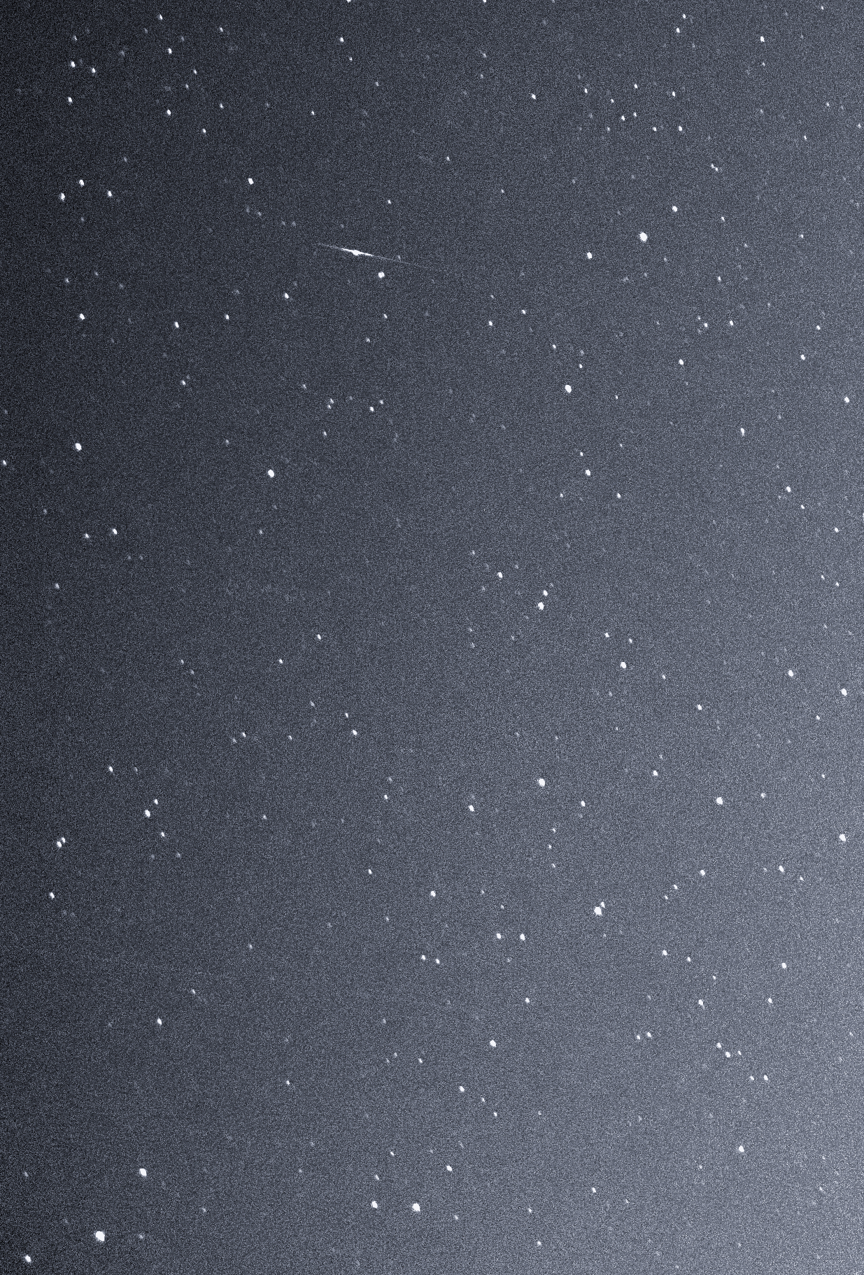
The latest attempt to catch the most elusive Iranian Noor-1 satellite and its mysterious 3rd stage QASED R/B (Arash 24 solid motor) was unsuccessful due to the proximity of the moon, but the frame has easily captured along the much brighter Japanese GOSAT IBUKI Observing Satellite, the most infamous USA-224 reconnaissance satellite, with a very large RCS.
Very high noise level of the camera sensor caused by the current record heatwave (38C degrees in the arctic lately or 17C degrees above the average June level).
Two Line Element Set (TLE):
USA 224
1 37348U 11002A 20166.95993973 0.00003700 00000-0 33551-4 0 02
2 37348 97.9353 278.4452 0546105 264.0600 95.9399 14.76023459 09

http://archive.is/Sjq4J/c597f35e5316c13548f9e59e71bf232ce298deec.jpg ; https://archive.is/Sjq4J/d52fb882266810cc8f5ca908d8ad0d06469ef831/scr.png ; http://web.archive.org/web/20200703231416/https://i.imgur.com/gAIElwj.jpg
▲ 1. USA-224 pass: Magnitude ~4.8 (d), Altitude ~1023 km, Distance ~1471 km, Size ~4 m x 2 m, Angular size ~00.6''.
USA-224 pass caught in Hercules on camera, the first night of this month, showing a bright flare, compared to the lower RCS Japanese GOSAT-IBUKI satellite (in Serpent Caput):
http://archive.vn/fyIol/3ef94c507e8e8a6fe5c95a22be1c0ef84fc21090.jpg ; https://archive.vn/fyIol/3805439f29ff35f3906fd3d7fd89e8ac63d082fe/scr.png ; http://archive.vn/7M6Yp/5a2f08cc3ecf0fce3d290d624b83bdbee21decbc.jpg ; https://archive.vn/7M6Yp/3805439f29ff35f3906fd3d7fd89e8ac63d082fe/scr.png ;
http://web.archive.org/web/20200703232158/https://i.imgur.com/4ZyxcZz.jpg ; http://archive.vn/RpfRF ; http://nova.astrometry.net/user_images/3790696?image=extraction ; http://web.archive.org/web/20200703...er_images/3790696?image=extraction#extraction
▲ 2. USA-224 flare and GOSAT pass as captured on camera.


TAGS:
BGUSAT, Kwangmyongsong-4, GOSAT-2, Yaogan 25A/25B/25C, FIA-Radar 5, KWANGMYONGSONG R/B, IRS P3, Shijian-16, USA-224


