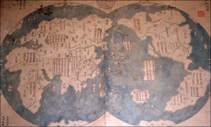
1421 China Map Lays Claims to Americas 


All the Chinese Imperial Maps that I've seen shows that the southernmost extent of China ends at Hainan island. Then I found this ridiculous Mo Yi Tong Chinese map. It says China discovered the Americas before Columbus.
I think China's historical claim over the SCS are based on HOAX. China can't identify specific historical evidence backing Beijing's claims. All of China's historical claim is not recognized in international law.
"Chinese Columbus" Map Likely Fake, Experts Say
"The map shows us the Chinese explorer has been to America years before Columbus," Liu added. "The map also shows us the Chinese understanding of the entire world."
Liu said he realized the significance of the map after reading a book by retired British naval officer Gavin Menzies.
The book, 1421: the Year China Discovered America, argues that Zheng led a fleet of 300 ships to America in the early 15th century to expand Ming China's influence.
Menzies also asserts that Zheng was the first person to circumnavigate the globe and that Chinese settlers established now-vanished colonies throughout the Americas.
What really happened is difficult to prove, because China burned the records of Zheng's expeditions, scholars say.
But academics overwhelmingly dismiss Menzies's claims.
Historical records show that from 1405 to 1433, Zheng led China's imperial Star Fleet on seven epic voyages, but he only reached as far as the southern coast of Africa.
Out of Style
The map, which is reportedly titled a "general chart of the integrated world," is dated 1763 and inscribed with the name Mo Yi-tong.
A lab in New Zealand is radiocarbon-dating a scrap of the map's bamboo paper to determine its age.
But even if the map is shown to be from the 18th century, it would be difficult to verify that it is a copy of an original map produced more than 300 years earlier.
One U.S. map expert says the map does not fit the style of Ming China.
"If this is a 1418 map, it's a whole style very much different than any 1418 map that I've seen," said John Hébert, the chief of the Geography and Map Division at the Library of Congress in Washington, D.C.
Hébert, who has only viewed a small reproduction of the map online, says the map's depiction of the Earth with China not at the center raises a red flag.
"I don't know of any entity at any time, Chinese or otherwise, that did not usually center their cartographic pieces with them[selves] in the middle," he said.
The map's depiction of California as an island also suggests that it could be a copy of a French 17th-century map, Hébert said.
"The other thing that's troubling is the shape of California as an island. That is too much, taken out of what I've seen by French mapping for that [17th] century … [It] almost begs as if we're looking at a 17th-century French world map that had been converted."
"Chinese Columbus" Map Likely Fake, Experts Say
The 1421 Myth Exposed
Chinese admiral Zheng He did not discored the world in 1421
Liu Claim


 you will see how fast Vietnamese SUKHOI can bomb your illegal occupation at Hoang Sa ?


