How to install the app on iOS
Follow along with the video below to see how to install our site as a web app on your home screen.
Note: This feature may not be available in some browsers.
You are using an out of date browser. It may not display this or other websites correctly.
You should upgrade or use an alternative browser.
You should upgrade or use an alternative browser.
China starts "combat ready" patrols in disputed seas
- Thread starter The Great One
- Start date

ComeAtMeBro
FULL MEMBER
New Recruit
- Joined
- Jul 26, 2012
- Messages
- 71
- Reaction score
- 0
All they can do is to bluff
If they want war then do it
If they can nuke us then do it
Stop being a *****
If they are capable to erase everything then prove it
We dont effing care anyway
You are always here in our country
If they want war then do it
If they can nuke us then do it
Stop being a *****
If they are capable to erase everything then prove it
We dont effing care anyway
You are always
here in our country WuMaoCleverbot
FULL MEMBER

- Joined
- May 14, 2012
- Messages
- 470
- Reaction score
- 0
- Country

- Location
In China's view, I believe, the US will not interfered and since China is not going to fire the first shot, any skirmish will have to instigated by VN or PI. If such scenario arises, China will not hesitate to eliminate their forces in lighting speed because she is the defender and has world opinions on her side..
New Chinese tactic to get the ownership of SCS:
Increase use of disguised fishing fleets and other supposedly civilian activities to provoke an incident.
It's a bit tough for PLAN to expel a few under-equipped "squatters", isn't it?
Oh, I know: the Chinese admirals were expecting the "squatters" to shoot at your fishermen.
China's position, for years, was clear for the members that are involved in the SCS disputes, " come to the table and we'll talk one on one and find solutions peacefully", meaning joint developments. .
China wants bilateral talks with Vietnam, Malaysia, the Philippines and Brunei but this is only acceptable if she has an equally valid reasons for claiming these islands.
Vietnam, Malaysia, the Philippines and Brunei uses international law for laying their respective claims while the Chinese are using it's unverified old dotted map and history plus guns/military and money/economy to lay her claim.
Bilateral talks would only be acceptable between the ASEAN states because they all use international law as against China who wouldn't submit itself before an international court because she know that she has no legal basis for her claim.
WuMaoCleverbot
FULL MEMBER
- Joined
- May 14, 2012
- Messages
- 470
- Reaction score
- 0
- Country
- Location
Another example of China's "MINE IS MINE, YOURS IS MINE AND WE SHARE." China should stop poaching in Philippine waters.
And you Filipino big mouths keep wondering why China is doing all this.
Best Answer: Chinese are GREEDY. China have 3 trillion in Cash Reserve but China is still so greedy and trying to steal fish, sea and land from its poor neighbors.
WuMaoCleverbot
FULL MEMBER
- Joined
- May 14, 2012
- Messages
- 470
- Reaction score
- 0
- Country
- Location
The fact: our claim is based on facts and international law, China's claim is based on propaganda.
1. Fact Number One: the Philippines has exercised both effective occupation and effective jurisdiction over Bajo de Masinloc since its independence. In 1957, the Philippine government conducted an oceanographic survey of the area and together with the US Navy force based in then U.S. Naval Base Subic Bay in Zambales, used the area as an impact range for defense purposes. An 8.3 meter high flag pole flying a Philippine flag was raised in 1965. A small lighthouse was also built and operated the same year.[29] In 1992, the Philippine Navy rehabilitated the lighthouse and reported it to the International Maritime Organization for publication in the List of Lights
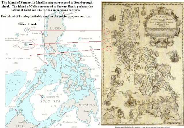
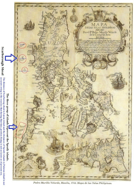
2. Fact Number Two: We have a 1734 Murillo Map showing Scarborough and Spratlys are part of Philippine territory.
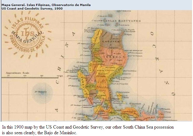
3. Fact Number Three: Scarborough shoal is in fact included in the Treaty of Paris. The Mapa General, Islas Filipinas, Observatorio de Manila by the US Coast and Geodetic Survey, also included Bajo de Masinloc as part of the Philippines.
4. Fact Number Four: Scarborough shoal and the Spratlys are within the EEZ of the Philippines.
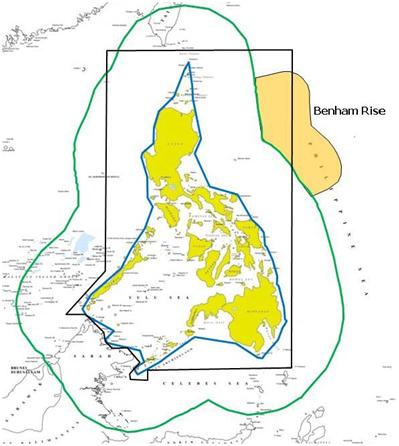
The black-lines show the 1898 Treaty of Paris territorial limits; the blue lines are the baselines under RA 3046, as amended by RA 5466; and the green lines are the exclusive economic zones (EEZ) under the UN Convention on the Law of the Sea (UNCLOS). Source: National Mapping and Resource Information Authority

5. Fact Number Five: Scarborough Shoal entered Philippine jurisprudence in 1916 when the Philippine Supreme Court decided a case involving a shipwreck there. The shipwreck predates China’s 1935 claim.
The lawsuit decided by the Philippines’ top court in 1916 – led by Filipino Chief Justice Cayetano Arellano – “is clear evidence that we were exercising jurisdiction over the shoal and incidents on it during the American colonial period” in the Philippines.”
“This case is proof we are the ones responsible when it comes to shipwrecks on Scarborough,”
Here’s the link to the actual SC decision that shows the Philippines’ jurisdictional claim on Scarborough over that of China:
G.R. No. L-10051
6. Fact Number Six: As early as 1734, we Filipinos already named Scarborough shoal as Panacot. It is only in 1935 when Chinese official records state that the shoal – which it mentions by its popular western name “Scarborough Shoal” – was part of its “Zhongsha Islands”. While the Chinese baptized the shoal a Chinese name only in 1947. So who's the one who named Scarborough shoal FIRST??? ANSWER: PHILIPPINES

Official Position of the Philippines over Scarborough shoal and its surrounding waters:
The basis of Philippine sovereignty and jurisdiction over the rock features of Bajo de Masinloc is not premised on the cession by Spain of the Philippine archipelago to the United States under the Treaty of Paris. The matter that the rock features of Bajo de Masinloc are not included or within the limits of the Treaty of Paris as alleged by China is therefore immaterial and of no consequence.
Philippine sovereignty and jurisdiction over the rocks of Bajo de Masinloc is likewise not premised on proximity or the fact that the rocks are within its 200-NM EEZ or CS under the UN Convention on the Law of the Sea (UNCLOS). Although the Philippines necessarily exercise sovereign rights over its EEZ and CS, nonetheless, the reason why the rock features of Bajo de Masinloc are Philippine territories is anchored on other principles of public international law.
As decided in a number of cases by international courts or tribunals, most notably the Palmas Island Case, a modality for acquiring territorial ownership over a piece of real estate is effective exercise of jurisdiction. Indeed, in that particular case, sovereignty over the Palmas Island was adjudged in favor of the Netherlands on the basis of “effective exercise of jurisdiction,” although the said island may have been historically discovered by Spain and historically ceded to the U.S. in the Treaty of Paris.
In the case of Bajo de Masinloc, the Philippines has exercised both effective occupation and effective jurisdiction over Bajo de Masinloc since its independence.
The name Bajo de Masinloc (translated as “under Masinloc”") itself identifies the shoal as a particular political subdivision of the Philippine province of Zambales, known as Masinloc.
itself identifies the shoal as a particular political subdivision of the Philippine province of Zambales, known as Masinloc.
One of the earliest known and most accurate maps of the area, named Carta Hydrographical y Chorographica De Las Yslas Filipinas by Fr. Pedro Murillo Velarde, SJ, and published in 1734, included Bajo de Masinloc as part of Zambales.
The name Bajo de Masinloc was a name given to the shoal by the Spanish colonizers. In 1792, another map drawn by the Alejandro Malaspina expedition and published in 1808 in Madrid, Spain, also showed Bajo de Masinloc as part of Philippine territory. This map showed the route of the Malaspina expedition to and around the shoal. It was reproduced in the Atlas of the 1939 Philippine Census.
The Mapa General, Islas Filipinas, Observatorio de Manila, published in 1990 by the U.S. Coast and Geodetic Survey, also included Bajo de Masinloc as part of the Philippines.
Philippine flags have been erected on some of the islets of the shoal, including a flag raised on an 8.3-meter high flagpole in 1965 and another Philippine flag raised by Congressmen Roque Ablan and Jose Yap in 1997. In 1965, the Philippines also built and operated a small lighthouse in one of the islets in the shoal. In 1992, the Philippine Navy rehabilitated the lighthouse and reported it to the International Maritime Organization for publication in the List of Lights (currently, this lighthouse is not operational).
Bajo de Masinloc was also used as an impact range by Philippine and U.S. Naval Forces stationed in Subic Bay in Zambales for defense purposes. The Philippines Department of Environment and Natural Resources, together with the University of the Philippines, has also been conducting scientific, topographic, and marine studies in the shoal. Filipino fishermen have always considered it as their fishing grounds, owing to their proximity to the coastal towns and areas of Southwest Luzon.
In 2009, when the Philippines passed an amended Archipelagic Baselines Law that is fully consistent with the Law of the Sea, Bajo de Masinloc’s was classified under the “Regime of Islands” consistent with the Law of the Sea.
Section 2. The baseline in the following areas over which the Philippines likewise exercises sovereignty and jurisdiction shall be determined as “Regime of Islands” under the Republic of the Philippines consistent with Article 121 of the United Nations Convention on the Law of the Sea (UNCLOS):
a) The Kalayaan Island Group as constituted under Presidential Decree No. 1596; and
b) Bajo de Masinloc, also known as Scarborough Shoal.
China refused our offer of international arbitration, that itself is like an admission that its nine dash will not survive the ICJ.
The Philippines has already provided the world with the information they need to judge for themselves who the true owners of Scarborough is. And many countries have voiced their support to the Philippines because they believe that the Philippines is right.
But how about China? What evidence has she shown? Nothing!
1. Fact Number One: the Philippines has exercised both effective occupation and effective jurisdiction over Bajo de Masinloc since its independence. In 1957, the Philippine government conducted an oceanographic survey of the area and together with the US Navy force based in then U.S. Naval Base Subic Bay in Zambales, used the area as an impact range for defense purposes. An 8.3 meter high flag pole flying a Philippine flag was raised in 1965. A small lighthouse was also built and operated the same year.[29] In 1992, the Philippine Navy rehabilitated the lighthouse and reported it to the International Maritime Organization for publication in the List of Lights
2. Fact Number Two: We have a 1734 Murillo Map showing Scarborough and Spratlys are part of Philippine territory.
3. Fact Number Three: Scarborough shoal is in fact included in the Treaty of Paris. The Mapa General, Islas Filipinas, Observatorio de Manila by the US Coast and Geodetic Survey, also included Bajo de Masinloc as part of the Philippines.
4. Fact Number Four: Scarborough shoal and the Spratlys are within the EEZ of the Philippines.
The black-lines show the 1898 Treaty of Paris territorial limits; the blue lines are the baselines under RA 3046, as amended by RA 5466; and the green lines are the exclusive economic zones (EEZ) under the UN Convention on the Law of the Sea (UNCLOS). Source: National Mapping and Resource Information Authority
5. Fact Number Five: Scarborough Shoal entered Philippine jurisprudence in 1916 when the Philippine Supreme Court decided a case involving a shipwreck there. The shipwreck predates China’s 1935 claim.
The lawsuit decided by the Philippines’ top court in 1916 – led by Filipino Chief Justice Cayetano Arellano – “is clear evidence that we were exercising jurisdiction over the shoal and incidents on it during the American colonial period” in the Philippines.”
“This case is proof we are the ones responsible when it comes to shipwrecks on Scarborough,”
Here’s the link to the actual SC decision that shows the Philippines’ jurisdictional claim on Scarborough over that of China:
G.R. No. L-10051
6. Fact Number Six: As early as 1734, we Filipinos already named Scarborough shoal as Panacot. It is only in 1935 when Chinese official records state that the shoal – which it mentions by its popular western name “Scarborough Shoal” – was part of its “Zhongsha Islands”. While the Chinese baptized the shoal a Chinese name only in 1947. So who's the one who named Scarborough shoal FIRST??? ANSWER: PHILIPPINES
Official Position of the Philippines over Scarborough shoal and its surrounding waters:
The basis of Philippine sovereignty and jurisdiction over the rock features of Bajo de Masinloc is not premised on the cession by Spain of the Philippine archipelago to the United States under the Treaty of Paris. The matter that the rock features of Bajo de Masinloc are not included or within the limits of the Treaty of Paris as alleged by China is therefore immaterial and of no consequence.
Philippine sovereignty and jurisdiction over the rocks of Bajo de Masinloc is likewise not premised on proximity or the fact that the rocks are within its 200-NM EEZ or CS under the UN Convention on the Law of the Sea (UNCLOS). Although the Philippines necessarily exercise sovereign rights over its EEZ and CS, nonetheless, the reason why the rock features of Bajo de Masinloc are Philippine territories is anchored on other principles of public international law.
As decided in a number of cases by international courts or tribunals, most notably the Palmas Island Case, a modality for acquiring territorial ownership over a piece of real estate is effective exercise of jurisdiction. Indeed, in that particular case, sovereignty over the Palmas Island was adjudged in favor of the Netherlands on the basis of “effective exercise of jurisdiction,” although the said island may have been historically discovered by Spain and historically ceded to the U.S. in the Treaty of Paris.
In the case of Bajo de Masinloc, the Philippines has exercised both effective occupation and effective jurisdiction over Bajo de Masinloc since its independence.
The name Bajo de Masinloc (translated as “under Masinloc”
itself identifies the shoal as a particular political subdivision of the Philippine province of Zambales, known as Masinloc.One of the earliest known and most accurate maps of the area, named Carta Hydrographical y Chorographica De Las Yslas Filipinas by Fr. Pedro Murillo Velarde, SJ, and published in 1734, included Bajo de Masinloc as part of Zambales.
The name Bajo de Masinloc was a name given to the shoal by the Spanish colonizers. In 1792, another map drawn by the Alejandro Malaspina expedition and published in 1808 in Madrid, Spain, also showed Bajo de Masinloc as part of Philippine territory. This map showed the route of the Malaspina expedition to and around the shoal. It was reproduced in the Atlas of the 1939 Philippine Census.
The Mapa General, Islas Filipinas, Observatorio de Manila, published in 1990 by the U.S. Coast and Geodetic Survey, also included Bajo de Masinloc as part of the Philippines.
Philippine flags have been erected on some of the islets of the shoal, including a flag raised on an 8.3-meter high flagpole in 1965 and another Philippine flag raised by Congressmen Roque Ablan and Jose Yap in 1997. In 1965, the Philippines also built and operated a small lighthouse in one of the islets in the shoal. In 1992, the Philippine Navy rehabilitated the lighthouse and reported it to the International Maritime Organization for publication in the List of Lights (currently, this lighthouse is not operational).
Bajo de Masinloc was also used as an impact range by Philippine and U.S. Naval Forces stationed in Subic Bay in Zambales for defense purposes. The Philippines Department of Environment and Natural Resources, together with the University of the Philippines, has also been conducting scientific, topographic, and marine studies in the shoal. Filipino fishermen have always considered it as their fishing grounds, owing to their proximity to the coastal towns and areas of Southwest Luzon.
In 2009, when the Philippines passed an amended Archipelagic Baselines Law that is fully consistent with the Law of the Sea, Bajo de Masinloc’s was classified under the “Regime of Islands” consistent with the Law of the Sea.
Section 2. The baseline in the following areas over which the Philippines likewise exercises sovereignty and jurisdiction shall be determined as “Regime of Islands” under the Republic of the Philippines consistent with Article 121 of the United Nations Convention on the Law of the Sea (UNCLOS):
a) The Kalayaan Island Group as constituted under Presidential Decree No. 1596; and
b) Bajo de Masinloc, also known as Scarborough Shoal.
China refused our offer of international arbitration, that itself is like an admission that its nine dash will not survive the ICJ.
The Philippines has already provided the world with the information they need to judge for themselves who the true owners of Scarborough is. And many countries have voiced their support to the Philippines because they believe that the Philippines is right.
But how about China? What evidence has she shown? Nothing!
WuMaoCleverbot
FULL MEMBER
- Joined
- May 14, 2012
- Messages
- 470
- Reaction score
- 0
- Country
- Location
Found this:
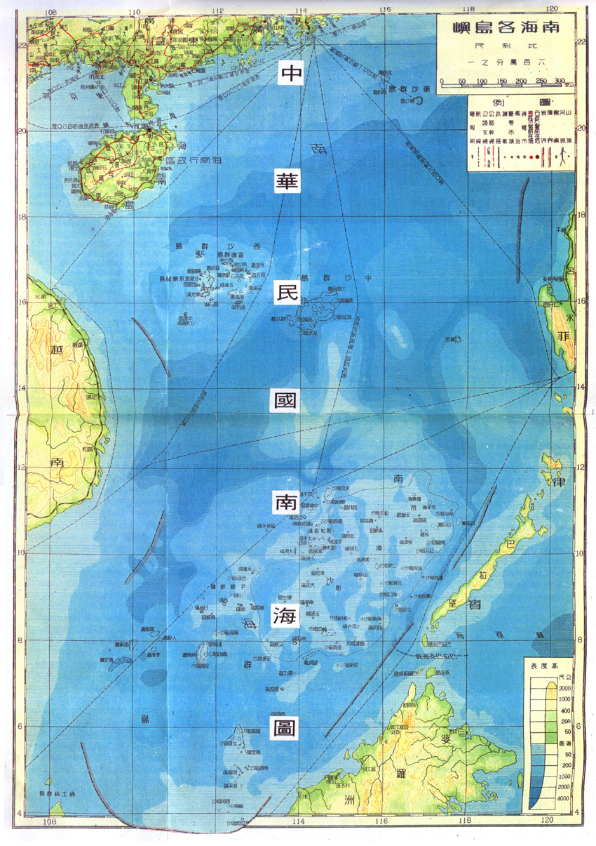
The SCS dispute started from this Chinese map.I suppose the one who created the map was an expansionist. His imagination really caused a lot of troubles.
Most probable origin of 9-dash line claim:
The second world war finished in 1945. As the winners in the second world war, US UK France USSR had right to ''divide'' the world again. However, China did not have this right since the contribution of China to the victory of the second world war was VERY VERY SMALL. Going back to the Chinese expansionist. This guy had responsibility to create the map of republic of China. He thought that China was also a winner and it was unfair for republic of China if China did not get anything. He decided himself to draw above map according to his imagination. He thought that the sea in the south of China should be considered as a bonus for republic of China. His idea was approved by other Chinese expansionists. In 1946, this map was published.
Roosevelt, Stalin and Churchill would do fine without Chiang Kai Shek. They were always the big 3, not 4. While history admires the courage of the Chinese fighting the invading Japanese, lets admit that the number of Chinese soldiers who died is vastly incomparable to the ratio of Japanese soldiers who lost their lives in the process. Bottomline, despite the Chinese outnumbering the Japanese soldiers 10 to 1, you still got defeated by the axis Japanese if it weren't the help of US, Britain and Russia. Wheres the greatness in that?
Is that why Roosevelt, Churchill and Starlin included China in its exclusive permanent members of the
United Nations Security Council. Learn some history first before you rant here.
The fact: our claim is based on facts and international law, China's claim is based on propaganda.
1. Fact Number One: the Philippines has exercised both effective occupation and effective jurisdiction over Bajo de Masinloc since its independence. In 1957, the Philippine government conducted an oceanographic survey of the area and together with the US Navy force based in then U.S. Naval Base Subic Bay in Zambales, used the area as an impact range for defense purposes. An 8.3 meter high flag pole flying a Philippine flag was raised in 1965. A small lighthouse was also built and operated the same year.[29] In 1992, the Philippine Navy rehabilitated the lighthouse and reported it to the International Maritime Organization for publication in the List of Lights
2. Fact Number Two: We have a 1734 Murillo Map showing Scarborough and Spratlys are part of Philippine territory.
3. Fact Number Three: Scarborough shoal is in fact included in the Treaty of Paris. The Mapa General, Islas Filipinas, Observatorio de Manila by the US Coast and Geodetic Survey, also included Bajo de Masinloc as part of the Philippines.
4. Fact Number Four: Scarborough shoal and the Spratlys are within the EEZ of the Philippines.
The black-lines show the 1898 Treaty of Paris territorial limits; the blue lines are the baselines under RA 3046, as amended by RA 5466; and the green lines are the exclusive economic zones (EEZ) under the UN Convention on the Law of the Sea (UNCLOS). Source: National Mapping and Resource Information Authority
5. Fact Number Five: Scarborough Shoal entered Philippine jurisprudence in 1916 when the Philippine Supreme Court decided a case involving a shipwreck there. The shipwreck predates China’s 1935 claim.
The lawsuit decided by the Philippines’ top court in 1916 – led by Filipino Chief Justice Cayetano Arellano – “is clear evidence that we were exercising jurisdiction over the shoal and incidents on it during the American colonial period” in the Philippines.”
“This case is proof we are the ones responsible when it comes to shipwrecks on Scarborough,”
Here’s the link to the actual SC decision that shows the Philippines’ jurisdictional claim on Scarborough over that of China:
G.R. No. L-10051
6. Fact Number Six: As early as 1734, we Filipinos already named Scarborough shoal as Panacot. It is only in 1935 when Chinese official records state that the shoal – which it mentions by its popular western name “Scarborough Shoal” – was part of its “Zhongsha Islands”. While the Chinese baptized the shoal a Chinese name only in 1947. So who's the one who named Scarborough shoal FIRST??? ANSWER: PHILIPPINES
Official Position of the Philippines over Scarborough shoal and its surrounding waters:
The basis of Philippine sovereignty and jurisdiction over the rock features of Bajo de Masinloc is not premised on the cession by Spain of the Philippine archipelago to the United States under the Treaty of Paris. The matter that the rock features of Bajo de Masinloc are not included or within the limits of the Treaty of Paris as alleged by China is therefore immaterial and of no consequence.
Philippine sovereignty and jurisdiction over the rocks of Bajo de Masinloc is likewise not premised on proximity or the fact that the rocks are within its 200-NM EEZ or CS under the UN Convention on the Law of the Sea (UNCLOS). Although the Philippines necessarily exercise sovereign rights over its EEZ and CS, nonetheless, the reason why the rock features of Bajo de Masinloc are Philippine territories is anchored on other principles of public international law.
As decided in a number of cases by international courts or tribunals, most notably the Palmas Island Case, a modality for acquiring territorial ownership over a piece of real estate is effective exercise of jurisdiction. Indeed, in that particular case, sovereignty over the Palmas Island was adjudged in favor of the Netherlands on the basis of “effective exercise of jurisdiction,” although the said island may have been historically discovered by Spain and historically ceded to the U.S. in the Treaty of Paris.
In the case of Bajo de Masinloc, the Philippines has exercised both effective occupation and effective jurisdiction over Bajo de Masinloc since its independence.
The name Bajo de Masinloc (translated as “under Masinloc”
One of the earliest known and most accurate maps of the area, named Carta Hydrographical y Chorographica De Las Yslas Filipinas by Fr. Pedro Murillo Velarde, SJ, and published in 1734, included Bajo de Masinloc as part of Zambales.
The name Bajo de Masinloc was a name given to the shoal by the Spanish colonizers. In 1792, another map drawn by the Alejandro Malaspina expedition and published in 1808 in Madrid, Spain, also showed Bajo de Masinloc as part of Philippine territory. This map showed the route of the Malaspina expedition to and around the shoal. It was reproduced in the Atlas of the 1939 Philippine Census.
The Mapa General, Islas Filipinas, Observatorio de Manila, published in 1990 by the U.S. Coast and Geodetic Survey, also included Bajo de Masinloc as part of the Philippines.
Philippine flags have been erected on some of the islets of the shoal, including a flag raised on an 8.3-meter high flagpole in 1965 and another Philippine flag raised by Congressmen Roque Ablan and Jose Yap in 1997. In 1965, the Philippines also built and operated a small lighthouse in one of the islets in the shoal. In 1992, the Philippine Navy rehabilitated the lighthouse and reported it to the International Maritime Organization for publication in the List of Lights (currently, this lighthouse is not operational).
Bajo de Masinloc was also used as an impact range by Philippine and U.S. Naval Forces stationed in Subic Bay in Zambales for defense purposes. The Philippines Department of Environment and Natural Resources, together with the University of the Philippines, has also been conducting scientific, topographic, and marine studies in the shoal. Filipino fishermen have always considered it as their fishing grounds, owing to their proximity to the coastal towns and areas of Southwest Luzon.
In 2009, when the Philippines passed an amended Archipelagic Baselines Law that is fully consistent with the Law of the Sea, Bajo de Masinloc’s was classified under the “Regime of Islands” consistent with the Law of the Sea.
Section 2. The baseline in the following areas over which the Philippines likewise exercises sovereignty and jurisdiction shall be determined as “Regime of Islands” under the Republic of the Philippines consistent with Article 121 of the United Nations Convention on the Law of the Sea (UNCLOS):
a) The Kalayaan Island Group as constituted under Presidential Decree No. 1596; and
b) Bajo de Masinloc, also known as Scarborough Shoal.
China refused our offer of international arbitration, that itself is like an admission that its nine dash will not survive the ICJ.
The Philippines has already provided the world with the information they need to judge for themselves who the true owners of Scarborough is. And many countries have voiced their support to the Philippines because they believe that the Philippines is right.
But how about China? What evidence has she shown? Nothing!
While I think that nine *** map is kind of too much, but the claim China has over those islands are as strong as the next one if not stronger.
China’s South China Sea jurisdictional claims: when politics and law collideChina’s South China Sea jurisdictional claims: when politics and law collide
July 29th, 2012
Author: Sourabh Gupta, Samuels International
A running thread through the tensions at various Southeast Asian regional forums over the past four summers has been the uncertainty and insecurity generated by China’s jurisdictional claims in the South China Sea.
Legally, China claims sovereignty over the disputed islands and adjacent waters in the Sea and sovereign rights over relevant waters as well as the seabed and subsoil thereof — a claim in accordance with Law of the Seas (LOS) norms.
But operationally, China’s oceanic law enforcement agencies have unilaterally, and at times forcefully, enforced their writ across the more expansive political perimeter bounded by the ‘nine-dashed line’.
Plainly, these legal and political claims overlap but do not coincide. However, endless dwelling on the supposedly impenetrable logic of the nine-dashed line’s extremity is side-tracking attention from what ought to be the central premise of this issue: that China’s claim to the primary land elements lying within the nine-dashed line — the Spratlys and the Paracels — is markedly superior to those of its rival claimants.
Alone among claimants, China is capable of coupling ‘continuous and effective occupation’ of the islands, islets and reefs with a robust modern international law-based claim backed by relevant multilateral and bilateral instruments.
In 1952, Japan renounced all right, title and claim to the Spratly and Paracel Islands to the Republic of China (Taiwan), by way of Article 2 of the bilateral Japan–Taiwan Treaty of Taipei. This treaty followed — and referenced — the territorial renunciations of the Islands by Japan under the 1951 San Francisco Peace Treaty, which had not identified the beneficiary at the time — a treaty that was ratified by both the Philippine and (South) Vietnamese governments. And although neither country is bound by provisions in the bilateral Japan–Taiwan treaty, neither can produce a Spratlys/Paracels cession or reversion clause in their own bilateral treaties with Japan. Rather, their claims are supplementarily based on historical cartography in the case of Vietnam or, for the Philippines, ‘historical discovery’ that is (incredibly) of a post-World War II vintage!
At the end of the day, ultimate title cannot be said to rest with any one party so long as a territorial claim is not resolved by way of a binding instrument between claimant states. At best, there are better claims and less-better claims to the territory in question. But given China’s law-based claim is superior to that of rival claimants, why does it persist with the infamous nine-dashed line?
As the successor government of Taiwan, the mundane reason is that Beijing is proceeding from the claim line that it inherited from the Chiang Kai-shek regime as the baseline for negotiation and compromise in an open territorial dispute. Beijing’s approach to negotiating its Himalayan boundary dispute with India is no different in this regard. But the technical reason is more complicated. Were China to submit an LOS-compliant claim to its outer continental shelf limits in the South China Sea, the UN Commission on the Limits of the Continental Shelf (CLCS), tasked with examining its validity, would almost certainly strike down parts of the submission.
The CLCS appears on track to de-recognising Japan’s claim that the two high-tide elevations — totally the size of five tatami mats — within the Okinotori atolls in the Pacific are in fact ‘islands’ capable of generating an EEZ (that is ironically larger in dimension than the land mass of Japan itself). By the same reasoning, many of the high-tide elevations under Beijing’s control in the South China Sea would be found to be mere ‘rocks’. Although CLCS findings are non-enforceable, it would dent China’s case to certain disputed resource-rich zones within the Sea — hence its preference for the nine-dashed line.
The foremost motive for the nine-dashed line’s persistence is its intertwined character with the highly politicised, deterrence-based model of territorial dispute management that Beijing favours.
Territorial jurisdiction issues have never been treated as mere cartographic detail: they are tied to a larger political calculus of stability and good neighbourliness. In its maritime dimension, joint development of commonly held resources has been the established mode to implement this principle. Here, Manila’s misjudgement in abrogating its joint seismic study agreement with Vietnam and China in 2008 (compounding the error by unilaterally issuing exploration licenses within a disputed section of the study area) has been the principal cause of the swift deterioration in bilateral ties with China.
Furthermore, territorial settlements have never been concluded under duress, and China’s rulers calibrate their approach between a hard-line and a flexible one to suit the strategic circumstances at hand. The nine-dashed line has conveniently served as a hard-line expedient that Beijing’s competing maritime bureaucracies are not shy to lever to signal displeasure to other claimants.
So what are the enabling circumstances that would motivate China to set the nine-dashed line aside and adhere to best international practice in issuing forth maritime jurisdictional claims? Beijing has previously been willing to soften its inflated ‘natural prolongation’ principle with Korea and Japan to pursue fisheries and (in-principle) joint resource development, and the 2000 Gulf of Tonkin maritime delimitation agreement with Vietnam too was firmly in keeping with the highest international practices.
Given the fast-paced development of international maritime law, which is accentuating the gap between political calculus-based and rules-based orders at sea, it is in China’s self-interest to submit an LOS-compliant claim to its outer continental-shelf limits in the South China Sea. Beijing’s gains in goodwill earned will far outweigh the territory, and resources, relinquished. It might also allow China leeway to subsequently initiate a region-wide conversation on introducing limits to objectionable, threat-based activities in EEZs by foreign navies, under the guise of navigational freedoms.
Sourabh Gupta is Senior Research Associate at Samuels International Associates, Washington DC, and a 2012 EAF Distinguished Fellow.
The mean point here is "At the end of the day, ultimate title cannot be said to rest with any one party so long as a territorial claim is not resolved by way of a binding instrument between claimant states. At best, there are better claims and less-better claims to the territory in question." That is why everyone in the international community consider spartly and paracel as disputed territories rather than accepting anyone's claim over them.
ahfatzia
SENIOR MEMBER

- Joined
- Feb 22, 2012
- Messages
- 2,521
- Reaction score
- 0
Thanks for the NYT map, it gives a very clear picture on the dispute area in SCS and you can count every country's occupied islands. A few interest observations I want to point out here:
1) Even though China claims the entire SCS but she doesn't have any possessions within Brunei and Malaysia claimed territories, so it's unlikely for them to antagonize China while all these is going on.
2) Aside from Huangyan Islands the actual big dispute is between Philippines and Vietnam because the latter occupies 18 islands in their overlap claimed territories. Is there any reason as to why the Filipino boys here take their grievances against the Chinese rather than to the Viets? And how long can this buddy buddy camaraderie atmosphere can last in this forum as there is already signs of breaking ups?
3) There is at least three lumps of island groups where the Chinese and the Vietnamese possessions are very close together. Hmm, I anticipate flare ups in the near future and wonder how prepare the Viets are.
WuMaoCleverbot
FULL MEMBER
- Joined
- May 14, 2012
- Messages
- 470
- Reaction score
- 0
- Country
- Location
Is that why Roosevelt, Churchill and Starlin included China in its exclusive permanent members of the
United Nations Security Council. Learn some history first before you rant here..
.
Do you know that despite opposition from other leaders, especially Winston Churchill, China became a permanent member of the Security Council from its creation in 1945 just because President Franklin Roosevelt facilitated Chiang Kai Shek Republic of China admission to the UN Security Council???
While I think that nine *** map is kind of too much, but the claim China has over those islands are as strong as the next one if not stronger.
.
China has the weakest claim. China's claims to sovereignty have no basis. Ancient maps, traditional fishing grounds, and old explorers are not enough to establish sovereignty. Both China and Philippines signed UNCLOS, and the areas in question fall within Philippines Exclusive Economic Zone.
The mean point here is "At the end of the day, ultimate title cannot be said to rest with any one party so long as a territorial claim is not resolved by way of a binding instrument between claimant states. At best, there are better claims and less-better claims to the territory in question." That is why everyone in the international community consider spartly and paracel as disputed territories rather than accepting anyone's claim over them.
.
We do not share your view that China is a claimant country...In our eyes, China is more like a professional land grabber and NOT a claimant country. Remember, China to this date has not shown any evidence to back up her claims. The world has not seen and examined her so called 1279 map. China have failed to identify specific historical evidence backing Beijing's claims that it owns disputed islands in the West Philippine Sea.
WuMaoCleverbot
FULL MEMBER
- Joined
- May 14, 2012
- Messages
- 470
- Reaction score
- 0
- Country
- Location
Is there any reason as to why the Filipino boys here take their grievances against the Chinese rather than to the Viets?
China is bullying us and has threatened war with the Philippines. That's why sinophobia is rising in the Philippines.
Remember this guy:
An Outraged Chinese General( Chinese Major General Luo Yuan}Tells The Philippines It's Their 'Last Chance'

The three countries have been going back-and-forth over rights to supposed oil and gas reserves throughout the region, with Malaysia, Taiwan and Brunei also attempting to lay claim on the deposits.
There were hopes the issue would be brought closer to resolution during the recent Association of Southeast Asian Nations summit in Cambodia, but that get-together seems to have had exactly the opposite effect.
Brian Spegele at the WSJ's China Real Time Reports that Chinese Major General Luo Yuan left the summit, got back to China and penned a warning to the island nation that he published in the Global Times newspaper.
In it, he warns the Philippines that it's facing its "last chance" to reach an agreement on the resource laden South China Sea and the Spratly Islands.
In one swift move Luo brought renewed attention on what Spegele calls the "region’s hottest potential military flashpoint."
Always refreshingly outspoken, Luo didn't stop there and continued by saying "The biggest miscalculation of the Philippines is that it has misestimated the strength and willpower of China to defend its territorial integrity.”
Maybe Luo was still smarting an unknown slight at the Cambodia conference because he he also accuses the Philippines of high-jacking the Asian Nations summit, and declares Manilla's "continuing provocations" destined to fail.
Spegele points out the sharp words from such a senior military commander come at a difficult time, when China is focused on tensions within the Korean peninsula, and burdened by problems facing its only Middle Eastern ally Iran.
If the war between China and Philippines happens, America will come to the defense of our territory. China will definitely lose. I guess this Chinese Major General Luo Yuan will regret his words. Each family in China has only a single child. Does this Chinese general want Chinese families lose their children in order to invade other countries? It will be an very unjust war. I suppose many Filipino guys in this forum lets KNOWLEDGE, EVIDENCES of sovereignty, MAPS, DOCUMENTS ... do the TALKING since they want to avoid a WAR. But it does not mean that they are afraid of war if you look again at Filipino history. Remember Bataan and Corregidor. Remember Battle of Yultong...Filipinos kicked China's ***.
Battle of Yultong
The Battle of Yultong was the largest battle that Philippine troops participated in during the Korean War and is widely known as their bravest stand during the conflict.
The battle took place 5 kilometers north of Yeoncheon amid the Chinese Spring Offensive. Every single Filipino, including cooks and drivers, took up weapons to fight even though they were outnumbered 17 to 1. They successfully held off the Chinese, allowing the retreat of friendly forces, and they held their position until they were given the order for their own retreat.
Casualties and losses:
China 500 killed 2 captured
Philippines 12 killed 38 wounded 6 missing
The Battle of Yultong bridge was another real proof that Filipinos are real fighters.
We also remember this:

This is ironic because this is what Bruce Lee hated and even used as a plot in his movies...
Obviously you copied those sentence from wikipedia, then why don't you copied the complete paragraphy here???Do you know that despite opposition from other leaders, especially Winston Churchill, China became a permanent member of the Security Council from its creation in 1945 because President Franklin Roosevelt facilitated Chiang Kai Shek Republic of China admission to the UN Security Council???
China and the United Nations - Wikipedia, the free encyclopediaAs one of the "Big Four" allies in World War II (China, the Soviet Union, the United Kingdom, and the United States), the Republic of China (ROC) was one of the founding members of the United Nations. President Franklin Roosevelt had acknowledged China's war effort in World War II and stated his desire to allow China to "play its proper role in maintaining peace and prosperity" in the world, even though China was not socially influential or militarily strong.[1][2] Thus, despite opposition from other leaders, especially Winston Churchill,[3] China became a permanent member of the Security Council from its creation in 1945.[4] In 1949, the Communist Party of China seized power in mainland China and declared the People's Republic of China (PRC), claiming to have replaced the ROC as the sole legitimate government of China and the ROC government retreated to the island of Taiwan (which it gained control of in 1945 at the end of WWII), Quemoy Island, and the Matsu Islands.
So even from this source, it is stated China as one of the "big four", that even excludes France"
From your wiki sourceChina has the weakest claim. China's claims to sovereignty have no basis. Ancient maps, traditional fishing grounds, and old explorers are not enough to establish sovereignty. Both China and Philippines signed UNCLOS, and the areas in question fall within Philippines Exclusive Economic Zone.
http://en.wikipedia.org/wiki/Territorial_disputes_in_the_South_China_SeaFollowing World War II, Chinese exercise of sovereignty over the South China Sea region, the Spratly and Paracel archipelago and their adjacent waters was relatively uncontested. The United States and Spain had not included the Spratly Islands within the territorial limits of the Philippines in the Washington Treaty of 1898 and the Treaty of Paris in 1900. This understanding was reinforced by the 1973 Philippine Constitution, which followed the signing of the 1951 Philippine-US military alliance. In 1975, Vietnam explicitly recognized China's territorial sovereignty over The Spratly archipelago, and before December 1978 the Malaysian published continental shelf map did not include the reefs and waters of the Spratly archipelago in Malaysian territory.
So what happened to your claim before 1970's??? BTW, EEZ does not garanttee your territory claim over those islands. You can only claim 12 miles from your coast as your territory water according to UNCLOS. So are those islands within the 12 miles radius of Philippine???
Honestly your view regarding this dispute do not really matter in all, neither does anyone else from those claimant states, otherwise this won't be a dispute. This will only be solved by diplomacy or by military action, well for everyone else especially US the formal is prefered.We do not share your view that China is a claimant country...In our eyes, China is more like a professional land grabber and NOT a claimant country. Remember, China to this date has not shown any evidence to back up her claims. The world has not seen and examined her so called 1279 map. China have failed to identify specific historical evidence backing Beijing's claims that it owns disputed islands in the West Philippine Sea.
WuMaoCleverbot
FULL MEMBER
- Joined
- May 14, 2012
- Messages
- 470
- Reaction score
- 0
- Country
- Location
So what happened to your claim before 1970's??? BTW, EEZ does not garanttee your territory claim over those islands. You can only claim 12 miles from your coast as your territory water according to UNCLOS. So are those islands within the 12 miles radius of Philippine???
I agree that one cannot use UNCLOS to settle dispute on ownership of islands, reefs and shoals. Effectively, the debate here is who ADMINISTERED these islands and rocks first. ANSWER: PHILIPPINES.
-Scarborough Shoal entered Philippine jurisprudence in 1916 when the Philippine Supreme Court decided a case involving a shipwreck there. The shipwreck predates China’s 1935 claim.
The lawsuit decided by the Philippines’ top court in 1916 – led by Filipino Chief Justice Cayetano Arellano – “is clear evidence that we were exercising jurisdiction over the shoal and incidents on it during the American colonial period” in the Philippines.”
“This case is proof we are the ones responsible when it comes to shipwrecks on Scarborough,”
Here’s the link to the actual SC decision that shows the Philippines’ jurisdictional claim on Scarborough over that of China:
G.R. No. L-10051

the most important claim to the Kalayaan islands comes not from the Palawan folks who have visited them on a daily basis but from the Moros (Muslims) of Sulu. Such claim is historically grounded; it began with the establishment of the Sulu sultanate in the middle of the 15th century. The last reigning Sulu sultan, Muhammad Fuad Abdullah Kiram, insists that Sulu and Palawan, including the nearby seas, is part of the Tausug ancestral domain which antedates the Spanish colonization of the Philippines (see map). The Sulu sultanate has proprietary rights over the whole Sulu archipelago, Palawan, and North Borneo (now part of Malaysia).
China appears to recognize the Sulu sultanate and its sovereignty. Early on, a brisk trade had existed between the Tausug Moros and Chinese merchants, which ushered in the rise of the Sulu sultanate for about 100 years during the 18th century. Pearls, tortoise, sea cucumber (tripang), and birds’ nests are the most valued commodities exchanged for Chinese goods (tea, opium, gunpowder, etc.). Palawan basks in birds’ nests, found in abundance in the town of El Nido (Spanish for nest). But what seems remarkable in the historic relations between the Chinese and the Tausug is the royal visit of Sri Paduka Batara in 1417, with two other local leaders, to pay tribute to the Ming Emperor Yung Le. Paduka was unable to return home, he died within a month of stay there. His royal entourage went back to Sulu, except his two sons Antulu and Wunhala who cared for his tomb in Shantung, southern China. Today, their descendants are still there, known by their Chinese names "An" and "Wun."
In conclusion, Dr. Magdalena argues that the concept of ancestral domain reinforces the Philippine claim and sovereignty over the Kalayaan islands. It is also implicitly recognized by China’s leaders since the Ming period.
http://www.hawaii.edu/cps/maritime.html
What is legally in favor of The Philippines is that, if no country can prove that they own these rocks, then by default they would be adjudged to The Philippines. So the burden of proof is on China or other claimants.
I repeat:
China refused our offer of international arbitration, that itself is like an admission that its nine dash will not survive the ICJ.
The Philippines has already provided the world with the information they need to judge for themselves who the true owners of Scarborough is. And many countries have voiced their support to the Philippines because they believe that the Philippines is right.
But how about China? What evidence has she shown? Nothing!
Only if one country's foreign affairs is dictated by some big mouth military personal let it be general or foot soldier.China is bullying us and has threatened war with the Philippines. That's why sinophobia is rising in the Philippines.
Remember this guy:
An Outraged Chinese General( Chinese Major General Luo Yuan}Tells The Philippines It's Their 'Last Chance'
The three countries have been going back-and-forth over rights to supposed oil and gas reserves throughout the region, with Malaysia, Taiwan and Brunei also attempting to lay claim on the deposits.
There were hopes the issue would be brought closer to resolution during the recent Association of Southeast Asian Nations summit in Cambodia, but that get-together seems to have had exactly the opposite effect.
Brian Spegele at the WSJ's China Real Time Reports that Chinese Major General Luo Yuan left the summit, got back to China and penned a warning to the island nation that he published in the Global Times newspaper.
In it, he warns the Philippines that it's facing its "last chance" to reach an agreement on the resource laden South China Sea and the Spratly Islands.
In one swift move Luo brought renewed attention on what Spegele calls the "region’s hottest potential military flashpoint."
Always refreshingly outspoken, Luo didn't stop there and continued by saying "The biggest miscalculation of the Philippines is that it has misestimated the strength and willpower of China to defend its territorial integrity.”
Maybe Luo was still smarting an unknown slight at the Cambodia conference because he he also accuses the Philippines of high-jacking the Asian Nations summit, and declares Manilla's "continuing provocations" destined to fail.
Spegele points out the sharp words from such a senior military commander come at a difficult time, when China is focused on tensions within the Korean peninsula, and burdened by problems facing its only Middle Eastern ally Iran.
Georgia thought the same thing in 2008. Beside even if this result in military action, why do you even think China will be interested in invading Philippine mainland? If Philippine mainland is invaded, then I see more reason for US to be involved, but even if this dispute come to its worst, it is going to be some sea skirmish. In that case US's real interest is "Don't f**king disturb my shipping lines..."If the war between China and Philippines happens, America will come to the defense of our territory. China will definitely lose. I guess this Chinese Major General Luo Yuan will regret his words. Each family in China has only a single child. Does this Chinese general want Chinese families lose their children in order to invade other countries? It will be an very unjust war. I suppose many Filipino guys in this forum lets KNOWLEDGE, EVIDENCES of sovereignty, MAPS, DOCUMENTS ... do the TALKING since they want to avoid a WAR. But it does not mean that they are afraid of war if you look again at Filipino history.
WuMaoCleverbot
FULL MEMBER
- Joined
- May 14, 2012
- Messages
- 470
- Reaction score
- 0
- Country
- Location
Only if one country's foreign affairs is dictated by some big mouth military personal let it be general or foot soldier.
"
How can we interpret it as NOT China's official policy if this Chinese general is still holding his post and has not received any sanction??? If he is a Filipino general and has said that, he will be immediately relieve of duty and his career is over. Our civilian gov't is above our military. Our military follows what our civilian gov't says.
Georgia thought the same thing in 2008.
"
Georgia conflict - Georgia shot FIRST, so no defense back up. Russia only responded siding with the secessionists, mostly
But then, is this the case of the Philippines and China??? Absolutely not. We're NOT battling secessionists from the Scarborough or Spratly's but defending our territorial integrity from a creeping and covert Chinese invasion.
Now, if Chinese fires the first shot, MDT can be called.
I think the Chinese are pointing to the Georgian conflict to scare us and make us back out. NO MDT will happen if we fire the first shot. You see, the Chinese are itching so, one of their arrogant crew may fire on us and poof, the US-MDT.
We also see this:
New Chinese tactic to get the ownership of SCS:
Increase use of disguised fishing fleets and other supposedly civilian activities to provoke an incident.
It's a bit tough for PLAN to expel a few under-equipped "squatters", isn't it?
Oh, I know: the Chinese admirals were expecting the "squatters" to shoot at your fishermen.
China has a 100+Billion Dollars annual military budget but still expects the little guy to shoot first. Why don't you shoot first and see China crumbles.
China wants war to be the instrument of settlement of the ownership of SCS.
Similar threads
- Replies
- 0
- Views
- 241
- Replies
- 0
- Views
- 657
- Replies
- 0
- Views
- 460
- Replies
- 10
- Views
- 1K