What's new

Akinci & Aksungur and Turkish Unmanned Fighter Aircraft Program

Is this bird equipped with facial recognition technology for surveillance and identying terroist at great height
 
It's sad that we don't have this it should not really be much hard to write this software theoretical it's like a navigation software or a Rader warn app where you can share points of interest that's the software part and the hardware part must be a device that provides an encrypted link to a base let it be radio based or via uav or satellite and I don't think that ASELSAN should have any problem to make such a System in one year

not gonna happen until Turkey has it's own geographical positioning satellites though.
 
- ANKA-S delivery schedule to TurAF: 2 + 4 + 4

- ANKA-S SATCOM: ViaSat Ku-band satcom system to be controlled via Turksat 4B

- Domestic SATCOM terminal + antennae (Anka-S) development: C2 Tech institute (Most probably, Antennae unit: Aselsan)


...


Flashback... :smart:


Password Vimeo video : AdamaBattlestar


Turksat 4A satellite ready for launch in February (2015)

Turksat 4B (Oct 2015)


TAI AIT (Assembly Intergration And Test)


https://www.tai.com.tr/uset360/


Anka-S SATCOM


...
 
Last edited:
not gonna happen until Turkey has it's own geographical positioning satellites though.
Oh man You don't have any vision.. Without vision it's impossible.. But if you have some vision than yeah everything is possible but limited to your effort.


as if our soilders don't know the coordinates of themselves.. You need a map and your own coordinate eg of your enemy.. You can also use TV sattlelites to get your position.. Or you can use terrain to get the not so perfect position..

You just have to make sure to have offline maps

Sounds easy but it is hard to do you need good programmer and some resources for this..

Also you could try to tell me how anka is flying how does it known where it is?

It's very doable when you use USA system, but not reliable. Turkey is using USA's GPS system for positioning. Turkey can implement a similar system with land based lazer pointer in coordination with UAV or Fighter Jet. Actually Turkey already have targeting systems for howitzers etc.
GPS system is superior. The system can pinpoint your and your target location for thousands of kilometers area, and then divert this info to the fighter jet and uav, no need to be in sight.

Offline systems are possible too, but you need to know the marker devices exact location for that, and many layers of corrections. Turkey needs it's own local positioning system like India and Japan are doing.
 
As i know.Anks-S will use Turksat 4b for gps.

If anca can coordinate with TB2 and fly like a squadron out of TB2's 200 km range,that would be perfect.
 
As i know.Anks-S will use Turksat 4b for gps.

If anca can coordinate with TB2 and fly like a squadron out of TB2's 200 km range,that would be perfect.

You are mistaken, Anka uses türksat 4b for Satelite communication thus communicating with its pilot. Gps stand for Global positioning system. Anka uses ins (inertial navigation system) and US's GPS. You simply can't use Türksat satellites As GPS.
 
You are mistaken, Anka uses türksat 4b for Satelite communication thus communicating with its pilot. Gps stand for Global positioning system. Anka uses ins (inertial navigation system) and US's GPS. You simply can't use Türksat satellites As GPS.

I see.So it will use a downloaded map or something like that.But if it can have a connection via 4b,so it will most probably correct the internal location data with photos.
 
y4Wjrj.jpg

Meteksan has delivered Anka-S UAV's SATCOM Radom:
 
whats radom?
It is called radome to protect microwave antenna like a cover.( it is also made by different material to have minimal power attenuation of the signal)

Looks like simple but in reality it is not. :-)
 
I see.So it will use a downloaded map or something like that.But if it can have a connection via 4b,so it will most probably correct the internal location data with photos.

You need at least 3 sattelites to see you in order to pinpoint your location. One sattelite isn't enough for location determination. You could still use image matching but it will be a helper for inertial devices and GPS not a substitution.
Principle of GPS, just to show how inaccurate one or two sattelites are and why it needs at least three.


How does Trilateration work?

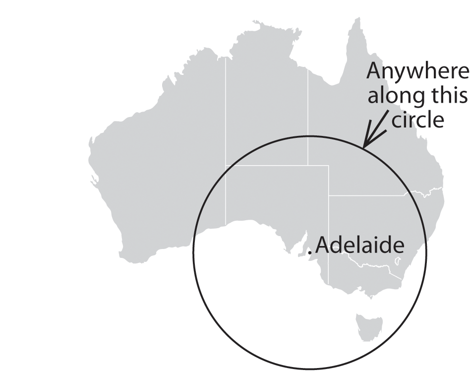
Imagine you are somewhere in Australia and you are TOTALLY lost - for whatever reason, you have absolutely no clue where you are. You find a friendly local and ask, “Where am I?” He says, “You are 1290 km from Adelaide.”

This is a nice, hard fact, but it is not particularly useful by itself. You could be anywhere on a circle around Adelaide that has a radius of 1290 km, you could be in Newcastle, Towoomba, Alice Springs or on the Nullabor.

australia_1.png

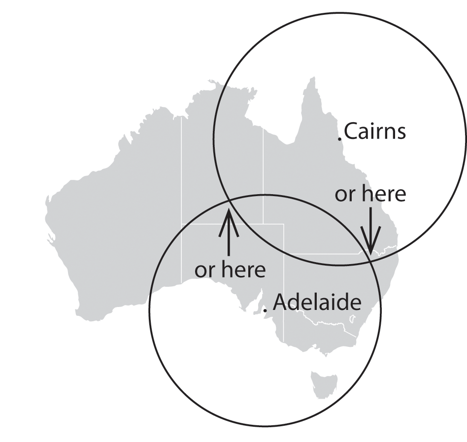
You ask somebody else where you are, and she says, “You are 1451 km from Cairns.” Now you’re getting somewhere. If you combine this information with the Adelaide information, you have two circles that intersect. You now know that you must be at one of these two intersection points.

australia_2.png

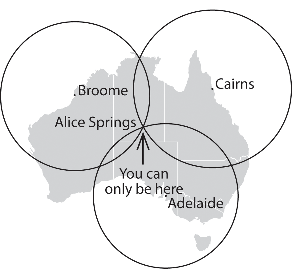
If a third person tells you that you are 1368 km from Broome, you can eliminate one of the possibilities, because the third circle will only intersect with one of these points. You now know exactly where you are - Alice Springs.

australia_3.png

The example uses only three locations - not four - because it is only working in two dimensions. GPS uses a fourth location to determine the elevation, and to improve accuracy.
 

Back
Top Bottom