Xeric
RETIRED THINK TANK

- Joined
- Mar 31, 2008
- Messages
- 8,297
- Reaction score
- 42
- Country

- Location
There are no remaining parts.
As with 'I' that you had highlighted - which I forgot to address - is entirely something else. The body text itself is divided in 2 parts. Part I is 'Introduction' and Part II is 'Agreement'. Due to scanning issue, the Part II got cropped in this document.
Just download UN document S/1430/Add.1 and go to Annexure 26. Alternatively, here is UN Treaty Series, Vol. 81.
Edit: Corrected document name and added link to 'UN Treaty Series'
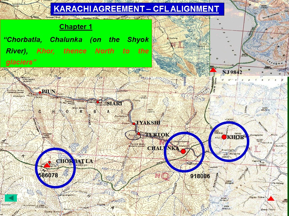
i know what does the UN docs S/1430/Add.1, Add.2 and Add.3 or the S/1100, S/2967, S/2448 etc Interim Reports say. The argument here is on the connotation of "thence north to the glaciers" part of the KA-1949. You like to understand this as the CFL is to be extended beyond NJ9842, where as we and the self-explanatory KH01949 says that NJ9842 is the terminal point. Here's what the text you all like to quote says:
.....Chalunka (on the Shyok River), Khor, thence north to the glaciers. This portion of the cease- fire line shall be demarcated in detail on the basis of the factual position as of 27 July 1949, by the local commanders assisted by United Nations military observers.
What you dont like to see is the fol part of the agreement:
.....Chalunka (on the Shyok River), Khor, thence north to the glaciers. This portion of the cease- fire line shall be demarcated in detail on the basis of the factual position as of 27 July 1949, by the local commanders assisted by United Nations military observers.
So what needed to be demarcated? The alignment of CFL has been amply covered in KA-1949 in Sub Para 'B' 2 (a) to (d). The KA-1949 further says in para 'C':
C. The cease-fire line described above shall be drawn on a one- inch map (where available) and then be verified mutually on the ground by local commanders on each side with the assistance of the United Nations military observers, so as to eliminate any no-man's land. In the event that the local commanders are unable to reach agreement, the matter shall be referred to the Commission's Military Adviser, whose decision shall be final. After this verification,
Troops of either side were already there on ground, the area where there were no troops on ground was the area beyond NJ-9842 which was inaccessible - for the same reason the area beyond NJ-9842 was left indemarcated in 1947. The generalized mention of 'thence north to the glaciers' after alignment till Khor, despite giving a detailed explanation of the alignment prior to that indeed acknowledges the fact that by 'glaciers' (being inaccessible and thus indemarcated) the agreement infact made a reference upto NJ-9842: the last point which was accessible to man at that time.
How can they after pinpointing approximately 118 locations/reference point (that's what i have been able to roughly count between para B 2 (a) to (d)) to explain the alignment of CFL gave no further clear reference points to the CFL's alignment beyond Khor and just made a casual reference i.e thence north to the glaciers and despite the fact that there were no ground troops on the glacier, just handed over the same to India? Wow!
i mean, you actually want us to believe that after painstakingly using 677 words (between para B 2 (a) and (d) - till the word Khor) to explain the CFL, those geniuses just said, "hey, we are tired of this shyt, let's just say 'thence north to the glaciers' and forget that:
- NJ9842 is the last place which can be reached.
- there has been no fighting for the claim of the area beyond NJ 9842.
- there are no troops beyond NJ 9842.
- though the question of Siachen's claim has even not been raised during the agreement.
Still, just hand the bloody thing to India?!"
Yeah, right!! i mean, you guys are more unbelievable then these friends of yours:
On a serious note, please tell, going by your understanding of 'thence north', where would this CFL, traveling North, without any mention of a terminal point, would end? Not at the North Pole, i hope?
As the area beyond NJ9842 (the glacier itself) was inaccessible, unmarked, unknown at that time, by 'thence north towards the glaciers' have no other connotation except that the CFL, moving up north, terminated at NJ9842 - the last point known, accessed and marked on map.
Last edited: