What's new

Fascinating Bengal

Lost Mughal Palace

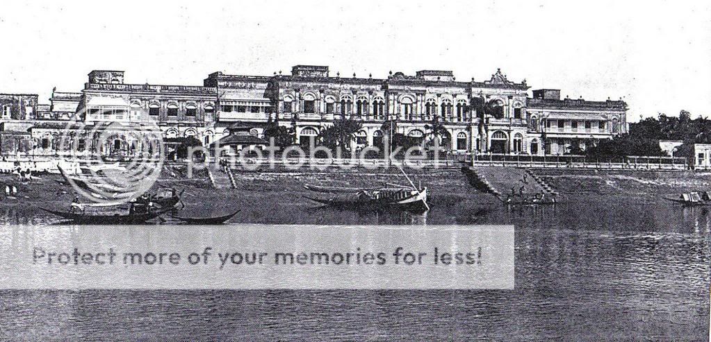
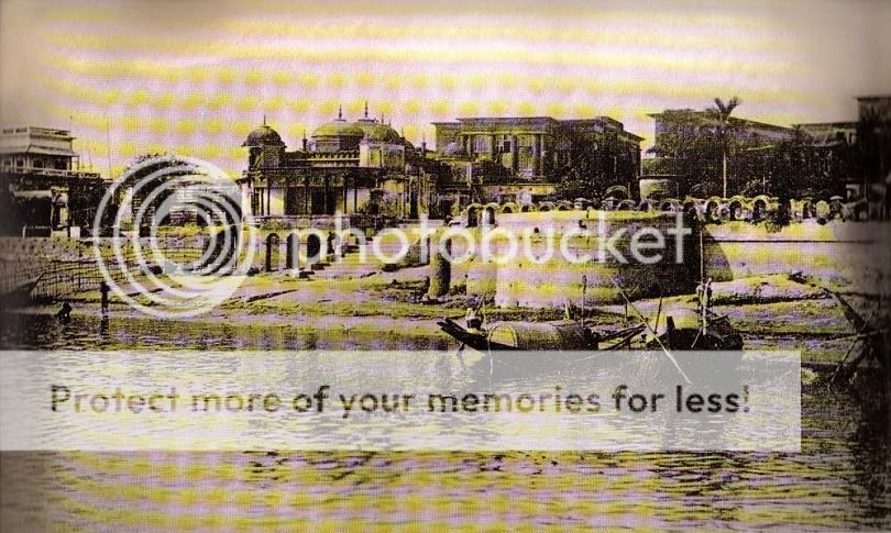
Take a look at this magazine illustration from 1874. The second picture is of Bara Katra, the third picture is of Shat Gombuj Masjid, and the fourth picture is of Lalbagh Fort. For me, however, the most interesting drawing is the first one, entitled "Ruins of the Nawab Baree." I am not certain, but I believe that this could be a picture of part of the palace of the Nawabs at Jinjiira, on the bank of the Buriganga opposite Dhaka. If so, this is the only picture of that complex I have ever seen, although D'Oyly is also supposed to sketched a picture of it (there is probably nothing left of it now; when my sources were written in the 1980s, there were just a few ruins amidst the slums). This palace was built by Nawab Ibrahim Khan II, who governed from 1689 to 1697. The palace was a grand complex surrounded by a moat and connected to Dhaka proper by a wooden bridge. In the 1980s, the remains of seven apartments with chau-chala roofs and a large hammam could still be made out. According to tradition, the wife and mother of the last independent Nawab of Bengal, Shiraj Ud Daulah, were imprisoned in this palace after he was toppled by his trecherous general, Mir Jafar, who effectively handed power over to the British in 1757. The two women were murdered by being drowned in the river.

graphic1874.jpg
 
Mosque of Kar Talab Khan

There are a handful of Mughal period mosques surviving in Dhaka today, thanks to continuous usage through the years. Several of them, including the ones of Lalbagh Fort, Khan Muhammad Mridha, Haji Khwaja Shabaz, and Shat Gombuj, survive largely unchanged thanks to the work of conservation advocates.

The largest, and in my opinion most beautiful of Mughal mosques in Dhaka, is that of Kar Talab Khan built about 1700, now commonly known as Begum Bazar Mosque. Kar Talab Khan aka Murshid Kuli Khan was appointed governor of Bengal in 1701 by emperor Alamgir (Aurangzeb). When the Mughal empire began to desintegrate shortly after Alamgir's death in 1707, Khan became de facto ruler of Bengal, Bihar, and Orissa, thus initiating the dynasty of independent "nawabs" which ruled until the advent of the British Raj. In 1717, he shifted the capital from Dhaka to Murshidabad (West Bengal), which is named after him.

This mosque has a five domed prayer hall, with three larger domes having two smaller domes between them. Also at the side of the prayer hall, is an elegant room in the form of a hut of rural Bengal - not uncommon in Mughal architecture.

Below left, is a distant view from a 19th century photo, before modern extensions. Below right,a portrait of Murshid Quli Khan.

019PHO000001019U00005000SVC2.jpg


mur.jpg
 
Lost Buildings of the Mughal Period

As I have mentioned before, there are many buildings from the Mughal period, which have not survived. The ruins of a few of them can be seen in D'Oyly's sketches, from around 1814:

This picture is entitled, Interior of the City of Dacca. I have no idea what kind of buildings they are:

019XZZ000000628U00018000SVC2.jpg


This picture is of Chowk Bazar. Chowk Bazar was main market place / central square of Dhaka. Interestingly, D'Oyly labels the building as the "Husaini Dalan." Of course, it looks nothing like the Husaini Dalan of today. There are two possiblities - either that D'Oyly mistakenly labeled another mosque as being the Husaini Dalan, or that there was a different Husaini Dalan back then. Since D'Oyly is usually pretty accurate, I would probably say the latter:

doyly1827-2.jpg


This is the mosque of Syuff Khan. To the best of my knowledge, it does not survive today. It looks to be an impressive structure:

mosqueofsyuffkhan.jpg


This was a mosque in Magh Bazar. I think that is Mirzazeehan with his back turned to us, but I can't be sure since I can't see his face :

maghbazar.jpg


Finally, D'Oyly does not specify where this mosque is, except that it is in a suburb of Dhaka:

suburb.jpg
 
Damn we lost so much.

You are right... the main reason is Battle of Palashy of 1757 and Mir Zafar.... British used treasure of bengal to maintain their force here, expanded there business and colonized other part of indo sub continent...

Battle of Palashy is one of the most decisive war in the history of the world... If british would have lost the war... they would fail to colonize indo sub continent... n the whole world history would be differfent,,, U can say this is the worst defeat for the muslim even in some cases it causes more damage than the destruction of Baghdad by the mongols...

Just for your info british looted 2.5 million pound worth of amount from the treasure of Nawab Sirajuddawla in Murshidabad... which is almost equal to the british GDP at that time... British GDP was worth 16 million pound in 1800.
 
Chawk Bazar and Bibi Mariam

From Mughal and through Colonial times, Chawk Bazar was the main marketplace / square of Dhaka. In my last post, there is a picture of Chawk Bazar from the early 19th century. The photo below is from the 1880s. Note the Chawk Bazar mosque, a Mughal structure from 1676 (by this time modified with the addition of a classical European portico). Also note the cannon, called Bibi Mariam, in the center of the square. This cannon was brought to Dhaka by Mughal Subedar Mir Jumla as a memento of a military campaign in Assam (actually, he brought back two massive cannon, but the other one, called Kale Jamjam, sank in the Buriganga):

chowk2.jpg
 
Shat Masjid and Beri Bund

Of all the Mughal mosques in Dhaka, the one that most appeared in old pics and photos was the Shat Gambuj Masjid (Mosque of Seven Domes). In fact, if you look at old books or magazines with pictures of Dhaka, there will usually be a pic of this mosque. There are two reasons for this. For one, in addition to the standard Mughal three domed prayer hall, the corner turrets also had domes on top, which gave the mosque a unique appearance. More importantly perhaps, was its dramatic and picturesque location on the edge of the Buriganga flood plain. People visiting today, however, see a very different vista. After the devastating floods of 1988/89, a dam (the Beri Bund) was constructed along the western edge of Dhaka to protect it from flooding. The area behind the mosque was drained and filled up, and now is full of buildings. So, the scenic aspect of this mosque no longer exists. However, happily, the building itself, under protection of the Directorate of Archaeology, survives unchanged and in a good state of preservation.

The first picture is a sketch of the mosque by D'Oyly (early 1800s). The second shows the plan of the mosque, with its hollow domed turrets. The third shows the mosque as it appeared before the construction of the Beri Bund. The final picture is from a few years ago, more or less as it appears today. More recently, the Mughal-style plasterwork has been covered up by an ugly whitewash. Tmac has posted some pictures of this whitewash in the Bangladesh Tourism thread. Good thing is that this unfortunate change can easily be undone.

oldsatmasjid.jpg


sat2.jpg


sat3.jpg
 
A nice informational thread indeed and thanks to sami6108, i learned a few things about history of that part of the world.. Keep going..:tup:
 
Mughal Katras Revisited

All right! Time to continue with our 19th century river cruise! In the first page of this thread, I posted some info and pics about the history and plight of the two surviving Mughal katras (caravanserais) in Dhaka. Although the current pitiful condition of these structures may not convince some people that they are worth saving, I hope the following pictures give a sense of how fine these structures looked along the Dhaka riverfront.

First, the Chhotta Katra (Small Caravanserai), in a picture from around 1880:

chhotokatra.jpg


I don't have a picture of comparable quality of the Bara Katra (Big Caravanserai). However, this one from around 1840 should give an idea of its grandeur:

katra.jpg
 
Riverfront Mosques

Continuing with our cruise, circa 1880. We see several mosques built along the riverfront. This is the mosque of Mirza Golam Pir. Mirza Golam Pir had considerable land holdings in Tippera (Tripura) and Bakerganj districts. His grandfather, Mir Abu Sayeed, came to Dhaka from Turan in the third quarter of the 18th century. He died in 1860.

rm.jpg


And this is the mosque of Darogah Amiruddin. Amiruddin was probably a Darogah in the police department of the East India Company in the early 19th century. Here at Babu Bazar, there used to be a market for firewood along the riverbank, which you can see in the foreground of the picture:

mosque2.jpg
 
The Armenians

We continue with our river cruise, circa 1880. There are many mansions lining the waterfront. After all, if you are a big shot, this is the place to build your house. This one, for example, was built by Manuk, a zamindar of Armenian descent:

manuk.jpg


But what is an Armenian doing in Dhaka? Armenians, like other foreign ethnic groups, came to the subcontinent in search of new opportunities. The earliest Armenian grave in Dhaka that I am aware of, is dated 1741, so it is reasonable to assume that the first Armenians arrived some time prior to that. At that time Dhaka was still a large and prosperous city in the post-Mughal period. Initially these people found success as contractors in the salt trade. As Dhaka declined in the early years of British rule, the Armenians stayed on, now working on behalf of the East India Company. The Armenian Church, founded in 1781, was a focal point of this community, and still today remains perhaps the most significant of Dhaka's historic churches. Eventually Armenians sought opportunities in other commodities, such as jute and leather, and were quite successful in this regard. By 1900 there were around half a dozen families of Armenian zamindars in Dhaka, such as that of Manuk. Over time this community has gradually whithered away. As of a few years ago, there was just one Armenian left in Dhaka, who used to look after the church. I don't know if he is still alive or not (he would be 77 this year). The church, to the best of my knowlege, hosts multi-denominational (as opposed to Armenian) services today.

od8.jpg
 
New Nawabs

Getting back to our river cruise...here is the version of the Ahsan Manzil we are more familiar with, seen from Buriganga beyond the Buckland Bund. As I mentioned in my previous post, the building was remodeled after being heavily damaged by a Tornado in 1888. This was the home of the Khwaja family, the most prominent Muslim family of those times:

ahsan.jpg

alimullah.jpg

abdulghani.jpg

ahsanullah.jpg

salimullah-1.jpg

habibullah.jpg
 
Ruplal House

If I could save just one historic mansion in Dhaka, it would be Ahsan Manzil. Happily, this has already come to pass. If I could save just two, the other would be Ruplal House. This grand manor with riverfront facade of around 300 feet was the largest private home in Dhaka. The oldest part of this house was built by an Armenian zamindar, Aratun, in the 1700s. In 1840, two wealthy brothers, Ruplal Das and Raghunath Das, bought this older building and had it extensively altered and expanded by the famous Martin Company of Calcutta. The house's finest hour came in 1888, when a ball was staged in its main hall on occasion of the visit of Lord Dufferin, then Viceroy of India.

The pic below is a special one, in my opinion - it is the only complete riverfront picture of the house that I have ever seen (the second pic is a detail of the first). I found it in a book of pictures on India published in 1911, in the basement of a university library here in the USA. In my next post, I will comment on the current situation of this important Dhaka landmark.

ruplalhouse1.jpg


ruplalhouse2.jpg


Ruplal House is shaped like a [ , with the long axis parallel to the river and two blocks at each end projecting towards the city side. The western block is the grander of the two and was owned by Ruplal, while the eastern block was owned by Raghunath. The two are connected by a central block running parallel to the river. Today, the whole building is encircled by sheds and other structures, making it difficult to take photographs. Ruplal's block is occupied by a variety of traders and also serves as a grand shanty (like Ahsan Manzil not so long ago). Raghunath's block, to the best of my knowledge, is under private ownership. There are over fifty rooms, including the grand hall where the Dufferin ball was staged.

The pictures below, showing Ruplal's section (western end of the house), were only possible from a high vantage point:

ruplal1-3.jpg


ruplal2-1.jpg


The picture below shows the connection between Ruplal's section on the right, with the central block on the left. The central section is completely obscured by the aforementioned sheds and other structures. This is the only unobstructed view possible from ground level today.

ruplal1-2.jpg


The pictures below show a few other aspects and details. The last pic is the entrance to Ruplal's section.


ruplal4-1.jpg


ruplal6-1.jpg


ruplal3-1.jpg
 
Mill Barrack

If you really were cruising along the Buriganga in 1880, the order in which you would see the buildings we have described previously, west to east, are Lalbagh Fort (possibly hidden behind buildings), Bara Katra, Chhotta Katra, Mosque of Mirza Golam Pir, Mosque of Amiruddin Darogah, house of Manuk, Ahsan Manzil, Northbrooke Hall, and Ruplal House - in that sequence. Going past Ruplal House, the last major urban sight would be the Mill Barrack, which was built as a sugar mill in the first half of the 19th century. During the uprising of 1857, the British army took control of the building and converted it into a barrack. Hence, the name Mill Barrack. I am not sure whether this building is still around, or not.

mill.jpg
 
Back
Top Bottom