What's new

OSINT India/Israel/UK 'targets' China, Pakistan, Iran & Turkey via Satellite Imagery illegal details

when you launch multiple satellite at a time,similarly multiple warheads can be launched at a time in path of same orbital which satellites are following and they will ultimately collide with satellites resulting in their destruction
You be wasting them since spy satellites don't group in together and are separated by thousands of miles. They won't have the fuel to reach them all.
 
when you launch multiple satellite at a time,similarly multiple warheads can be launched at a time in path of same orbital which satellites are following and they will ultimately collide with satellites resulting in their destruction
Theres a problem with that. You have to figure out how to deal with satellites launched from half way around the world, as well as contend with their maneuvering thrusters that can easily change directions. If you want to destroy the satellites, you should do it while its still in the capsule and being launch. Not after. And another problem is the DARPA has plans where they can launch multiple satellites in days and in different locations. This was because of possible threat by China and Russia that could target their spy satellites.
 
warheads can also get such thrusters to intercept maneuvering satellite just like sam warhead takes down fighter jet once fired by using radar and navigation within warhead and downing fighter jet is much difficult as compared to satellites which are less maneuverable,china and russia can also launch antisatellite weapons in short time as russian s500 mobile airdefense system can shoot down satellites so such capability is not limited to u.s only
Theres a problem with that. You have to figure out how to deal with satellites launched from half way around the world, as well as contend with their maneuvering thrusters that can easily change directions. If you want to destroy the satellites, you should do it while its still in the capsule and being launch. Not after. And another problem is the DARPA has plans where they can launch multiple satellites in days and in different locations. This was because of possible threat by China and Russia that could target their spy satellites.
 
He is using commercial satellite imagery for pointless analysis,if IMINT was everything in itself, US won't need to send in Human Assets to the ground and risk their lives. If IMINT could save lives, eagle claw would have been successful.
If IMINT was everything than Indians would not have to face the huge embarrassment on Feb26 in Balakot
Realtime Imagery is something that gives you insight in planning operations which Indians & Pakistan both have access to. Pakistan also have partnership with access to Hi-Res Sat imagery in real time. No need to pay heed to such OSINT handles, they are just propagandists

I wont call it pointless analysis so early @Foxtrot Alpha. Through commercial or military satellite imagery it is certainly an Excellent fact-checking - with locations, details and satellite imagery. Let such #OSINT has become a standard of military/defence reporting. Time to banish - “according to sources / confidential data, et. al.”

This does gives an edge to what happened before an event such as Balakot, or Pakistani Mirages attack on 6 Indian targets, OSINT analysis. Roam of lying and faking up story is diminished that is whether target hit the area, damage assessment etc. Most Channels can to a certain degree rely on it to "Forward their country Narrative".

But biggest question is, like Indians do, bring Graphic Designers, and fake up google maps locations and positions when satellite is not even on top of the location or position anymore.

This is hardly confidential information. You don't need a satellite to capture fighter jets parked under the open sky.

I have not mentioned anywhere as confidential, as its Open Source Intelligence, but illegally spying on each of the country assets, locations, previous movement and new movement are some of intelligence related important information before a attack is planned.

All these planes, military assets, trucks, radars, subs are being tracked.
 
I wont call it pointless analysis so early @Foxtrot Alpha. Through commercial or military satellite imagery it is certainly an Excellent fact-checking - with locations, details and satellite imagery. Let such #OSINT has become a standard of military/defence reporting. Time to banish - “according to sources / confidential data, et. al.”
....

Here I agree with you, some of these are in no way pointless, they are some great means of analysis which help to present facts and these facts are nothing but secret or confidential but simply open source!


I have not mentioned anywhere as confidential, as its Open Source Intelligence, but illegally spying on each of the country assets, locations, previous movement and new movement are some of intelligence related important information before a attack is planned.

All these planes, military assets, trucks, radars, subs are being tracked.

So what? As you noted yourself, all these analysis and are made by some very interesting guys and based on pure commercially available open source material. So if you want to avoid such work to be done, you should contact those, who provide such imagery and not those who put the pieces together.

Just like me for example ... am i a spy since I'm collecting open source images of Chinese military aircraft, their bases and so on and put together my own conclusions and Orbat lists?


So how could they be illegal when they are available via open source?
 
Last edited:
Here I agree with you, some of these are in no way pointless, they are some great means of analysis which help to present facts and these facts are nothing but secret or confidential but simply open source!

So what? As you noted yourself, all these analysis and are made by some very interesting guys and based on pure commercially available open source material. So if you want to avoid such work to be done, you should contact those, who provide such imagery and not those who put the pieces together.

Just like me for example ... am i a spy since I'm collecting open source images of Chinese military aircraft, their bases and so on and put together my own conclusions and Orbat lists?

So how could they be illegal when they are available via open source?

I am saying illegal on the basis that, it is without the permission of the country in target, though its Open Source, any location, military location, building which a country wants to keep secret from lets say terrorist, Alqaeda, this open source from the fellow country like Israel, UK, Canada actually becomes a problem and gives locations GPS coordinates. It is clearly helping the terrorists.

What if Pakistan, Turkey, Iran, Russia or China has a treaty signed with Israel, UK Canada or whoever does this, it will be helpful.

Yes it is nowadays used to present facts, but a mechanism has to be defined to know if its not photo shopped or faked.

That's an important point indeed to be negotiated, but as log as such satellites are allowed to take pictures on the open market, I think there is no way - and even no right - to blame those analysts of using them.
 
Pakistan must have an in-house OSINT Program for using military or civil orbits for Open Source use. I know it has its own satellites in space, so a NSA like ORG which is used to distribute vital information to news outlets, channels, social media can put facts correct, build our narrative. Pakistan military, air force, ISI, MI, FIA, Navy, Civil administration, Army etc must work together to built an "organization" of this sort, where reliable information is passed to public on any event that occurs, we do-not have to look for other Open Source Intelligence Tools and outside sources, depending on other countries.

Pakistan needs our very own NSA. I have been saying this for years now.

Yes, Pakistan, China, Turkey, Arabs even Iran need to all ally to have its own NSA or some new organization in-collaboration to have such commercial satellite activity against these countries if not already have an a collaborative ORG in existence.

That's an important point indeed to be negotiated, but as long as such satellites are allowed to take pictures on the open market, I think there is no way - and even no right - to blame those analysts of using them.

Are they no agreed protocols or measures to take pictures openly. Otherwise it will have to be protested in international court and UN, about the illegality of taking pictures and putting through Open Source on Social media, internet and TV.
 
Are they no agreed protocols or measures to take pictures openly. Otherwise it will have to be protested in international court and UN, about the illegality of taking pictures and putting through Open Source on Social media, internet and TV.


I'm sure if it would be forbidden, these image won't be available on the open market.
 
I'm sure if it would be forbidden, these image won't be available on the open market.

Yes True - Look at this you can easily buy images off market through Intelligence consultancy company for such as regional conflicts, foreign military combat capabilities, general military intelligence assessments and intelligence collaboration.

How an Intelligence company uses SkyWatch Earth Cache
case study
ShadowBreak is an Intelligence consultancy company that focuses on layering data from a variety of sources to provide multi-Intelligence analysis for their military, governmental, and corporate clients.

Both their solutions, ReconLink and TacSight, deliver critical insight for decision makers on vital security issues such as regional conflicts, foreign military combat capabilities, general military intelligence assessments and intelligence collaboration.

How ShadowBreak uses satellite data
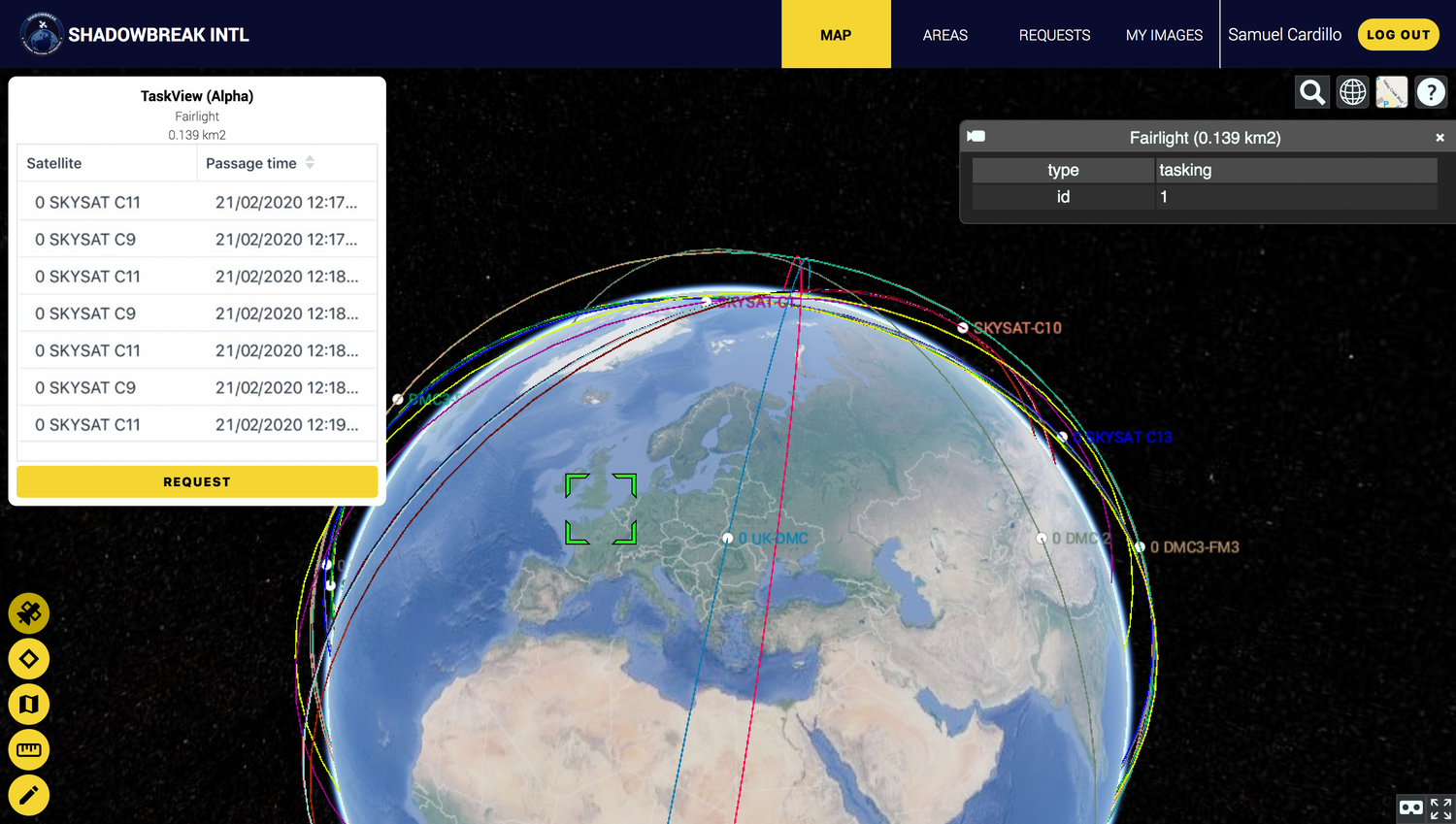
With ReconLink, ShadowBreak customers can access recent imagery and automatically request new images over a certain area. In order to enable customers to request tasking data, the development team at ShadowBreak built a simple integration between ReconLink and the EarthCache API. Thanks to EarthCache, ShadowBreak was able to build this new feature for their customers in less than a few weeks.

How+to+request+satellite+image


A smooth integration was key to the success of the project
For the team at ShadowBreak the interaction needed to be as smooth as possible for their customers. Within their platform, users are able to check their preferred location for archive data, look at the path of satellites to plan for future requests and, with one click of the button, place a tasking order for future satellite imagery to be collected and delivered. That’s when SkyWatch came into play. Thanks to EarthCache, a platform that allows users to automatically request data from satellite imagery providers, ShadowBreak’s customers can place tasking orders with minimal friction.

Aggregation is a nice perk
“For us, it doesn't really matter where we get our data”, said Samuel Cardillo, CEO of ShadowBreak. However, Cardillo noted it can be time-consuming to sign new deals with the current satellite imagery providers and this diverts resources away from Development and Operations. By integrating EarthCache into their ReconLink platform, ShadowBreak was able to add new datasets to their current offering with just a few lines of code.

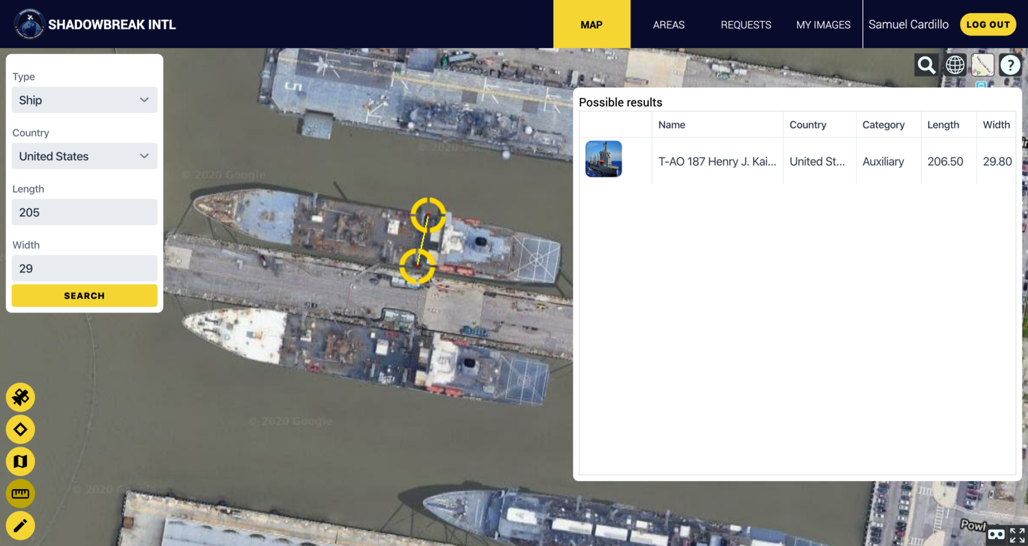
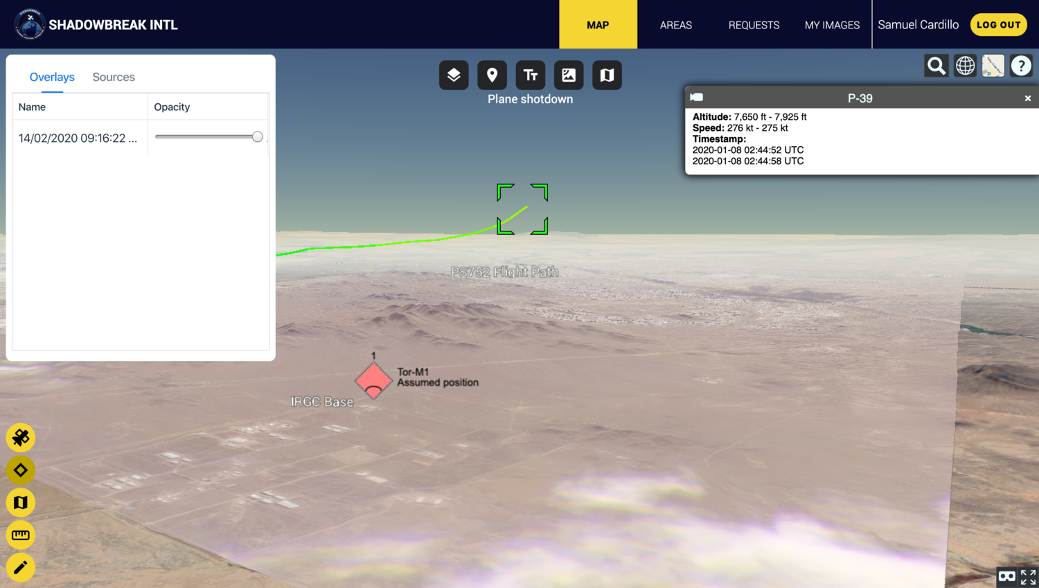
This allowed Cardillo and his team to focus on building newer features, such as asset detection capabilities, measurement tools, layering information on military assets and on building a collaborative way for their TacSight users to share geospatial information across teams.

TacSight+ShadowBreak+satellite+data+boat+monitoring


Favourite feature: cropped results
“Everything is amazingly cropped to fit the AOI we set” commented Cardillo. “I was amazed the first time I tried it. I am still amazed whenever I see an image perfectly cropped to my polygon.” Being able to deliver images cropped to the pixel help reduce the size of the file EarthCache users need to download, which makes it easier and less costly for developers to ingest and process. Being able to save even a couple of seconds between order and delivery is key to delivering a great customer experience, both for ShadowBreak and for SkyWatch.

TacSight+Shadowbreak+tracking+airplanes+and+events


https://www.skywatch.com/blog/how-i...ource=t.co&utm_medium=social&utm_campaign=SEM
 
These are the good ones. Experts in Geosciences and Remote sensing. They have been doing it for years and are credible and they serve as public info such as media and us whoever follows them. The government agencies have better satellites they don't need Planet labs satellites which OSINT mostly relies on. (We launched their sats more than 100 of them).
 
Turkey is developing powerful lasers to blind/dazzle Observation satellites in low earth orbit.
 
What are they spotting? A military base at Gwadar? A supposedly nuclear enrichment site at some new location?

Much of it is based on pure speculation. Besides, even if these so-called intelligence reports are true, what are they worth? Countries which cooperate with each other don't hide their activities. If China and Pak were building a naval base at Gwadar we would do it as openly and transparently as possible. We don't require permission from irrelevant countries on the other side of the Atlantic.

These Twitter handles look more like psyops.
This is hardly confidential information. You don't need a satellite to capture fighter jets parked under the open sky.
upload_2020-6-5_8-38-54.gif
 

Latest posts

Back
Top Bottom