What's new

How difficult would it be for China to invade Taiwan?

But they will hit your hundreds of bombers easily, and your kashgar airbase can easily hit by 2500 km range Tomahawk cruise missiles from SCS or Taiwani straight

Kashgar is 4,000+ km from the coast. Tomahawk don't have the range to reach Kashgar from South China Sea.

And USN have no defense against your Bombers lol, THey will lit by Agis PESA hundred miles inland, lolo just lol

Can't shoot down hypersonic anti ship missiles launched from H-6N bombers.
 
Last edited:
kid kid calm down Agis destroyer also has SM-5/6 to shoot down your mighty DF17/25 and 26 and for USAF bases in far east are protected by THAAD
:rofl::rofl::rofl:

How then your touted defense systems all failed in Saudi Arabia?


And that against only puny sub sonic slow poke drones and missiles


Murica touted ability with their super duper missiles of Thaad and Patriot and Aegis to defend KSA that Murica so clearly and explicitly demonstrated to te entire world


:omghaha: :omghaha::omghaha:


1602377212761.png


1602377146518.png


4a5fa3802642.jpg


https://www.reuters.com/world/middl...es-destroy-houthi-drones-state-tv-2022-03-25/


So you think you be doing much much better against supersonics and hypersonics missiles by the hundreds and thousands?
:omghaha::omghaha:
 
https://eurasiantimes.com/china-plans-to-turn-its-satellites-into-spy-fighter-jets/

Shadowing F-22 Raptor – China Plans To Turn Its Low-Cost Satellites Into Spy Platforms That Can Even Track Fighter Jets​

By
Ashish Dangwal
-
April 8, 2022

https://www.facebook.com/sharer.php?u=https://eurasiantimes.com/china-plans-to-turn-its-satellites-into-spy-fighter-jets/
https://twitter.com/intent/tweet?text=Shadowing+F-22+Raptor+–+China+Plans+To+Turn+Its+Low-Cost+Satellites+Into+Spy+Platforms+That+Can+Even+Track+Fighter+Jets&url=https://eurasiantimes.com/china-plans-to-turn-its-satellites-into-spy-fighter-jets/&via=THEEURASIATIMES
https://api.whatsapp.com/send?text=Shadowing+F-22+Raptor+–+China+Plans+To+Turn+Its+Low-Cost+Satellites+Into+Spy+Platforms+That+Can+Even+Track+Fighter+Jets https://eurasiantimes.com/china-plans-to-turn-its-satellites-into-spy-fighter-jets/
https://reddit.com/submit?url=https://eurasiantimes.com/china-plans-to-turn-its-satellites-into-spy-fighter-jets/&title=Shadowing+F-22+Raptor+–+China+Plans+To+Turn+Its+Low-Cost+Satellites+Into+Spy+Platforms+That+Can+Even+Track+Fighter+Jets

China is reportedly developing an advanced artificial intelligence system that could turn low-cost commercial satellites already orbiting the Earth into potent spy platforms. Reports suggest that it may have a success rate roughly seven times greater than existing technology.

Ukraine’s ‘Digital’ Soldiers Use British ‘Star’ Missile To Shoot-Down Russian Attack Chopper; Marks First Kill For UK MANPADs

This system is being developed by Chinese military researchers, who say that it is capable of tracking moving objects as small as a car with extraordinary precision, reported Chinese media.
The challenge of distinguishing a target via satellite footage was illustrated in 2020 when a Chinese space company released a video clip taken by Jilin-1, a small satellite. The satellite was presumably pursuing a cruising fighter jet from an altitude of almost 500km (310 miles).

Changguang Satellite, the manufacturer of the Jilin-1 Satellite, released that footage, which was extensively shared on Chinese social media platforms. A fighter plane can be seen flying over the city in the video. The company also put a caption beneath the video, allowing internet users to identify the fighter’s type.
getInterUrl
China’s satellite apparently captured high-speed flying fighter
Many internet users speculated that the fighter jet was most likely the US-made F-22 stealth fighter. Its horizontal tail and wing were similar to those of the F-22 fighter, leading to the assumption. This entire predicament was ostensibly the catalyst for the development of new technology. The plane in the video was approximately 20 meters (65 feet) in length.


The commercial satellite’s camera, which has a resolution of around 1-meter, would only produce a few pixels of the small target. It is even more difficult to recognize an object when there are fewer details in the image.
Since each frame of the satellite footage encompassed more than 10 square kilometers, a small target like a car could fade into the background or be confused with other cars. This will probably make tracking its path from orbit virtually impossible.
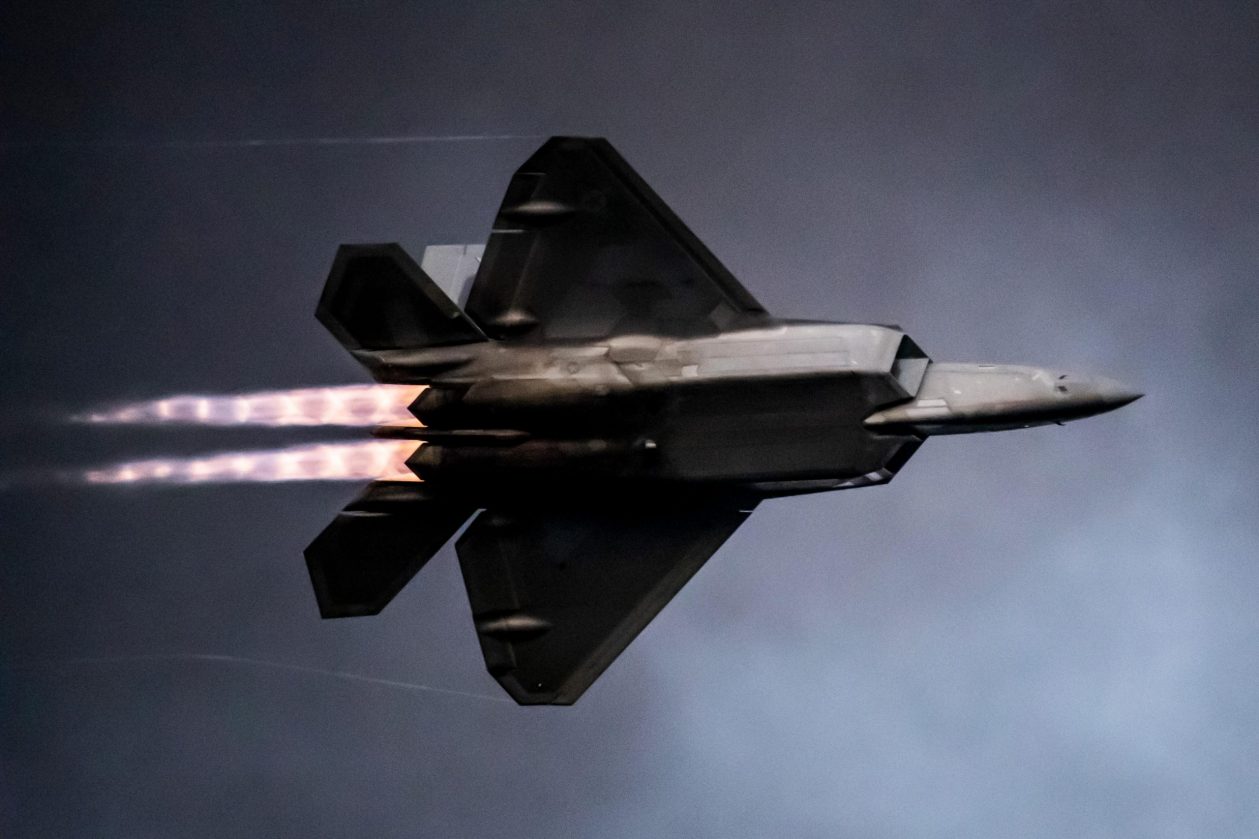
f-22
File Image: F-22 Raptor
The Chinese team claimed that its new AI technology had attained 95% precision in finding a small object in the videos recorded by Jilin-1, with a success rate approximately seven times greater than existing technology.
Lin Cunbao, a researcher from the People’s Liberation Army’s Space Engineering University in Beijing, and his colleagues made these claims.

The Issue With Existing Technology

Jilin-1 was China’s first commercial Earth observation satellite. It was launched on 7 October 2015. The Jilin-1 weighed less than 100kg, compared to standard spy satellites that carry a large telescope (220 pounds). It orbits the Earth at a low altitude, which allows it to achieve higher resolution. However, it can only stay over an area for a short time.
After the first Jilin satellite was launched, approximately 40 more joined the family to establish a global monitoring network capable of detecting a wide range of signals, from visible light to heat traces, at practically any time, anyplace.
In the near future, the constellation is projected to be expanded to 138 satellites, allowing for high-resolution imagery and considerable commercial service. Despite their strengths, Lin claims that most commercial satellites would be unable to pursue a small moving target due to technical limitations.
Artistic rendering of a China's satellite - CGTN
Chinese Remote sensing satellites – Chang Guang Satellite Technology via CGTN
A satellite video stream, which typically records roughly 15 frames per second, has a far lower resolution than a motionless picture taken by the same camera. Due to the obvious satellite’s high speed, practically everything in the video is moving, such as buildings and their shadows, leaving standard technologies built to identify motion against a fixed landscape less efficient.
The flexibility of vehicles on the ground to stop unexpectedly, make a quick turn, or move under a bridge or through a tunnel adds more complexity to the process. According to the researchers, even a well-trained AI program could lose track of its subject if half or all of an object vanishes.

How Will The New Technology Work?

Upon losing the target, the AI used to conclude it had got it wrong and input the negative information into the learning process, which would drastically lower its overall effectiveness.
Lin’s team claimed to have created a more trustworthy AI based on a traditional machine learning algorithm that had only obtained about 14% success in analyzing satellite video prior to the team’s improvements.
Additionally, When the target was temporarily hidden in the new iteration, the machine did not second-guess itself. Rather, based on previous experience, it would predict the target’s possible position and resume tracking along the path it anticipated the target would travel. The Chinese researchers claimed that the new technology could reclaim the target as soon as it resurfaced as a result of this system modification.
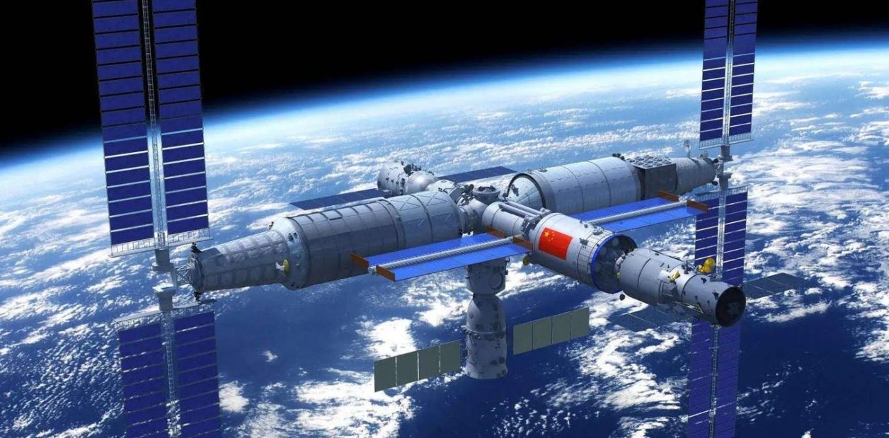
space-china
File Image: Chinese Space Station
Currently, visual data from the satellite must be relayed to a ground station or communication relay satellite nearby and analyzed by a powerful computer, resulting in a considerable time delay if the target is on the other side of the planet.
According to academics working in these initiatives, some new Chinese Earth observation satellites deployed in recent years contain processors that may be loaded with the newest AI algorithm to autonomously detect and track moving targets in real-time without any ground support.
China has made significant progress in space in recent years and is already working on other initiatives to broadcast high-definition video from orbit.
As previously reported by EurAsian Times, China will soon launch the Luojia-3 01 satellite which will test a novel technology that might provide smartphone users reasonably close access to high-definition cameras in space.
.


It will be even more easier to spot and track the movements of USA carriers and other naval assets as they move so much slower than F-22 Raptors.

Any naval assets of enemies of China can be so easily tracked and targetted for the DF-21s DF-26 and supersonic and hypersonic AShCMs to burn into and keep the sailors eternally young. Be those assets be on surface of water, and very likely, under the surface as well.

And China rest assured that USA protection cannot defend against a handful of subsonic drones and missiles in Saudi Arabia cannot defend against Chinese supersonic and hypersonic missiles.


🇨🇳 WANG SUI WANG WANG SUI 萬歲 萬 萬歲 🇨🇳
 
Kashgar is 4,000+ km from the coast. Tomahawk don't have the range to reach Kashgar from South China Sea.


Can't shoot down hypersonic anti ship missiles launched from H-6N bombers.
you think in all out war USAF bomber sitting idle, they will flying in central Asian states and launch their cruise missiles toward Kashgar airbase.

First of all you have very little hypersonic anti ship missiles, if you launch it toward USN ships in SCS or Tawani strait, USA will never sitting idle they will launch their ICBM toward China
 
:rofl::rofl::rofl:

How then your touted defense systems all failed in Saudi Arabia?


And that against only puny sub sonic slow poke drones and missiles


Murica touted ability with their super duper missiles of Thaad and Patriot and Aegis to defend KSA that Murica so clearly and explicitly demonstrated to te entire world


:omghaha: :omghaha::omghaha:


1602377212761.png


1602377146518.png


4a5fa3802642.jpg


https://www.reuters.com/world/middl...es-destroy-houthi-drones-state-tv-2022-03-25/


So you think you be doing much much better against supersonics and hypersonics missiles by the hundreds and thousands?
:omghaha::omghaha:
That was old Patriot PAC-2 with no capability to intercept drones and Missiles.

And you ever heard the term LAYERED DEFENSE SYSTEMS?
 
you think in all out war USAF bomber sitting idle, they will flying in central Asian states and launch their cruise missiles toward Kashgar airbase.

First of all you have very little hypersonic anti ship missiles, if you launch it toward USN ships in SCS or Tawani strait, USA will never sitting idle they will launch their ICBM toward China

No central Asian state would allow US air force to use its air space.
 
It isn't as easy as you think especially since Taiwan is heavily fortified and they got a lot of anti-ship weaponry.

China is right now lacking especially on anti-naval mine warfare ships... 055 destroyers are impressive but minesweepers would be more important if they want clear up way for transport ships. Currently PLAN has only 36-40 modern minesweepers.
You forget China has more than a thousand helo and 50-60 Y-9 transport plane plus not to mention Y-20 heavy transport. They dont need ships to transport most equipment.


Yeah, it would be really easy. That's what all countries say when they go to war... and then PLAN ships beging sinking and it's not an as easy figt anymore.


I doubt we'll see any invasion attempt after Russias blunders in Ukraine.
Ukraine is a good example why China shall retake Taiwan even more easier. Becos US will never involved as they will never died for non Americans.

Asking China to give on Taiwan is like telling Pakistan to give up on Kashmir. It's even more provocative when the foreign powers responsible for creating this situation are making diktats to the Chinese about it.
Ignore those clowns , they are sourgrape about rising China and the fact, useless Taiwan military is more and more incapable of defending themselves. So they need to come here and make their presence felt with delusion post.
 
Last edited:
Exactly.

The island of Taiwan is strategically important to China.

Taking it would not only remove any threat from it but also allow China naval bases in deep water to base its nuclear submarines in.
The more and more advance ballisitic missile from SSBN and mobile ICBM almost negates those points.

PLAN SSBN mostly patrol around South China sea only.

Right...China will try every decade? If China failed the first invasion, you can mock the Taiwanese for needing US help all you want, but that failure will push Taiwan further towards formal independence. We will learn what worked and will reinforce those tactics and technologies. China cannot afford a second failure.
If China succeed in taking back Taiwan? What will US do? Sanction all Chinese business, block all made in China product from USA, delist all Chinese stock from New York Stock Market or block China from SWIFT system? LOL..

Question to Chinese members
If one day Taiwan decides on one country two systems rule like HK under CCP

Would it be a acceptable to china?
China PRC already suggest that system to Taiwan and even allow Taiwan to keep certain amount of independent military forces for merge with PRC.
 
China should apply the American formula instead of the Russian formula.

The way to conquer democracies is to buy out opposition politicians and media.
China has the money.
Go to it.
China is not so low life like American.

are you indicating that weapons can be transported in trucks and aifcrafts but not ships? or you believe that China can create sea denial around Taiwan
Why not?
 
https://eurasiantimes.com/china-plans-to-turn-its-satellites-into-spy-fighter-jets/

Shadowing F-22 Raptor – China Plans To Turn Its Low-Cost Satellites Into Spy Platforms That Can Even Track Fighter Jets​

By
Ashish Dangwal
-
April 8, 2022

https://www.facebook.com/sharer.php?u=https://eurasiantimes.com/china-plans-to-turn-its-satellites-into-spy-fighter-jets/
https://twitter.com/intent/tweet?text=Shadowing+F-22+Raptor+–+China+Plans+To+Turn+Its+Low-Cost+Satellites+Into+Spy+Platforms+That+Can+Even+Track+Fighter+Jets&url=https://eurasiantimes.com/china-plans-to-turn-its-satellites-into-spy-fighter-jets/&via=THEEURASIATIMES
https://api.whatsapp.com/send?text=Shadowing+F-22+Raptor+–+China+Plans+To+Turn+Its+Low-Cost+Satellites+Into+Spy+Platforms+That+Can+Even+Track+Fighter+Jets https://eurasiantimes.com/china-plans-to-turn-its-satellites-into-spy-fighter-jets/
https://reddit.com/submit?url=https://eurasiantimes.com/china-plans-to-turn-its-satellites-into-spy-fighter-jets/&title=Shadowing+F-22+Raptor+–+China+Plans+To+Turn+Its+Low-Cost+Satellites+Into+Spy+Platforms+That+Can+Even+Track+Fighter+Jets

China is reportedly developing an advanced artificial intelligence system that could turn low-cost commercial satellites already orbiting the Earth into potent spy platforms. Reports suggest that it may have a success rate roughly seven times greater than existing technology.

This system is being developed by Chinese military researchers, who say that it is capable of tracking moving objects as small as a car with extraordinary precision, reported Chinese media.
The challenge of distinguishing a target via satellite footage was illustrated in 2020 when a Chinese space company released a video clip taken by Jilin-1, a small satellite. The satellite was presumably pursuing a cruising fighter jet from an altitude of almost 500km (310 miles).

Changguang Satellite, the manufacturer of the Jilin-1 Satellite, released that footage, which was extensively shared on Chinese social media platforms. A fighter plane can be seen flying over the city in the video. The company also put a caption beneath the video, allowing internet users to identify the fighter’s type.
getInterUrl
China’s satellite apparently captured high-speed flying fighter
Many internet users speculated that the fighter jet was most likely the US-made F-22 stealth fighter. Its horizontal tail and wing were similar to those of the F-22 fighter, leading to the assumption. This entire predicament was ostensibly the catalyst for the development of new technology. The plane in the video was approximately 20 meters (65 feet) in length.


The commercial satellite’s camera, which has a resolution of around 1-meter, would only produce a few pixels of the small target. It is even more difficult to recognize an object when there are fewer details in the image.
Since each frame of the satellite footage encompassed more than 10 square kilometers, a small target like a car could fade into the background or be confused with other cars. This will probably make tracking its path from orbit virtually impossible.
f-22
File Image: F-22 Raptor
The Chinese team claimed that its new AI technology had attained 95% precision in finding a small object in the videos recorded by Jilin-1, with a success rate approximately seven times greater than existing technology.

Lin Cunbao, a researcher from the People’s Liberation Army’s Space Engineering University in Beijing, and his colleagues made these claims.

The Issue With Existing Technology

Jilin-1 was China’s first commercial Earth observation satellite. It was launched on 7 October 2015. The Jilin-1 weighed less than 100kg, compared to standard spy satellites that carry a large telescope (220 pounds). It orbits the Earth at a low altitude, which allows it to achieve higher resolution. However, it can only stay over an area for a short time.
After the first Jilin satellite was launched, approximately 40 more joined the family to establish a global monitoring network capable of detecting a wide range of signals, from visible light to heat traces, at practically any time, anyplace.
In the near future, the constellation is projected to be expanded to 138 satellites, allowing for high-resolution imagery and considerable commercial service. Despite their strengths, Lin claims that most commercial satellites would be unable to pursue a small moving target due to technical limitations.
Artistic rendering of a China's satellite - CGTN's satellite - CGTN
Chinese Remote sensing satellites – Chang Guang Satellite Technology via CGTN
A satellite video stream, which typically records roughly 15 frames per second, has a far lower resolution than a motionless picture taken by the same camera. Due to the obvious satellite’s high speed, practically everything in the video is moving, such as buildings and their shadows, leaving standard technologies built to identify motion against a fixed landscape less efficient.
The flexibility of vehicles on the ground to stop unexpectedly, make a quick turn, or move under a bridge or through a tunnel adds more complexity to the process. According to the researchers, even a well-trained AI program could lose track of its subject if half or all of an object vanishes.

How Will The New Technology Work?

Upon losing the target, the AI used to conclude it had got it wrong and input the negative information into the learning process, which would drastically lower its overall effectiveness.
Lin’s team claimed to have created a more trustworthy AI based on a traditional machine learning algorithm that had only obtained about 14% success in analyzing satellite video prior to the team’s improvements.
Additionally, When the target was temporarily hidden in the new iteration, the machine did not second-guess itself. Rather, based on previous experience, it would predict the target’s possible position and resume tracking along the path it anticipated the target would travel. The Chinese researchers claimed that the new technology could reclaim the target as soon as it resurfaced as a result of this system modification.
space-china
File Image: Chinese Space Station
Currently, visual data from the satellite must be relayed to a ground station or communication relay satellite nearby and analyzed by a powerful computer, resulting in a considerable time delay if the target is on the other side of the planet.
According to academics working in these initiatives, some new Chinese Earth observation satellites deployed in recent years contain processors that may be loaded with the newest AI algorithm to autonomously detect and track moving targets in real-time without any ground support.
China has made significant progress in space in recent years and is already working on other initiatives to broadcast high-definition video from orbit.
As previously reported by EurAsian Times, China will soon launch the Luojia-3 01 satellite which will test a novel technology that might provide smartphone users reasonably close access to high-definition cameras in space.
.


It will be even more easier to spot and track the movements of USA carriers and other naval assets as they move so much slower than F-22 Raptors.

Any naval assets of enemies of China can be so easily tracked and targetted for the DF-21s DF-26 and supersonic and hypersonic AShCMs to burn into and keep the sailors eternally young. Be those assets be on surface of water, and very likely, under the surface as well.

And China rest assured that USA protection cannot defend against a handful of subsonic drones and missiles in Saudi Arabia cannot defend against Chinese supersonic and hypersonic missiles.


🇨🇳 WANG SUI WANG WANG SUI 萬歲 萬 萬歲 🇨🇳
Tracking a jet is one thing, actually finding it in the middle of the sky is another as well as guiding anti air missiles from freindly platform is another thing, overall this project is very good and creative needs a few tweaks if succesfully implmented would make stealth useless very good job china
 

Back
Top Bottom