What's new

China Space Military:Recon, Satcom, Navi, ASAT/BMD, Orbital Vehicle, SLV, etc.

China will use augmented ground systems for millimeter positioning accuracy in many cities by 2025
January 03, 2017

Countries along Beijing’s flagship Silk Road Economic Belt and 21st-century Maritime Silk Road–better known as “One Belt, One Road”–will be among the first in line to plug into China’s new satellite-navigation services, according to a government policy paper on the country’s space program.

The China-backed Asian Infrastructure Investment Bank and the Silk Road Fund have around $140 billion in capital between them to finance infrastructure across two great arcs of Chinese trade: the land-based “belt” to the north stretching across Central Asia and Russia to Europe, and the maritime “road” to the south, encompassing East Africa, South Asia and Southeast Asia.


The space policy paper, issued by the State Council Information Office, hints at how China plans to use its space technology to support its wide-ranging programs on the ground and further tie partner nations into the Beijing blueprint.

Navigation and positioning services will form one element of a Belt and Road Initiative Space Information Corridor that China aims to set up over the next five years, the paper says. Earth observation, communications and other satellite services are also part of the package.

Beidou helped Chinese companies generate around $29 billion in revenue in 2015, just two years after its commercial launch, according to state media reports citing Miao Qianjun, secretary-general of the Global Navigation Satellite System and Location-based Services Association of China. As the system’s coverage area expands, neighboring countries including Thailand and Vietnam are using Beidou to deliver navigational data.

China also seems to be banking on Beidou stimulating the economies that use the system, boosting trade along its new Silk Road and channeling benefits back to China.

Though Beijing is spending an estimated $25 billion putting the satellites into orbit, the total market for satellite services in telecommunications and other sectors should be worth around $60 billion within the next few years, according to the system’s operator, the China Satellite Navigation Management Office.

China is gearing up for the Beidou system to deliver global coverage in 2020, the policy paper adds. But countries that join China’s terrestrial One Belt, One Road will be first to share in its unearthly achievements, getting access to Beidou two years earlier.


In 2017, three to four launches of BeiDou satellites will occur. BDS will provide basic services to the countries along the Belt and Road region by 2018, and possess global service capability by 2020.

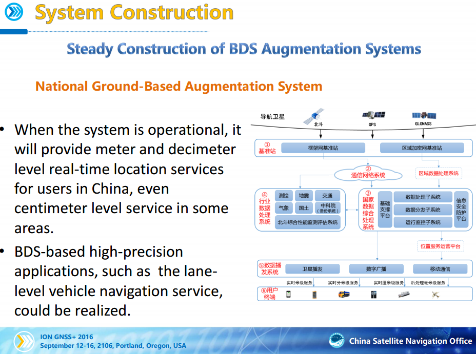
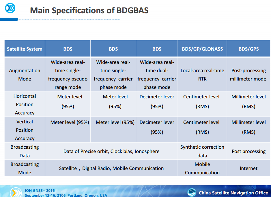
BDS will keep improving its nationwide reference station network and steadily enhance its service performance. The dense reference stations for the nationwide frame network will be constructed by 2018, providing meter and decimeter level real-time location services for users in China, even centimeter level service in some areas.

BDS will carry out the design, validation and construction of SBAS in accordance with international civil aviation standards. The first GEO satellite of BDSBAS will be launched in around 2018. The satellite-based augmentation services covering China and surrounding regions will be provided from 2020, to provide CAT-I services to civil aviation users.

The free civilian service has a 10-meter location-tracking accuracy, synchronizes clocks with an accuracy of 10 nanoseconds, and measures speeds to within 0.2 m/s. The restricted military service has a location accuracy of 10 centimetres, can be used for communication, and will supply information about the system status to the user. To date, the military service has been granted only to the People's Liberation Army and to the Military of Pakistan.

BeiDou's current accuracy is about 10 meters compared to the US GPS's 1 meter.

China aims to improve the system a hundred-fold that it would be more accurate than the popular American GPS.

China is developing ground based augmentation to achieve centimeter realtime accuracy and millimeter accuracy for post processing within cities like Beijing


http://www.nextbigfuture.com/2017/01/china-will-use-augmented-ground-systems.html
 
New notices shows a 24 hours slip to January 5.

A0044/17 - A TEMPORARY RESTRICTED AREA ESTABLISHED BOUNDED BY:N272159E1083650-N273125E1074313-N271528E1073946-N270603E1083315 BACK TO START.VERTICAL LIMITS:GND-UNL. GND - UNL, 05 JAN 15:08 2017 UNTIL 05 JAN 15:45 2017. CREATED: 04 JAN 09:14 2017

A0046/17 - A TEMPORARY RESTRICTED AREA ESTABLISHED BOUNDED BY: N260808E1142921-N261444E1140013-N255857E1135553-N255223E1142456 BACK TO START.VERTICAL LIMITS:GND-UNL. GND - UNL, 05 JAN 15:10 2017 UNTIL 05 JAN 15:56 2017. CREATED: 04 JAN 09:17 2017
 
China launches telecommunication technology test satellite
Xinhua, January 6, 2017

China successfully launched the No.2 telecommunication technology test satellite late Thursday night from the Xichang Satellite Launch Center in southwest China's Sichuan Province.

The satellite was launched at 11:18 p.m. by a Long March-3B carrier rocket.

2017010607083644264.jpg
The No.2 telecommunication technology test satellite is launched by a Long March-3B carrier rocket from the Xichang Satellite Launch Center in southwest China's Sichuan Province on Thursday night, January 5, 2017. [Photo: mod.gov.cn]
 
Ground-based large-scale electromagnetic launch system

China, or rather CASIC, aims to build a demonstration system and complete proof-of-principle test by 2020

The system will be employed for the launch of

(1) Yuzhou series of electric rockets(upper stages)
(2) Qingzhou series of liquid-fuel rockets(upper stages)

A variant for military purpose. ie. for launching missiles especially the hypersonic kind, is also under development.:enjoy:

Looking forward to some cool stuff in the next few years. :lol:
 
Last edited:
China launches telecommunication technology test satellite
Xinhua, January 6, 2017

China successfully launched the No.2 telecommunication technology test satellite late Thursday night from the Xichang Satellite Launch Center in southwest China's Sichuan Province.

The satellite was launched at 11:18 p.m. by a Long March-3B carrier rocket.

2017010607083644264.jpg
The No.2 telecommunication technology test satellite is launched by a Long March-3B carrier rocket from the Xichang Satellite Launch Center in southwest China's Sichuan Province on Thursday night, January 5, 2017. [Photo: mod.gov.cn]

Weighing well over 5 tons, the satellite is pretty close to the carrying capacity of the LM-3B carrier rocket. :D

Telecommunication technology test satellite?

You are a fool if you believe that just because the article says so:lol::lol:
 
A0049/17 - A TEMPORARY RESTRICTED AREA ESTABLISHED BOUNDED BY:N304059E0974550-N304323E0973336-N312020E0974316-N311756E0975534 BACK TO START. VERTICAL LIMITS:GND-UNL. GND - UNL, 09 JAN 04:12 2017 UNTIL 09 JAN 05:22 2017. CREATED: 05 JAN 06:04 2017

Kuaizhou-1A launch with several sats - JSLC - January 6, 2017


中国航天 - 通信技术试验卫星二号发射成功
TJSW-2 - CZ-3B - Xichang - January 5, 2017

2 objects have been cataloged by USTRATCOM

2017-001A/41911 in 222 x 35823 km x 27.49° (S/C)
2017-001B/41912 in 164 x 34340 km x 27.46° (CZ-3B 3rd stage)


http://www.expace.com.cn/index_16.aspx
 
Otherwise known as Huoyan(Fireeye)-1, the recently launched TJSW-2 is a missile early-warning satellite. :D

What's next?

Fireye-HEO? :D:D
The Americans had long suspected this even for the first TJSW.
 
New map of the Moon under creation in China
2017-01-05 15:47 | Xinhua | Editor: Gu Liping

Chinese scientists are drawing a 1:2.5 million scale geological map of the Moon.

Ouyang Ziyuan, first chief scientist of China's lunar exploration program, said five universities and research institutes have set standards for digital mapping and drawing of the Moon's geological structure.

A sketch version of the map, 4.36 meters by 2.2 meters, will be finished by 2018, and released by 2020.

The map will provide information on geology, structure and rock types and will reflect the timeline of the Moon's evolution.

Chen Shengbo, a geologist with Jilin University in northeast China's Jilin Province, and his team are responsible for drawing the lunar structure outline, just one part of the work. He said the map would clearly show lunar geography such as geographic fractures and the size, appearance, and the structure of craters.

Chen said mapping depends on data and images sent by circumlunar satellites from home and abroad. Lunar map making is not like drawing a map of the Earth, where scientists can go to the scene in person if they are not sure of their information.

China's satellites have captured global images of the Moon, which contribute to the precision of lunar maps.
 
According to China Aerospace Science and Industry Corp's official news: the Corp is now developing very powerful electromagnetic catapult to launch rockets into space.

There are two series of rockets under developement, including the Qingzhou series liquid fueled rocket and Yuzhou series electric hyprid rockets, will be designed to launch from electromagnetic catapult.

Huge and very powerful electromagnetic catapult can greatly reduce the cost to payload ratio and launch time, and make building huge space structure like very huge space stations or even space city/spaceship/death star in sci-fi movies economcily feasible.

It will be a huge leap-forward in human being's space development.:enjoy:

http://mil.sohu.com/20170108/n478084298.shtml

China's nearest competitor, the US, now struggle to developing properly EMAL to launch aircrafts in CVs or launch a few kg's weight bullets etc, whilst China is developing electromagnetic catapult launch tens of tonnes -weight rockets to space, so it is safe to say that China's electromagnetic catapult is likely leave the US in the dusts again.:enjoy:
 
Back
Top Bottom