What's new

Will the US defend Philippines if China attacks?

Some thing gets lost in all the "look i have an 800 year old piece of paper that says its mine"

Its all bluff.

There is all the demands and threats and single ship arge barge but behind all the bluster is the simple fact.

China does not have a blue water navy, the US doesnt have to defend the Philipines China is incapable of a prolonged sucessfull attack 2000 kilometers away at the moment Chinas navy is a littoral defence force.

When China has this all bets are off.

800px-Abraham-Lincoln-battlegroup.jpg
 
Ancient Maps in the modern world governed by rules = epic fail.

Mongolia, Italy and Spain would be fighting for the world right now if they'll follow logic of the Chinese. LOL!

I will take care of their "historical evidence", dont worry, dude.


International arbitration is for legitimate disputes. The Philippines doesn't have a leg to stand on. You do not arbitrate islands that have belonged to China for 2,000 years. It's like saying you want to arbitrate Taiwan. The idea is preposterous.

In Yesterday 11:49 PM, I said:
---
Even they use their "history", they will still loose to us, believe me. Because I don't even think that they really have any "historical evidence(s)". It will take years to make them post an legal "historical evidence" that prove their sovereignty (not some kind of "we found it first" or "we went fishing there first", exactly they need "we set sovereignty on it first"). I haven't seen any of them since June 2011.
---

Ocean-faring Chinese explorers had claimed the Spratly Islands a thousand years ago.
When? Where? How?

"Ancient Chinese maps record the "Thousand Li Stretch of Sands"; Qianli Changsha (千里長沙) and the "Ten-Thousand Li of Stone Pools"; Wanli Shitang (萬里石塘),[7] which China today claims refers to the Spratly Islands.
Where? Show me that map.

The Wanli Shitang have been explored by the Chinese since the Yuan Dynasty and may have been considered by them to have been within their national boundaries. [8][9] They are also referenced in the 13th century,[10] followed by the Ming Dynasty.[11]

Can you just a little bit more kind :rofl: Why you just always put "exploring" on the same as "setting sovereignty" :rofl:

When the Ming Dynasty collapsed, the Qing Dynasty continued to include the territory in maps compiled in 1724,[12] 1755,[13] 1767,[14] 1810,[15] and 1817.[16]
Again, where? Show me.

A Vietnamese map from 1834 also includes the Spratly Islands clumped in with the Paracels (a common occurrence on maps of that time) labeled as "Wanli Changsha".[17]"
Many Vietnamese and Western maps in 18,19th Century mentioned Spartly as "Vạn Lý Trường Sa" ("Wanli Changsha" in Han Chinese writing). Some mentioned Paracels as "Cát Vàng"


I don't even think it's Paracel. Too close. Just point out where is it in that map?

By the twelfth century, names for the South China Sea islands began to appear. The Paracels and the Spratlys were referred to more consistently as Changsha and Shitang. By the mid-fourteenth century, Shitang could be accurately identified as the Spratlys. There is also evidence of Chinese naval control over some areas of the South China Sea, which resulted in complete Chinese dominion of the South China Sea in the late thirteenth century. Finally, in the fifteenth century, Zheng He's seven voyages placed the South China Sea islands on the official navigational charts. In this map, the Xisha Islands are called Shitang, and the Nansha Islands are referred to as Wansheng Shitang Yu.

Yeah yeah you named the Sun so the Sun is your territory :rofl: :rofl:

4FpGz.jpg

The Map of South and East Ocean Sea Routes was drawn in between 1712-1721 by Qing (Ching) Dynasty Fujian (Fuchien) Province Navy Commander Shi Shibiao, the son of a famous Qing Dynasty imperial officer. This map clearly shows the sea routes, time, and descriptions from Chinese coastal ports to Japan, Laos, Vietnam, Indonesia, Brunei, Cambodia and the Philippines. On this map, the locations and names of the Southern Sea Islands (Nanhai Zhudao) are very accurate. The map shows Chinese sovereignty over the South China Sea islands (including Nansha Islands, Xisha Islands, Zhongsha Islands and Dongsha Islands).

Only one map?
Sound like your Qing dynasty had given up your territory in 1904:
Vietnam latest news - Thanh Nien Daily | 1904 China map admits Paracel, Spratly not Chinese territory


rHQ1x.jpg

1834 Vietnamese map showed the islands as Chinese "Wanli Changsha."

Lol, Vietnamese used Han Chinese to write that time, so? :rofl: "Wanli Changsha" is Vạn Lý Trường Sa in Vietnamese, so what's your point?

Mongolia, Italy, and Spain can choose to give up their sovereignty.

China chooses to retain its sovereignty.

Different countries are free to make different choices with their sovereignty.

Vietnam latest news - Thanh Nien Daily | 1904 China map admits Paracel, Spratly not Chinese territory

So what is that?
 
International arbitration is for legitimate disputes. The Philippines doesn't have a leg to stand on. You do not arbitrate islands that have belonged to China for 2,000 years. It's like saying you want to arbitrate Taiwan. The idea is preposterous.

----------


Spratly Islands have belonged to China since ancient times

Ocean-faring Chinese explorers had claimed the Spratly Islands a thousand years ago.

[Source: Wikipedia article on Spratly Islands with primary sources listed in footnotes]

"Ancient Chinese maps record the "Thousand Li Stretch of Sands"; Qianli Changsha (千里長沙) and the "Ten-Thousand Li of Stone Pools"; Wanli Shitang (萬里石塘),[7] which China today claims refers to the Spratly Islands. The Wanli Shitang have been explored by the Chinese since the Yuan Dynasty and may have been considered by them to have been within their national boundaries. [8][9] They are also referenced in the 13th century,[10] followed by the Ming Dynasty.[11] When the Ming Dynasty collapsed, the Qing Dynasty continued to include the territory in maps compiled in 1724,[12] 1755,[13] 1767,[14] 1810,[15] and 1817.[16] A Vietnamese map from 1834 also includes the Spratly Islands clumped in with the Paracels (a common occurrence on maps of that time) labeled as "Wanli Changsha".[17]"

AYyG4.jpg

By the twelfth century, names for the South China Sea islands began to appear. The Paracels and the Spratlys were referred to more consistently as Changsha and Shitang. By the mid-fourteenth century, Shitang could be accurately identified as the Spratlys. There is also evidence of Chinese naval control over some areas of the South China Sea, which resulted in complete Chinese dominion of the South China Sea in the late thirteenth century. Finally, in the fifteenth century, Zheng He's seven voyages placed the South China Sea islands on the official navigational charts. In this map, the Xisha Islands are called Shitang, and the Nansha Islands are referred to as Wansheng Shitang Yu.

4FpGz.jpg

The Map of South and East Ocean Sea Routes was drawn in between 1712-1721 by Qing (Ching) Dynasty Fujian (Fuchien) Province Navy Commander Shi Shibiao, the son of a famous Qing Dynasty imperial officer. This map clearly shows the sea routes, time, and descriptions from Chinese coastal ports to Japan, Laos, Vietnam, Indonesia, Brunei, Cambodia and the Philippines. On this map, the locations and names of the Southern Sea Islands (Nanhai Zhudao) are very accurate. The map shows Chinese sovereignty over the South China Sea islands (including Nansha Islands, Xisha Islands, Zhongsha Islands and Dongsha Islands).

rHQ1x.jpg

1834 Vietnamese map showed the islands as Chinese "Wanli Changsha."

[Note: Thank you to HuziHaidao12 for the first two pictures and captions.]

Stop lies.
The book written in China, printed 1961 about Zheng He's voyages included the map, it showed that he was'nt in Islands of Vietnam.
In the past chinese acepted East Sea (SCS) belong to Vietnam. Old map of China stated 交址洋, Sea of Giao Chỉ, Giao Chi (Kochi) was old name of Vietnam.


Source: http://www.defence.pk/forums/china-...ina-sea-news-discussions-7.html#ixzz224MzAHeR

country-giao-chi-vietnam-today-giao-chi-sea-china-ancient-book-ma.jpg
 
I hate to break it to you guys. No Western scholar has challenged China's first discovery and claim of the South China Sea islands from the Han Dynasty and onwards.

Did you read my citation of Chinese relics found on the South China Sea islands from the Yuan Dynasty (1271-1368)?

Chinese relics can be found all over the South China Sea and on the islands themselves. The South China Sea has been China's backyard for 2,000 years.

----------

There are 2,000 years of Chinese imperial records and maps. Chinese skeletons were physically discovered on the South China Sea islands. The Chinese pottery/bowls were also found on the South China Sea islands.

Some of the larger South China Sea islands have Chinese-built wells.

The evidence is overwhelming and irrefutable.

Want me to start going through them one by one? I can give you screen captures from the documentary videos of the archaeological digs on the South China Sea islands. Some of the Chinese-built wells have been there a long time.

I have never heard of an old Vietnamese or Filipino well on any of the South China Sea islands.

Below, I have provided a citation of Chinese relics from the Yuan Dynasty (1271-1368) found near Hsisha Islands in the South China Sea. Can any Vietnamese or Filipino provide a reputable citation of Vietnamese or Filipino relics in the South China Sea that predates 1368? If you can't, you have just admitted to Chinese sovereignty over the South China Sea islands.

----------

http://www.chinatravel.ws/china-guide/chinese-archeology/

"32 cultural relics discovered in South China Sea

HBizf.jpg


Archaeological teams have discovered Yuan dynasty blue and white porcelain for the first time in the South China Sea along with 32 newly-discovered ancient sites near Hsisha Islands, the 2010 South China Sea underwater archaeological team announced on June 1.

After 35 days of underwater archaeological work, South China Sea underwater archaeology team discovered 32 underwater cultural relics and found blue and white porcelain of Yuan Dynasty in South China Sea for the first time.

Source:Xinhua News"

[Note: China's Yuan Dynasty was from 1271-1368 (see http://www.travelchinaguide.com/intro/history/yuan/)]
 
If you Chinese want some "historical evidence" argument, let's rock and roll.

AnNamDaiQuocHoaDo.jpg

Hoang-Sa-Truong-Sa-giaoduc.net%20(1)_copy.JPG

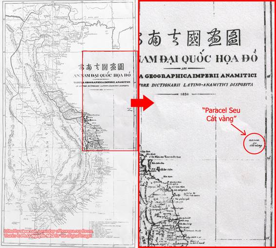
1838 maps using Western latest technique and Vietnamese older technique

Hoang-Sa-Truong-Sa-giaoduc.net%20(7)_copy.JPG

Western map, 1774

Vietnam-1754.jpg


Western map, 1754

1_7_1343533503_99_10.jpg

Western map 1735

hoang-sa22.jpg

Western map 1760

Hoang-Sa-Truong-Sa-giaoduc.net%20(5)_copy.JPG

Hoang-Sa-Truong-Sa-giaoduc.net%20(6)_copy.JPG

1776 book that described about our "Paracel Teams". Their misson was settling the sovereignty over Paracel, patrolling and exploiting in Paracel. They had been doing that continuously for hundreds years, until the French came. Then the French and Vietnamese pro-France officials replace them and live there continuously until the time when French were kicked out of Vietnam

---
Traité élémentaire de géographie: contenant un abrégé méthodique de Précis ... - Conrad Malte-Brun - Google Books
The French book "Traité élémentaire de géographie: contenant un abrégé méthodique du Précis de la géographie universelle en huit volumes" (volume 2) was published in Paris, 1831. Page 221 said that: "equal-spaced between Hainan and Cochinchina, Paracels archipelago was depended on Annam Empire". "A une egale distance de la cote de Cochinchine et de l'ile d'Hai-nan, l'archipel de Paracels est une dependance de l'empire d'Annam"
---


---
http://hoangsa.org/forum/downloads/37974-Modern_geography.pdf
“Modern geography: A description of the empires, kingdoms, states, and colonies with the oceans, seas, and isles” is pulished in Philadenphia, 1804. The author is John Pinkerton. In the Volume 2, at page 178, Paracels was described as a feature of the Cochin-China kingdom.
---


---
http://hoangsa.org/forum/downloads/45585-Algemeen_aardrijkskundig_woordenboek_tweede_deel.pdf
This is a historial book printed in Amsterdam and Leiden, 1772. In chapter XV at pages 647 to 674, the book treats of Cochin-China and islands of this country such as Pullo Sicca, Pullo Secca de Mare, Pullo Cambir, Pullo Canto. Especially, Paracels has been considered as initial part of Pullo Secca de Mare island chain. In the ancient maps, Paracels was used to draw like tail of scorpion extanding as far as Poulo Cerci de Mer forming Pullo Secca de Mare.
---


---
Nuovo dizionario geografico universale statistico-storico-commerciale ... - Google Books
The Italian geographic dictionary "Nuovo dizionario geografico universale statistico-storico-commerciale" was published in Venezia, 1831, based on documents of famous geographers: Balbi, Cannabich, Malte-Brun, Pinkerton ... In the volume 4, part 1, at the page 680, they describes that the Paracels was equal-spaced between Hainan and Cochinchina, and the sovereignty over it belongs to Annam kingdom.
---


---
Neues Konversations-Lexikon: ein Wörterbuch des allgemeinen Wissens ... - Herrmann Julius Meyer - Google Books
The German book "Neues Konversations-Lexikon: ein Wörterbuch des allgemeinen Wissens" was written by Herrmann Julius Meyer, published in Germany, 1866. At the page 575, they said that Paracels belongs to Cochinchina, Annam.
---


---
http://hoangsa.org/forum/downloads/65509-Principios_generales_de_geograf__a_matem.pdf
Spanish books printed in Barcelona in 1832 for Compania Mayoly Juaquin, including: "Principios generales de geografía matematíca ó Cosmografía", "Nociones de geografía Fisíca y de geografía Política", "La geografia moderna", "Espana en la mano, en la que se la trata", "La geografia antígua comparada con la moderna". The Paracels belong to Cochin China was confirmed in page 57 of the book "La geografia moderna"
---

---
Remember that Vietnam already pitched the flag in 1816
https://spreadsheets.google.com/ccc...qMGZ0TkpCTHZ6TVE&hl=en&authkey=COyTzIwK#gid=0
The Italian book "Del vario grado d'importanza degli stati odierni" was published in Milano, 1841. Page 421 mentions about the event Gia Long emperor pitch the flag to own Paracels in 1816, but Paracels belongs to Cocochina many years ago, according to Western documents.
---


I have more than 100 old Western books which affirm Vietnamese sovereign over Paracels, pm me if you need some more evidences. It means that when the Westerners came, they saw that Vietnamese govs and people are administrating Paracels archipelago, not Chinese. Then they wrote what they saw.
In "historical" side, I have more historical maps and text, it means I have more evidence, and I choose to use international laws. If you are confident in your historical evidences, why don't we go to international court, instead of your effort in trying to avoid the court all the time?
 
I hate to break it to you guys. No Western scholar has challenged China's first discovery and claim of the South China Sea islands from the Han Dynasty and onwards.
Nah just gave me your Han Dynasty claim first :coffee: What book, what map, what does it say ... I have been waiting for a year so long :coffee:

Did you read my citation of Chinese relics found on the South China Sea islands from the Yuan Dynasty (1271-1368)?
Chinese relics can be found all over the South China Sea and on the islands themselves. The South China Sea has been China's backyard for 2,000 years.
There are 2,000 years of Chinese imperial records and maps. Chinese skeletons were physically discovered on the South China Sea islands. The Chinese pottery/bowls were also found on the South China Sea islands.

Sunk ships, skeletons ...
Chinese seem like prefer to claim lands where their people died rather than where their people lived :coffee:

Some of the larger South China Sea islands have Chinese-built wells.

The evidence is overwhelming and irrefutable.

Want me to start going through them one by one? I can give you screen captures from the documentary videos of the archaeological digs on the South China Sea islands. Some of the Chinese-built wells have been there a long time.

I have never heard of an old Vietnamese or Filipino well on any of the South China Sea islands.

Below, I have provided a citation of Chinese relics from the Yuan Dynasty (1271-1368) found near Hsisha Islands in the South China Sea. Can any Vietnamese or Filipino provide a reputable citation of Vietnamese or Filipino relics in the South China Sea that predates 1368? If you can't, you have just admitted to Chinese sovereignty over the South China Sea islands.

You Chinese have even found Vietnamese Dong Son Bronze Drum in Guangdong, Guangxi, Yunnan. Should we claim those lands now? :coffee:
 
Relics belong to goods of trading vessels from India. Middle East are broken by stroms, skletons is not evident they are chinese controled tha Islands in the past, if it any with ADN, there was sailors of such India or Arab ships.
Chinese skeletons buried, is available in Hanoi, Dongda hill, where Qing Man soldiers was killed when they invaded Hanoi in the past, the last is the year 1789.. Trận Đống Đa - Thăng Long (30/1/1789).

Source: http://www.defence.pk/forums/china-...ina-sea-news-discussions-7.html#ixzz224WoD7n2

Hey, they will claim Hanoi and other places where they were defeated for that reason :fie:

---------------
Check out Chinese official map which prove that China doesn't own Paracel

1_7_1343533502_92_1.jpg

Yuan Dynasty

1_7_1343533503_06_2.jpg

Ming Dynasty 1461

1_7_1343533503_19_3.jpg

Ming Dynasty 1635

1_7_1343533503_33_3b.jpg

Qing 1862

1_7_1343533503_46_4.jpg

Qing 1897

1_7_1343533503_61_5.jpg

Qing 1909
 
Some thing gets lost in all the "look i have an 800 year old piece of paper that says its mine"

Its all bluff.

There is all the demands and threats and single ship arge barge but behind all the bluster is the simple fact.

China does not have a blue water navy, the US doesnt have to defend the Philipines China is incapable of a prolonged sucessfull attack 2000 kilometers away at the moment Chinas navy is a littoral defence force.

When China has this all bets are off.

800px-Abraham-Lincoln-battlegroup.jpg


China also has a strong carrier Varyag:
This is a latest photo of the carrier Varyag:

R2WFQ.jpg
 
China also has a strong carrier Varyag:
This is a latest photo of the carrier Varyag:
Not a real one. Besides, the Chinese version is not as capable. When a US carrier group sails, it is accompanied by 'blue water' subs. You can see four such wakes in post 151. China does not (yet) have such capable subs. So if the Chinese carrier takes on a fight with the US, it will be sunk, probably AFTER it launched its fighters and they will have nowhere to land.
 
Not a real one. Besides, the Chinese version is not as capable. When a US carrier group sails, it is accompanied by 'blue water' subs. You can see four such wakes in post 151. China does not (yet) have such capable subs. So if the Chinese carrier takes on a fight with the US, it will be sunk, probably AFTER it launched its fighters and they will have nowhere to land.
oh c'mon, now you're just shattering some megaton dreams:P
 
Do I need to repost my citation of Secretary of State Clinton saying, "U.S. has no territorial claims in the South China Sea and will remain neutral"?

Guys, this is a professional defense forum. We do not engage in fantasy scenarios. The U.S. cavalry isn't coming for communist Vietnam or the Philippines.
 
Do I need to repost my citation of Secretary of State Clinton saying, "U.S. has no territorial claims in the South China Sea and will remain neutral"?

And the next US SecState will say: "While the US have no territorial claims in the region, the US is committed to free trade and sea lanes access through the region. The US will commit to the defense of said freedom and will not allow China to control the region."

Guys, this is a professional defense forum. We do not engage in fantasy scenarios. The U.S. cavalry isn't coming for communist Vietnam or the Philippines.
That is hilarious coming from someone who made all kinds of wild fantasy scenarios for the J-20. Many of them defied the laws of nature.
 
Do I need to repost my citation of Secretary of State Clinton saying, "U.S. has no territorial claims in the South China Sea and will remain neutral"?

Guys, this is a professional defense forum. We do not engage in fantasy scenarios. The U.S. cavalry isn't coming for communist Vietnam or the Philippines.

Avoid my points again ... Not surprise, you have done it for a year long :sick:
You Chinese just don't have a single base of your buffalo's tongue claim.
 
Back
Top Bottom