How to install the app on iOS
Follow along with the video below to see how to install our site as a web app on your home screen.
Note: This feature may not be available in some browsers.
You are using an out of date browser. It may not display this or other websites correctly.
You should upgrade or use an alternative browser.
You should upgrade or use an alternative browser.
Island crops out in Gwadar sea after earthquake
- Thread starter Patriots
- Start date
Spring Onion
PDF VETERAN

- Joined
- Feb 1, 2006
- Messages
- 41,403
- Reaction score
- 19
- Country
- Location
Whats new in it?
It will go down in a year time.
It will go down in a year time.
Armstrong
RETIRED TTA

- Joined
- Feb 2, 2012
- Messages
- 19,390
- Reaction score
- 94
- Country
- Location
Whats new in it?
It will go down in a year time.
The term 'Bearded Buff00ns' had my copyright on it !

Spring Onion
PDF VETERAN

- Joined
- Feb 1, 2006
- Messages
- 41,403
- Reaction score
- 19
- Country
- Location
The term 'Bearded Buff00ns' had my copyright on it !
I don't know when you used it but I have invented it three years back on google forum for seniors where all oldies are either bankers, intellectuals, retired Generals and so on.
I was given specially permission to enter the forum

Since then BB(Bearded Baff00ns, Bearded Baboons) is widely used by them
Edevelop
ELITE MEMBER

- Joined
- Feb 2, 2007
- Messages
- 14,735
- Reaction score
- 23
- Country
- Location
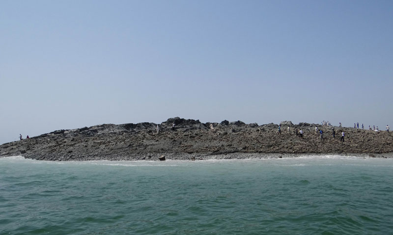
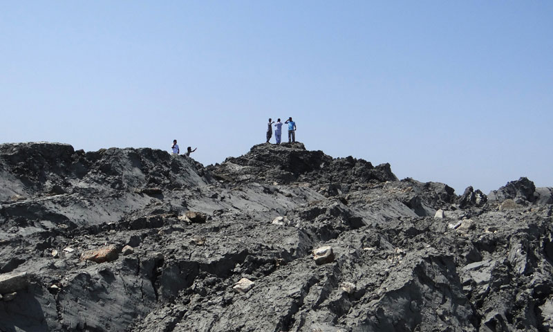
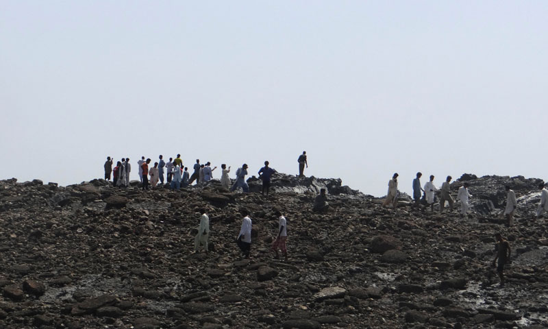
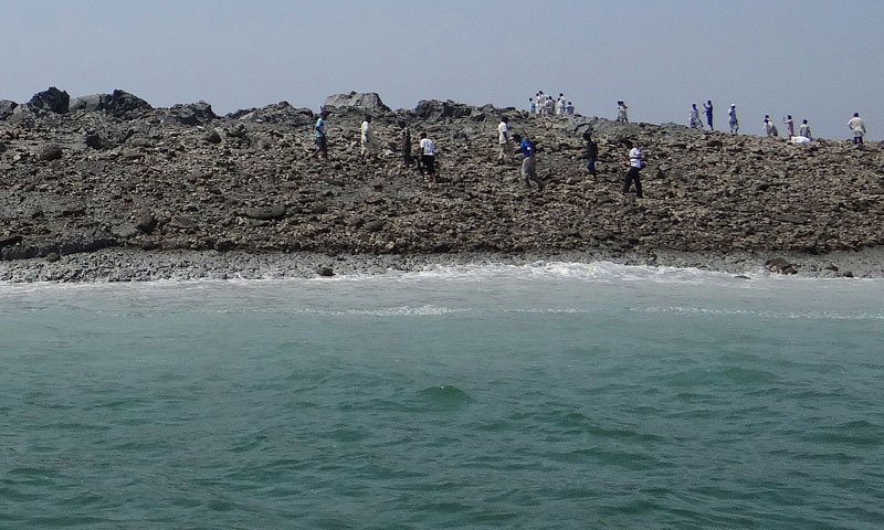
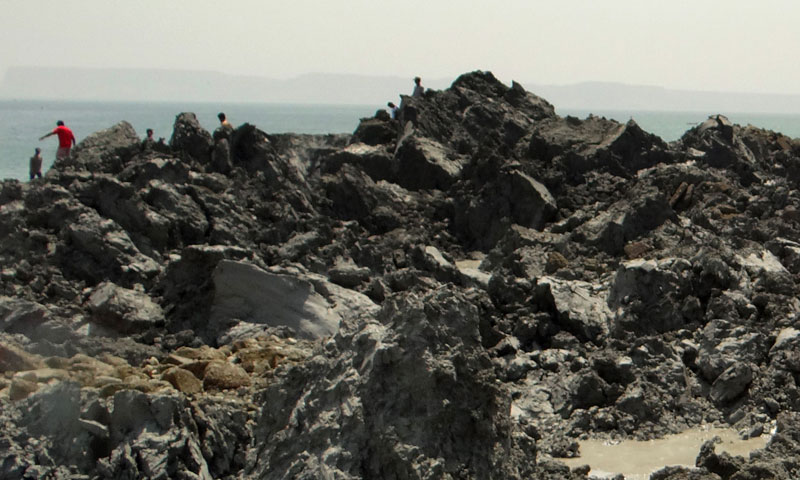
Gwadar's quake island unlikely to last: experts
GWADAR: A small island created in the Arabian Sea by the huge earthquake that hit southwest Pakistan has fascinated locals but experts say it is unlikely to last long.
The 7.7-magnitude quake struck on Tuesday in Balochistan’s remote Awaran district, killing more than 260 people and affecting hundreds of thousands.
Off the coastline near the port of Gwadar, some 400 kilometres from the epicentre, locals were astonished to see a new piece of land surface from the waves.
“It is not a small thing, but a huge thing which has emerged from under the water,” Gwadar resident Muhammad Rustam told news agency AFP. “It looked very, very strange to me and also a bit scary because suddenly a huge thing has emerged from the water.”
Mohammad Danish, a marine biologist from Pakistan’s National Institute of Oceanography, said a team of experts had visited the island and found methane gas rising.
“Our team found bubbles rising from the surface of the island which caught fire when a match was lit and we forbade our team to start any flame. It is methane gas,” Danish said on a local television news channel.
The island is about 60 to 70 feet (18 to 21 metres) high, up to 300 feet wide and up to 120 feet long, he said. It sits about 200 metres away from the coast.
Gary Gibson, a seismologist with Australia’s University of Melbourne, said the new island was likely to be a “mud volcano”, created by methane gas forcing material upwards during the violent shaking of the earthquake.
“It’s happened before in that area but it’s certainly an unusual event, very rare,” Gibson told AFP, adding that it was “very curious” to see such activity some 400 kilometres from the quake’s epicentre.
The so-called island is not a fixed structure but a body of mud that will be broken down by wave activity and dispersed over time, the scientist said.
A similar event happened in the same area in 1945 when an 8.1-magnitude earthquake at Makran triggered the formation of mud volcanoes off Gwadar.
Professor Shamim Ahmed Shaikh, chairman of the department of geology at Karachi University, said the island, which has not been named, would disperse within a couple of months.
He said it happens along the Makran coast because of the complex relationship between tectonic plates in the area. Pakistan sits close to the junction of three plates – the Indian, Arabian and Eurasian.
“About a year back an island of almost similar size had surfaced at a similar distance from the coast in the Makran region. This would disperse in a week to a couple of months,” Shaikh told AFP.
Gibson said the temporary island was very different from the permanent uplift seen during major “subduction zone” earthquakes, where plate collisions force the Earth’s crust suddenly and sometimes dramatically upwards.
For example, in the massive 9.5-magnitude earthquake in Chile in 1960 – known as the world’s largest ever – whole fishing villages were thrust “several metres” upwards and wharves suddenly located hundreds of metres inland, Gibson said.
Such uplift events are relatively common in the Pacific’s so-called “Ring of Fire”, a hotbed of seismic and volcanic activity at the junction of several tectonic plates.
A thundering 8.0-magnitude quake in the Solomon Islands in 2007 thrust Ranogga Island upwards by three metres, exposing submerged reefs once popular with divers and killing the vibrant corals, expanding the shoreline outwards by several metres in the process.
During the massive 9.2-magnitude earthquake off Sumatra which triggered a devastating tsunami across the Indian Ocean in 2004, several islands were pushed upwards while others subsided into the ocean.
The Aceh coast dropped permanently by one metre while Simeulue Island was lifted by as much as 1.5 metres, exposing the surrounding reef which became the island’s new fringe.
Gwadar's quake island unlikely to last: experts - DAWN.COM
W.11
BANNED

- Joined
- Jan 20, 2011
- Messages
- 15,032
- Reaction score
- -32
- Country
- Location


Gwadar's quake island unlikely to last: experts
GWADAR: A small island created in the Arabian Sea by the huge earthquake that hit southwest Pakistan has fascinated locals but experts say it is unlikely to last long.
The 7.7-magnitude quake struck on Tuesday in Balochistan’s remote Awaran district, killing more than 260 people and affecting hundreds of thousands.
Off the coastline near the port of Gwadar, some 400 kilometres from the epicentre, locals were astonished to see a new piece of land surface from the waves.
“It is not a small thing, but a huge thing which has emerged from under the water,” Gwadar resident Muhammad Rustam told news agency AFP. “It looked very, very strange to me and also a bit scary because suddenly a huge thing has emerged from the water.”
Mohammad Danish, a marine biologist from Pakistan’s National Institute of Oceanography, said a team of experts had visited the island and found methane gas rising.
“Our team found bubbles rising from the surface of the island which caught fire when a match was lit and we forbade our team to start any flame. It is methane gas,” Danish said on a local television news channel.
The island is about 60 to 70 feet (18 to 21 metres) high, up to 300 feet wide and up to 120 feet long, he said. It sits about 200 metres away from the coast.
Gary Gibson, a seismologist with Australia’s University of Melbourne, said the new island was likely to be a “mud volcano”, created by methane gas forcing material upwards during the violent shaking of the earthquake.
“It’s happened before in that area but it’s certainly an unusual event, very rare,” Gibson told AFP, adding that it was “very curious” to see such activity some 400 kilometres from the quake’s epicentre.
The so-called island is not a fixed structure but a body of mud that will be broken down by wave activity and dispersed over time, the scientist said.
A similar event happened in the same area in 1945 when an 8.1-magnitude earthquake at Makran triggered the formation of mud volcanoes off Gwadar.
Professor Shamim Ahmed Shaikh, chairman of the department of geology at Karachi University, said the island, which has not been named, would disperse within a couple of months.
He said it happens along the Makran coast because of the complex relationship between tectonic plates in the area. Pakistan sits close to the junction of three plates – the Indian, Arabian and Eurasian.
“About a year back an island of almost similar size had surfaced at a similar distance from the coast in the Makran region. This would disperse in a week to a couple of months,” Shaikh told AFP.
Gibson said the temporary island was very different from the permanent uplift seen during major “subduction zone” earthquakes, where plate collisions force the Earth’s crust suddenly and sometimes dramatically upwards.
For example, in the massive 9.5-magnitude earthquake in Chile in 1960 – known as the world’s largest ever – whole fishing villages were thrust “several metres” upwards and wharves suddenly located hundreds of metres inland, Gibson said.
Such uplift events are relatively common in the Pacific’s so-called “Ring of Fire”, a hotbed of seismic and volcanic activity at the junction of several tectonic plates.
A thundering 8.0-magnitude quake in the Solomon Islands in 2007 thrust Ranogga Island upwards by three metres, exposing submerged reefs once popular with divers and killing the vibrant corals, expanding the shoreline outwards by several metres in the process.
During the massive 9.2-magnitude earthquake off Sumatra which triggered a devastating tsunami across the Indian Ocean in 2004, several islands were pushed upwards while others subsided into the ocean.
The Aceh coast dropped permanently by one metre while Simeulue Island was lifted by as much as 1.5 metres, exposing the surrounding reef which became the island’s new fringe.
Gwadar's quake island unlikely to last: experts - DAWN.COM
kya gand he yaar, buri khabar suna di he

khanboy007
FULL MEMBER

- Joined
- May 22, 2012
- Messages
- 1,180
- Reaction score
- 1
- Country
- Location


Gwadar's quake island unlikely to last: experts
GWADAR: A small island created in the Arabian Sea by the huge earthquake that hit southwest Pakistan has fascinated locals but experts say it is unlikely to last long.
The 7.7-magnitude quake struck on Tuesday in Balochistan’s remote Awaran district, killing more than 260 people and affecting hundreds of thousands.
Off the coastline near the port of Gwadar, some 400 kilometres from the epicentre, locals were astonished to see a new piece of land surface from the waves.
“It is not a small thing, but a huge thing which has emerged from under the water,” Gwadar resident Muhammad Rustam told news agency AFP. “It looked very, very strange to me and also a bit scary because suddenly a huge thing has emerged from the water.”
Mohammad Danish, a marine biologist from Pakistan’s National Institute of Oceanography, said a team of experts had visited the island and found methane gas rising.
“Our team found bubbles rising from the surface of the island which caught fire when a match was lit and we forbade our team to start any flame. It is methane gas,” Danish said on a local television news channel.
The island is about 60 to 70 feet (18 to 21 metres) high, up to 300 feet wide and up to 120 feet long, he said. It sits about 200 metres away from the coast.
Gary Gibson, a seismologist with Australia’s University of Melbourne, said the new island was likely to be a “mud volcano”, created by methane gas forcing material upwards during the violent shaking of the earthquake.
“It’s happened before in that area but it’s certainly an unusual event, very rare,” Gibson told AFP, adding that it was “very curious” to see such activity some 400 kilometres from the quake’s epicentre.
The so-called island is not a fixed structure but a body of mud that will be broken down by wave activity and dispersed over time, the scientist said.
A similar event happened in the same area in 1945 when an 8.1-magnitude earthquake at Makran triggered the formation of mud volcanoes off Gwadar.
Professor Shamim Ahmed Shaikh, chairman of the department of geology at Karachi University, said the island, which has not been named, would disperse within a couple of months.
He said it happens along the Makran coast because of the complex relationship between tectonic plates in the area. Pakistan sits close to the junction of three plates – the Indian, Arabian and Eurasian.
“About a year back an island of almost similar size had surfaced at a similar distance from the coast in the Makran region. This would disperse in a week to a couple of months,” Shaikh told AFP.
Gibson said the temporary island was very different from the permanent uplift seen during major “subduction zone” earthquakes, where plate collisions force the Earth’s crust suddenly and sometimes dramatically upwards.
For example, in the massive 9.5-magnitude earthquake in Chile in 1960 – known as the world’s largest ever – whole fishing villages were thrust “several metres” upwards and wharves suddenly located hundreds of metres inland, Gibson said.
Such uplift events are relatively common in the Pacific’s so-called “Ring of Fire”, a hotbed of seismic and volcanic activity at the junction of several tectonic plates.
A thundering 8.0-magnitude quake in the Solomon Islands in 2007 thrust Ranogga Island upwards by three metres, exposing submerged reefs once popular with divers and killing the vibrant corals, expanding the shoreline outwards by several metres in the process.
During the massive 9.2-magnitude earthquake off Sumatra which triggered a devastating tsunami across the Indian Ocean in 2004, several islands were pushed upwards while others subsided into the ocean.
The Aceh coast dropped permanently by one metre while Simeulue Island was lifted by as much as 1.5 metres, exposing the surrounding reef which became the island’s new fringe.
Gwadar's quake island unlikely to last: experts - DAWN.COM
knew it would vanish !!!!
but the government can collect the minerals on/from the island, because volcanic material is nutritious and good for crops and farming
fawwaxs
SENIOR MEMBER

- Joined
- Mar 31, 2009
- Messages
- 2,125
- Reaction score
- -2
- Country
- Location
Last edited by a moderator:
PlanetWarrior
SENIOR MEMBER

- Joined
- Oct 23, 2009
- Messages
- 6,096
- Reaction score
- -2
- Country
- Location
Ok. Here's the deal. India will stake no claim to this island. Pakistan in turn relinquishes all claim which it has to Kashmir 

W.11
BANNED

- Joined
- Jan 20, 2011
- Messages
- 15,032
- Reaction score
- -32
- Country
- Location
Ok. Here's the deal. India will stake no claim to this island. Pakistan in turn relinquishes all claim which it has to Kashmir
why? is this island on Kashmir's coast?
Last edited by a moderator:
Hyperion
RETIRED TTA

- Joined
- Jun 4, 2012
- Messages
- 12,564
- Reaction score
- 26
- Country
- Location
Lakh-de-lanat..... aakhir 60+ saal baad, banye wali baat karr dee na! 

As this island is not a muslim majority region, it belongs to India. India should officially include this in the long lost of disputes.
jaunty
SENIOR MEMBER

- Joined
- Aug 1, 2009
- Messages
- 6,566
- Reaction score
- -9
- Country
- Location
Lakh-de-lanat..... aakhir 60+ saal baad, banye wali baat karr dee na!
Aadat se majboor.

W.11
BANNED

- Joined
- Jan 20, 2011
- Messages
- 15,032
- Reaction score
- -32
- Country
- Location

Weird Island Appears After Pakistan Earthquake

A new island formed by a mud volcano emerged offshore of Balochistan, Pakistan on Nov. 26, 2010 in about the same area as yesterday's new island.
A new island emerged from the ocean offshore of the city of Gwadar, Pakistan, after a strong magnitude-7.7 earthquake shook the country yesterday (Sept. 24).
PLAY VIDEO
How Geysers Erupt
Geysers are more than just pretty eruptions of water and steam.
DCI
The mound appears to be 20 to 40 feet (6 to 12 meters) high and 100 feet (30 m) wide, DIG Gwadar Moazzam Jah, a district police officer, told Pakistan's Geo News. It rose out of the sea at a spot located about 350 feet (100 m) from the coast, he said.
Top 20 Reasons We're Not as Powerful as We Think
The news sparked lively chatter among geologists, who debated whether the hill was a landslide, a fault scarp or even a hoax. A fault scarp marks vertical displacement along a fault, anything from a small step to a huge, steep cliff.
Scientists are still far from consensus, but many think that Pakistan's newest piece of land may be a mud volcano.
Geologist Bob Yeats, an expert on Pakistan's earthquake hazards, said he's waiting until he hears from his colleagues in Pakistan before judging the case. The two most likely possibilities are a landslide or a mud volcano, Yeats told LiveScience's OurAmazingPlanet.
Yeats said Gwadar is several hundred kilometers southwest of the earthquake's epicenter, making it highly unlikely that the new island is a fault scarp.
NEWS: How Earth Heals Itself After an Earthquake
"(The island) is a long way from where they reported the earthquake. We're looking at two different things," said Yeats, an emeritus professor at Oregon State University.
A mud volcano is a likely possibility because Gwadar's coastline already has several of the gurgling, steamy cones, both onshore and at sea. One suddenly popped up where sea level was 30 to 60 meters (100 to 200 feet) deep on Nov. 26, 2010, creating an island. NASA satellites snapped a photo of the birth. (7 Ways the Earth Changes in the Blink of an Eye)
And in 1945, the magnitude-8.1 Makran temblor triggered the formation of mud volcanoes offshore of Gwadar, according to a study on mud volcanoes in Pakistan published in 2005. A recent study in the journal Nature Geoscience also suggests the 1945 earthquake released tons of methane from the seafloor.

The same area in 2009. NASA EARTH OBSERVATORY
Get ready to rumble
Mud volcanoes appear when sediments like silt and clay become pressurized by hot gas trapped underground. A subduction zone beneath Pakistan supplies the tectonic activity that heats and holds the gas. The Arabian and Eurasian tectonic plates collide offshore of Pakistan, forming a subduction zone, but today's earthquake was onshore and mostly strike-slip — each side of the fault moved horizontally.
PLAY VIDEO
How Geysers Erupt
Geysers are more than just pretty eruptions of water and steam.
DCI
The highest intensity shaking is marked in orange, near the epicenter of the Sept. 24 Pakistan earthquake.
USGS
Mud volcanoes burble up during earthquakes because the shaking releases mud and water that are trapped beneath barriers in seafloor sediments.
"For example, a clay or shale layer can be impermeable, but if fractured during an earthquake, could release mud and water that was under pressure below the layer. Or a water-rich clay layer could undergo liquefaction that would be released along fractures in the sediments," explained James Hein, a senior scientist with the U.S. Geological Survey in Santa Cruz, Calif. "Some think the island was there before the earthquake, and that would be very easy to check by looking at satellite photos of that area taken the week prior," he said.
But Geologist Dave Petley, a landslide expert, thinks the island's low, arcuate (or bow) shape — as seen in the few pictures released so far — suggests a rotational landslide, rather than a conical mud volcano. A rotational landslide moves along a rupture surface that is curved or concave, like the inside of a spoon.
ANALYSIS: 3 Million Earthquake Deaths for the 21st Century
At this point it is still too early. "It is really very strange, and the pictures are just too indistinct to be able to tell," said Petley, a professor at Durham University in the United Kingdom.
The Arabian Sea isn't the only spot on Earth to spout mud and gas when jiggled by earthquakes. In Japan, the town of Niikappu on the island of Hokkaido sports mud volcanoes that erupt after earthquakes, reports a study published in 1997 in the Journal of the Geological Society of Japan.
The world's most notorious mud volcano, Indonesia's Lusi, destroyed a town in 2006. It may have been caused by an earthquake or by drilling operations nearby.
NEWS: Catastrophic Mud Eruption Had Natural Causes
Earthquakes also rattle geysers and real volcanoes. The 2002 Denali earthquake in Alaska changed the spurting schedule of Yellowstone National Park's famous geysers for several months. And seismic shaking can sometimes cause a surge in eruptions at nearby volcanoes after an earthquake.
Email Becky Oskin or follow her @beckyoskin. Follow us @OAPlanet, Facebook & Google+. Original article on LiveScience's
Similar threads
- Replies
- 2
- Views
- 450
- Replies
- 9
- Views
- 925
- Replies
- 0
- Views
- 453


