What's new

Extreme Flood in Indus tributaries - 100s Die

Levees/Dykes are the only way out in flat topographical conditions. Which is how the countryside in Holland around Amsterdam exists. Maybe Orangzaib has overlooked that.
Levees help to retain the integrity of the river banks and the adjoining hinterland. In a densely populated area as West Punjab (there is nothing similar in USA) where is the vacant land to allow canals and lake systems to be created to absorb the run-off?
Are'nt there Levees around the Mississippi in USA to act as flood-control measures?


Actually; that is the irony of these disasters. The inundated rivers bring down huge amounts of silt with them. Which will increase the fertility of the flood-plains in the future.
May be that part is unavoidable and to some extent desirable.

What is really needed is: an early warning and evacuation system in places that are vulnerable apart from the flood levee system as you suggested, to protect inhabited areas.

Agreed. That's what I'm talking about!

image.png
 
Head Marala to Airport.jpg


For those of you who are discussing the possibility of lake for flood control, this is the possible site that I have demarcated with blue outline. If you notice, this area is bounded by Head Marala Barrage in the north, large canal that leads to Gujranwala and then to Ravi (on Head Baloki) as well as Sialkot airport on East and South East respectively, and River Chenab on the West.

As you can see, this is very rich agricultural land with dozens of villages. I would think that the cost of land would be around Rs. 2 million per acre. for this project, at least 100,000 acres might be required. That means an expense of 200 Billion rupees only to acquire land. This is quite prohibitive, because the actual implementation would cost much more than that. Added to this hassle would be loss of prime agricultural land.

This is not a feasible project. Its no use thinking about it.

Indian water terrorism.

What do you want them to do? Drink it all before it gets to Pakistan? If they build dams, we will have problem with it, if they do not build dam, people like you complain. What do you suggest they should do when a Himalayan river suddenly rises because of persistent rain?
 
More news about Head Trimmu:

GOVERNMENT OF PAKISTAN

PAKISTAN METEOROLOGICAL DEPARTMENT

FLOOD FORECASTING DIVISION

46-JAIL ROAD LAHORE


Sr.No.:16

Dated:Monday, September 08, 2014


SIGNIFICANT FLOOD FORECAST FOR RIVER CHENAB AT TRIMMU


In continuation of our previous Flood warning # 13.

Due to second flood peak in River Chenab, peak at Trimmu will likely to persist 24-48 hours further with a maximum flow upto 8,00,000 cusecs.

Exceptionally High Flood Level may continue upto 2100 PST of 12-09-2014.

Under this condition Districts Sargodha, Khushab , Jhang & Toba Taik Singh are likely to be inundated. All concerned authorities are requested to take all necessary measures to avoid any loss of life and property.


Time of issue: 11:30 PST


MUHAMMAD RIAZ

Chief Meteorologist

FFD, Lahore

042-99200139, 99205367

Distribution:

  1. Chief Minister, Punjab.
  2. Federal Minister, Water & Power, Islamabad.
  3. Chairman NDMA, Islamabad.
  4. D.G. Engineers, Eng. Directorate GHQ, Rawalpindi.
  5. Chairman, Federal Flood Commission, Islamabad.
  6. Chief Secretary, Punjab
  7. Secretary, Irrigation, Punjab.
  8. Chief Engineer Irrigation Punjab.
  9. Secretary, Aviation Division, Islamabad.
  10. Secretary, Ministry of Water & Power, Islamabad.
  11. PDMA’, Punjab.
  12. All other concerned
 
Agreed. That's what I'm talking about!
Dutch are famous all over the world for dredging and land reclaiming. See how is Netherlands and what they did.

From wikipedia: The Netherlands' name literally means "Low Country", inspired by its low and flat geography, with only about 50% of its land exceeding one metre above sea level. Most of the areas below sea level are man-made. Since the late 16th century, large areas (polders) have been reclaimed from the sea and from lakes, amounting to nearly 17% of the country's current land mass.

With a population density of 406 people per km² – 497 if water is excluded – the Netherlands is a very densely populated country for its size. Only Bangladesh, South Korea and Taiwan have both a larger population and a higher population density. Nevertheless, the Netherlands is the world's second largest exporter of food and agriculture products, after the United States.


Again i am not saying that copying and pasting what they did in the Netherlands will work in Pakistan, but i just want to point out that nothing is impossible only if there is a will to do something to address the issue.

Punjab is a plain land, or no dams can be build on chenab etc ..... are all just excuses for not doing anything for the common man and fooling him again and again.

If there are people who think it is not possible to solve the issue then there also equal number of engineers and experts if not more who can do things to avert such damage in the future, if not completely at least a big portion of it.

The Netherlands compared to sea-level

575px-The_Netherlands_compared_to_sealevel.png


And how they solved it: Flood control in the Netherlands - Wikipedia, the free encyclopedia
 
Last edited:
View attachment 47766

For those of you who are discussing the possibility of lake for flood control, this is the possible site that I have demarcated with blue outline. If you notice, this area is bounded by Head Marala Barrage in the north, large canal that leads to Gujranwala and then to Ravi (on Head Baloki) as well as Sialkot airport on East and South East respectively, and River Chenab on the West.

As you can see, this is very rich agricultural land with dozens of villages. I would think that the cost of land would be around Rs. 2 million per acre. for this project, at least 100,000 acres might be required. That means an expense of 200 Billion rupees only to acquire land. This is quite prohibitive, because the actual implementation would cost much more than that. Added to this hassle would be loss of prime agricultural land.

This is not a feasible project. Its no use thinking about it.


What do you want them to do? Drink it all before it gets to Pakistan? If they build dams, we will have problem with it, if they do not build dam, people like you complain. What do you suggest they should do when a Himalayan river suddenly rises because of persistent rain?

You are absolutely spot on in your assessment. The whole idea of dams and lakes is balderdash; the flat topography will make that totally unfeasible unless people wish to construct a Mega-Mega-Tank covering an expanse of some million acres in the guise of a dam.

In these topographical conditions of west Punjab and Sind; the only way out is to construct levees/dykes along the river-banks which will protect the river banks and adjoining hinterland. Obviously it cannot be done along the entire length of the banks (due to costs) neither should it be; the reason being that the river in spate brings down huge amounts of silt. In fact; if that silt is allowed to spread on the non-inhabited agricultural lands adjoining the rivers; the fertility of that land goes up mani-fold in the future. So these floods are a mixed evil.
What is required is protection of the inhabited settlements (by levees and dykes); and at the very least------ an early warning system so that people can be effectively and speedily evacuated in circumstances such as these.

Singing "Dams, Dams and more Dams" may be a meaningless tune.

Please also refer to the posts of @Syed.Ali.Haider above. He has also got the drift of the problem and the nature of the solution.

Indian water terrorism.

Paani Jihad; hunh???
 
How about building drains and diverting that water along with using that water to recharge ground water.
 
I am not sure if it is resting on that roof top. It could be an illusion because of photography.
Due to rain , floods,Those are fragile roof. Anyway great work by our army.... They are always on front in disaster situations.... Hundreds of villages are effected. Still flood will pass through many areas. This is very big disaster... Many people are hungry & demanding food. This is not new thing.Here flood comes after every 2,3 year... Our government should invest heavily in sewerage system. Where is Disaster management system... Their response is very fragile. We are going towards unimaginable loss in this disaster. Many People saved their life on trees, but few of them died due to snake bite. Nobody knows the real situation on ground. Some villages are demolished according to express news. People are crying for help but no help reached according to them. Such situation happens when we see non merit appointments, relatives of MNAs in key sectors ... That's why They doesn't care about public. Tune any channel expect ptv 1 & ptv2(geo news), villagers are crying for help & they are furious on government response. Today, Many hungry people blocked motorway due to this.
 
Last edited:
I may sound strange, but what if somehow during the flood season the extra water from the rivers is diverted to drought hit areas or barren land through:

1) Artificial rivers or huge canals. You can add numerous others things on he banks of this/these artificial river/s or canal/s for example, recreational, research , agriculture etc… There is investment but also there is also a lot of revenue generation oppurtunity.

or

2) pipies ending in huge canals or reservoirs in drought hit areas or barren land.

For example something like the below project but in reverse:
From Wikipedia: The Great Man-Made River (GMR, النهر الصناعي العظيم) is a network of pipes that supplies water to the Sahara Desert in Libya, from the Nubian Sandstone Aquifer System fossil aquifer. It is the world's largest irrigation project.

According to its website, it is the largest underground network of pipes (2,820 kilometres (1,750 mi)) and aqueducts in the world. It consists of more than 1,300 wells, most more than 500 m deep, and supplies 6,500,000 m3 of fresh water per day to the cities of Tripoli, Benghazi, Sirte and elsewhere. The late Libyan Leader Muammar Gaddafi described it as the "Eighth Wonder of the World."


In 1953, efforts to find oil in southern Libya led to the discovery of large quantities of fresh water underground. The Great Man-made River Project (GMRP) was conceived in the late 1960s and work on the project began in 1984. The project's construction was divided into five phases. The first phase required 85 million m³ of excavation and was inaugurated on 28 August 1991. The second phase (dubbed First water to Tripoli) was inaugurated on 1 September 1996.

The fossil aquifer from which this water is being supplied is the Nubian Sandstone Aquifer System. It accumulated during the last ice age and is not currently being replenished. If 2007 rates of retrieval are not increased, the water could last a thousand years. Independent estimates indicate that the aquifer could be depleted of water in as soon as 60 to 100 years. Analysts say that the costs of the $25 billion groundwater extraction system are 10% those of desalination.


Great Man-Made River - Wikipedia, the free encyclopedia


616px-Great_Man_Made_River_schematic_EN.svg.png
 
Last edited:
In continuation to my previous post

-------------------------

Saturday, 18 March 2006

_41453986_tar_bbc_416.jpg

The Grand Omar Mukhtar will be Libya's largest man-made reservoir

_41453938_pipe_bbc_203.jpg


_41454068_ajdab_bbc_203.jpg


Libyans like to call it "the eighth wonder of the world".

The description might be flattering, but the Great Man-Made River Project has the potential to transform Libyan life in all sorts of ways.

Libya is a desert country, and finding fresh water has always been a problem.

Following the Great Al-Fatah Revolution in 1969, when an army coup led by Muammar Al Qadhafi deposed King Idris, industrialisation put even more strain on water supplies.

Coastal aquifers became contaminated with sea water, to such an extent that the water in Benghazi (Libya's second city) was undrinkable.

Finding a supply of fresh, clean water became a government priority. Oil exploration in the 1950s had revealed vast aquifers beneath Libya's southern desert.

According to radiocarbon analysis, some of the water in the aquifers was 40,000 years old. Libyans call it "fossil water".

After weighing up the relative costs of desalination or transporting water from Europe, Libyan economists decided that the cheapest option was to construct a network of pipelines to transport water from the desert to the coastal cities, where most Libyans live.

Proud nation

In August 1984, Muammar Al Qadhafi laid the foundation stone for the pipe production plant at Brega. The Great Man-Made River Project had begun.

Libya had oil money to pay for the project, but it did not have the technical or engineering expertise for such a massive undertaking.

Foreign companies from South Korea, Turkey, Germany, Japan, the Philippines and the UK were invited to help.

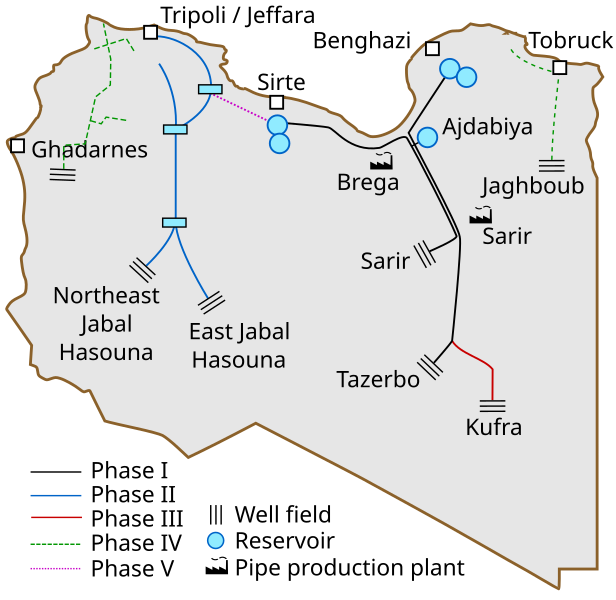
In September 1993, Phase I water from eastern well-fields at Sarir and Tazerbo reached Benghazi. Three years later, Phase II, bringing water to Tripoli from western well-fields at Jebel Hassouna, was completed.
Phase III which links the first two Phases is still under construction.

Adam Kuwairi, a senior figure in the Great Man-Made River Authority (GMRA), vividly remembers the impact the fresh water had on him and his family.

"The water changed lives. For the first time in our history, there was water in the tap for washing, shaving and showering," he told the BBC World Service's Discovery programme.

"The quality of life is better now, and it's impacting on the whole country."

To get an idea of the scale of the Great Man-Made River Project, you have to visit some of the sites.

Libya is opening up, but it's still hard for foreign journalists to get visas. We had to wait almost six months for ours; but once we arrived in Libya, Libyans were eager to tell us about the project.

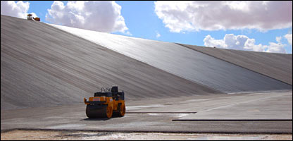
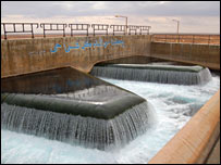
They took us to see a reservoir under construction at Suluq. When it's finished, the Grand Omar Mukhtar will be Libya's largest man-made reservoir.

Standing on the floor of such a huge, empty space is an awesome experience. Concrete walls rise steeply to the sky; tarring machines descend on wires to lay a waterproof coating over the concrete.

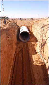
Further west along the coast is the Pre-Stressed Concrete Cylinder Pipe factory at Brega. This is where they make the 4m-diameter pipes that transport water from the desert to the coast.

It's a modern, well-equipped factory, built specially for the Great Man-Made River Project. So far, the factory has made more than half a million pipes.

The pipes are designed to last 50 years, and each pipe has a unique identification mark, so if anything goes wrong, engineers can quickly establish when the pipe was made.

The engineer in charge of the Brega pipe factory is Ali Ibrahim. He is proud that Libyans are now running the factory: "At first, we had to rely on foreign-owned companies to do the work.

"But now it's government policy to involve Libyans in the project. Libyans are gaining experience and know-how, and now more than 70% of the manufacturing is done by Libyans. With time, we hope we can decrease the foreign percentage from 30% to 10%."

Opening markets

With fossil water available in most of Libya's coastal cities, the government is now beginning to use its water for agriculture.

Over the country as a whole, 130,000 hectares of land will be irrigated for new farms. Some land will be given to small farmers who will grow produce for the domestic market. Large farms, run at first with foreign help, will concentrate on the crops that Libya currently has to import: wheat, oats, corn and barley.

Libya also hopes to make inroads into European and Middle-Eastern markets. An organic grape farm has been set up near Benghazi. Because the soil is so fertile, agronomists hope to grow two cereal crops a year.

It is hard to fault the Libyans on their commitment. They estimate that when the Great Man-Made River is completed, they will have spent almost $20bn. So far, that money has bought 5,000km of pipeline that can transport 6.5 million cubic metres of water a day from over 1,000 desert wells.
As a result, Libya is now a world leader in hydrological engineering, and it wants to export its expertise to other African and Middle-Eastern countries facing the same problems with their water.


Through its agriculture, Libya hopes to gain a foothold in Europe's consumer market.

But the Great Man-Made River Project is much more than an extraordinary piece of engineering.

Adam Kuwairi argues that the success of the Great Man-Made River Project has increased Libya's standing in the world: "It's another addition to our independence; it gives us the confidence to survive."

Of course, there are questions. No-one is sure how long the water will last. And until the farms are working, it's impossible to say whether they will be able to deliver the quantity and quality of produce for which the planners are hoping.

But the combination of water and oil has given Libya a sound economic platform. Ideally placed as the "Gateway to Africa", Libya is in a good position to play an increasingly influential role in the global economy.

BBC NEWS | Science/Nature | Libya's thirst for 'fossil water'
 
Thanks to Russia for Mi-17s, it has worked as a work horse many times for relief operations not just counter operations.
 
Thanks to Russia for Mi-17s, it has worked as a work horse many times for relief operations not just counter operations.
I can't forget 2005 earthquake & Chinook helicopters. We should ask help from U.S.A again..

20051115adf8239682_0147.jpg


100805-pakistan-aid-7a.grid-6x2.jpg
 
Last edited:

Back
Top Bottom