What's new

Ancient Pakistan

ghazi52

PDF THINK TANK: ANALYST
Joined
Mar 21, 2007
Messages
101,794
Reaction score
106
Country
Pakistan
Location
United States
Ancient Pakistan ....
. . . . . .
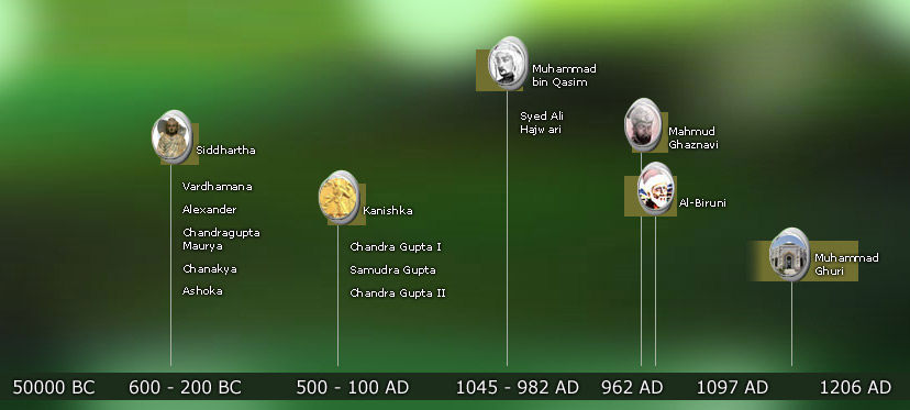
Whether or not the recent new pushing back ancient Chinese civilisation thousands of years is true or not http://www.newhistorian.com/chinese-...-thought/2638/, it is likely that the origins of all ancient civilisations will be pushed back in the years to come. We know very little about possible antecedent cultures, whether in Pakistan, Iraq or northern China. Even the Indus chronology itself is only slowly coming together.

10945050_855849661141686_2017383531502999274_n.jpg

....
.
Major Sites and Interaction Networks of the Indus Tradition, Harappan Phase, 2600-1900 BCE.

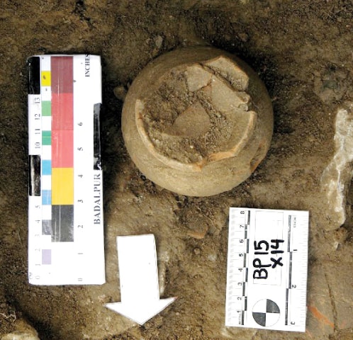
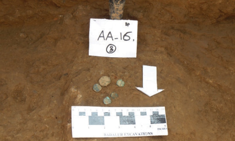
The Indus Valley had an extensive trading relationships with its neighbours and may have traded as far as Mesopotamia. Over the past century, several large Indus cities have been discovered in Pakistan. Harappa was excavated extensively in the 1920-30s, 1960s, and from 1986-2010. Mohenjo-Daro was excavated extensively in the 1920-30s, with smaller projects in the 1940s and 1960s. Ganweriwala was discovered in the 1970s and has not been excavated. Lakhanjo-Daro was discovered in 1986 but only recent excavations in 2009-2014 have shown that it is probably as big as Mohenjo-Daro.

1508156_807111656015487_5407273844988968037_n.jpg

.
.
Mohenjo-daro has been called the "city of wells." Mark Kenoyer writes: "On the basis of the number of wells found in the excavated areas, Michael Jansen has calculated that the city may have had over 700 wells. In contrast Harappa may have had as few as 30, since only 8 wells have been discovered in the areas excavated so far. The difference between these two cities may be that Mohenjo-daro had less winter rain and may have been situated far away from the Indus river. At Harappa a large depression in the center of the city may represent a large tank or reservoir accessible to the inhabitants from all the different neighborhoods. The site of Dholavira has only a few wells, but most water for the city was collected during the rainy season in large stone cisterns. The drains for collecting rain water were built separately from drains used to take away dirty sewage water." (Kenoyer, Ancient Cities, p. 59)

11165232_10153316472769846_3668669523758165886_n.jpg

Private Well, DK-G Area. Each block of buildings at Mohenjo-Daro was supplied with one or more wells such as this one in DK-G Area. When archaeologists excavated the fill around the well they were left standing to show the final levels of use.

11150528_10153316472794846_3879526500491193578_n.jpg

Well and platform, DK-G Area. This well was associated with a finely constructed bathing platform. A stairway leads up to the well and platform from a lower room. The walls and well have been covered with mud brick and sprayed with clay slurry to protect them from salt crystallization.
 
.......................
. . . .
A fascinating new paper examines human tooth enamel from burials at Harappa suggests that children migrated from resource rich hinterlands to urban centers during the Indus civilization. Evidence for Patterns of Selective Urban Migration in the Greater Indus Valley (2600-1900 BC): A Lead and Strontium Isotope Mortuary Analysis by Valentine B, Kamenov GD, Kenoyer JM, Shinde V, Mushrif-Tripathy V, et. al is another example of the use of complex investigative tools and materials analysis to decode patterns of behavior thousands of years ago; we can only expect more surprises as these tools are deployed against Indus artifacts.

11262284_914360958623889_2263658988302268366_n.jpg
 
...........
. . . .Mohenjodaro's New Story by Andrew Lawler in Archaeology remains an excellent summary of the unanswered questions and new directions for research on the city - it could have been far larger and not as planned as we think, the Buddhist stupa may not be as Buddhist as usually surmised, and the role of raw materials from as far away as Gujarat could have played a critical role in the city's development. In short, the latest theories and debates about Mohenjodaro and what happened later at http://andrewlawler.com/website/wp-c...henjo-Daro.pdf

10557267_780772811982705_6808275277950226920_n.jpg

..
.
Thor Heyerdahl (in his book "The Tigris Expedition") already discovered that below Mohenjo Daro's Buddhist stupa was a stepped pyramid-like structure, much like the Mesopotamian ziggurats.

Interestingly, Imhotep, one of Egypt's first architects (he was pharaoh Djoser's vizier, also a reed-boat builder, a hieroglyph developer and a physician) constructed the first stepped pyramid (the Djoser stepped pyramid) but in phases.

He started with a temple like bottom base made from baked brick, that may have been meant for fire/sun rituals (fire-altars Skt. 'peru' - 'fire'). This base was later expanded and 'built on top of' with the next stepped levels.

There are reasons to believe that there was a great influx of Indus ideas into Egypt brought about by Indus Valley migrants who entered into Egypt via a number of wadis from the Red Sea and from the Nile delta.

10547001_10152642608814846_2186621599830775919_o.jpg

.......................
.The Mounds of Harappa by Indus Period. The earliest settlement, during Period 1 (c. 3300-2800 BC), was on the west side of Mound AB and NW corner of Mound E. During Period 2 (c. 2800-2600 BC) all of Mounds AB and E came to be occupied, and by the end of Period 3 (c. 2600-1900 BC), the Harappan Period, most of the area covered by the plan was in use. During Periods 4 and 5 (c. 1900-1300 BC) there was a retraction of settlement to the areas of Mound AB, modern Harappa Town, and the NW corner of Mound E. This plan also shows the location of the 2000/2001 excavation areas

10551063_10152626402774846_8461773168027161919_n.jpg

........
..
Seals from Mohenjo-daro showing figure strangling two tigers with bare hands. Mark Kenoyer writes that "discoveries of this motif on seals from Mohenjo-daro definitely show a male figure and most scholars have assumed some connection with the carved seals from Mesopotamia that illustrate episodes from the famous Gilgamesh epic. The Mesopotamian motifs show lions being strangled by a hero, whereas the Indus narratives render tigers being strangled by a figure, sometime clearly males, sometimes ambiguous or possibly female. This motif of a hero or heroine grappling with two wild animals could have been created independently for similar events that may have occurred in Mesopotamia as well as the Indus valley," (Ancient Cities, p. 114). In color is a seal, in black and white two seals and corresponding sealings made from them (Joshi/Parpola, Corpus of Indus seals and inscriptions, Vol. 1, M 306-8).

10551011_10152605222259846_1651703211165055797_n.jpg


..............
. . . . Excavated by the Harappa Archaeological Research Project in 1993, this large corbeled drain was built in the middle of an abandoned gateway at Harappa to dispose of rainwater and sewage.

10418360_10152509907854846_2961876012796568902_n.jpg

.
Narrow streets and lanes, DK-G Area, Mohenjo-daro. Buildings and streets were aligned along a north-south and east-west grid with minor variations introduced as new buildings were constructed. The corbeled arch in the background was built to cover a street drain, but was eventually blocked as the cross streets were filled with debris.

10264710_10152387558384846_1351639608703685971_n.jpg

...
.Great Bath, looking north. The tank would have been open to the sky, but the surrounding structures would have been roofed. The sidewalls and parts of the floor have been conserved using modern replica bricks. The original eroded wall and corner are visible on the left and center. The colonnades around the tank have also been reconstructed.

1493254_10152329802039846_630703200_n.jpg

....
.
 
Third century BC stupa discovered at ancient Buddhist site

AMJAD IQBAL

554d2a488b175.jpg


Excavations being carried out at the newly discovered stupa at Badalpur near Taxila. The other pictures are of the discoveries unearthed. — Dawn

TAXILA: A stupa dating back to the 3rd Century BC was discovered at the ancient Buddhist site of Badalpur near Taxila during excavations carried out by the Taxila Institute of Asian Civilisations (TIAC) of Quaid-i-Azam University.

The stupa measuring 25x25 was discovered on the southern side of the main monastery with a centre water tank at the ancient Buddhist site. Coins, pottery and metal objects have also been excavated from the site by graduate and doctorate students of the TIAC. The students were led by the institute’s director, Professor Dr Ashraf Khan, Assistant Professor Dr Sadid Arif and Coordinator Mohammad Ibrahim.

Professor Dr Ashraf Khan told Dawn that the newly discovered monastery was built in Kushan workmanship style known as ‘diaper masonry’, consisting of thin neatly placed layers of schist interspersed with large blocks of stone as well as semi-ashlar masonry.

554d2a8f5dae7.jpg

He said the cells of the monastery are plastered with mud mortar, the first of its kind seen in the Taxila Valley.

In response to a query, Dr Khan said the discovery of metal objects showed the craftsmanship of the people living in the area between the first and fourth century.

Dr Khan said six copper coins from the Kushan period have been discovered in the excavations. He said that according to the carbon study of the newly discovered stupa carried out by the University of Wisconsin-Madison dates it between the 3rd century BC to 1st century AD.

He said during the last season of the excavation, a good number of antiquities such as a bust of Buddha in stucco, copper coins, bones, charcoal, iron objects and pottery were discovered.

554d2b0fc7644.jpg

Unveiling the archaeological significance of the site, he said the site was early mentioned by Alexander Cunningham in 1863, the then director, Archaeological Survey of India, during his expedition to Gandhara.

The first excavation at the site was carried out in 1916-17 by Natisa Aiyar, superintendent of Frontier Circle, while the second was carried out from 2005 till 2009 by Federal Archaeology in collaboration with Taxila Institute of Asian Civilisations, Quaid-i-Azam University.

He said five seasons of excavations had been successfully conducted by the institute at this ancient Buddhist site.

The most remarkable discovery was an iron nail and animal bones which revealed that Gandhara people knew the use of different metals and that Buddhists used to eat meat, said Dr Khan.
 
...........................
.
.Rare discoveries made at Bhamula Stupa site
By Amjad Iqbal
Rare discoveries made at Bhamula Stupa site - Pakistan - DAWN.COM

54f7817829799.jpg


TAXILA: Archaeologists have discovered the largest statue ever found in Gandhara depicting the death of Buddha as well as a ‘double-halo’ Buddha statue, the first of its kind to have been found at the Bhamala Stupa site.

The rare discovery was made during excavations at the Buddhist stupa and monastery dating back to 4th century AD.

Dr Abdul Samad, Khyber Pakhtunkhwa director, Department of Archaeology and Museums, told Dawn that the latest discoveries by the archaeologists have opened new chapters in the history of the ancient Taxila valley civilisation.

“This is one of the few sites in the world to have the cruciform Stupa which was reserved for Buddha himself.”

Discussing details of the new discoveries, he explained that the death of the Buddha scene is known as ‘Maha Pari Nirvana’. The statue depicting the scene, measures 14 metres in length, and is the largest ever statue of its kind found in the archaeological history of Gandhara civilisation. The image is placed on a 15 metre long platform.

Dr Samad said Buddha’s head is missing as the site appears to have been targeted by illegal treasure hunters.

“Other parts of the statue such as the left leg and arms were also found in a damaged condition,” he said.

He said other images in terracotta have been found near the Par Nirvana scene. He added that Pari Nirvana scene was exposed from a long chamber to the west of the main Stupa facing towards east. He added that access to this chamber is given through three openings at regular intervals. The chamber is made of stone in semi ashlars masonry.

He explained that the statue of Buddha with double halos was unique and such a statue had never been found at this site.

In the past statues, heads of Buddha statues and coins from the Kushan period had been found at the site.

“In the first leg of this excavation, archaeologists have opened a new chapter in the archaeological history of the Taxila valley. Through the recent discoveries, it has been confirmed that the site dates back to 3rd century CE. Recently discovered Buddha heads are made in baked soil which dates to the third century, rejecting archaeologist John Marshal’s claim from 1930 that the site was from 12th century CE.”

Dr Samad said during this leg of excavations, other relics such as a carnelian seal depicting what appears to be the Gaja Lakshmi deity, one of the forms of Hindu goddess Ashta Lakshmi have been discovered.

54f781c0f35fb.jpg


Other relics with Kashmiri influence have added new dimensions to what we know about these ancient civilisations.

“Several terracotta and stucco Buddha statues and copper coins were discovered at this site which date back to the Kidara-Kushan period (4 to 5 CE). This indicates that Bhamala was not isolated from main Taxila,” he said.

He said the material found in Bhamala could improve our understanding of Buddhist culture, development and contact in this region.

“The success of the Bhamala Stupa study would also encourage other archaeologists to come to Pakistan,” he said.

Dr Samad elaborated upon the importance of this site. He said the Bhamala complex was different from other sites in Taxila valley.

“The stupa, shaped like a cross, resembles Aztec Pyramids and such constructions had only been found in Kashmir, in the past. He said the main stupa was cruciform and there were about 19 small votive stupas in the courtyard surrounding the main stupa.

He further revealed that during the recent excavation, a total of 510 relics were discovered, which included terracotta, stucco sculptures as well as iron objects including nails, hooks, door fittings, hair clips, copper artifacts and 14 coins from the late Kushan period.

He said that samples of organic materials were also taken for radio carbon dating by Professor Dr Mark Kenoyer, Director of the Centre for South Asia and Professor of Anthropology at the University of Wisconsin Madison in the US.
 
Last edited:
................................

.A Brief History of Pakistan By James Wynbrandt

https://ia801704.us.archive.org/30/i...f-Pakistan.pdf


THE LAND AND ITS EARLY HISTORY

Few nations have as rich or complex a history as the Islamic Republic of Pakistan. Its destiny has been shaped fi rst by its geography. The violent collision of continents that formed this land threw up great mountains that made this cornerof the subcontinent a place apart. The sequestered, fertile environment of the Indus Valley nurtured one of the world’s fi rst great civilizations. Yet the passes that breached the guarding massifs served as funnels through which invaders both hostile and friendly have poured for millennia. These outsiders have been the second great ingredient in Pakistan’s destiny. They brought their traditions, ideas, and ways of life, all of which have become part of the nation’sidentity. This chapter surveys the nation’s physical landscape, its fi rst civilizations, and the provinces that today refl ect the historical divisions that have made Pakistan’s past and present so vibrant, dynamic, and tumultuous. The chapter also introduces the Aryans, the fi rst of the interloping groups that would shape the history and heritage of what is today Pakistan. The Aryans’ experiences here would give rise to the Hindu religion, which continues to be a force with apowerful effect on the region today. Geology and Geography Before the continents as we know them came to be, the land that is now Pakistan and India were part of Gondwanaland, an ancient supercontinent.

Some 200 million years ago Gondwanaland began to break apart, torn by tectonic forces. Over time thesupercontinent’s remnants formed landmasses including Africa, South America, Antarctica, Australia, the Arabian Peninsula, and the Deccan Plateau, or the Indian subcontinent. At the time the Eurasian landmass was separated from the disintegrating supercontinent by a long, shallow sea.
streams and rivers that drained what we know now as Asia deposited sandy runoff into this basin while the calcifi ed remains of sea creatures likewise accreted. Over time these deposits became sandstone and limestone. After Gondwanaland splintered, the future Deccan Plateau moved north, toward Eurasia. As the two landmasses drove toward each other, the sandstone and limestone that had carpeted the sea fl oor between them was thrust upward. Atleast 45 million years ago the landmasses met. The submarine deposits ultimately became the fold mountains that now form a ridge across southern Asia from the Mediterranean to the Pacifi c. The contorted, visible bowing of the sedimentary rocks from which the mountains formed bears evidence of the compression caused by the slow tectonic collision. The peaks reach their highest point at the north end of the subcontinent. These are the Himalayan Mountains.Marine fossils found on Mount Everest, the world’s highest peak, attest to its undersea ancestry. The Himalayas and its offshoots, which fl ank southward on the east and west sides of the subcontinent, have served as a natural barrier to both the elements and humanity, separating the lands that became Pakistan and India from the rest of Asia. By 11 million B.C.E. migration of animals from and to the subcontinent had ended.

.............................................
.Topography

To its south, west, north, and northeast, natural barriers of mountain and sea have sheltered Pakistan. But to the southeast, the land spills out into the Deccan, the vast peninsular homeland of India. The Indus River, historically the lifeblood of what would become Pakistan, and its tributaries drain the plateau. Though its terrain is varied throughout the country, Pakistan can be divided into three basic geographic areas: the northern highlands, the Baluchistan Plateau, and the Indus River plain. These areas can be further segmented into the Salt Mountains and the Potwar Plateau, north of the Indus Plain; the Western Mountain region (composed of the mountains in western Baluchistan); and the Upper and Lower Indus River Plain (roughly corresponding with the presentday provinces of Punjab and Sind, respectively). The Arabian Sea forms Pakistan’s southern border. Its western border is shared with Iran in the south and Afghanistan in the north. Along Pakistan’s northern border the slim arm of Afghanistan’s Wakhan region separates Pakistan from Tajikistan. China’s territories of Xinjiang and Tibet lie on Kashmir’s border to the north and east. To Pakistan’s east are the Indian states of Punjab and Rajasthan. The Thar Desert serves as a barrier between these Indian lands and Pakistan. Despite the absence of any other barriers between these two states, historically they developed independently.
.
THE INDUS RIVER

The Indus River is Pakistan’s principal waterway. Known as the Sindhu in Sanskrit, the Sinthos in Greek, and the Sindus in Latin, it has been integral to Pakistan’s culture and history, yet paradoxically gave its name to India, Pakistan’s neighbor and rival. Its headwaters are in the Himalayas in Tibet. It fl ows northwest through Gilgit-Baltistan in Kashmir before turning south and traversing the length of Pakistan, its total length between 1,800 and 2,000 miles (2,900–3,200 km). The river gave birth to one of the world’s fi rst great civilizations, the Indus Valley Civilization. The course of the river has changed since ancient times as a result, it is believed, of earthquakes and other shifts of the land. Today it is damned at Tarbela, at the foothills of the Himalayas between Peshawar and Rawalpindi. Shortly after Pakistan became independent in 1947, India, which was given the region with the river’s headwaters by the British, shut the fl ow of water to the Indus, creating a grave crisis that took more than 15 years to resolve. The Indus River, Pakistan’s principal waterway, has played an integral role in the region’s history and culture. (Courtesy Pakistan Tourism Development Corporation).

The Himalayas

The Himalayas (meaning “the abode of snow” in Sanskrit) extend in a long bow some 1,500 miles (2,400 km) across the north end of the subcontinent, from the Indus River in the west to the Brahmaputra River (which originates in Tibet and ends in the Bay of Bengal) in the east. Four major ranges comprise the Himalayas: The Outermost, or Sub-Himalayas, are the farthest south. Its low hills, known as the Siwaliks, rise to about 3,000 feet (914 m). To the north lie the Outer, or Lesser Himalayas, whose peaks average 14,000–15,000 feet (4,267–4,572 m). Behind the Pir Panjal Range of the Outer Himalayas rise the Central, or Great Snowy Himalayas. In the Karakoram Range, permanently snow-covered peaks average 20,000 feet (6,096 m) in height and include Mount Everest, the world’s loftiest peak (29,028 feet; 8,848 m), and in Pakistan-controlled 001-311_BH-Pakistan_ch.indd 4 10/28/08 11:45:02 AM Free Pdf Books The Land and Its Early History Kashmir, K2, the world’s second highest peak (28,251 feet; 8,611 m). North of Pakistan’s border is the Ladakh Range, or Inner Himalayas. In Pakistan’s northwest is the Hindu Kush (Hindu Killer) Range, extending from the high plateau of Pamir, sometimes called the Roof of the World, into Afghanistan. Tirich Mir is its highest peak (25,289 ft.; 7,708 m). The Himalayas have had important historical and climatological effects on Pakistan and the entire subcontinent. They capture moisture-laden winds from the Arabian Sea (and to the east, the Bay of Bengal) and create rain that irrigates the region. In winter they block cold winds from North and Central Asia, keeping the subcontinent’s climate mild. Spring melt-offs provide water. Historically the Himalayas and contiguous ranges have also formed a barrier protecting the region from the incursions of outsiders. Several passes along Pakistan’s western and northern borders provide routes in and out of the nation and have been key transit points throughout recorded history. Western Mountains In Baluchistan, west of the Indus Plain, three minor ranges run parallel south from the Hindu Kush to the Kabul River, their valleys draining the Swat, the Panjikora, and the Chitral-Kunar Rivers.

K2, the world’s second highest peak (28,251 feet; 8,611 m). North of Pakistan’s border is the Ladakh Range, or Inner Himalayas. In Pakistan’s northwest is the Hindu Kush (Hindu Killer) Range, extending from the high plateau of Pamir, sometimes called the Roof of the World, into Afghanistan. Tirich Mir is its highest peak (25,289 ft.; 7,708 m). The Himalayas have had important historical and climatological effects on Pakistan and the entire subcontinent. They capture moisture-laden winds from the Arabian Sea (and to the east, the Bay of Bengal) and create rain that irrigates the region. In winter they block cold winds from North and Central Asia, keeping the subcontinent’s climate mild. Spring melt-offs provide water. Historically the Himalayas and contiguous ranges have also formed a barrier protecting the region from the incursions of outsiders. Several passes along Pakistan’s western and northern borders provide routes in and out of the nation and have been key transit points throughout recorded history. Western Mountains In Baluchistan, west of the Indus Plain, three minor ranges run parallel south from the Hindu Kush to the Kabul River, their valleys draining the Swat, the Panjikora, and the Chitral-Kunar Rivers. K2, the world’s second-highest peak, is in Pakistan-controlled Kashmir. (Courtesy Pakistan Tourism Development Corporation) Free Pdf Books A BRIEF HISTORY OF PAKISTAN 6 The Safed Koh Range, which runs east–west, has peaks averaging about 12,000 feet (3,657 m). The Khyber Pass, the most famous of the high-elevation gateways to the subcontinent, cuts through its mountains. About 33 miles (53 km) in length, the pass extends from Jamrud, some 10 miles (16 km) from Peshawar, Pakistan, to Dakka in Afghanistan. South of the range is the Kurram River. The Kurram Pass, which goes through Parachinar, Thal, and Kohat, has long been another favored route to Afghanistan. To the south, the Waziristan Hills lie between the Kurram and Gomal Rivers. The Gomal Pass, named for the Gomal River, which feeds into the Indus, has been an important trade route between Afghanistan and Pakistan for nomadic tribes known as the Powindahs. (Today their entry into Pakistan is restricted.)
 
Thanks. I will do my best................................:smitten:
 
It is infact now proven that we Pakistanis are the true ancestors of majority of the indians.

Not really. Only the ANI part of their genes come from Pakistan and Central Asia. The highly ASI Indians far outnumber the relatively more ANI Indians.
 
......1526 - 1857..... . . . . .
. .
.
1526 – 1857
The Mughal Empire
1526-1857Events.jpg


.............................
 

Back
Top Bottom