Ah the first is a difficult question, so I'll tackle the second first.
Yup, Northern side is in China with 2 established routes; North Ridge and the North-West Face (Not to be confused with the North-West Ridge). The Chinese side of the mountain is the less frequently visited side, and there are usually no climbers on this side of the mountain. Even though it's less technical to get to the northern base camp, its more difficult in the sense that its not very organized; you have to manage everything by yourself. The Pakistani side is more popular because 1) Most of the mountain is in Pakistan, 2) Except 2, all the routes are completely on the Pakistani side, 3) The easiest route is on the Pakistani side, 4) the most climbed route is on the Pakistani side, 5) the trek to get to the Pakistani side is a lot more organized; porters, midway camps, etc., etc. And yes, I've heard that you have to cross Shaksgam to get to the Chinese side. But the lesser frequency also has it's own allure
")
The North Ridge and the North-West Ridge:
(The North Ridge is the route that Gerlinde Kaltenbrunner climbed up, making her the first woman to climb all the eight-thousanders without oxygen)
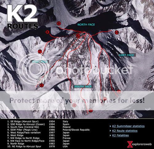
Ok, now for the most difficult. Well, it kinda depends on whom you ask about it. The most easy is the Cesen and the most frequently taken is the Abruzzi (But I'm sure you know that these are still one of the most difficult routes in the world. Goes to show the character of K2). The South Face, the South-South-West Pillar (or the so called Magic Line) and the North-West Ridge are all said to be the hardest. The "Magic Line" is the one that Reinhold Messner went to attempt, looked at, called it the suicide route, abandoned it and went up the Abruzzi. This is also the route most widely considered to be the most difficult followed by the South Face.
Abruzzi Spur-> 178 summits and 52 deaths. Fatality rate: 29.2%
Cesen -> 55 summits and 10 deaths. Fatality rate: 18.2
North Ridge (Chinese) -> 28 summits and 6 deaths. Fatality rate: 21.4%
Magic Line -> 4 summits and 6 deaths. Fatality rate: 150%
South Face -> 2 summits and 1 death. Fatality rate: 50%
North-West Face -> 2 summits and 0 deaths. Fatality rate: 0%
North-West Ridge -> 2 summits and 0 deaths. Fatality rate: 0%
Interestingly two routes are still un-climbed:
East Face-> 0 summits and 1 death. Fatality rate: 100%
North Face (North-East)-> 0 summits and 0 deaths.
(Note: These stats, sadly, don't show the failed attempts and they are only till the 2008 climbing season. But the stats for the most difficult faces have remained unchanged to my knowledge)
All the routes:
I have a book with some route details, has a good poster in it. I'll try to find it's pdf and upload that poster.


")