黄岩岛 Huangyan Dao (scarborough shoal) does not belong to the Phillipines:
"According to Treaty of Paris(1898) between the United States and Spain, Treaty of Washington(1900) between Spain and the United States, Treaty between Great Britain and the United States(1930), Constitution of the Philippines (1935), Republic Act No. 3046 "Act to Define the Baselines of the Territorial Sea of the Philippines"(1961), and all the maps published by Philippines official until 1990s, 118th degree meridian of longitude east of Greenwich is the territorial limit line of Philippines. Scarborough Shoal is obvious outside this limits, and Philippines has never made claim or put dispute on Scarborough Shoal, which is internationally recognized as teritory of China. But in the following years, Philippines made an unilateral decision to include Scarborough Shoal as its territory, ignoring China's opposition.
Most Philippines maps published by Spain and United States in 18th and 19th century does not show Scarborough Shoal or show it as foreign territory, for example, in the same color as Malaysia and China."
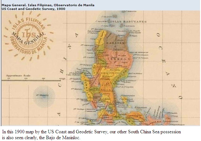
Mapa General Islas Filipinas Observatorio de Manila
US Coast and Geodetic Survey, 1900
The basis of Philippine sovereignty and jurisdiction over the rock features of Bajo de Masinloc is not premised on the cession by Spain of the Philippine archipelago to the United States under the Treaty of Paris. The matter that the rock features of Bajo de Masinloc are not included or within the limits of the Treaty of Paris as alleged by China is therefore immaterial and of no consequence.
Philippine sovereignty and jurisdiction over the rocks of Bajo de Masinloc is likewise not premised on proximity or the fact that the rocks are within its 200-NM EEZ or CS under the UN Convention on the Law of the Sea (UNCLOS). Although the Philippines necessarily exercise sovereign rights over its EEZ and CS, nonetheless, the reason why the rock features of Bajo de Masinloc are Philippine territories is anchored on other principles of public international law.
As decided in a number of cases by international courts or tribunals, most notably the Palmas Island Case, a modality for acquiring territorial ownership over a piece of real estate is effective exercise of jurisdiction. Indeed, in that particular case, sovereignty over the Palmas Island was adjudged in favor of the Netherlands on the basis of effective exercise of jurisdiction, although the said island may have been historically discovered by Spain and historically ceded to the U.S. in the Treaty of Paris.
In the case of Bajo de Masinloc, the Philippines has exercised both effective occupation and effective jurisdiction over Bajo de Masinloc since its independence.
The name Bajo de Masinloc (translated as under Masinloc) itself identifies the shoal as a particular political subdivision of the Philippine province of Zambales, known as Masinloc.
One of the earliest known and most accurate maps of the area, named Carta Hydrographical y Chorographica De Las Yslas Filipinas by Fr. Pedro Murillo Velarde, SJ, and published in 1734, included Bajo de Masinloc as part of Zambales.
The name Bajo de Masinloc was a name given to the shoal by the Spanish colonizers. In 1792, another map drawn by the Alejandro Malaspina expedition and published in 1808 in Madrid, Spain, also showed Bajo de Masinloc as part of Philippine territory. This map showed the route of the Malaspina expedition to and around the shoal. It was reproduced in the Atlas of the 1939 Philippine Census.
The Mapa General, Islas Filipinas, Observatorio de Manila, published in 1990 by the U.S. Coast and Geodetic Survey, also included Bajo de Masinloc as part of the Philippines.
Philippine flags have been erected on some of the islets of the shoal, including a flag raised on an 8.3-meter high flagpole in 1965 and another Philippine flag raised by Congressmen Roque Ablan and Jose Yap in 1997. In 1965, the Philippines also built and operated a small lighthouse in one of the islets in the shoal. In 1992, the Philippine Navy rehabilitated the lighthouse and reported it to the International Maritime Organization for publication in the List of Lights (currently, this lighthouse is not operational).
Bajo de Masinloc was also used as an impact range by Philippine and U.S. Naval Forces stationed in Subic Bay in Zambales for defense purposes. The Philippines Department of Environment and Natural Resources, together with the University of the Philippines, has also been conducting scientific, topographic, and marine studies in the shoal. Filipino fishermen have always considered it as their fishing grounds, owing to their proximity to the coastal towns and areas of Southwest Luzon.
In 2009, when the Philippines passed an amended Archipelagic Baselines Law that is fully consistent with the Law of the Sea, Bajo de Masinlocs was classified under the Regime of Islands consistent with the Law of the Sea.
Section 2. The baseline in the following areas over which the Philippines likewise exercises sovereignty and jurisdiction shall be determined as Regime of Islands under the Republic of the Philippines consistent with Article 121 of the United Nations Convention on the Law of the Sea (UNCLOS):
a) The Kalayaan Island Group as constituted under Presidential Decree No. 1596; and
b) Bajo de Masinloc, also known as Scarborough Shoal.
-A Filipino maritime law expert has dug up a 1916 Philippine Supreme Court decision which shows Manila not China has had actual legal and maritime jurisdiction over Scarborough Shoal for at least a century.
In contrast, China imposed its legal jurisdiction over Scarborough Shoal only this week by creating a law-making body to enact laws over Sansha City, which now includes Scarborough Shoal or Huangyan Island. China started imposing its maritime jurisdiction over Huangyan this year when it asserted the rights of its fishermen to fish in and around Huangyan.
-Scarborough Shoal entered Philippine jurisprudence in 1916 when the Philippine Supreme Court decided a case involving a shipwreck there. The shipwreck predates Chinas 1935 claim.
-the lawsuit decided by the Philippines top court in 1916 led by Filipino Chief Justice Cayetano Arellano is clear evidence that we were exercising jurisdiction over the shoal and incidents on it during the American colonial period in the Philippines.
This case is proof we are the ones responsible when it comes to shipwrecks on Scarborough,
-And the fact that a lawsuit involving a foreign vessel was brought before and decided by a Philippine court led by a Philippine judge shows that foreigners recognized that the Philippines had legal jurisdiction over incidents on Scarborough Shoal for nearly a century.
Isnt this argument for claiming Philippine jurisdiction far stronger than making Scarborough Shoal a reference point for a survey map of the South China Sea drawn in 1279
-the United States amended the 1898 Treaty of Paris with Spain by negotiating and signing the 1900 Treaty of Washington in order to buy up the outlying islands of the Philippines which were not expressly included in the Treaty of Paris. Outlying Islands mean outside the area delineated by the Treaty of Paris in 1898. Scarborough Shoal was one of those outlying islands. Bajo de Masinloc is considered as having been ceded to the United States by Spain through the Treaty of Washington in the 1900.
Heres the link to the actual SC decision that shows the Philippines jurisdictional claim on Scarborough over that of China:
G.R. No. L-10051
-China has to this day not produced for public scrutiny the 1279 map on which it bases it historical claim.
-The Treaty of Washington has only one section and it says:
Spain relinquishes to the United States all title and claim of title; which she may have had at the time of the conclusion of the Treaty of Peace of Paris, to any and all islands belonging to the Philippine Archipelago, lying outside the lines described in Article III of that Treaty and particularly to the islands of Cagayan Sulu and Sibutu and their dependencies, and agrees that all such islands shall be comprehended in the cession of the Archipelago as fully as if they had been expressly included within those lines. [Underlining mine.]
For this, the US paid Spain an additional US$100,000.
-Bajo de Masinloc (the name given to Scarborough Shoal by Spanish and European maps) is in the first official American map of the Philippine Islands issued in 1900 by the US Bureau of Coast and Geodetic Surveys.
-At that time of the signing (of the Treaty of Washington), Bajo de Masinloc was always under the direct control of the the Philippine (colonial) government primarily for purposes of safety of navigation.