ghazi52
PDF THINK TANK: ANALYST

- Joined
- Mar 21, 2007
- Messages
- 101,790
- Reaction score
- 106
- Country

- Location

......Nathia Gali............... .. . . . .
.. . .
. .
Nathia Gali, located at 2,500 m (8,200 ft) height from the sea level,is a hill station in Hazara Division, Khyber Pakhtunkhwa Province. It is at two hours drive away from Islamabad. It is famous for its scenic beauty, hiking tracks and pleasant weather. It is situated at one hour’s drive away from both Murree and Abbottabad, lying midway between these two places.
“Mukshpuri” and “Miranjani” are the two nearby high peaks both of which are favourite for hikers. The Mukshpuri track is wide and easy to hike. The Miranjani track, is a bit more difficult as it has steeper height and the track is narrow at some places. Both of these peaks could be reached within 2 to 3 hours by hiking.
Nathia Gali has been declared a wildlife sanctuary by the Government. Monkeys, leopards and variety of other birds and animals are common in the forest surrounding Nathia Gali. Monkeys foraging on trees is not an uncommon sight in Nathia Gali.
Governor House at Nathia Gali

Governor House Nathia Gali. Photo by Asif Saeed.

A View of Miranjani Peak from Nathia Gali. Miranjani track is a bit more difficult as it has steeper height and the track is narrow at some places. The Miranjani Peak could be reached within 2 to 3 hours by hiking.

Mukshpuri Peak Nathia Gali during Summer. Mukshpuri is a 9,200 feet high mountain in the Nathia Gali Hills where one can reach by trekking either from Nathiagali trek or Dunga Gali trek. It is just above Dunga Gali in the Nathiagali area of Ayubia National Park. The route from Nathia Gali on western side of mountain is a steady and 2.5 kilometers long climb and it will take about 2 hours. The route from the Dunga Gali side has a steeper slope. There is a bird sanctuary on this side created with the help of the European Union. From the top of Mukshpuri peak one can see Circle Bakote, Jhelum River, the Bagh District of AJK, in the south the city of Murree and the Murree Tehsil, as well as Islamabad.

Mukshpuri Peak Nathia Gali during Winter

Information Board, from Lalazar Wildlife Park to Mukshpuri Trek, Nathia Gali
 .
.
.
.
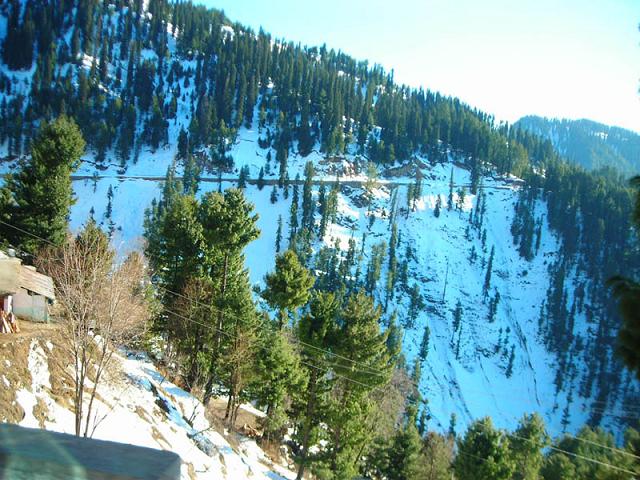
Enroute Nathia Gali.

.. . .
. .
Nathia Gali, located at 2,500 m (8,200 ft) height from the sea level,is a hill station in Hazara Division, Khyber Pakhtunkhwa Province. It is at two hours drive away from Islamabad. It is famous for its scenic beauty, hiking tracks and pleasant weather. It is situated at one hour’s drive away from both Murree and Abbottabad, lying midway between these two places.
“Mukshpuri” and “Miranjani” are the two nearby high peaks both of which are favourite for hikers. The Mukshpuri track is wide and easy to hike. The Miranjani track, is a bit more difficult as it has steeper height and the track is narrow at some places. Both of these peaks could be reached within 2 to 3 hours by hiking.
Nathia Gali has been declared a wildlife sanctuary by the Government. Monkeys, leopards and variety of other birds and animals are common in the forest surrounding Nathia Gali. Monkeys foraging on trees is not an uncommon sight in Nathia Gali.
Governor House at Nathia Gali

Governor House Nathia Gali. Photo by Asif Saeed.

A View of Miranjani Peak from Nathia Gali. Miranjani track is a bit more difficult as it has steeper height and the track is narrow at some places. The Miranjani Peak could be reached within 2 to 3 hours by hiking.

Mukshpuri Peak Nathia Gali during Summer. Mukshpuri is a 9,200 feet high mountain in the Nathia Gali Hills where one can reach by trekking either from Nathiagali trek or Dunga Gali trek. It is just above Dunga Gali in the Nathiagali area of Ayubia National Park. The route from Nathia Gali on western side of mountain is a steady and 2.5 kilometers long climb and it will take about 2 hours. The route from the Dunga Gali side has a steeper slope. There is a bird sanctuary on this side created with the help of the European Union. From the top of Mukshpuri peak one can see Circle Bakote, Jhelum River, the Bagh District of AJK, in the south the city of Murree and the Murree Tehsil, as well as Islamabad.

Mukshpuri Peak Nathia Gali during Winter

Information Board, from Lalazar Wildlife Park to Mukshpuri Trek, Nathia Gali
 .
..
.
Enroute Nathia Gali.


")