What's new

Murree Altitude

No, Clouds Really come in to house which are really high like 7000 ft -8000 ft In nathiagali and Murree, Clouds are just air filed with moisture and H2O Molecules!

and Mr SpongeBob then explaind it well...:what:

M_Id_94054_SpongeBob.jpg
 
.
and Mr SpongeBob then explaind it well...:what:

M_Id_94054_SpongeBob.jpg

Before laughing at me do some research or go study something instead of wasting you time here!

Clouds do come low in such places which are high as muree And in even higher places like chitral valley! Clouds are just baaf!

Duo-Lakes-1024x768.jpg


Look at this pic by @Windjammer

DSC00741.jpg
 
Last edited by a moderator:
.
Before laughing at me do some research or go study something instead of wasting you time here!

Clouds do come low in such places which are high as muree And in even higher places like chitral valley! Clouds are just baaf!

Duo-Lakes-1024x768.jpg


Look at this pic by @Windjammer

DSC00741.jpg

$(KGrHqR,!o4FB+mhG8wZBQf8Z-vRJ!~~60_35.JPG
 
Last edited by a moderator:
.
Sunehray Din, filmed in and around Abbotabad. Watch from 2.00 and see Gulsher running through the clouds. :D


Last edited by a moderator:
. .
The two pictures taken from the same spot give you an idea how clouds descend on Murree.

DSC00728.jpg

The white dome on the opposite hill has a helipad right next to it.

The telephone tower has tennis and basketball courts, and Offrs Mess right next to it.

The whole area is HQ 12 Div. APS schools and CMH is also located near it.

This was the hill I was referring to in my earlier post.

And the clouds story is as real as it gets. We had to put our clothes and stuff outside in the sun the next day because they got all moist.
 
.
The white dome on the opposite hill has a helipad right next to it.

The telephone tower has tennis and basketball courts, and Offrs Mess right next to it.

The whole area is HQ 12 Div. APS schools and CMH is also located near it.

What radar does that dome house? The YLC-2 or the TPS-77?
 
.
In pakistan highest peak mountain is above 28000 feet so murree is well below so no problem at all
 
.
What radar does that dome house? The YLC-2 or the TPS-77?

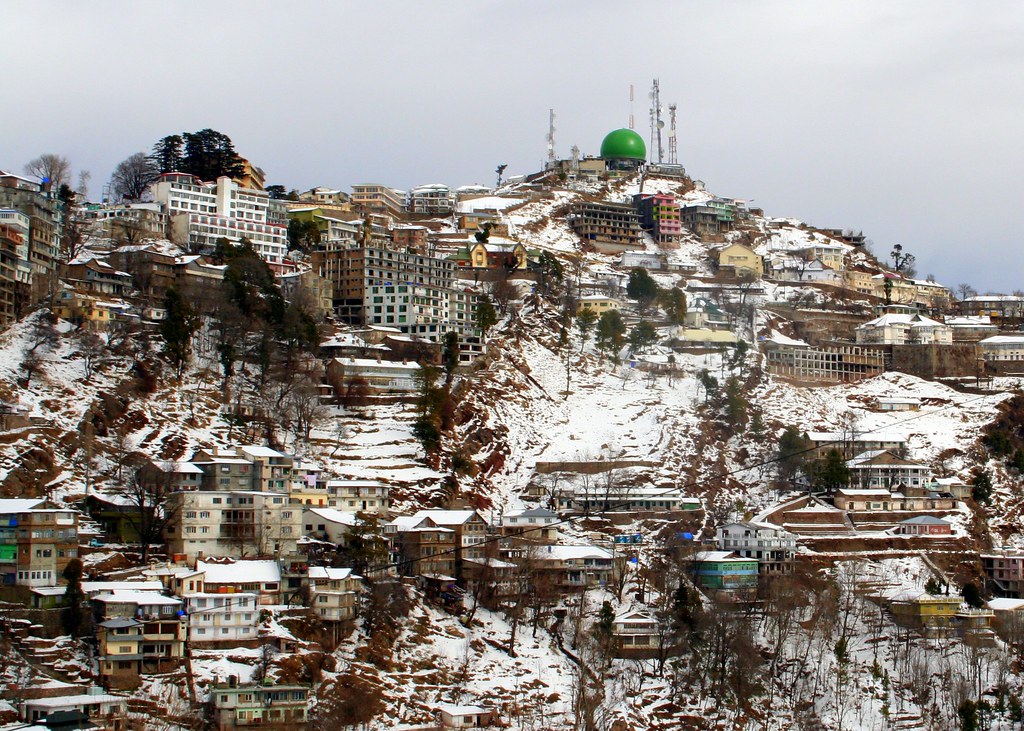
Nothing. It is a mosque if i remember correctly.

There is a green dome located behind the picture taker, near pindi point if i am not mistaken, but that is a weather radar.

The PAF radar is located at PAF base lower topa, some distance away, right on the exit of extended expressway.

I am on phone now, will try to find some pics tomorrow and put it all in perspective.
 
.
Well never heard of anyone facing this HA sickness in murree.
 
.
Murree is so beautiful. Hoping that we can get rid of terrorism so tourism can prosper.
 
.
Here is the dome.. @AhaseebA.

2188109061_5b38f781cc_b.jpg


The 13 Div HQ is to the left of this.

Murree is so beautiful. Hoping that we can get rid of terrorism so tourism can prosper.

Murree is beautiful and very much accessible but now slowly the whole area is land sliding. Construction of 10-12 floor buildings on pencil columns has meteorically risen, the whole area looks like a concrete jungle. One rain comes, and the whole area gets shifted.

Recently a parking plaza was being constructed near Jhika gali, the whole place had a land slide, and the road was washed away. A wooden bridge is now in place (last time I went there), and traffic from one side (a couple of cars) can pass through it. It is a major choke point.

IMO, proper regulation has to be done, and more greenery be preserved rather than erecting buildings all over the place.
 
Last edited by a moderator:
.

Pakistan Defence Latest Posts

Pakistan Affairs Latest Posts

Back
Top Bottom