What's new

Pakistan Remote Sensing Satellite System - PRSSS News & Update

My friends in SUPARCO tell me it was until recently supposed to be a mostly indigenous satellite, but now it is going to be along the lines of PAKSAT-1R. I am guessing SUPARCO was taking too long (and/or it was getting too expensive).
Your friends at SUPARCO were misinforming you.:-)

My friends in SUPARCO tell me it was until recently supposed to be a mostly indigenous satellite, but now it is going to be along the lines of PAKSAT-1R. I am guessing SUPARCO was taking too long (and/or it was getting too expensive).
Your friends at SUPARCO were misinforming you.:-)
Thanks for the info.

What percentage of Pak TES-1 is "indigenous"? Any insight? Also---when can we see a Pakistani SLV, if ever?
Senors were purchased, everything else is locally made (of course parts and comppnents are also purchased).
 
.
Shot Taken by Pakistani Made Satellite launched last week
Mashallah


DiPcpB0WsAAXEfl.jpg
 
. . .
We need at least
1 Comm satellite for secure military communication across all Pakistani military units
4 Recon satellites with 0.5 meter resolution or less for 24 hour coverage (2 for India, one each for Iran and Afghanistan)
4 LPS satellites for local positioning system for our precision weapons within a range of 10,000 nautical miles

Combined they would cost around 10/12 fully paid f-16, but the benefits would out weight a full squadron
I think we can rely on Chinese global positioning system and other important data ... The more critical item is satellite infrastruture required for MALE and HALE drones as they are the future of warfare ...
 
.
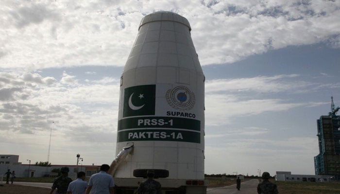
Pakistan's first-ever remote sensing satellite PRSS-1 becomes operational today


355128_9246483_updates.jpg


The first-ever Remote Sensing Satellite and Technology Evaluation Satellite of Pakistan have become operational from Tuesday.


Ministry of PD&R@PlanComPakistan

· 5h

Pakistan’s first #Remote_Sensing #Satellite (#PRSS-1) and Pakistan’s indigenous Technology Evaluation Satellite (#PakTES_1A) were successfully launched from Jiuquan Satellite Launch Centre, China! pic.twitter.com/Y2yv8yz3wO


Ministry of PD&R@PlanComPakistan


After the successful tests in the orbit, the #satellites are fully operational and today, the control of PRSS-1 Satellite has been successfully transferred to Ground Control Stations in #Pakistan! pic.twitter.com/NM4uBZ7TD2

7:50 AM - Aug 14, 2018

Twitter Ads info and privacy


The two first ever satellite technologies of Pakistan were successfully launched from Jiuquan Satellite Launch Centre in China on July 9th 2018, and have become operative today efficaciously, as revealed by the official Twitter handle of Ministry of Planning and Development and Reform.

Furthermore it was revealed that subsequent to the satellite systems becoming functional, the control of PRSS-1 Satellite was transferred to Ground Control Stations in Pakistan.

The achievement for the country came on the day of Pakistan’s 71’st Independence, on which President Mamnoon Hussain and interim Prime Minister Nasirul Mulk have lauded the efforts of engineers at SUPARCO who were behind the feat, and also hoped that the functionality of these satellites will bring about confidence in the country’s space engineers.

The services provided by the satellites are expected to uplift the socio-economic development of Pakistan and “would also enable the country in agriculture classification and assessment, urban and rural planning and water resource management!”

Moreover it was revealed that the PRSS-1 weighing 1,200 kg and the 285 kg PakTES-1A would function at an altitude of 640km and 610 correspondingly.


Ministry of PD&R@PlanComPakistan

https://twitter.com/PlanComPakistan/status/1029340443060908032

The 1,200 kg PRSS-1 and the 285 kg PakTES-1A #satellites would operate at an altitude of 640 km and 610 km, respectively, and would also enable the country in #agriculture classification and assessment, urban and rural #planning and #water resource management!

8:14 AM - Aug 14, 2018
Twitter Ads info and privacy


“The PakTES-1A, indigenously designed and developed by SUPARCO’s engineers, is equipped with an optical payload, Global Positioning System (GPS) and Geographical Information System (GIS),” stated the Ministry of PD&R.

It was also revealed that the launch of these satellites has added Pakistan to the list of few countries who are in possession of their own remote sensing satellite in the orbit.

The Ministry went on to unveil that: “#PakTES-1A is a 285 kg satellite equipped with an optical payload commensurate with national needs. It has a design life of three years and will operate at an altitude of 610 km.”
 
. . . . .
Maybe in Pakistan too, for all we know. The previous governments were too lenient to them.
Well if they did then that is not good. Plus the radars would be visible so I don't think they did but we have heard of the embassy interference in matters.
 
.
Well if they did then that is not good. Plus the radars would be visible so I don't think they did but we have heard of the embassy interference in matters.
Looking at how technologically advanced theyre, Im pretty sure it won't really take them much of an effort to conceal it within civilian infrastructure.
They referred to their embassy as Tactical Compound, which would imply it's involved in "Tactical" activities.
 
.
Looking at how technologically advanced theyre, Im pretty sure it won't really take them much of an effort to conceal it within civilian infrastructure.
They referred to their embassy as Tactical Compound, which would imply it's involved in "Tactical" activities.
Their embassy has been doing it and that must be the main source of it. As for actual SIGINT station they are difficult to hide not to mention cannot be built in urban areas.

But who knows, I am wondering about Pakistan and its SIGINT infrastructure. As we are in a very crucial strategic local.
 
.
Their embassy has been doing it and that must be the main source of it. As for actual SIGINT station they are difficult to hide not to mention cannot be built in urban areas.

But who knows, I am wondering about Pakistan and its SIGINT infrastructure. As we are in a very crucial strategic local.

It's impossible for a country like Pakistan to match them.

If you read Directorate S even conversations between the Army Chief and the ISI Chief were being listened on.

That also means they are confident enough to leak this sort of stuff to a journalist.
 
.
Pakistan's first-ever remote sensing satellite PRSS-1 becomes operational
August 14, 2018


355198_8672391_akhbar.jpg


The two first ever satellite technologies of Pakistan were successfully launched from Jiuquan Satellite Launch Centre in China on July 9th 2018, and have become operative today efficaciously, as revealed by the official Twitter handle of Ministry of Planning and Development and Reform.

Furthermore it was revealed that subsequent to the satellite systems becoming functional, the control of PRSS-1 Satellite was transferred to Ground Control Stations in Pakistan.

The achievement for the country came on the day of Pakistan’s 71’st Independence, on which President Mamnoon Hussain and interim Prime Minister Nasirul Mulk have lauded the efforts of engineers at SUPARCO who were behind the feat, and also hoped that the functionality of these satellites will bring about confidence in the country’s space engineers.

The services provided by the satellites are expected to uplift the socio-economic development of Pakistan and “would also enable the country in agriculture classification and assessment, urban and rural planning and water resource management!”

Moreover it was revealed that the PRSS-1 weighing 1,200 kg and the 285 kg PakTES-1A would function at an altitude of 640km and 610 correspondingly.
 
.

Country Latest Posts

Back
Top Bottom