What's new

Israel Space Industry

IAI to launch the Eros-C Satellite in 2019
ImageSat CEO Noam Segal expects the Eros-C high-resolution optical Earth imaging satellite to launch in 2019. He adds that militaries are interested in satellite imagery for counterterrorism operations in addition to the 'classic' military intelligence

Ami Rojkes Dombe | 5/10/2016

Send to a friend
A+A-Size
Share on
Share on
Eros-C-ImageSat.jpg

Credit: Israel Aerospace Industries

IAI will launch the Eros-C high-resolution optical Earth imaging satellite in 2019, said ISI's CEO Noam Segal to Space News Magazine.

Segal said that military use of satellite imagery is becoming more difficult to the extent that militaries are interested in counterterrorism operations in addition to their historic use of satellites to collect views of large military installations.

“There was a focus in the last decade of space-based sensors being based on high-density conflict,” Segal said. “It’s quite clear how we can use a satellite sensor to monitor submarine bases and airfields. It’s an easy game for most of the customer base.

“But how to use space-based sensors for counterterrorism – here there is no clear solution. It is harder. It takes more proficiency in working with the system to deal with counter-terror.”

Segal assumed his post in late 2015 after a military career that he said included 2,500 hours operating UAVs. ImageSat personnel, he said, have a total of around 6,000 hours of hands-on UAV operations experience.

Here is how Segal described the misunderstanding among many UAV customers of the technology’s cost and limitations:

“It is clear to most of the customers we are dealing with why they can use UAVs, even if the UAV is definitely not the solution to the problem,” Segal said. “The role for us is doing the patient work with the customer base to provide the end game so that they can become, later, a customer for the (satellite) data.

“Some of the customers in the defense community do not understand the limitations of UAVs, especially in an anti-access, area-denial environment. Most of these customers operate in these environments, and UAVs are not the most suitable solution for their data-acquisition plans.

“Second, a UAV operator lives in a 25-square-meter environment. Satellites are much more adaptable for wide-area surveillance. If the event is tactical and persistence is needed, then UAV is a good solution. But for most of the areas where we are operating, they are not a good match at all, not in the performance.

“By the way, a UAV’s footprint in terms of human resources and cost is outrageous. People don’t appreciate this. It seems to be very easy; it’s not. The operator base is quite narrow. You see it with the United Nations tenders in Africa: The time from tendering to deployment is six to 10 months, and for a full operational capability it is sometimes 12 months, whereas a satellite can provide data within days.

“So I think UAVs are complementary, and they are not a real competition to people who understand the limitations.”

http://www.israeldefense.co.il/en/content/iai-launch-eros-c-satellite-2019
 
First Israeli research nanosatellite set to launch
The foot-long BGUSAT orbiter will enable study of weather, desertification, airglow and other phenomena
BY SHOSHANNA SOLOMON February 13, 2017, 2:57 pm

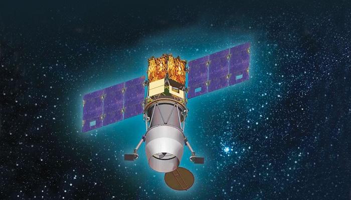
Illustration of the IAI's NanoSat- BGUSAT (Courtesy: IAI)

A new nanosatellite, the first for Israeli academia, will be launched into space on Wednesday to conduct scientific missions for the Ben-Gurion University of the Negev.

Get the Start-Up Israel's daily newsletter
and never miss our top stories
FREE SIGN UP!

BGUSAT is the result of a five-year joint project between BGU, Israel Aerospace Industries Ltd. (IAI) and Israel’s Ministry of Science, Technology and Space.

The satellite, 10x10x30 centimeters (4x4x12 inches) — a little bit larger than a milk carton — and weighing just five kilograms (11 lbs), is outfitted with innovative cameras that can photograph a large array of weather phenomena and a guidance system that allows operators to choose the areas to research through a dedicated ground station at BGU. Researchers will be able to position the satellite to take a variety of pictures from different angles.

It is the first time any Israeli university will have access to data from an Israeli nanosatellite for research purposes, BGU, IAI and the Israel Space Agency said in a joint statement Monday. Its unique orbital path close to Earth’s atmosphere will enable BGU and researchers at the Tel Aviv University to study scientific phenomena such as the Earth airglow layer.


BGUSAT’s logo respresenting David Ben-Gurion, the Negev, the earth and Israel (Courtesy: Tal Inbar and Igal Gabay)

Construction of the satellite began two years ago at IAI’s space division.

“This is another step in advancing cooperation between the government, industry and academia in order to promote the Israeli space industry,” Science Minister Ofir Akunis said in the statement. “Only such a collaboration with government backing will preserve the Israeli space industry’s global standing, and will promote research, create new jobs, all while safeguarding the essential interests of Israel.”

Nanosatellites are a new tool for academic scientific research, enabling space engineering and space research at prices that are affordable for academia, said Prof. Dan Blumberg, BGU’s VP and dean for R&D. “The reduced costs allow academia to assume a much more active role in the field taking advantage of the innovation and initiative of researchers and students,” he said in the statement.

Since large satellites are so expensive, not many risks can be taken that might jeopardize their mission, making satellite engineering walk a tightrope between being conservative and innovative. Since nanosatellites are cheaper, they offer a larger arena for space innovation, the statement said.

This new project “opens up the world of nanosatellites to new and varied scientific missions,” said Col. (res.) Ofer Doron, head of IAI’s MBT Space Division. “For the first time, a dedicated computer with computing power similar to those of the larger satellites, but developed specifically for nanosatellites by the space division, has been installed.”

This nanosatellite is part of a series of educational and academic activities that the IAI considers an integral part of the Israeli space industry, he said.

BGU students and researchers who worked on the BGUSAT integrated knowledge from a variety of fields such as software engineering, electrical engineering, planetary sciences, industrial engineering and management and more. This is the first project to showcase the enhanced space engineering capability that is being created at BGU. The goal is to be able to build a nanosatellite from scratch “in-house.”

Following the satellite’s launch, the Israel Space Agency has allocated an additional 1 million shekels to fund future research based on the data received from the satellite and has sent out a call for proposals. BGU and TAU have already submitted a joint proposal to study Earth’s airglow layer.

“We expect challenging ideas from the Israeli research community,” said Avi Belsberger, director of the Israel Space Agency. This is the first time that researchers will have the opportunity to receive information directly from an Israeli satellite, without having to go through other countries or research agencies, he said.

Through the BGUSAT cameras, researchers will be able to track atmospheric gases like CO2 in order to understand climate change, to examine changes in ground moisture that could be an indicator of desertification and affect agricultural development, and to monitor plant development in different regions.

BGUSAT will be launched Wednesday on the PSLV launcher from the Satish Dhawan launching pad in India along with 103 other nanosatellites.

http://www.timesofisrael.com/first-israeli-research-nanosatellite-set-to-launch/
 
India launches 104 nanosatellites into space, two of them Israeli
BGUSAT, developed by Ben Gurion University in collaboration with the Israel Aerospace Industries and the Ministry of Science, Technology and Space to study climate change and scientific phenomena from space.
Associated Press|Published: 15.02.17 , 17:27

India's space agency successfully launched more than 100 foreign nano satellites into orbit Wednesday aboard a single rocket, two of them Israeli.

The Indian Space Research Organization said the nano satellites—those weighing less than 10 kilograms (22 pounds)—were sent into orbit from the Polar Satellite Launch Vehicle from the Satish Dhawan launching pad in southern India. It said the launching of the 104 satellites was a record, overtaking Russia's feat of sending 37 satellites in a single launch in 2014.

"All 104 satellites were successfully placed in orbit," the Press Trust of India news agency quoted ISRO Chairman A.S. Kiran Kumar as saying. They included an Indian Earth observation satellite and two small technology demonstration satellites.


India launches the rocket carrying the nanosatellites into space (Photo: AFP)

It is the first time that any Israeli university will have access to data from an Israeli nanosatellite for research purposes.

“This is the first time that Israeli researchers will have the opportunity to receive information directly from a completely blue and white satellite, without having to go through other countries or research agencies,” said Avi Belsberger, director of the Israel Space Agency.

The Israel Space Agency in the Science Ministry, IAI and BGU launched the nanosatellite project five years ago while actual construction of the satellite began two years ago at IAI’s space division. “This is another step in advancing cooperation between the government, industry and academia in order to promote the Israeli space industry,” said Science Minister Ofir Akunis.

“Only such a collaboration with government backing will preserve the Israeli space industry’s global standing, and will promote research, create new jobs, all while safeguarding the essential interests of Israel,” Akunis further commented in a statement.


The BGUSAT (Photo: IAI)

Following the satellite’s launch, the Israel Space Agency has allocated an additional NIS 1 million to fund future research based on the data to be received from the satellite and sent out a call for proposals. BGU and TAU have already submitted a joint proposal to study Earth’s airglow layer.

“Nanosatellites enable space engineering and space research at costs that are affordable for academia. The reduced costs allow academia to assume a much more active role in the field taking advantage of the innovation and initiative of researchers and students,” said Prof. Dan Blumberg, BGU’s VP and Dean for R&D.

Through the BGUSAT cameras, researchers will be able to track atmospheric gases like CO2 in order to understand climate change, to examine changes in ground moisture that could be an indicator of desertification and affect agricultural development or to monitor plant development in different regions.

The other Israeli nanosatellite belongs to the company SpacePharma.

75895810100099360561no.jpg

The India rocket launching nanosatellites into space (Photo: EPA)

India's Prime Minister Narendra Modi tweeted that the "remarkable feat by ISRO is yet another proud moment for our space scientific community and the nation."

India has been striving to become a player in the multibillion-dollar space launch market, and has successfully placed light satellites into orbit in recent years. It hopes to eventually send astronauts into space.

In September 2014, India successfully guided a spacecraft into orbit around Mars. Only the United States, the former Soviet Union and the European Space Agency had been able to previously do that.

Yaron Druckman and TPS contributed to this report.

http://www.ynetnews.com/articles/0,7340,L-4922984,00.html

@Penguin @500 @Natan @Archdemon @GBU-28 @F-15I @mike2000 is back @Blue Marlin @Mountain Jew @Beny Karachun @Adir-M @Ilay @theman111 @Nilgiri
 
IAI's VENUS, OPTSAT-3000 Satellites Successfully Launched to Space


Israel's first environmental research satellite was launched Wednesday morning from French Guiana, together with the OPTSAT-3000 observation satellite, built for the Italian Ministry of Defense

IsraelDefense | 3/08/2017

Send to a friend
A+A-Size
Share on
Share on
146289258.jpg

The launch (Photo: Arianespace)

Two IAI-made satellites were successfully launched on board the Arianespace's Vega launcher early Wednesday morning at the Guiana Space Center’s Kourou site.

Israel's first environmental research satellite, Venus, is a major project of the Israel Space Agency and the French space agency CNES. It was launched together with the OPTSAT-3000, an advanced observation satellite designed for use by the Italian Defense Ministry.

Venus will revolve around the Earth 29 times within 48 hours and repeat exact photo angles, making it possible to note differences in conditions – characteristics that make the satellite unique, said the ministry.

IAI's President and CEO Yossi Weiss stated that the satellites are "the glory of Israeli technology and reflect Israel’s international activities in space and the extraordinary cooperation with Italy and France. The state-of-the-art observation satellites program enables the development and production of local needs and exports and is supported by clear government policy in the field."

Weighing only 265 kg., Venus reached its position of 720 km above Earth within 37 minutes and 18 seconds. The first sign with preliminary data was received on the ground 5.5 hours after launch, but the initial images will arrive a week later. Processed images will be sent to users three months after launch. Venus is due to remain in operation for 4.5 years, after which it will be shifted to a lower trajectory.

Some 110 research areas will be photographed around the world. When the satellite passes over Israel, Venus will photograph three swaths in the Galilee, the coastal area and the Negev where most national parks, forests, ecological stations and nature areas exist. The photos will also benefit university, government, and state research institutes.

The second satellite sent up from Guiana Space Center was the OPTSAT-3000, an Earth observation program for the Italian Ministry of Defense. It comprises a high-resolution optical satellite and a ground segment for in-orbit control, mission planning and the acquisition and processing of images.

The OPTSAT-3000 system is supplied by the prime contractor Telespazio, a joint venture between Leonardo and Thales. The satellite and ground control systems were built by Israel Aerospace Industries (IAI) and selected by the Italian Ministry of Defense. OHB Italia is responsible for the launch services and related engineering support.

Israeli-made Space Imaging Systems
The two satellites launched to space yesterday were equipped with advanced space imaging systems developed by Elbit Systems. The high-resolution reconnaissance Jupiter imaging system, for the Italian Ministry of Defense, was launched onboard the OPTSAT-3000 satellite, while the super spectral VENµS imaging system was launched onboard the French-Israeli Venus environmental satellite.

The Jupiter space camera provides spatial resolutions of 0.5-meter resolution (PAN) from an altitude of 600 km and is Elbit Systems’ most advanced light-weighted space imaging system developed for installation on micro and mini-satellites. The JUPITER imaging system contains very high-resolution panchromatic imaging and has the capability of adding a multi-spectral (MS) channel. JUPITER is designed for a range of military and civilian applications including advanced military surveillance and reconnaissance, detailed high-value target investigation, definition of small and discrete objects and situational awareness. The civilian applications include homeland security missions, emergency planning and operations, environmental monitoring, and infrastructure imaging.

The VENµS space camera features 12 narrow spectral bands with 5.3-meter spatial resolution from an altitude of 720 km. The VENµS satellite has been developed and manufactured as a joint effort between the French Centre National d' Etudes Spatiales (CNES), the Israeli Space Agency (ISA), Elbit Systems’ Electro-optics (Elop) and Israel Aerospace Industries. The VENµS imaging system provides multi-spectral high-resolution earth imaging, previously unmet by legacy space imaging systems for a variety of applications, including a global scale monitoring of agriculture, receding of forests and vegetation, desertification, air pollution, the detection of volcanic ashes, dehydration of water reservoirs as well as oil spills and water contamination. VENµS will play a vital role in creating guidelines for future scientific experiments and space imaging missions.


[Source: The Jerusalem Post]

http://www.israeldefense.co.il/en/node/30586
 

Back
Top Bottom