What's new

Chandrayaan sends images of Apollo 15 landing

ratolz

BANNED
Joined
Jul 20, 2009
Messages
178
Reaction score
0
PANAJI: A camera on board India's maiden unmanned lunar mission Chandrayaan-1 has recorded images of the landing site of US spacecraft Apollo 15,

a scientist said on Wednesday, rubbishing conspiracy theories that the fourth US mission to land on the moon four decades back was a hoax.

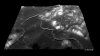
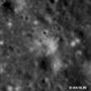
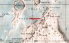
The Terrain mapper camera on board Chandrayaan-1, which had an abrupt end a few days back, has sent the prints of landing site of Apollo 15 and tracks of the lunar rovers used by astronauts to travel on lunar surface, a senior scientist associated with India's lunar mission said during a presentation here.

"The images captured by hyper spectral camera fitted as a part of Chandrayaan-1 image payload has reconfirmed the veracity of Apollo 15 mission," said Dr Prakash Chauhan, who is a senior scientist with Indian Space Research Organisation's(ISRO) Hyderabad-based space application centre.

Chauhan was presenting the findings of Chandrayaan-1 mission in his paper 'Chandrayaan I: TMC and HYSI data analysis for Apollo landing sites and Mare Orientale', which would be unveiled in public domain two months later, after further analysis.

The Chandrayaan-1 images have disproved the theory of conspiracy which had claimed that the Apollo 15 was a hoax, he said.

"Chandrayaan has managed to identify the landing site used by the Apollo 15 shuttle on the basis of the disturbances on the moon's surface," Chauhan said.

"Our images also show tracks left behind by the lunar rovers which were used by the astronauts to travel on the moon's surface," Chauhan said.

He said that since lunar dust is dark, the disturbances left behind by the spacecraft and the rovers are easily distinguishable.

"The disturbed surface is bright," he added. The scientist said Chandrayaan's images are an independent corroboration that can help dispel doubts about the NASA mission.

However, Chandrayaan's camera could not capture the images of footprint left behind by the first astronaut on moon, Neil Armstrong and Edwin Aldrin, because of its low resolution capability, he said.

Chauhan said that such an image is possible for a Lunar Reconnaissance Orbiter armed with high resolution camera launched into space by NASA.


Chandrayaan sends images of Apollo 15 landing - India - NEWS - The Times of India
 
When will these images be made public?

How did it find exact spot of the Apollo 15 landings?
 
attempt 2 please ur master(US).


real truth is Indians hve lost their contact from thier chandrayan mission satelitte.now dont say its a hoax.who supervised dat mission DRD0 ?? 
fail missile test, fail atomb, test , fail satelitte programme n fail state . :ROFL: :ROFL: :ROFL: :ROFL:


attempt 2 please ur master(US).


real truth is Indians hve lost their contact from thier chandrayan mission satelitte.now dont say its a hoax.who supervised dat mission DRD0 ?? 
fail missile test, fail atomb, test , fail satelitte programme n fail state . :ROFL: :ROFL: :ROFL: :ROFL:


Oh you mean Its failed even after sending more than 70,000 pictures, achieving 95% of its objectives and serving for 312 days in orbit.
You know what i think for you, you yourself are a failed man.:smokin:
 
When will these images be made public?

How did it find exact spot of the Apollo 15 landings?

very logical questions indeed. I am not amongst those who doubt the Apollo 15 mission but always wondered how would they recognize the landing place.

Even before Chandrayan mission reported this landing site , Japan's "Selene" reported the observation of Apollo 15 Landing side and compared it with 3D image of Terrain camera image in 2008. See the Article Below:

The "halo" area around Apollo 15 landing site observed by Terrain Camera on SELENE(KAGUYA)

May 20, 2008 (JST)

Japan Aerospace Exploration Agency (JAXA)

The Japan Aerospace Exploration Agency (JAXA) reported on the "halo" generated by the Apollo 15* lunar module engine exhaust plume that was detected in the data from Terrain Camera (TC) image.

This was an image processed by the SELENE mission instrument team from the observation data of the Apollo 15 landing site on the moon (the foot of the Apennine Mountains encircling the Mare Imbrium close to Hadley Rille). This is the world's first report on the detection of the "halo" through observations after the end of the Apollo program.

Through the produced three-dimensional image of the same landscape as that of the picture taken by the Apollo 15 crew, the spatial accuracy of the TC observation was verified. The three dimensional view of the TC clearly shows the layers of lava flows that erupted approximately about 3.2 billion years ago in the upper part of the Hadley Rille.

* The Apollo 15 was the ninth manned mission, and fourth lunar landing mission of the Apollo program. The Apollo 15 was launched on July 26, 1971 (JST), landed on the Moon on July 31, 1971, and then landed back on Earth on August 8, 1971. This mission was the first "J mission" and was primarily concerned with scientific research, and stayed longer on the Moon than previous Apollo missions.

9e43608c35dbfe8a700be16f612425f3.jpg

(Fig1) 3D view image of the Apollo 15 landing site obtained by TC
The "Falcon" Lunar Module of the Apollo 15 landed on the moon on July 31, 1971 (JST) near the Hadley Rille, at the foot of the Apennine Mountains encircling the Mare Imbrium. The Hadley Rille is a sinuous Rille with a length of 80km and depth of 300m. One of the missions of the Apollo 15 was to study the origin of this Rille. The Rille and the towering mountains near the Rille make this a place of scenic beauty.
This three-dimensional (3D) image was produced from stereo pair image data of the Terrain Camera (TC). The view point was set to show the Rille from the west at a height of 15km.

8776860d786816ac2eb3f2adb339e2c9.jpg

(Fig 2) Topographic map of the Apollo 15 landing site.
(The star mark is the landing site, and the red arrow stands for the view direction of Fig 1)
(reference: Lunar and Planetary Institute (LPI))

36458b2e603f4855a0a91994bf1e9c19.jpg

4c264175ee7df6e485237e9cff68374c.jpg

(Fig 3) The enlarged image where the area of the potential "halo" exists. (left image: 1 square kilometer in size. The inside of the red circle includes the potential "halo").
The reflectivity of the "halo" area became brighter than the original one by the Apollo 15* lunar module engine exhaust plume and the probable "halo" area was confirmed.

bfa0037c062d918ea017366502b7fbdb.jpg

(Fig 4) The lunar surface reflectivity change from before and after the landing
(provided from NASA (left image : AS15-87-11719, right image : AS15-9430))
Figure 4 shows the reflectivity change of the surface before and after the landing of the Apollo 15. The left image was taken obliquely from the descending lunar module. The right image was taken from the command service module from an altitude of 110 km on the second orbit of the Moon after the landing. The circle area includes the landing site, and the "halo" can be seen in the right image.

2292211c72ae5f547cac837448e33213.jpg
5a95ec5897b1bf552bcb3349eb4cb8d0.jpg

(Fig 5) TC 3D image and the picture taken by Apollo 15 astronaut. (left image : TC, right image : Apollo)
The viewpoint of the 3D image produced from TC stereo-pair data can be freely changed. The 3D image from TC data shows quite a similar landscape (left image) to the picture taken by the Apollo 15 crew (right image; provided from NASA: AS15-82-11122HR). Although the small objects (e.g. rocks) cannot be shown in this TC image because their respective sizes are less than the spatial resolution of the TC of 10 meters, the shape of the mountains and hills is almost the same, indicating the spatial observation accuracy of the TC is very high.
 

Attachments

  • 9e43608c35dbfe8a700be16f612425f3.jpg
    9e43608c35dbfe8a700be16f612425f3.jpg
    679.3 KB · Views: 15
  • 36458b2e603f4855a0a91994bf1e9c19.jpg
    36458b2e603f4855a0a91994bf1e9c19.jpg
    59 KB · Views: 14
  • 8776860d786816ac2eb3f2adb339e2c9.jpg
    8776860d786816ac2eb3f2adb339e2c9.jpg
    40.5 KB · Views: 17
Last edited:
contd....

80773d235b2d132cb0d63191e5be819f.jpg

(Fig.6) This still image is a cutout from the movie taken by the SELENE (KAGUYA) HDTV (telephoto camera) on January 29, 2008 (JST.). The Apollo 15 landing site, as well as the Montes Apenninus, Hadley Rille (in the left) and Archimedes crater (in the center) are seen in this image.

57437d5d9d0bcf2ed201ebe036a1e59b.jpg

(Fig 7) 3D view image around the Hadley Rille obtained by TC
During the Apollo 15 mission, astronauts also collected samples of mare basalt near the Hadley Rille. They confirmed that the Mare Imbrium was composed of many layers of lava flows, from several to ten meters in depth. The 3D view of the TC looking at the southeast direction from the northwest clearly shows the layers of lava flows on the upper parts of the Rille's wall. These layers were probably formed approximately about 3.2 billion years ago.


As for naysayers...well..they wont believe even if they are taken to the actual landing site itself...for them it would still be doctored, staged and blah blah:argh:
 
Last edited by a moderator:
"The images captured by hyper spectral camera fitted as a part of Chandrayaan-1 image payload has reconfirmed the veracity of Apollo 15 mission," said Dr Prakash Chauhan,

Where are those pictures taken by Chandrayaan that show the Apollo 15 landing site and the tracks left behind by its moon rover?
 
Back
Top Bottom