What's new

PM Imran Khan addresses to nation about new map of Pakistan

I can see many Indian @$$3$ burning on twitter already with this new development.:D

And I can see that unable to do anything about Indian merger of Kashmir your leadership is running like a headless chicken trying to satisfy a false ego among the common public by changing highway names and country maps....:partay:
 
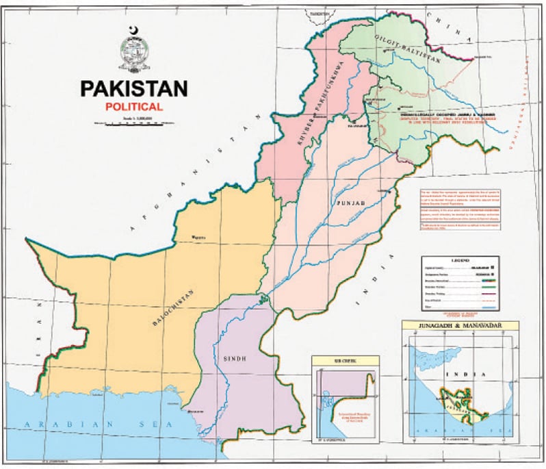
Pakistan affirms claim to IHK, Junagadh and Manavadar with new map

The Newspaper's Staff Reporter
Updated 05 Aug 2020

5f2a1989a560a.jpg

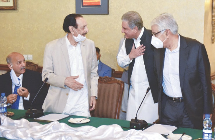
ISLAMABAD: Foreign Minister Shah Mehmood Qureshi meets opposition leaders just before the commencement of a conference on the Kashmir situation at the Foreign Office on Tuesday.—White Star


• PM hails map as first step towards resolution of Kashmir dispute
• Region’s description changed to Indian Illegally Occupied J&K

ISLAMABAD: The government on Tuesday unveiled a new political map of the country essentially asserting its longstanding position on Kashmir and Sir Creek disputes.

“It is a historic occasion. The political map reflects our national aspiration and supports our principled stance on Kashmir dispute,” Prime Minister Imran Khan said while introducing the map. He was on the occasion accompanied by his foreign policy, national security and information ministry aides.

ARTICLE CONTINUES AFTER AD
The map was launched after the approval by the federal cabinet. Foreign Minister Shah Mehmood Qureshi had earlier in the day briefed the legislators from opposition parties on the map during a meeting at the Foreign Office.

The new map was made public a day before Pakistan observes the first anniversary of annexation of occupied Kashmir.

India had annexed the held territory on Aug 5 last year by revoking articles 370 and 35A of its constitution, which had provided special status to occupied Kashmir and rights and privileges to Kashmiris.

The inauguration of the new map is, moreover, believed to be a response to India, which launched its own political map on Oct 31 last year after bifurcation of the disputed territory into so-called Union Territories of Jammu and Kashmir and that of Ladakh. India had through its map claimed the entire disputed area, including Azad Kashmir and Gilgit-Baltistan, as part of its territory.

ARTICLE CONTINUES AFTER AD
The Indian map was on that occasion rejected by China, Pakistan and Nepal.

PM Khan hailed the new map as the “first step” towards resolution of the nearly 73-year-old dispute. He, however, emphasised that Pakistan believed in a political solution to the dispute. He said the map rejected India’s illegal action of annexing held Kashmir.

Foreign Minister Qureshi, on this occasion, gave a presentation on the features of the new political map. He said the map clearly showed the disputed area, whose status Pakistan wanted to be decided in accordance with the UN resolutions and aspirations of the people of held Kashmir.

“It is first time that the aspirations of Pakistani nation and our stated position on the dispute are being given with such clarity,” he maintained.

ARTICLE CONTINUES AFTER AD
Special Assistant to the Prime Minister on National Security Moeed Yusuf, while talking to Dawn later, said the map asserted Pakistan’s claim on the territory, but had in no way suggested that the region was part of Pakistan. “We have just said that the dispute has to be resolved in accordance with UN resolutions,” he added.

Entire Gilgit-Baltistan and Kashmir had been given in the same green colour to show that it’s one territory, Mr Yusuf said, adding that the map also showed the changed nomenclature.

The government has changed the description of occupied region from Indian Occupied Jammu and Kashmir to Indian Illegally Occupied Jammu and Kashmir. It has been further clearly stated on the map that the region is disputed territory, whose “final status is to be decided in line with relevant UNSC resolutions”.

Mr Yusuf said the international boundary on the eastern side had been extended up to the undefined frontier to demarcate Indian territory of Himchal Pardesh from the disputed part of Jammu and Kashmir.

‘Frontier Undefined’ is another description that has been added to the map.

5f2a1989924dc.jpg


Mr Yusuf said it annotated that it would be defined after the Kashmir dispute was settled.

The claim on Junagadh and Manavadar too has been underscored. Moreover, an administrative boundary separating AJK and GB has also been inserted in the map.

Foreign Minister Qureshi at the ceremony held to inaugurate the map said the Line of Control had been extended and connected with the Chinese border. “This makes it clear that Siachen is ours,” he maintained.

An official, meanwhile, explained that the new map represented the position on Sir Creek, according to Sindh government’s agreement with the State of Kutch in 1914, demarcating the boundary on the Eastern Bank of Sir Creek.

Mr Qureshi said it negated Indian position with regards to Sir Creek. “India was cleverly trying to occupy hundreds of kilometers of our Exclusive Economic Zone,” he added.

The new map furthermore shows erstwhile Fata as part of Khyber Pakhtunkhwa province. Fata was merged with KP in May 2018 after 25th Amendment to the Constitution.

Indian reaction
Indian Ministry of External Affairs rejected the map as an “exercise in political absurdity, laying untenable claims to territories in the Indian State of Gujarat and our Union Territories of Jammu & Kashmir and of Ladakh”.

A statement issued from New Delhi said: “These ridiculous assertions have neither legal validity nor international credibility.”

FO response
The Foreign Office categorically rejected the statement made by the Indian external affairs ministry on Pakistan’s political map. “Through sophistry and obfuscation, India cannot create a smokescreen for its illegal and unacceptable actions in Indian occupied Jammu & Kashmir, including those taken since Aug 5, 2019. It is preposterous for a country that is compulsively expansionist, and a brazen practitioner of state-terrorism, to level charges against others,” the FO spokesperson said in a statement.

It said India had been in illegal occupation of parts of Jammu & Kashmir since 1947 and had continuously violated UN Security Council resolutions for decades. Despite its brutal suppression of Kashmiris for over 72 years, India had been unable to force them into submission, it added.

“Pakistan’s position remains clear and unambiguous. The solution of the Jammu and Kashmir dispute lies in the realisation of the Kashmiris’ inalienable right to self-determination through a free and impartial plebiscite under the auspices of the United Nations. The government, leadership and people of Pakistan remain firmly committed to the solution of the Jammu & Kashmir dispute in accordance with the relevant UN Security Council resolutions and the wishes of the Kashmiri people. The political map issued by Pakistan emphatically reaffirms this abiding commitment,” the FO said.

Published in Dawn, August 5th, 2020
 
Be careful your sanghi encryption can be decrypted anytime :lol:
So control your emotions :) Jay Arya verth

Why don't you ask some Sanghis? I can point them out to you, since spotting them is clearly not your strong point. That might give you some idea about the true verth of your verds.
 
Why is Pakistan not asking for the rest of Punjab?

Werent muslim majority states supposed to join Pakistan- in that case India/Brits screwed Pakistan by partitioning punjab/bengal when combined they were both muslim majority and should have gone to Pakistan....

Watch this:

 
For what is a plebiscite good for if Pakistan is not accepting the result of Junagarh?
 
So the official stance of Pakistan is that Kashmir should be shared between China and Pakistan.
No. The exact territorial boundary needs to be agreed. Why should we accept Kashmir's territorial boundary as the one India has marked it out to be?
 
For what is a plebiscite good for if Pakistan is not accepting the result of Junagarh?

If that had been done under UN supervision, rather than under Indian occupation then it would be accepted. This is no different than Saddam Hussains "free and fair" elections where he got 90-something percent of the vote.
 
See thread below.

What exactly do you find wrong with two sovereign states negotiating the specifics of a mountainous border?

Its your blatant hypocrisy that is in question here.
Your lot bang on about the right to self determination for Kashmiris when it comes to India, but somehow their (Kashmiri) opinion on whether YOU (Pakistan) even have the right to negotiate on Kashmiri land on their behalf somehow falls outside the purview of this apparent "self determination" and right of the Kashmiris.

Lets assume the Kashmir valley votes for Pakistan, their vote is to be part of Pakistan over India, NOT for you to receive their vote only for you to sell their land to the highest bidder. In this case, your benefactor, China.
Unless you plan to have another plebiscite between Pakistan and China.

What makes it worse here is that you bring up the UNSC resolutions, where China isn't even party to the conflict.
So do tell, Why in the first place is Pakistan negotiating with China about Kashmir without explicit permission of the Kashmiris? Where is their right to self determination now? Who is China in relation of the UNSC resolutions you love to reference?

And if the boundaries of Kashmir are so fluid, then what use is the UNSC resolution? Because from what I understand, the resolutions clearly define the area that is under dispute. If every party can change the definition of the boundaries of Kashmir, then the Indian abrogation of article 370 is perfectly legal given your opinion on the fluidity of the boundary. We just defined what we consider the "disputed territory". Now only [Mod Edit] Azad Kashmir is disputed. Funny how that works!

And who is Pakistan to decide the borders of Kashmir? Shouldn't the Kashmiris be the judge of that?
Or is it a matter of convenience for Pakistanis based on what works in their favor on that particular day?

Your moral high horse is the size of a donkey as far as we're concerned. And more importantly, the readers here can see it first hand, the blatant hypocrisy and moral bankruptcy at display.

Its a whole other matter that we laugh off your attempts to print some maps that have no value outside the narrow boundaries of the Pakistani state. Storm in a tea cup!
 
Last edited by a moderator:
Its your blatant hypocrisy that is in question here.
Your lot bang on about the right to self determination for Kashmiris when it comes to India, but somehow their (Kashmiri) opinion on whether YOU (Pakistan) even have the right to negotiate on Kashmiri land on their behalf somehow falls outside the purview of this apparent "self determination" and right of the Kashmiris.

Lets assume the Kashmir valley votes for Pakistan, their vote is to be part of Pakistan over India, NOT for you to receive their vote only for you to sell their land to the highest bidder. In this case, your benefactor, China.
Unless you plan to have another plebiscite between Pakistan and China.

What makes it worse here is that you bring up the UNSC resolutions, where China isn't even party to the conflict.
So do tell, Why in the first place is Pakistan negotiating with China about Kashmir without explicit permission of the Kashmiris? Where is their right to self determination now? Who is China in relation of the UNSC resolutions you love to reference?

And if the boundaries of Kashmir are so fluid, then what use is the UNSC resolution? Because from what I understand, the resolutions clearly define the area that is under dispute. If every party can change the definition of the boundaries of Kashmir, then the Indian abrogation of article 370 is perfectly legal given your opinion on the fluidity of the boundary. We just defined what we consider the "disputed territory". Now only [Mod Edit] Azad Kashmir is disputed. Funny how that works!

And who is Pakistan to decide the borders of Kashmir? Shouldn't the Kashmiris be the judge of that?
Or is it a matter of convenience for Pakistanis based on what works in their favor on that particular day?

Your moral high horse is the size of a donkey as far as we're concerned. And more importantly, the readers here can see it first hand, the blatant hypocrisy and moral bankruptcy at display.

Its a whole other matter that we laugh off your attempts to print some maps that have no value outside the narrow boundaries of the Pakistani state. Storm in a tea cup!

You sound like a Muppet while talking about Kashmiris rights
Equate how many Kashmiris are living in Peace in Azad Kashmir.
Unlike Indian Occupied Kashmir, where you lock them down in their homes, you place military installations and use of pallet guns, torture rape and murder history in Indian Occupied Kashmir.
After 370 imposed illegally, see what your politician said," You (Indians) will have license to marry white girls from Kashmir and live there"
Absurdity has become your natural morality when you spell “Kashmir”
Humanity spew your morality and you talk about Kashmiri rights?
All India did was to buy Hypocrite Politicians like Sheikh Abdullah in Kashmir.
 

Latest posts

Back
Top Bottom