Omar1984
ELITE MEMBER

- Joined
- Sep 12, 2008
- Messages
- 12,296
- Reaction score
- 0
Pakistans rejection of Indian stance on Sir Creek
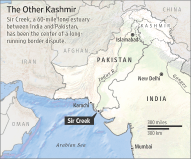
UNITED NATIONS, Jan 6 (APP): Pakistans strong challenge to Indias position on the Sir Creek estuary border dispute has been posted on the United Nations web site, saying Islamabad does not recognise the New Delhi-promulgated baseline system. The challenge is contained in a Dec 06 letter addressed to Secretary-General Ban Ki-moon by the Pakistan Mission to the United Nations in New York. Indias notifications enumerating its claims in regard to Sir Creek were placed on the web site of the UN Division for Ocean Affairs and the Law of the Sea in May and November 2009.
The 96-km estuary separates Indias Gujarat state from Pakistans Sindh province. The Indian claims impinge upon Pakistans territorial limits in Sir Greek area and encroach upon its territorial waters, which are within its sovereign jurisdiction, the letter tells the UN chief. This encroachment by India in Pakistans limits is a grave violation of international principles and established practices and clear violation of relevant article of the UN Law of the Sea Convention.
The articles state that the system of straight baseline may not be applied by a State in such a manner as to cut off the territorial sea of another state form the high seas of Exclusive Economic Zones.
While the Government of Pakistan reserves its right to seek suitable revision of this notification, any claim India makes on the basis of Indian Notification to extend its sovereignty and jurisdiction on Pakistani waters or extend its internal waters, territorial sea, Exclusive Economic Zone and Continental Shelf is therefore not acceptable to Pakistan, the letter added.
Associated Press Of Pakistan ( Pakistan's Premier NEWS Agency )


")

