What's new

Myanmar in Photos/News

Aung Zaya

SENIOR MEMBER
Joined
Mar 18, 2014
Messages
3,339
Reaction score
2
Country
Myanmar
Location
Thailand
lets me present all about Myanmar from here..

hope u get different taste... :D
All photos in here are credited..

Bagan is an ancient city located in the Mandalay Region of Burma (Myanmar). From the 9th to 13th centuries, the city was the capital of the Kingdom of Pagan, the first kingdom to unify the regions that would later constitute modern Myanmar. During the kingdom's height between the 11th and 13th centuries, over 10,000 Buddhist temples, pagodas and monasteries were constructed in the Bagan plains alone, of which the remains of over 2200 temples and pagodas still survive to the present day.
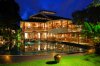
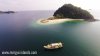
balloons-over-bagan-2-416655.jpg


temples-bagan-myanmar-balloon_85722_990x742.jpg


balloons-over-bagan-c11bf633-2b79-49bb-8b00-22b44b9aedc5.jpg


18111873115_53dcafd237_b.jpg


balloons-over-bagan.jpg


f5e288fcec6f70f5f6acb9a31b8deeea.jpg


asia-ballooning-over-bagan.jpg


balloon-636x330.jpg


thz bros... :D welcome from Myanmar.. !! :D

we have improved and still improving infrastructure of Bagan to attract more visitors.. we already more than 1.5 millions of tourists in last year.. and it will be offer a different taste from others like Angkor Wat Temple... :D
and we have some resorts to offer the best while u stay there...
here is one of them..

Aureum Palace Hotel & Resort Bagan


aureum-palace-resort.jpg


Aureum-palace-hotel-and-resort-01.jpg


Aureum-Palace-Lobby-Web.jpg


aureum-palace-hotel-resort1.jpg


spa.jpg


Aureum-Palace-Hotel-1-500-570x570.jpg


aureum-palace-hotel_046396_full.jpg

aureum-palace-hotel-resort.jpg
 
here is a news one hot spot.. !!

Mergui Archipelago
The islands of the Mergui Archipelago are one of the world’s last great archipelagos to remain largely untouched. Stretching from beneath Kawthaung in the South to the Maung Ma Kan Islands in the north a distance of over 600 miles.
With white sands and crystal clear waters, The 800 islands are home to the Salone people also known as Moken or Sea Gypsies who still maintain a largely nomadic life traveling between this great expance of idyllic islands.

11144954_1465542173768679_3100560235729037867_o.jpg

6.jpg

20150713011540Myanmar_Myeik_Cover-01.jpg


BruerIsland.jpg


EcoTour3Part12.jpg


EcoTour3Part12.jpg
 

Attachments

  • 115-island-myeik.jpg
    115-island-myeik.jpg
    85.6 KB · Views: 20
Musmeah Yeshua Synagogue (the Last Jewish house of worship )

Musmeah Yeshua Synagogue
(Hebrew: בית כנסת מושמאה ישוע‎) is the last remaining Jewish house of worship in Downtown Yangon and Burma's only synagogue. The temple stands nestled between Indian paint shops and Muslim traders on a small street near the city center. A plaque at the entrance of the building states that the present stone building which was built between 1893 – 1896 replaced an earlier, smaller wooden structure that was erected in 1854.[2] It is one of 188 sites on the Yangon City Development Council’s list of Heritage Buildings.[3] It serves the around 45 Jews of the country - mostly descendants of Sephardic Jewish Iraqis.

the-old-colonial-style-prayer-hall-of-the-musmeah-yeshua-jewish-synagogue-BNTB1P.jpg


synagogue.jpg


the Last Jewish Community
Ministervisit11.jpg
 

Attachments

  • synagogue.jpg
    synagogue.jpg
    420 KB · Views: 13
  • Burma1.jpg
    Burma1.jpg
    11.7 KB · Views: 15
Hkakabo Razi

Hkakabo Razi
(Burmese: ခါကာဘိုရာဇီ, pronounced: [kʰàkàbò ɹàzì]; simplified Chinese: 开加博峰; traditional Chinese: 開加博峰; pinyin: Kāijiābó Fēng) is Burma's highest mountain, and with its height of 5,881 m (19,295 ft) the highest mountain in South East Asia. It is located in the northern Myanmar state of Kachin in an outlying subrange of the Greater Himalayan mountain system near the border tri-point with China and India. Its highest status has recently been challenged by Gamlang Razi, 6.6 km WSW on the Chinese border.

01burmaclimb.ngsversion.1421072216989.adapt.1190.1.jpg


4551981076_a4c481ee69_b.jpg


MF15-STILL-Rinpoche Speaks Hi Res.jpg


MM8252_141108_020865.j.jpg

hkakabo-razi-opener-615.jpg
 
Amazing mate.. Myanmar in my go to list definitely..Wow !!!!.. One thing though hope all the tourism development would be environmentally sustainable.. Dont want such amazing unspoilt beauty get overwhelmed by over development and tourist hoards like Thailand and Bali
 
Last edited:
@Aung Zaya Wow this is truly amazing. Un -spoilt breathtaking one of the few places in the planet still like this. Are there any restrictions to travel within Myanmar?
 
Amazing mate.. Myanmar in my go to list definitely..Wow !!!!.. One thing though hope all the tourism development would be environmentally sustainable.. Dont want such amazing unspoilt beauty get overwhelmed by over development and tourist hoards like Thailand and Bali

u 're welcome..!! :D
We 're trying.. bro.. We wont follow the Thailand way..

Are there any restrictions to travel within Myanmar?

there is no restriction bro.. u can freely go there.. but the route to Hkakabo Razi still need to improve infrastructure.. and but we 're doing as best as we can with Myanmar Tourism Master Plan... :D

Goteik viaduct

The Goteik viaduct is a railway trestle in Nawnghkio, western Shan State, Myanmar (also known as Burma). The bridge is between the two towns of Pyin U Lwin, the summer capital of the former British colonial administrators of Burma, and Lashio, the principal town of northern Shan State. It is the highest bridge in Myanmar and when it was completed, the largest railway trestle in the world. The bridge is located approximately 100 km northeast of Mandalay.

The bridge was constructed in 1899 and completed in 1900 by Pennsylvania and Maryland Bridge Construction. The components were made by the Pennsylvania Steel Company, and the parts were shipped from the United States. The rail line was constructed as a way for the British Empire to expand their influence in the region. The construction project was overseen by Sir Arthur Rendel, engineer for the
Burma Railroad Company.


Bridge data
The viaduct stretches 689 metres (2,260 ft) from end to end with 15 towers which span 12 metres (39 ft) along with a double tower 24 metres (79 ft) long. The 15 towers support 10 deck truss spans of 37 metres (121 ft) along with six plate girder spans 18 metres (59 ft) long and an approach span of 12 metres (39 ft). Many sources have put the height of the bridge at 250 metres (820 ft). This is supposedly a measurement to the river level as it flows underground through a tunnel at the point it passes underneath the trestle. The true height of the bridge as measured from the rail deck to the ground on the downstream side of the tallest tower is 102 metres (335 ft). The cost of the bridge construction was 111,200 £(Pound sterling).[4]


Due to its technical and natural condition it was considered as a masterpiece of the world standard.

Now it's a lot older than me.. even than my grandpa.. :P Hope to like it.. it's now maintaining and not allowed for regular passengers.. but for tourists....

12033128_923739454371433_7823013154404755350_n.jpg


12036805_923739691038076_6982214703743161769_n.jpg


IMG_9639w.jpg


maxresdefault.jpg
 

Back
Top Bottom