Meet the work force behind India's strategic connectivity push in Ladakh
View attachment 907059
By Saikiran Kannan: “Our chiefs say we have plans to continue working throughout this winter and we are proud to be part of this world-class project,” says a gleaming staff part of the Zojila Pass tunnel construction project
View attachment 907060
“We know we are building very strategic roads and hence some pain is bound to be there, but we manage,” says another worker from Jharkhand who is now part of a shift that builds mountain roads near Nubra Valley.
Such are the testimonials from construction workers, part of many infrastructure projects along our borders which help connect critical and strategic places of interest for India as well as our neighbours.
With respect to securing the borders and developing the remotest parts of India, focusing on regions such as Leh, Hunder, Turtuk, Pangong Tso, Kargil and Srinagar along the Khardung La Pass, Chang La pass, the Zojila Pass, etc are vital. Many of the strategic infrastructure projects in progress across these areas will benefit India for decades to come. Here is a first-person documentation of the key infrastructural developments in these areas that will aid the Indian Army, the Border Security Force (BSF) and other agencies under critical situations and help mobilise troops far quicker than before.
With the recent December 9 clash between the Indian and Chinese troops in the Tawang sector, the importance of infrastructural development cannot be understated.
View attachment 907061
KEY INFRA DEVELOPMENT THROUGHOUT LADAKH UNTIL PANGONG TSO
With China almost having completed its second bridge across Pangong Tso in eastern Ladakh, India with the help of the Border Roads Organisation (BRO) and other agencies has been actively ramping up efforts to boost connectivity across these regions for quicker mobilisation of troops and machinery.
View attachment 907062
In the search to document the development of infrastructure along the borders, I explored places like Hunder and Turtuk after passing Khardung La and Nubra Valley, going as far as Merak (the last village in Pangong Tso), returned from Merak via the Chang La Pass to Leh and then proceeded towards Srinagar by passing through Kargil and witnessed the Zojila Pass under construction
Starting from Leh, the road infrastructure has been heavily upgraded along Khardung La, increasing access from Leh to the China front. The roads approaching Nubra Valley, Hunder and Turtuk are seeing constant upgradation in terms of road widening and relaying of the same. The village of Turtuk is a highly strategic place. It lies in the region of Baltistan, a region almost completely controlled by Pakistan. Turtuk is one of five Balti-populated villages under Indian control. Turtuk was under Pakistani control until the war of 1971, when the Indian Army captured the village. It is also one of the gateways to the highly critical Siachen Glacier
View attachment 907063
Further to this, earlier this year, the BRO increased the speed of connecting Nubra Valley to the DBO area. DBO stands for Daulat Beg Oldi and lies at the northeastern corner of the Karakoram Range, at the northern edge of the Depsang plains at an elevation of 5,100 metres (16,700 ft). The international border with China is 8 km north, and the Line of Actual Control with Chinese-controlled Aksai Chin is 9 km east. This will be an alternative, quicker way to reach the Depsang plains.
To get a sense of the ground work, I spoke with a few road construction workers and JCB machine operators employed by the BRO working across the stretches near Nubra Valley. Road widening and laying activities happen throughout the day and at high altitudes and extreme conditions. Ninety per cent of the construction activities happen in places where there are no toilets or tea shops and they only make do with temporary makeshift tents to rest a bit during the day
View attachment 907064
Most of the construction labourers were from Bihar and Jharkhand. They earn anywhere between Rs 12,000 and Rs 15,000 per month.
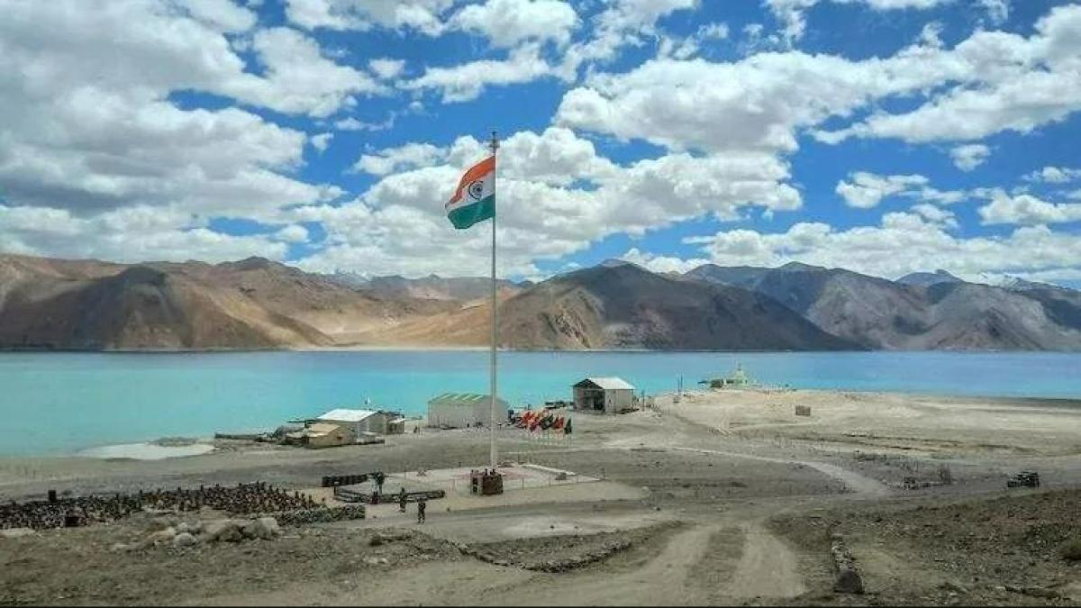
From Nubra, one must move eastwards towards the Shyok River and Durbuk to reach Lukung, the first village along the Indian side of the Pangong Tso. All these areas are also seeing heavy infrastructural development in terms of roads and other necessities. A couple of months ago, the BRO completed a 20-kilometre stretch of a highly important road that will help connect the Hot Springs in eastern Ladakh to the Lukung village on the Pangong lake.
The road is critical as the build-up with China at Hot Springs, one of the many friction points between the Indian Army and the Chinese People’s Liberation Army (PLA), continues despite disengagement in some areas
View attachment 907065
The entire stretch along the Pangong Tso on the Indian side has a fully enabled road infrastructure, making the traversal of the entire stretch of villages along the Indian side within 45 minutes. The roads connecting Durbuk to the Pangong area are being built at a fair pace. The return from Pangong to Leh can also be done much faster via the Chang La Pass once the road development across the pass is completed. This will offer a better alternative for quick mobilisation from Leh.
As of July, the BRO has built close to 2,100 km of roads in areas bordering China in the last five years. This number is seeing a constant addition each month. In February this year, Defence Minister Rajnath Singh announced that “the Capital Budget of BRO has been increased by 40% to Rs 3,500 crore in FY 2022-23 vis-Ã -vis Rs 2,500 crore in FY 2021-22. This will expedite the progress of the creation of border infrastructure”.
Jawahar Rufus, a bike rider who has been travelling across these terrains since 2018, said he has seen “tremendous improvements in the infrastructure over the last few years”. He also added the percentage of off-roading in these areas has reduced considerably, enabling many tourists to make it across such terrain.
View attachment 907066
View attachment 907067
Lokesh Kumar, another biker who has also been making yearly trips to these regions since 2016, added, “The places where there is a narrow path with no roads are getting widened. The places which had off-road sections are getting tarmac roads. There is constant improvement, and it will be a great advantage for the military for quicker mobilisation. On the other hand, Ladakh is losing its offbeat nature over the past few years and is super commercialised with the ever-increasing count of tourists
In September this year, India’s Chief of Army Staff General Manoj Pande commented that “maintaining a higher level of operational preparedness at all times and improving infrastructure, especially along the northern borders, were some of the key lessons from the eastern Ladakh border standoff”.
View attachment 907068
India has also been ramping up the construction of airfields and helipads along the LAC, stretching from Ladakh in the west to Arunachal Pradesh in the east. These airfields will be able to handle the landing of fighter jets besides the landing of large transport aircraft, ensuring uninterrupted logistical support to the troops deployed at the LAC.
View attachment 907069
View attachment 907070
CONNECTING LADAKH TO JAMMU & KASHMIR - THE ZOJILA TUNNEL
Ladakh is usually cut off from the rest of the country during harsh winters due to heavy snow. This is usually for four to five months each year. Now, the government has already completed the construction of the Atal tunnel which bypasses the Rohtang Pass and enables all-weather connectivity between Leh (Ladakh) and Manali. Lokesh, who has also done numerous Manali to Leh bike trips, said the Atal tunnel is a major gamechanger and the amount of off-roading on this stretch has greatly been reduced, aside from the all-weather connectivity
View attachment 907071
Now, another project, the Zojila Tunnel, is being developed to fix the road connectivity between Ladakh and Jammu and Kashmir during severe winters. Originally conceptualised in 2005, and the construction only starting in 2020, this is a 13 km-long tunnel that is expected to be ready by 2026. This tunnel will bypass the current four-hour-long stretch from Sonamarg to Minamarg/Meenamarg and enable the same traversal to happen in around 30 minutes with all-weather connectivity being the key aspect of the project.
View attachment 907072
This will provide direct, non-existing all-weather access between Ladakh and Jammu and Kashmir regions, which will give a huge strategic advantage to the Indian Army and other government agencies.
View attachment 907073
View attachment 907074
Work on this project has been going on non-stop and even through extreme low temperatures and heavy snowfall. Many of the construction workers were from other states like Jharkhand, but there were an equal number of locals who were proudly taking part in the laying of roads and building of the tunnel.
View attachment 907075
Ever since the relaxation of Covid restrictions, the Sonamarg area has seen a huge influx of tourists and they anticipate year-long business once the tunnel opens
With the recent December 9 clash between the Indian and Chinese troops in the Tawang sector, the importance of infrastructural development cannot be understated.

www.google.com
@bluesky @SIPRA @applesauce @INDIAPOSITIVE @beijingwalker @FOOLS_NIGHTMARE