What's new

Forts in Pakistan

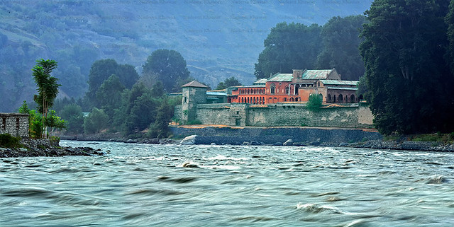
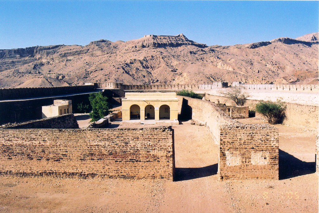
Some 25 kilometres west of Gujar Khan and over the Sui Cheemian perennial river sits the ancient Sangni Fort. This fort, used for keeping prisoners, is believed to have been built by the Mughals and later occupied by the Dogras of Kashmir and the Sikhs.

There are many such forts and fortresses in the Potohar region, which include the Rohtas, Attock, Pharwala, Rawat, Giri. However, the Sangni Fort, perched on a picturesque location overlooking two rivulets, is most spectacular.

55b36ee8204c5.jpg


Distant view of the Sangni Fort.


55b36ee337da8.jpg


The fort and spring.


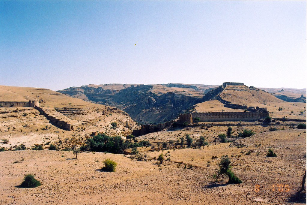
It is built over a hill from where one has a panoramic view of several villages, particularly the Sui Cheemian, Dhok Las, etc. The Dhole Las Village is noted for a 17th century necropolis. These graves are constructed of Kanjur stone and possibly belong to some of the soldiers of the Mughal period who were stationed at the fort. Similar graves can also be seen in the Takkal Village with dilapidated funerary enclosure, which possibly belongs to a Mughal administrator of Sangni and neighbouring villages.

The main entrance gate of the fort opens to the east from where one can see as far as the Takkal Village, steps lead to the inside of the fort.

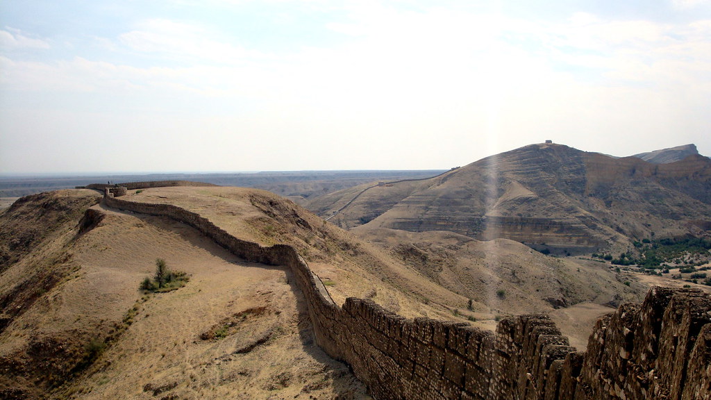
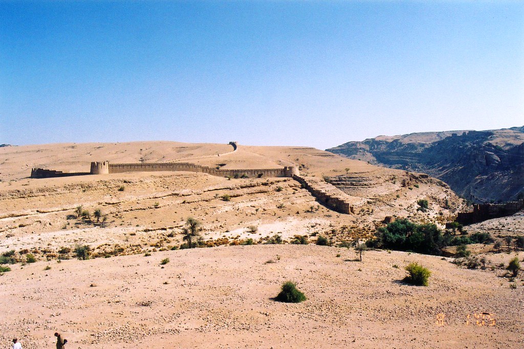
The fort has four bastions of almost equal diameter with stairways reaching the top of the bastions which were used for guarding the fort and its surrounding area.


55b36ee573283.jpg


A closer view of bastions of the fort.

55b36ef952063.jpg


The main gate of the fort.

Located inside the fort is a shrine of Abdul Hakeem. He is believed to have come from Arabia via Iran to preach in the area.


55b36f31babb3.jpg

A view of Sangni Fort from the west.
55b36f17e1f6a.jpg

A view of Abdul Hakeem's shrine.
A fabulous specimen of Potohar architecture, the tomb is said to have been built by his disciples.

It has three arched entrances from all directions. The tomb is constructed of marble. The hemispherical dome rests on the square building, the corners of which are decorated with four minarets.

The drum on which the dome rests is adorned with glazed titles. Close to the shrine is situated a mosque, which was also built by disciples of Abdul Hakeem.

The walls of the corridor are decorated with modern ceramics. The interior of the tomb is decorated with glasswork. The glazed tiles and glasswork are essential elements of the modern tomb architecture in Potohar. Almost in every village and town where there are shrines, one is bound to find these two forms of decoration on them.

55b36f0121b88.jpg


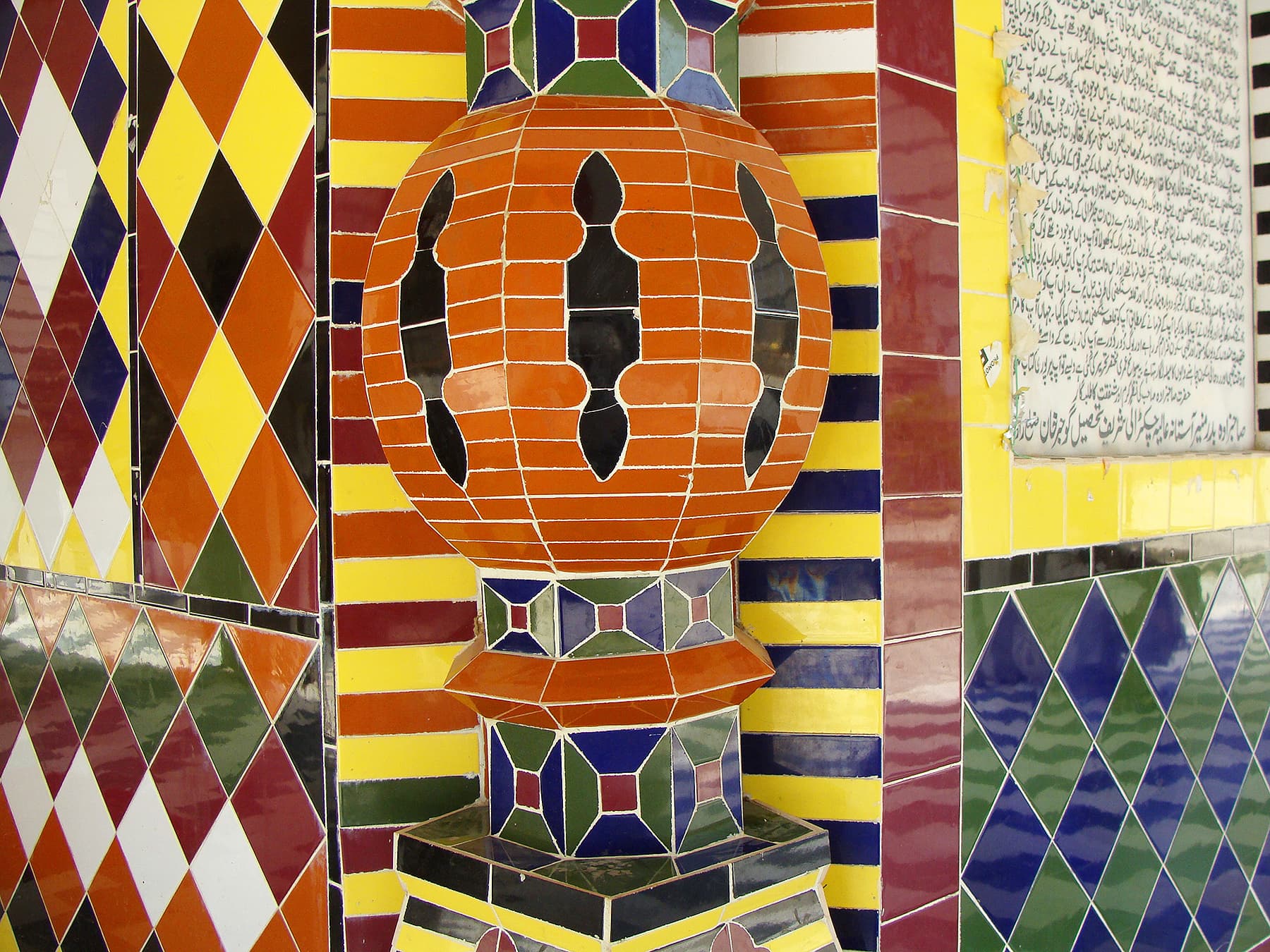
Modern ceramics on the wall of shrine.


55b36f0ea0e8f.jpg


The shrine.
The shrine of Abdul Hakeem attracts hundreds of people every Thursday and Friday. Newly married couples invariably visit the shrine to get the blessings of the saint. People also slaughter animals at the shrine in the hope of getting their wishes fulfilled and as a form of thanksgiving to the saint.

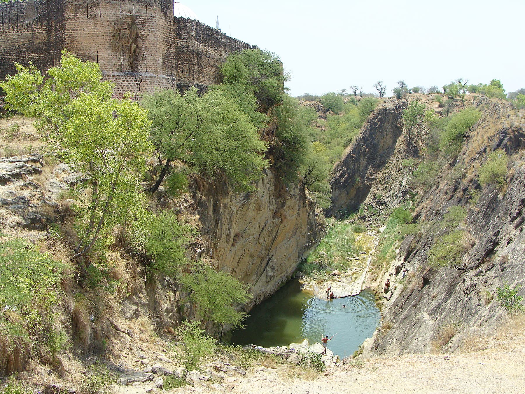
The devotees also take a bath in the spring which is situated west of the fort and is believed to have been a miracle of the saint.

Local people believe that there was no spring in Sangni until water came out from the earth where Abdul Hakeem was buried at the Sangni Fort. The spring never dries. Of the people taking a bath in it, some have illnesses that they hope the water will rid them of; water therapy is still a common practice at various shrines across Potohar.

Like the shrine, the fortress has also been maintained by the devotees of Abdul Hakeem.
 
Ramkot Fort, A.K, Pakistan

This fort is near Mangla dam and the location on top of a steep hill dominates the area. Again this right next to River Jhelum and not too far from the battle Alexander had against the local ruler Porus on the banks of Hydaspes. The climate in this region temperate wet.

It would be a job to break into this fort as long as the defenders held their ground.

1092938d1355203258-impromptu-gtg-travellers-group-ramkot-fort.jpg


10024995125_cfe3707cde_b.jpg


^ Chitral fort - Scene of fighting with British when they annexed this area because they were concerned about Tzarist Russian expansion south into Central Asia and the 'great Game'.

The British Chitral Expedition 1895........................
 
Attock fort and Indus river bridge

15107262_1183722711709192_7997528718186909491_n.jpg

_
 
Kotdiji Fort, Sindh

More than 215 years old

15578290_762613510555543_6896609868431389280_o.jpg
 
Noor mahal? Abbasi mahal? I didn't see them
@ghazi52 @KediKesenFare
though these are palaces... but must had fortification walls so can be considered fort.. there can be fort of Kherpur state (sindh) Mirpur (of Talpurs which is included)
 
Last edited:
Rohtas' Fort, Jhelum


18274746_1356935297721265_5738354131681267737_n.jpg


Ranikot Fort in Pakistan - The world's largest fort
Ranikot Fort is the world's largest fort with a circumference of about 26 km or 16 miles.Since 1993, it has been on the list of tentative UNESCO World Heritage Sites.

Location
It is located in the Kirthar Range, about 30 km southwest of Sann, in Jamshoro District, Sindh, Pakistan. It is approximately 90 km north of Hyderabad.

Dimensions
It has an approximate diameter of 6 km. Its walls are on the average 6 meters high and are made of gypsum and lime cut sandstone and total circumference is about 20 km. While originally constructed for bow and arrow warfare it was later expanded to withstand firearms.

It is reputed to be the largest unexplored fort in the world. The purpose of its construction and the reason for the choice of its location are still unknown.

Ranikot is the most talismanic wonder of Sindh. Visible from five kilometers away its massive undulating walls twist and dip over the hills. With the circumference of about twenty kilometers, its walls, built with dressed sandstone and reinforced with 45 bastions along the outer wall, of which 7 are rectangular and the remaining are round. All modified through the ages to accommodate the use of gunpowder, this perhaps makes it the largest fort in the world.

History
The original purpose and architects of Ranikot Fort are unknown. Some archaeologists attribute it to Arabs, or possibly built by a Persian noble under the Abbasids by Imran Bin Musa Barmaki who was the Governor of Sindh in 836 CE. Others have suggested a much earlier period of construction attributing to at times the Sassanians Persians and at times to the Greeks. Despite the fact that a prehistoric site of Amri is nearby, there is no trace of any old city inside the fort and the present structure has little evidence of prehistoric origins.

Archaeologists point to 17th century CE as its time of first construction but now Sindh archaeologists agree that some of the present structure was reconstructed by Mir Karam Ali Khan Talpur and his brother Mir Murad Ali in 1812 CE at a cost of 1.2 million rupees (Sindh Gazetteer, 677).

Fort Ranikot is located in Lakki Mountains of the Kirthar range on the right side of the mighty River Indus at a distance of about 30 kilometers from the present day town of Sann. A mountainous ridge, Karo Takkar(Black Hill), running north to south, forms its western boundary and the 'Lundi Hills' forms its eastern boundary. Mohan Nai, a rain-stream enters the fort from its rarely used western 'Mohan Gate', where it is guarded by a small fortification, changes its name to 'Reni' or 'Rani Nai' or rain-stream and gives the fort its name. Ranikot is thus the 'fort of a rain stream' - Rani. It runs through it, tumbles in a series of turquoise pools to irrigate fields and leaves the fort from its most used 'Sann Gate' on the eastern side. It then travels about 33 kilometers more to enter the Lion River - Indus.

Most of the twenty six kilometers long wall is made of natural cliffs and mountains which at places rise as high as two thousand feet above sea level! Only about 8.25 km portions of its wall are man-made, built with yellow sandstone. This was first measured on foot by Badar Abro along with local guide Sadiq Gabol. As one enters the fort, one can find hills, valleys, streams, ditches, ponds, pools, fossils, building structure, bastions, watchtowers, ammunition depots, fortresses - all inside Ranikot, adding more to its beauty and mystery. A spring emerging from an underground water source near the Mohan Gate is named as 'Parryen jo Tarr' (the spring of fairies).

According to a tale told by the local inhabitants, fairies come from far and wide on the Ponam Nights (full moon) to take bath at this spring near 'Karo Jabal'! Splashing sounds of water falling on the rocks can be heard at another spring, Waggun jo Tarr or "the Crocodile Spring", named so as crocodiles once lived there.

Within Ranikot, there are two more fortresses - Meeri and Shergarh, both have 5 bastions each. Meerikot takes its name from the word 'Mir' meaning top (for instance the top of a hill, chief of any Baloch tribe, etc.). Both the main Ranikot and the inner Meerikot have similar entrances - curved, angulated with a safe tortuous path. From the military point of view, Meerikot is located at a very safe and central place in the very heart of the Ranikot with residential arrangements including a water-well.

Talpur Mirs used Meerikot as their fortified residence. One can explore ruins of the court, harem, guest rooms, and soldiers quarters inside it. Its 1435 feet long wall has five bastions. Every structure in the Ranikot has its own uniqueness and beauty. Looking up from Meerikot one can find another fortified citadel - Shergarh (Abode of Lions) built with whitish stone, it too has five bastions. Though its location at 1480 feet above the sea level makes this fortress a unique structure, it also makes it equally difficult for supply of water, which can only be had from the brooks and rain streams, hundreds of feet below.The steep climb up to Shergarh gives a commanding view down over the whole fort and its entrance and exit points. On a clear day one can even see Indus, 37 kilometers away to the east.

Beside the Mohan Gate and the Sann Gate, there are two more gates, rather pseudo gates. One is towards the side of ancient town of Amri. This 'gate' is called the 'Amri Gate'. Certainly it takes its name from the prehistoric ruins of Amri, but it must have taken this name much later than the times of Amri as the fort itself doesn't appears to be as old as the Amri itself. In fact there is a bridge over rain stream 'Toming Dhoro' exiting from the fort called 'Budhi Mori'. The breach in fort wall due to the river stream has been referred as a gate. Similarly, the Shahpir Gate to the south also appears to be a pseudo gate taking its name from a limestone rock with a rough shape of foot imprinted on it. The sacred footprint supposedly belongs to Hazrat Ali or some other religious personality and is venerated by locals. It seems to be a later breach in the fort wall instead of a formal gate because one can't find any bastion or watchtower or their remains at the site, needed to guard any formal entrance or exit points.

A mosque found in the fort appears to be a later modification of a watchtower or a later construction. Scattered animal skeletons and prehistoric fossils can be found on the top of Lundi Hills. One of the three graveyards has about four hundred graves made of Chowkundi like sandstone with engraved motifs of sunflowers and peacocks. Whether we can call them as theriomorphic and phytomorphic motifs is an open question. Another one appears to be a graveyard of Arabs. The third one, about a mile away from the Sann Gate, had sixteen or seventeen graves earlier but now there are only four graves. The local inhabitants call it the Roman's graveyard.

Current Inhabitants
Currently, only the Gabol Baloch tribe occupies the area within Ranikot. The area has become a virtual village for the Gabol's over the past century who earn their livelihood by offering tours to many of the visitors, as well as by small scale farming. Today, the Gabol tribe chief Nabil Gabol is trying to attract the Sindh government's funds to develop the area into an international tourist site.

Research
"The size of Ranikot defies all reasons. It stands in the middle of nowhere, defending nothing" writes Isobel Shaw. So why was this fort built here in the desolate terrain of the Kirthar range? Many theories have been developed to answer this question. According to Ishtiaq Ansari, the Talpurs had sent their families to Thar and Kachchh when Afghan's attacked Sindh during the times of Kalhoras. However, after acquiring the rule of Sindh, they wanted a safe and secure place where they can send their families during the troubled times. This might have prompted them to rebuild this fort to their needs. Rahimdad Khan Molai Sheedai holds view that its location in Kohistan on the western frontiers of Sindh gave it its strategic value. Whereas Mazher Ansari is of the opinion that, it was first constructed in the Achaemenid Dynasty of the Persian Empire (550 - 330 BC). As this empire stretched from Turkey in the west, where a similar wall is constructed near the Caspian Sea called The Great Wall of Gorgan, which is 155 km in length and to the east up to River Indus in Sindh, where this majestic fort is located.

Access to this man-made marvel of ancient times is possible through a mettled road, which goes up to Meeri Kot.

http://en.wikipedia.org/wiki/Ranikot_Fort

image hosted on flickr
5115850946_41a7f0ea7f_b.jpg


399911123_8e556771b4_b.jpg


399911136_3a7642971c_b.jpg


399865586_7bf549e8c5_b.jpg


399911132_0e208303a4_b.jpg


399865581_7a6fa85c66_b.jpg


399911140_7bc989b5d8_b.jpg
 

Back
Top Bottom