Around 90pc fires in Margalla Hills work of villagers: IWMB
Ikram Junaidi |
Jamal ShahidPublished May 30, 2021 - Updated 37 minutes ago
Facebook Count
Twitter Share
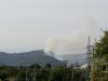
This file photo shows smoke rising from a fire in the Margalla Hills. — White Star
ISLAMABAD: About 80 to 90 per cent of fires in the Margalla Hills National Park are the work of residents of surrounding villages, Islamabad Wildlife Management Board (IWWB) Chairperson Rina Saeed Khan told
Dawn on Saturday.
Every summer the Capital Development Authority (CDA) inducts nearly 400 villagers on daily wages to patrol and spot forest fires. “But those who are not inducted, set forests on fires in retaliation,” Ms Khan said.
In 2017-18, arsonists caused nearly 50pc damage to the forest area spread across 200 square kilometers. Fortunately, rains kept damage to a minimum last year.
This time, forest fires could be seen from D-12 on Trails 3 and 5 and across Bari Imam. Even Trail 6, one of the pristine conservation areas, was also set ablaze for the first time in 15 years.
“This time, we saw someone setting fire in different patches. Our staff tried to give chase but lost the arsonist in the darkness. The villagers are familiar with the terrain and move fast,” she said.
She said everything was so dry in the fire season, including springs, the shrubs and the pines, that the forest caught fire and spread quickly.
Ms Khan said she had at her disposal only 50 staff members. She said the fires were preventable but CDA did not cooperate and refused to assist the IWMB in making the park better.
“We are the custodian of the national park but we are still a small setup. The parliament should formulate IWMB rules, giving us more powers to hire more staff and have more funding without which we are helpless.”
Though forest fires clear shrubs and let the forest floor catch some sunlight, they were extremely bad for the wildlife especially for the nesting birds as the breeding season is underway, she said.
“We now have funds to use drones to monitor and for surveillance purposes,” she said, explaining that fighting fires was dangerous for her staff.
She reminded trekkers that all the trails were closed to let the fire staff do their job in fighting the forest fires. She said with better coordination among all government departments, fires could be prevented.
Fire fighting operations continue
Capital Development Authority (CDA) Chairman Amer Ali Ahmed on Saturday inspected a fire fighting operation in Margalla Hills National Park.
He encouraged the teams from various civic agencies jointly carrying out all such operations.
Instructions were issued to environment formations to monitor the area and ensure to prevent any fire incident which may occur due to the hot weather.
He further instructed that police, water bowsers and all fire fighting equipment be present in the vicinity to initiate prompt response.
The chairman stressed the need for engaging the local population to prevent such accidents and getting timely information about the locations.
He said it is a challenge which can only be overcome with joint efforts of civil society organisations, local population and all other government organisations.
A number of fire incidents were reported in the Margalla Hills during the current week.
Director Environment Regional Rana Tahir, who headed the fire fighting operation on Saturday, claimed that after five-hour-long efforts the fire was brought under control. He said apparently the cause of the fire was human error as someone might have thrown a burning cigarette into dried bushes which caught the fire. However, a fire later again broke out on the hills.
Spread over 12,605 hectares, the Margalla Hills National Park witnesses fire incidents in the summer every year.
Meanwhile, CDA’s Member Finance and spokesperson Rana Shakil Asghar said that in accordance with the vision of Prime Minister Imran Khan the CDA was giving a new look to the federal capital.
He was speaking at a flag-hoisting ceremony held at Faisal Avenue greenbelt. He said maintaining respect for the national flag was the top priority of the department.
“This flag is the symbol of independence. It will be hoisted with the rising sun and lowered with the setting sun.” He said the CDA had assigned special duties to its workers for this purpose. The flag was hoisted here in 2014.
“But due to the negligence of the previous administration it could not be maintained. However, the flag has been hoisted again due to the interest of the current administration of CDA,” he said.
Published in Dawn, May 30th, 2021


 E2ZJ-5pWUAMalSA.jpg289.2 KB · Views: 41
 E2FoQkEXsAEeek0.jpg225.6 KB · Views: 33
 Delta Burn Area Map MG Hills 2018.png865.8 KB · Views: 30
 AWWSPQ.png1.1 MB · Views: 43
 Daily average maximum temp.png1.1 MB · Views: 43
 1622279797575.jpeg13.3 KB · Views: 28
 1622280072238.jpeg7.2 KB · Views: 30
 E2DnJKLXsAAtniG.jpg102.7 KB · Views: 36


