What's new

BDS-Beidou Navigation Satellite System Completed ! [From China For The World]

Daniel808

SENIOR MEMBER
Joined
Nov 24, 2013
Messages
4,960
Reaction score
-8
Country
Indonesia
Location
Indonesia
1080x360.jpeg


The launch of the completion Satellite scheduled for Tomorrow, June 16th 2020. A historic day indeed :cheers:


06d7ab4080dc4a47c323393e7406985f.jpg


beidou_china_GPS.jpeg


Will be updated soon :enjoy:
 
Last edited:
How good it is in front gps?
China set to complete Beidou network rivalling GPS in global navigation this month

JUNE 12, 2020 / 11:49 AM / UPDATED 20 MINUTES AGO

BeiDou-Navigation-Satellite-System.jpg


BEIJING (Reuters) - The Chinese Beidou navigation network will be complete this month when its final satellite goes into orbit, giving China greater independence from U.S.-owned GPS and heating up competition in a sector long dominated by the United States.

The idea to develop Beidou, or the Big Dipper in Chinese, took shape in the 1990s as the military sought to reduce reliance on the Global Positioning System (GPS) run by the U.S. Air Force.

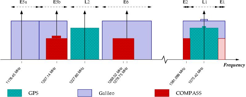
When the first Beidou satellites were launched in 2000, coverage was limited to China. As use of mobile devices expanded, China in 2003 tried to join the Galileo satellite navigation project proposed by the European Union but later pulled out to focus on Beidou.

In the age of the iPhone, the second generation of Beidou satellites went operational in 2012, covering the Asia-Pacific.

China began deploying the third generation of satellites aimed at global coverage in 2015.

The 35th and final Beidou-3 satellite will be launched this month - the day has yet to be announced - meaning Beidou has more satellites in its system than GPS’s 31, and more than Galileo and Russia’s GLONASS.

With estimated investment of $10 billion, Beidou keeps the communications network of the Chinese military secure, avoiding the risk of disruption to GPS in the extreme event of conflict.

Weapons targeting and guidance also improves. When complete, Beidou’s location services are accurate down to 10 cm in the Asia-Pacific, compared with GPS’s 30-cm range.

“Beidou was obviously designed a few decades after GPS, so it has had the benefit of learning from the GPS experience,” said Andrew Dempster, director of the Australian Centre for Space Engineering Research.

“It has some signals that have higher bandwidth, giving better accuracy. It has fewer orbit planes for the satellites, making constellation maintenance easier.”

SPACE SILK ROAD
Beidou-related services such as port traffic monitoring and disaster mitigation have been exported to about 120 countries, state media reported.

Many of those countries are involved in the Belt and Road initiative, spearheaded by President Xi Jinping to create a modern-day Silk Road of trade and investment.

In a 2019 report, the U.S. congressional U.S.-China Economic and Security Review Commission warned that China promoted launch services, satellites and Beidou under its “Space Silk Road” to deepen reliance on China for space-based services, potentially at the expense of U.S. influence.

Thailand and Pakistan were the first foreign countries to sign up for Beidou’s services, in 2013.

Within China, more than 70% of mobile phones were Beidou-enabled as of 2019, state media reported, including models made by Huawei [HWT.UL], Oppo, Xiaomi, Vivo and Samsung.

Millions of taxis, buses and trucks were also able to receive Beidou signals.

China’s satellite navigation sector may top 400 billion yuan ($57 billion) in value this year, state media said.


Ahead of the Beidou-3 completion, satellite-related shares have soared.

Beijing BDStar Navigation Co, which makes chips that receive Beidou signals, has surged 34.4% this year. Hwa Create leapt 52.3%, outpacing the 7.6% gain in the Shenzhen benchmark.

https://ca.reuters.com/article/technologyNews/idCAKBN23J0I9-OCATC
 
I bought a bike speedometer I think it works with Beidu GPS satellite.
 
How good it is in front gps?


Because you asking from Bahrain.
Then the answer, Beidou is much much better than gps


The 35th and final Beidou-3 satellite will be launched this month - the day has yet to be announced - meaning Beidou has more satellites in its system than GPS’s 31, and more than Galileo and Russia’s GLONASS.

With estimated investment of $10 billion, Beidou keeps the communications network of the Chinese military secure, avoiding the risk of disruption to GPS in the extreme event of conflict.

Weapons targeting and guidance also improves. When complete, Beidou’s location services are accurate down to 10 cm in the Asia-Pacific, compared with GPS’s 30-cm range.

“Beidou was obviously designed a few decades after GPS, so it has had the benefit of learning from the GPS experience,” said Andrew Dempster, director of the Australian Centre for Space Engineering Research.

“It has some signals that have higher bandwidth, giving better accuracy. It has fewer orbit planes for the satellites, making constellation maintenance easier.”


https://ca.reuters.com/article/technologyNews/idCAKBN23J0I9-OCATC


Thanks for EU Galileo (satellite navigation) cooperation ban. Galileo is not going smoothly.

Animation of BeiDou-3

Around the Earth

Around the Earth - Polar view

Earth fixed frame - Equatorial view, front

Earth fixed frame - Equatorial view, side

Gps_compass_galileo_frequency_allocation_Asimsky_05_2008.jpg


Beidou2 Accuracy[edit]
There are two levels of service provided – a free service to civilians and licensed service to the Chinese government and military.[27][55] The free civilian service has a 10-metre location-tracking accuracy, synchronizes clocks with an accuracy of 10 nanoseconds, and measures speeds to within 0.2 m/s. The restricted military service has a location accuracy of 10 centimetres,[56] can be used for communication, and will supply information about the system status to the user.

To date, the military service has been granted only to the People's Liberation Army and to the Pakistan Armed Forces.[57][58][59]

I believe Beidou3 accuracy will be much better due to new hydrogen maser clock.
 
This is the last US technological monoply that I can think of, but now this last monoply is being removed.
Internet!

when China invents chinese Internet?

Thanks for EU Galileo (satellite navigation) cooperation ban. Galileo is not going smoothly.

Animation of BeiDou-3

Around the Earth

Around the Earth - Polar view

Earth fixed frame - Equatorial view, front

Earth fixed frame - Equatorial view, side

Gps_compass_galileo_frequency_allocation_Asimsky_05_2008.jpg


Beidou2 Accuracy[edit]
There are two levels of service provided – a free service to civilians and licensed service to the Chinese government and military.[27][55] The free civilian service has a 10-metre location-tracking accuracy, synchronizes clocks with an accuracy of 10 nanoseconds, and measures speeds to within 0.2 m/s. The restricted military service has a location accuracy of 10 centimetres,[56] can be used for communication, and will supply information about the system status to the user.

To date, the military service has been granted only to the People's Liberation Army and to the Pakistan Armed Forces.[57][58][59]

I believe Beidou3 accuracy will be much better due to new hydrogen maser clock.
10m accuracy for general public?

I hope that is a joke.

Because you asking from Bahrain.
Then the answer, Beidou is much much better than gps


The 35th and final Beidou-3 satellite will be launched this month - the day has yet to be announced - meaning Beidou has more satellites in its system than GPS’s 31, and more than Galileo and Russia’s GLONASS.

With estimated investment of $10 billion, Beidou keeps the communications network of the Chinese military secure, avoiding the risk of disruption to GPS in the extreme event of conflict.

Weapons targeting and guidance also improves. When complete, Beidou’s location services are accurate down to 10 cm in the Asia-Pacific, compared with GPS’s 30-cm range.

“Beidou was obviously designed a few decades after GPS, so it has had the benefit of learning from the GPS experience,” said Andrew Dempster, director of the Australian Centre for Space Engineering Research.

“It has some signals that have higher bandwidth, giving better accuracy. It has fewer orbit planes for the satellites, making constellation maintenance easier.”

https://ca.reuters.com/article/technologyNews/idCAKBN23J0I9-OCATC

But Beido is only available for some.
Pakistan and Thailand.
Not what you claim it is for the world.

If for the world, can Vietnam join the service?
Our shore artillery needs better accuracy.
 
Internet!

when China invents chinese Internet?


10m accuracy for general public?

I hope that is a joke.


But Beido is only available for some.
Pakistan and Thailand.
Not what you claim it is for the world.

If for the world, can Vietnam join the service?
Our shore artillery needs better accuracy.
upgrade the hardware first.
 
upgrade the hardware first.
Which hardware?

you realize 10m accuracy is useless for most applications today?

10m is longer than the length of 2 cars together. Totally useless in car navigation!
 

Back
Top Bottom