1635 Netherlands:
This figure, the top of the long strip Note Doa Javaquero, right indicate Pracel, on the left coast of Vietnam on Pulo S Polo, Pulo Cotan, Lan tam, a long strip at the bottom of Pulo Citi
1680 Netherlands:
Long strip superscript Pracel, On the left labeled Pulo Cham, Strip form began to close to Vietnam coast , Nansha Islands in the lower right corner of display.
1747 United Kingdom:
The long rectangular label of Shoal of Pracel, The top right of a few small islands marked as "the Triangle", Xisha Islands from a long strip of "Paracels" separation, independent of an archipelago
1750 United Kingdom:
Long strip marked with "Pracel its upper right is the separation of a separate Islands labeled" of Li Ochiali
1775 United Kingdom:
Long strip marked with "Pracel its upper right is the separation of a separate Islands labeled" of Li Ochiali
1812 United Kingdom:
Long strip marked with "Pracel its upper right is the separation of a separate Islands labeled" Amphitrite, Dry Lime Shoali
1851 United Kingdom:
This diagram Note North Sh (oa) l, Paracels, Amphitrite Is, Crescent, Discovery Shoal, Bombay Shoal, Macclesfield Bank, Scarborough Shoal and other words, the various reefs group label has basically modern naming. a very modern map began on the map to remove the long strip, But the “Paracels” this name transferred to now the real xisha islands.
Western understanding of the China Sea is the ancient Chinese map in the transmission of information, Once the central Vietnam coast not far from some of the shoals, sandbars painted a long strip, And called Parcel / Pracel (s) / Paracels, But Until 1747, they discovered that the Xisha Islands of China, And began to draw in the upper right corner of the long strip of the Xisha Islands, and gave several different names, Later, a very modern (for example ,1851 United Kingdom) map began on the map to remove the long strip, But the “Paracels” this name transferred to now the real xisha islands.
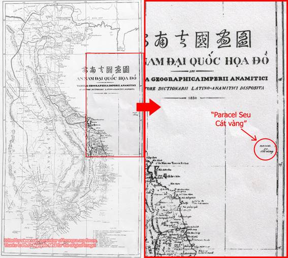
《The Complete Map of Unified Great Nam》,Longitude point of view, these two Islands is too close to the coast of Vietnam, After all, this time in the 19th century, other territories in Vietnam is probably more accurately described why such a big difference of the two Islands? Latitude and Islands and the distribution of the shape difference is also great, from the map, the two Islands together to form a long strip, but in fact the Paracel Islands and Spratly Islands are far apart, the distribution is not a long strip, At this time no matter how backward mapping technology, nor will the two Islands to draw so close! Contrast map of the Western release above, we can find, “黄沙" and "萬里長沙”, In fact, from the 1613 British Captain John Sullivan wrote 《Sailing log 》, Map described in the "long zone". Regardless of position or shape point of view, the two maps are the same. In the long strip zone on the map, The top label (Pulon Cham), Central label (Pulou Canton), Bottom marked(Pulou Gambir). It can be predicted this long zone(《The Complete Map of Unified Great Nam》“黄沙"and"萬里長沙”
")
, Is along the direction parallel with the coast of central Vietnam, the distribution of some small islands and sandbars. John Sullivan in the book describes the long strip, its shaped like a foot, foot, thumb towards the southwest, located at latitude 12 °~ 16 ° 30 east longitude 110 ° ~ 111 °. In the long strip northwest, north latitude 16 ° to 17 °, longitude 111 ° 30 'to 112 ° 42', (Les Lunet tes), the island was lateral distribution. The Xisha Islands (latitude 15 ° 42 '~ 17 ° 08', longitude 111 ° 10 '~ 112 ° 55). They are able to judge, (Les Lunet te) Chinese Xisha Islands.
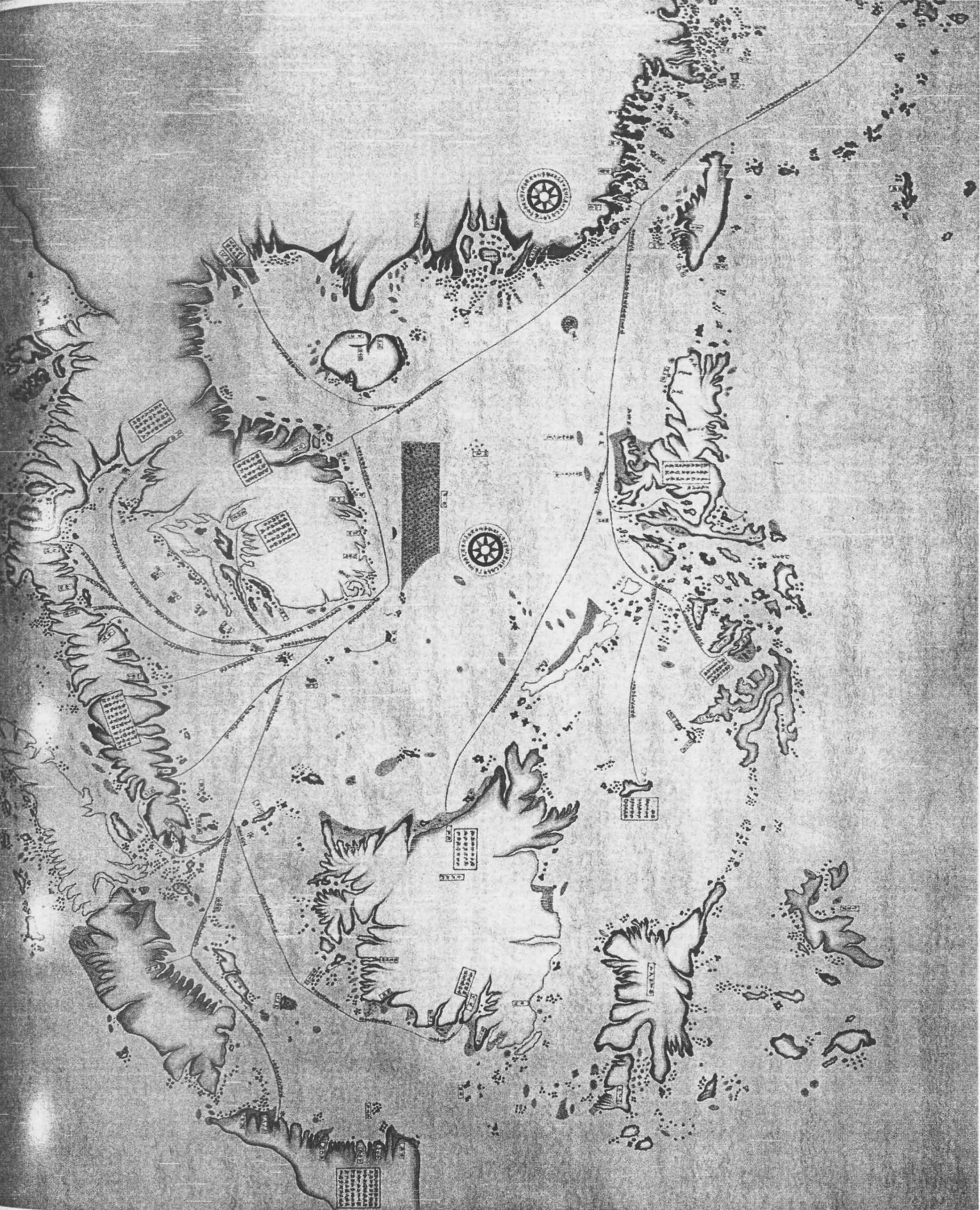
The Map of South and East Ocean Sea Routes was drawn in between 1712-1721 by Qing (Ching) Dynasty Fujian (Fuchien) Province Navy Commander Shi Shibiao, the son of a famous early Qing Dynasty Imperial Officer. This map shows clearly the sea routes, time and decriptions from Chinese coastal ports to Japan, Laos, Vietnam, Indonesia,Brunei, Cambodia and the Phinllipines. In this map, the locations and names of the Southern Sea Islands(Nanhai Zhudao) are very accurate. The map shows clearly Chinese sovereignty over the South China Sea Islands including Nansha Islands, Xisha Islands, Zhongsha Islands and Dongsha Islands.Also note the "long bar area" shown in this map which locates close to the Vietnamese coast, which clearly tells that the so called "Truong Sa" and "Hoang Sa" as shown in the 1838 "Complete Map of Unified Great Nam" are not the Nansha (Spratlys) and Xisha (Paracels) Islands of China at all, but refers to the Pullo Canton near the central Vietnamese coast, which was also once been identified as "dangerous group" and named Paracels before Paracels was used to refer to China's Xisha Islands later in the history.


 I had some other books with told that Paracel is equal-spaced between Vietnamese coast and Hainan, do you need more?