Pakistani Fighter
ELITE MEMBER

- Joined
- Jul 4, 2011
- Messages
- 9,124
- Reaction score
- -5
American or Chinese?satellite positioning
Follow along with the video below to see how to install our site as a web app on your home screen.
Note: This feature may not be available in some browsers.
American or Chinese?satellite positioning


PAKISTAN ARMY To Replace American GPS System With CHINESE BeiDou Global Navigation Satellite System (GNSS) By 2020:
In a bid to end the total reliance on US-based GPS system, PAKISTAN ARMY has decided to replace the American Global Positioning System (GPS) system with the CHINESE BeiDou Global Navigation Satellite System (GNSS) by 2020, which is expected to join the list of credible global satellite navigation system with global coverage by the year of 2020.
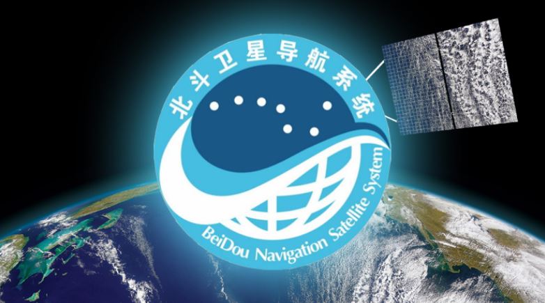
BeiDou Global Navigation Satellite System (GNSS)
It is worth mentioning that PAKISTAN’s All Weather Ally and Iron Brother CHINA is expected to launch the last satellite of its indigenous BeiDou Constellation Navigation System Satellites, which will help its long-term and Strategic Ally PAKISTAN to gain benefit from it.
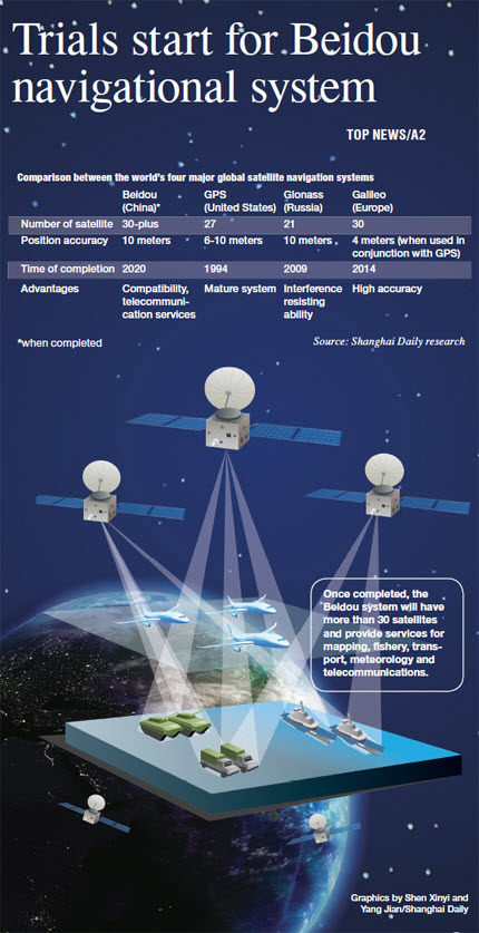
The CHINESE BeiDou Global Navigation Satellite System (GNSS) is the fourth consecutive Global Satellite Based Navigation system after the US-based Global Positioning System (GPS), Russia’s GLONASS and Europe’s Galileo Satellite Navigation System.
Logo of BeiDou Global Navigation Satellite System (GNSS)
In modern day warfare, the overall significance of Global Satellite Navigation system has emerged more than ever before. The reason behind that almost each missile of the world uses some specific kind of global navigation system to reach and destroy its target with pinpoint accuracy. Now, imagine if a country has used a specific global navigation system of a particular country and the country deliberately disables the functionality of the navigation system at a crucial time, then what the military of the country would do in this regard?
According to the Defense Experts, the satellite-based Navigation system plays a crucial role in the modern hybrid warfare environment, as a number of countries have used the different Satellite Navigation System on their Weapons, which the native country can easily disable at its sole discretion.
When PAKISTAN ARMY deployed its troops in Kargil in 1999, the indian military instantly goes to the united states and sought the Global Positioning System Data for the Kargil region to know the positions of PAKISTANI Troops. The US has reportedly denied indian request to share any space-based navigation system with the country.
Apart from using the CHINESE BeiDou Global Navigation Satellite System (GNSS) for military navigation purposes, system can also be used for agricultural purposes as well.
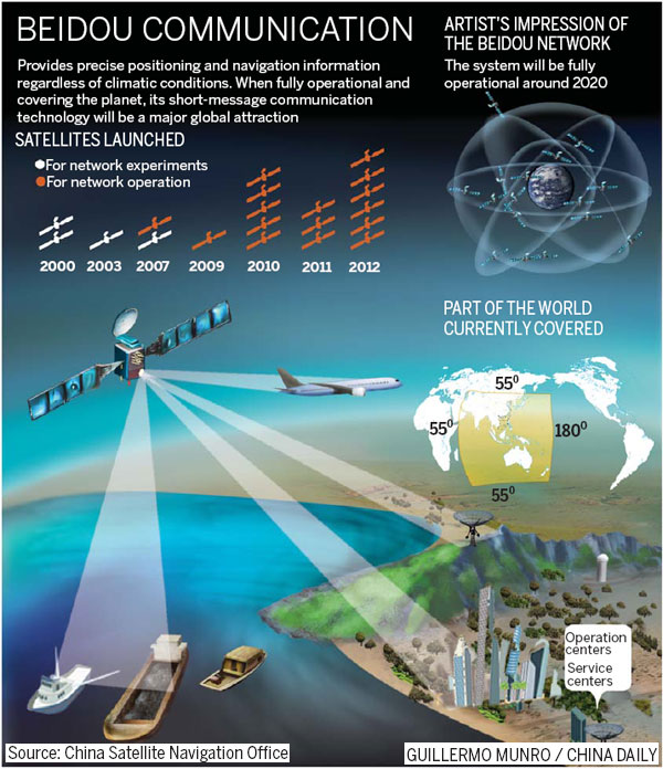
The Satellite Navigation industry of Beijing is expanding considerably and Beijing expects that this industry will easily surpass the whopping 57 Billion USD or 400 Billion Yuan in the current year.
Working Methodology of BeiDou Global Navigation Satellite System (GNSS)
A report prepared by the U.S.-China Economic and Security Review Commission state that CHINESE BeiDou Satellite Navigation System is a state of the art navigation system features pinpoint accuracy of under 8.25 meters, by using the constellation of 35 state of the art satellites. Furthermore, the accuracy can further be improved centimeter level accuracy by using the additional ground stations in the area.
Aspect of BeiDou Global Navigation Satellite System For CHINA:
PAKISTAN’s All Weather Ally and Strategic Partner CHINA has basically used the BeiDou Satellite Navigation System to serve different Strategic purposes, which are as follows:
Prospects of CHINESE BeiDou Global Satellite Navigation System For PAKISTAN ARMY:
- To secure the Critical National Security Requirement by totally ending the reliance in US-based Global Positioning System (GPS)
- To achieve the leverage of International and Domestic prestige, as there are only 4 Global Navigation Satellite Systems (GNSS), which have so far developed in the world
- To build a commercial downstream satellite navigation industry to take advantage of the quickly expanding market
- To cementing CHINA’s status as the leading Space Power in the world
It is worth mentioning that PAKISTAN ARMED FORCES, including the PAKISTAN ARMY, PAKISTAN NAVY and PAKISTAN AIR FORCE have previously heavily relied on US-Based GPS Navigation Satellite System and have installed the American GPS system on all its missiles and strategic weapons.
BeiDou Global Navigation Satellite System (GNSS) Pictorial Image
PAKISTAN being the long-term Strategic Partner and All-Weather Ally of CHINA has enjoyed special privileges, especially in the Defense Sector, which not any country in the world has enjoyed so far.
This is the reason that PAKISTAN’s All Weather Ally CHINA has granted the unrestricted military access to PAKISTAN over BeiDou Global Navigation Satellite System (GNSS) that only the CHINESE PEOPLE’s LIBERATION ARMY (PLA) uses.
As all the missiles are using the US-based GPS system to find their target, so they can be easily be disable by US at the crucial time as US has a long history of betrayal and back-stabbing PAKISTAN at crucial Junctures.
It is important to mention that CHINESE PEOPLE’s LIBERATION ARMY (PLA) has already switched its core Defense and Weapon systems on the indigenously developed BeiDou Global Navigation Satellite System (GNSS).
The CHINESE ARMED FORCES have integrated all the major weaponry on the BeiDou Navigation system as the modern day warfare requires pinpoint accuracy, advanced communication systems and precision-guided weapons. `
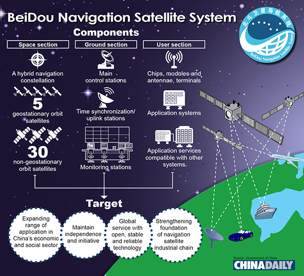
CHINESE Media has stated that the BeiDou Global Navigation Satellite System (GNSS) is quite unique from other Global Navigation Satellite Systems (GNSS) available in the world, because it includes the “Medium Earth Orbit, inclined geosynchronous earth orbit and geostationary earth orbit satellites.”
CHINESE PEOPLE’s LIBERATION ARMY (PLA) has successfully integrated the indigenously developed BeiDou Global Navigation Satellite System (GNSS) on all its weaponry and command system.
PAKISTAN is the first foreign country in the world that has used the CHINESE BeiDou Global Navigation Satellite System and now, more than 30 countries of the world are now using this system, largely in the Asia, Africa and Middle East, including PAKISTAN, Indonesia, Thailand, Russia, Maldives, Kuwait, Uganda, Cambodia and Egypt.
UniStrong Science and Technology Co, a Beijing-headquartered global navigation satellite system has also established a regional satellite navigation system consisting of one processing center and five base stations in Karachi back on May 21, 2014.
The Chief Scientist of UniStrong Science and Technology Shen Jun has stated the company has successfully completed the first stage of PAKISTAN’s geographic positioning network with the network covering in Karachi.
PAKISTAN is also a major and a prime Defense Partner of CHINA and is purchasing state of the art Warship, Submarines and Fighter Jet are also using the CHINESE BeiDou Global Navigation Satellite System (GNSS).
PAKISTAN indigenous and Prime Fighter Jet JF-17 Thunder is also using CHINESE BeiDou Global Navigation System (GNSS) for its combat operations.
Furthermore, PAKISTAN’s indigenously developed RA’AD-II Cruise Missile also reportedly uses the CHINESE BeiDou Global Satellite Navigation System (GNSS), which could easily be seen as an attempt of PAKISTAN MILITARY to end its reliance on US-based Global Positioning System (GPS).
PAKISTAN’s Leading Defense Analyst Lieutenant Genera (r) Talat Masood has said CHINA is CHINA is more dependable and trustworthy ally of PAKISTAN than the United Sates, which has a long history of back-stabbing PAKISTAN on several occasions.
PAKISTAN can become the First foreign country in the world to totally replace all of its weapons and systems from US-based Global System (GPS) to CHINESE BeiDou Global Navigation Satellite System (GNSS). It means that it will also help to end the US monopoly over PAKISTAN Weapons systems, which need precise communication and guidance systems.
BeiDou Satellite System
Referring the CHINESE BeiDou Global Navigation Satellite System (GNSS), the Defense Analyst Lt. General Talat Masood said, “No doubt U.S has advanced technology, but CHINA is catching-up now, which would be helpful for PAKISTAN as well.”
“CHINESE satellite system would reduce PAKISTAN’s reliance on US-owned GPS,” Lt Gen (r) further added.
Reportedly, the decision of PAKISTAN to end its reliance from US GPS to CHINESE BeiDou System has caused serious panic in the united states as if the Military Trials of the BeiDou went successful, so Beijing could offer the same system to other countries, as it would become impossible for the united states to monitor the military activities of such countries.
It seems that the more difficult days and sleepless nights ahead for india as CHINA has allowed unrestricted military access to its indigenous Global Navigations Satellite System.
Top Defense Analysts are suggesting that this is the right move of PAKISTAN according to the essence of present times as the strategic partnership between the US and india is increasing day by day and it would be a grave national security threat to keep trusting US by keeping a blind eye on its past bitter track records.
The leading US-based media outlet New York Times has reported in 2018 as “PAKISTAN is the only country that CHINA has been granted unrestricted access to the system’s military service, allowing more precise guidance for missiles, ship and aircraft.”
The most striking thing is that US-based Global Positioning System (GPS) has 27 satellites in orbit, Russian GLONASS Global Navigation Satellite System has about 21 Satellites in orbit, European Galileo Satellite Positioning System has 30 Satellites, while the CHINESE BeiDou Global Navigation Satellite System (GNSS) has more than 35 Satellites into orbit and this number is expected to grow in future.
.
.
https://www.pakdefense.com/blog/pak...system-by-2020/amp/?__twitter_impression=true


I don't know what our establishment is doing. What are they thinking making blunders like this.
This effectively means we've surrendered to China and weakened our position even more towards China.


Yea sure Mr Expert. The Establishment should come to you for their "strategic decisions".
Nothing wrong with that. I am a citizen of Pakistan and establishment is my servant and should work for what we want and don't want. In an ideal world at least. Unfortunately, Pakistani leaders think the citizens are servants and they're there to just enjoy without any accountability.
Why are you stalking me?
You do realise that all US Equipment still requires GPS?
The Establishment is your 'servant'. Ok.
Our*
I am aware it's theoretical and nothing to do with reality. But responding to your insult and educating you in the process. You don't even know your rights


You an idiot...27 feb was not possible with out Chinese techI don't know what our establishment is doing. What are they thinking making blunders like this.
This effectively means we've surrendered to China and weakened our position even more towards China.
You are 'educating'. No thanks - even my cat knows more than you. LOL.
So once again, the US weapon systems would still require GPS. Pakistan would use a combination of Beidou, GPS , and Local GPS type systems. It is called "Diversification" and certainly NOT what you have misleadingly and blatantly posted here.


Good decision.
No GPS,No Glonass and no other European system. Those countries are full of hypocricy when it comes to India pakistan enmity and during war time they are highly unreliable.
Many Indian defence analysts are losing their sleep over pakistan adopting beidou system and Huawei installing 5g fiber network all over pakistan. That's definitely an edge over India.
Even countries like USA are going to take more time installing 5g all over the country.

Pakistan should invest in regional GPS, that would supplement Chinese. Just in case Chinese decided to play off Pakistan or come under international pressure, Pakistan has a fall back strategy.Lots of misinformation and hearsay in the posts here about how satellite navigation works and how this is an amazing idea and whatnot. I won't go into any details for the sake of saving my time, just going to clear up some misunderstandings:
- GPS is the American system, procured and owned by the US Air Force. It is, first and foremost, military technology. Therefore, any use of it is reliant on American cooperation. For example, during the Yugoslavian war, the GPS service in the entirety of Europe was spoofed to disable their defense systems. This obviously pissed the rest of the Europeans off and encouraged the establishment of an independent European satnav system (Galileo)
- The Chinese system is not much better for us. At any time, China could spoof its systems at will to disable Pakistani defense mechanisms. I like the idea of "diversification" because it means we can play one supplier off the other. However, we have a general overreliance on China for almost everything. That is what we have done with China for decades now.
- Russia has their own system called GLONASS which would be too dumb to even consider
- The European Galileo SatNav system is NOT a military system. It is a commercial system owned and operated by the European Commission, that can also be used for military purposes. This means that no single country can spoof it at will, there would have to be consensus amongst its msnt collaborating nations (Germany, France, UK, etc). Personally, that, to me, would be the safest option to be the base.
Lastly, I want to say on a slight tangent, the state of the Pakistani space program is laughable. We are a a country with long range ballistic missiles which cannot launch a small satellite into Low Earth Orbit, or even build an entire navigation/communications satellite in-country. That truly shows you how short sighted our Military Establishment has been for decades (I don't blame the politicians, they are usually clueless to technology anyway)