What's new

History of Sindh

ghazi52

PDF THINK TANK: ANALYST
Joined
Mar 21, 2007
Messages
101,792
Reaction score
106
Country
Pakistan
Location
United States


Huzaifa.

@MHuzaifaNizam


Accidentally discovered something great today. I was checking out old European maps of South Asia where one referred to the Mughal Indus Valley province as Sindia. Upon research from a book from 1748, I learnt of the Europeans concepts of Sindia and the Sindian sea over Pakistan.


1616348089431.png


1616348114697.png


1616348154069.png


British map from 1816 depicting the region of modern Pakistan under the label of “Sindetic Hindoostan”. [Sindetic Hindoostan or the country of the sinde(Indus) was 1 of the 4 early divisions of South Asia made by the British.] twitter.com/MHuzaifaNizam/…


1616348251748.png


German map from 1848 depicting the region of modern day Pakistan under the label of ‘Induslander’. The map reads “Die Induslander nebst Afghanistan und sud Turkestan” — “The Indus land together with Afghanistan and south Turkestan.”
https://twitter.com/MHuzaifaNizam/status/1344651108334112774/photo/1
 
Mir Muhammad Nasir Khan, the Talpur ruler who fought the Battle of Miani.

1620400252702.png


Mir Nasir Khan Talpur was the last Amir of the land that included Sindh and parts of present-day Balochistan and was one of the most active administrators after the decline of the Mughal Empire.

He made Hyderabad the capital of his empire and constructed two forts in the city known as the Pakka Qilla (Brick Fort) and the Kacha Qilla (Mud Fort) and he also built the Maula Ali Qadam Gah (The footsteps of Ali), a Shia shrine at the center of the city. He was a strong follower of the Sufi tradition. He donated a lot of his personal wealth to the Tomb of Shah Abdul Latif Bhittai at Bhit Shah.

He and his 30,000 forces were defeated by the forces of the British Empire led by Charles Napier at the Battle of Miani. Mir Nasir Khan Talpur's defeat was an ill omen for the last Mughal Emperor Bahadur Shah Zafar.


Mir Nasir Khan Talpur was the last Amir of the land that included Sindh and parts of present-day Balochistan and was one of the most active administrators after the decline of the Mughal Empire.
 
Last edited:
HM King George V Of The United Kingdom With HH Huzur Pur Nur Sarkar-i-Khairpur Mir Sir Faiz Muhammad Khan I Sahib Talpur Of Khairpur (GCIE), On Arrival In Khairpur House, Karachi.

1620402814762.png


Sir Faiz Muhammad Khan I Ruled Over Khairpur From 1894 To 1908, And Is Still Remembered For His Generosity.
 
1621546523227.png


Boat builders at Sukhur, Circa 1890.

Sukkur is an ancient town on the west bank of the Indus, with the town of Rohri on the opposing bank. It is best known today for the Sukkur Barrage nearby, built 1923-32, which controls one of the largest irrigation systems in the world, and as a base from which to visit the archaeological site of Mohenjo Daro, which flourished 5000 years ago as a centre of the Indus Valley Civilisation.

Modern Sukkur, which was developed in the 1840's by Sir Charles Napier after the conquest of Sindh, is an important commercial and industrial city and a centre for trade with Afghanistan. Boat building was an extremely important industry here in the 19th century employing men from all over Pakistan.

The Indus flows from Tibet in the Himalayas to the Arabian Sea, and nomadic boat peoples of the Lower Indus Basin in Sindh used to travel freely up and down the river in their wooden craft, until the barrages contructed across it impeded their movements from the 20th century onward. Called the Mohanas, some of the boat people still live on their boats near Sukkur, although many are forced to live in settlements on the river banks.

Traditional wooden boats are also used as fishing vessels, and while both men and women went out in the boats in the past, women are less visible now due to the paucity of fish caused by over-management of the river and over-fishing.

This photograph is from an album of 91 prints apparently compiled by P. J. Corbett, a PWD engineer involved in irrigation work at the famine relief camp at Shetpal Tank in 1897, and in canal construction in Sindh in the early 1900's.

Photograph of men at work constructing wooden boats at Sukkur in the Sindh province now in Pakistan taken by an unknown photographer in the 1890's.
 
The genome of an ancient Harappan woman from Rakhigarhi was recently published. The study further confirms the absence of Eurasian steppe DNA (Aryan) among ancient Harappans implying that Aryan migrations occured later which many northern South Asians can trace their partial lineage from (mixed with others).

Additionally, contrary to the paper published last year that suggested ancient Harappans were Iranian farmers (pre-Aryan) mixed with South Asian hunter-gatherers, now there is new evidence that this mixing occured before the advent of agriculture in Iran. Therefore, it were the Iranian hunter-gatherers who got mixed with some South Asian hunter-gatherers to eventually form the Harappan Civilization, and its development of agriculture either occured independently or through the transmission of culture from the Fertile Crescent (via trade).

The only problem with this study is that these findings are based on a single person's skeletal remains found in a grave from Rakhigarhi which is located at Harappan Civilization's eastern most periphery. There are pending results from others, and a need to analyze the DNA of excavated skeletal remains from other Harappan sites. The Harappan Civilization was geographically very widespread, so it is very likely that ancient Harappan DNA had regional variations with areas closer to Iran (west) having more Iranian DNA, and the influx of slaves/migrants from its east/south impacting the DNA as well.

Btw, the attached image uses the term Andamese hunter-gatherers instead of South Asian hunter-gatherers or Ancient Ancestoral South Indians (AASI)....it's the same thing.


1622167711038.png
 
“Die Induslander nebst Afghanistan und sud Turkestan” — “The Indus land together with Afghanistan and south Turkestan.

Leave it to the Germans to sniff be unapologetically blunt in their 18 19th century obsession with race.

Classic evangelical Gham and Sham darwinism.

How come this is not anti semitic or anti hemitic?
 
Nagarparkar: Land of History and Architectural Marvels


Nagarparkar

A small town neighboring the Indian border in Sindh. Situated at the foot of the dramatic and mineral-rich Karunjhar hill, the desert is home to centuries-old Jain and Hindu temples, a white-marble mosque, a magical well and thousands of resident snakes!

Nagarparkar Marvels


Born from under the sea, Nagarparkar is a small town situated at the foot of the dramatic and mineral-rich Karunjhar hills, and neighbors the Indian border in Sindh. Surrounded by rocky belts and sand dunes, the desert is home to centuries-old Jain and Hindu temples, a white marble mosque, a magical well, thousands of resident snakes, memorial stones, granite deposits and rare flora and fauna.


It is said that the Karunjhar hills provide 1.25 kg of gold every day in the form of red granite stone, china clay, and honey. An embodiment of remarkable architecture, there are over twelve Jain temples found in the area.

These date back to as far as the 14th century – the era when the Jain architectural expression was at its ultimate – and are now one of the important heritage sites of Pakistan. Some of the notable shrines include; Karoonjar Jain, Virvah Jain, Gori and a cluster of three temples at Bodhesar etc.


56c5af3b5bce1.jpg


The Gori temple in Nagarparkar area of Tharparkar district

These are richly decorated with sculptures and paintings. The carvings on the pillars and entrances of these temples are magnificent for their intricacy. One of these sanctuaries is believed to have been built by a Jain woman and is locally called Poni Daharo.


The walls of these abandoned buildings are geometric steps of marble — a particular style that shows up everywhere from the temple’s steps to the frames carved inside some of its walls and are widely seen among Jain constructions.


591b3f9e0b16037778bb9d68d801b929.jpg


A glimpse into desert life


The canopies at the entrance of these temples are decorated with paintings that represent Jain mythology. It is believed that the frescoes at Gori temple are some of the oldest Jain frescoes in existence.
Unfortunately, not much has been done to conserve these heritage sites and some are merely ruins of what were once considered architectural wonders. Nagarparkar is home to almost 200,000 inhabitants, who mostly belong to modest backgrounds.

The town is majorly inhabited by Hindus, who have historically lived in harmony with the Muslim minority. In fact, the famous temples of the area make it mostly a town of the Hindus and Muslim pilgrims who visit each year to perform religious rituals or attend meals at the local shrines.


Nagarparkar Marvels


Women carrying water in Tharparkar district, Sindh

Bhodesar Mosque

Alongside the pond at the foothill of the Karunjhar lies a beautiful, shining white mosque. This remarkable structure, built entirely with cold and welcoming marble, is said to have been built by Sultan Mehmood Begra, the ruler of Gujarat. An inscription on the mosque lists the year 1505, which is also a reminder of the Jain-inspired architecture at the mosque.


o2bpemyz45e21.jpg


Bhodesar Temples (Jai), Nagarparkar, Built around the 9th century CE by a Jain woman named Poni Daharo


Durga Mata Temple

Found on the Churrio Jabal hill, this historic Hindu sanctuary hosts up to 200,000 pilgrims annually on Shivratri. Visitors bring cremated ashes of their departed beloveds to immerse in the holy water.


Nagarparkar Marvels


Ancient Bhodeser Jain Temple, Nagarparkar, Sindh, Pakistan.

The valuable and multi-coloured hill supporting the temple is mined for its rare and expensive granite, which is posing a serious threat to the foundation of the house of the Hindu goddess, Durga.


1200px-Jagat_22-76.jpg


Marvi’s Well

Located in the Bhalwa village, this well is considered as one of the primary cultural standpoints of the Thar Desert and has now been extended into a cultural center. This complex is a historical reminder of the story of Umar and Marvi. Umar Soomro, a local ruler of the area in the 13th century, fell in love with the beautiful Marvi while she was drawing water from this well.


Nagarparkar Marvels


The story, however, takes a bleak turn where after continuous rejection, King Umar kidnapped the girl and kept her hostage for a year in hopes for her to settle one day.

But after realizing that no number of jewels could waive Marvi’s love for her fiancé back in her town, alas, he had to let her go. Marvi was immortalized because of her strong-will, determined character and her pure love for her homeland. She is remembered today as one of the bravest women in Sindhi history.


Lodging and Logistics

What was once a remote taluka, attended only by Hindu pilgrims, was connected to the rest of the world with a road in 2008, and since then, increasing numbers of visitors are responsible for the lack of upkeep of the prevalent temples. The area is almost two hours away from Mithi, which can be reached by road from Karachi via Mirpurkhas.

Lodging facilities have been almost non-existent in the area, except for a few rest houses that are only open to government employees and their families.

However, in 2017, the Sindh culture and tourism ministry opened the ‘Rooplo Kolhi Resort’ at Nagarparkar, in hopes of promoting tourism in the area.
On the other hand, ones with wandering souls can rent a charpai, a traditional woven bed used in the Indian subcontinent, from any local restaurant or dhaba to spend the night under the starry skies of Thar.
 
Sindh’s population, religion and sect etc. according to 1881 census.


Total population ....... 2,542,976.

Male .........1,387,576
Female .....1,155,400
Muslim .....1,887,204
Hindu ...... 305,079
Sikh ..........126,976
Christian.. 6,082
Parsi......... 1,063
Jew............ 153


1623784531654.png
 
Last edited:
838736_7064804_Printing-Blocks_magazine.jpg


Block printing in the subcontinent originally has its roots in the Indus Valley civilisation, where the famous Sindhi ajrak was also handcrafted and dyed. While the essence of this technique is over 4000 years old, with time the process has evolved and has been brought into commercial production. The dyes, variety of fabrics, the patterns and the designs have all progressed according to current fashion trends, but the elements of wooden block carvings, which are delicately and carefully hand-stamped by local artisans, more or less remain in practice even today.

Block prints are a timeless trend and favour the ethos of what we call slow and sustainable fashion. A block printed tunic you buy one year is unlikely to go out of fashion the next year, or the next. Moreover, handicrafts like block prints fall well in line with responsible fashion; communities of artisans in rural areas do benefit from the business that comes in and that’s just the core of its strength.
 
Tomb of Mian Yar Muhammad kalhoro who was first Kalhoro ruler of Sindh, who after wandering about northern Sindh and Baluchistan upon warlike expedition's,

1626029513724.png


Finally settled down at Khudabad, in Dadu of Sindh Pakistan. He died in 1718 A.D. He built tomb for himself before death.
 
About 4200 years ago, zebu (humped bull) of Indus Valley of Pakistan origin, was found in abundance in Fertile Crescent, Egypt & Mesopotamia etc.

Descendants of cattle of ancient Indus Valley of Pakistan are herded in each continental tropics region today since over 4000 years.

1630334989507.png


1630335012481.png
 
Thar Desert boasts rich architecture

Thar Desert boasts rich architecture

https://nation.com.pk/NewsSource/haber
Anadolu
6:06 PM | September 13, 2021


Pakistan's Thar Desert, otherwise famous for its frequent famine spells and treacherous weather, boasts a spectacular architectural treasure which authorities are finally trying to preserve.

Surrounded by crowded streets, in the midst of Umerkot city in the Sindh province, stands a vast fort described as a transitional point of the Mughal dynasty that ruled India for over three centuries.

Vendors repeatedly make loud chants about their wares to attract buyers at a bustling bazaar just a few meters away from the fort entrance.

Scores of auto-rickshaws are also parked in a long line near the outer wall of the fort, turning it into a permanent and illegal transport terminal.

Located some 60 kilometers (37 miles) from the Indian border, the 11th-century citadel is the birthplace of Akbar, the third emperor of the Mughal dynasty, who was born in 1542, when his father was on the run after being defeated by Afghan King Sher Shah Suri.

On his way to Iran, Humayun was given refuge by the Hindu Rajput ruler of Umerkot, Rana Parshad Sodha, until the defeated emperor regained his strength and raised an army to snatch his kingdom from Suri’s successors just four years after Akbar's birth.

According to another account, Akbar was born in the middle of a jungle located five kilometers (around three miles) from the fort, where a monument has been constructed.

Once crumbling due to the ravages of time and years of neglect, Umerkot Qila (fort) -- as it is locally known -- is currently in a relatively presentable state following its restoration by the heritage authorities that began in 2016.

A newly repaired wide staircase made of burnt red bricks leads to a high platform overlooking the Umerkot city.

The platform is dotted with seven discarded brass canons in a circle with a green and white Pakistani flag fluttering in the middle.

The site was also used for executions by the British army following the capture of Sindh in 1843.

The fortification wall, as high as 45 feet, is made of burnt bricks.

The fort houses a jail, guest house, and museum.

Surrounded by heaps of broken bricks, the jail and guest house, constructed during the British colonial era, are currently in ruins.

But the museum is well-maintained and has long been the central attraction for visitors.
It contains ancient manuscripts, coins, paintings, specimens of calligraphy, royal documents, jewelry, Mughal-era arms, and Jain and Hindu sculptures that shed light on different periods of history.

“No doubt, there has been some improvement in the otherwise crumbling condition of this historic fort during the past few years," said Noor Ahmed Janjhi, who often writes on the history and architecture.

He noted that much more is needed, however, to restore the fort to its original state, including the removal of illegal settlements.

A part of the museum has been dedicated to depicting the popular Sindhi folktale Umar Marvi about Marvi Maraich, a girl from Thar who resists the overtures of the powerful Soomro King Umar and the temptation to live in his palace as a queen, preferring to be in a simple rural environment with her own village folk.

Inside a large room, life-size statues of Marvi, Umar, and his maidservant are erected.

Attired in a swanky gown and sporting a turban, Umar is shown asking Marvi for her hand as his maidservant is seen holding jewelry in a piece of cloth. The jewelry is meant for Marvi, who, however, sitting on the floor, is rejecting the king's proposal with a somber face.

Umerkot is one of two Pakistani cities where Hindus make up nearly half of the local population.

Both Hindus and Muslims have conflicting claims to Umerkot or Amarkot fort and the city itself.

According to one account, the city and the fort were constructed by Maharaja Amar Singh, who came to power in the middle of the 13th century. Some historians say the fort was built by King Umar, the founder of the Soomro dynasty, in the middle of the 11th century.

The fort was later held by different rulers until 1843, when the British army captured Sindh. After the partition of India in 1947, the fort was taken over by the Pakistani government.

No matter who built the fort, visitors recall the tale of Marvi, who was incarcerated in the fort for refusing the king's proposal.

Often referred to as "Marvi of Malir" (prosperous and green in the Thari language), Marvi was immortalized by Shah Abdul Latif Bhittai, a mystic Sufi saint and poet, in his celebrated poetic compendium Shah Jo Risalo, depicting her as a symbol of courage and patriotism.

Shah Latif also named one of the seven musical notes he invented after Marvi, commonly known as "Sur Marvi."

Marvi later returned to her home village, Bhalwa, untouched.

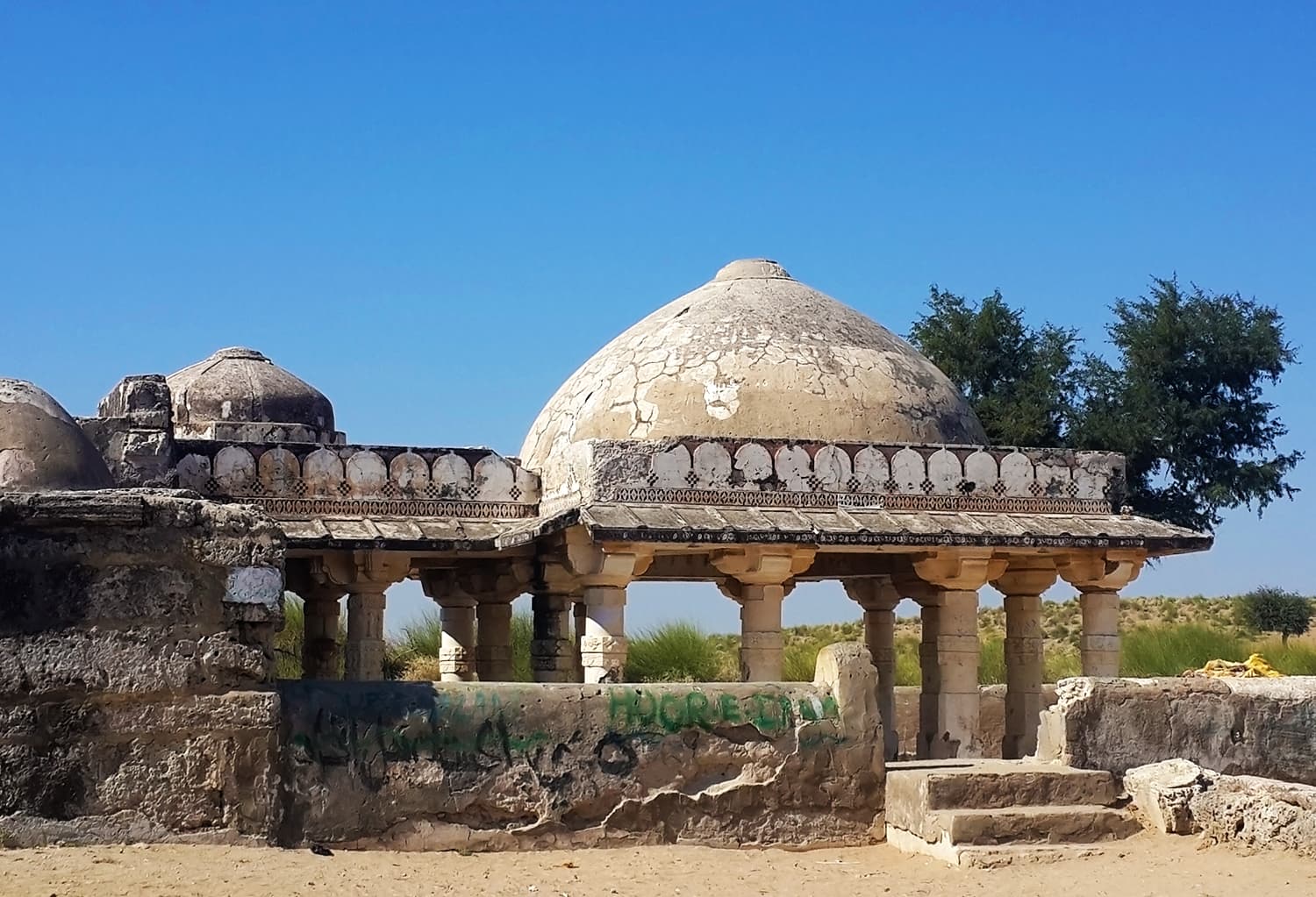
The Akbar monument, a modern brick-built small-domed pavilion situated on a small piece of land on the eastern outskirt of Umerkot, is erected to honor the Mughal emperor who ruled India for 49 years.

Encompassed by vegetation, which is the result of recent rains on the one side and Neem and Sidr trees on the other, the doorless pavilion is built with baked red bricks. The dome is slightly fading due to sunshine and rains.

According to a plaque outside the monument, Akbar was born at this place, which was once a part of the thick forest.

Supporting the contention, Janjhi, who has authored the book Tharparkar: Land of Colour, Contrast and Culture, said Akbar was born at this site, which at that time was part of the ancient Umerkot fort.

The existing structure of the fort, he said, is the result of an expansion by the Kalhoro dynasty in the 18th century.

A couple of stone benches have been set up under the tall Neem trees in a small lawn located next to the monument, allowing visitors to take a rest in the midday broiling sun.

Standing in the middle of a sprawling green swathe, the monument is as simple as many others. But it reminds visitors about one of the most illustrious rulers of the Mughal dynasty, also known as Akbar the Great.

"Umerkot and the Mughal dynasty had had an inseparable connection. It was Umerkot that actually saved the long-running dynasty. Otherwise, it would have been restricted to Humayun only," Janjhi said.

"It was Umerkot that had provided refuge and opportunity to Humayun to recapture his lost empire," he went on to argue, adding that Humayun had first sought refuge from the ruler of the Jodhpur state, which was rejected.
 
1631660951557.png


Archaeological evidence from 2000 year old Debal or Bhambore city, Pakistan revealed that it was a major harbour-town & market & made luxury goods for exports through sea & land routes. Experts also found agricultural bases served by irrigation canals & barrages outside the city.
 
Ships with masts were used during 5000 years old Indus Civilisation city of Harappa in Pakistan. Scylax of Caryanda carried out reconnaissance using ships on Indus around 500 BC. Nearchus led Greek flotilla along Indus in 325 BC. Mughal era ships traded from Lahore-Multan-Thatta.

Some of the ancient capitals of Sindh Province of Pakistan as mentioned in "The Land of the Five Rivers and Sindh" by David Ross (1883):

Aror, or Alor, near the present town of Rohri
Multan Mansura
Thatta
Sehwan (earlier Samanager)
Shikarpur
Hyderabad
Mirpur
Khairpur
 
Kashikari in Hala of Sindh Pakistan, is a decorative handcraft.

Kashi means ceramics and kari means work. This is an ancient #art and these artists are keeping it alive generation to generation. Great !


1643581650743.png


1643581679355.png
 

Latest posts

Back
Top Bottom