What's new

China Space Military:Recon, Satcom, Navi, ASAT/BMD, Orbital Vehicle, SLV, etc.

长征五号乙火箭整流罩第二次分离试验成功
ht43.jpg

时间:[2015-06-12]
20150612170432ff9f545fb3.JPG

长征五号乙火箭整流罩第二次分试验 摄影:孙浩
近日,长征五号乙火箭整流罩第二次分离试验取得圆满成功。此次试验成功标志着长征五号乙火箭整流罩结构符合设计要求,整流罩系统设计可靠,为后续首飞奠定了基础。

Second test successfully completed for separation of CZ-5B payload fairing.
 
Cooperative deals inked to expand use of China's BeiDou navigation system
June 16, 2015

FOREIGN201506160804000455761255185.jpg

(File Photo)

The strategic alliance of Asia-location services and smart city industrial technology innovation signed cooperative deals to promote the use of BeiDou Navigation Satellite System (BDS) with universities and companies from Laos, Myanmar, Indonesia, Bangladesh, Sri Lanka and Maldives at the Third China-ASEAN Expo on June 13, according to China News Service.

It indicates that China, as the third country with its self-developed satellite navigation system after the United States and Russia, begins to provide service in South Asian and Southeast Asian countries.

In addition to car navigation and information service and vehicle monitoring and management, Satellite navigation systems can also be used in many areas such as geological disaster monitoring and early warning, cross-border logistics, tourism, and ecological protection.
 
China should develop some device that it will receive Beidou position and it will modulate fake GPS Navstar signal in order to assure the compatibility with Beidou in any device made for GPS-Navstar.

And I add, Chinese government should broadcast a second Beidou signal over China territory with the same frequencies, and protocol that L1 & L2 GPS-Navstar. :D
 
New antenna to make spaceship landing safer
Last Updated: Sunday, June 21, 2015 - 17:46

New York: There's a new way now to maintain communication with spacecraft -- sometimes lost for several moments -- as they re-enter the atmosphere.


"The key lies in tweaking with the antenna," the researchers said.

Even routine communication blackouts with a returning spacecraft can create moments of anxiety as there is no way to know or control the location and state of the spacecraft from the ground.

"When a re-entry vehicle is unable to be connected, the only thing you can do is pray for it," said Xiaotian Gao, a physicist at the Harbin Institute of Technology in China.

Gao and his colleague Binhao Jiang have proposed a new way to maintain communication with spacecraft as they re-enter the atmosphere.

Communication blackouts with hypersonic vehicles occur because as the craft zips along at more than five times the speed of sound, an envelope of hot ionised air -- called a plasma sheath -- surrounds it.

This plasma sheath will reflect electromagnetic signals under most conditions, cutting off connection with anything outside of the vehicle.

However, under certain special conditions, a plasma sheath can actually enhance the radiation from a communication antenna.

Gao and his colleagues reasoned that it would be possible to replicate these special conditions in ordinary hypersonic flight by redesigning the antenna.

The researchers first analysed earlier experiments and found that the special signal enhancement could be explained by a resonance, or matched electromagnetic oscillations, between the plasma sheath and the surrounding air.

They propose adding a "matched layer" to ordinary communication antennas to create the desired resonant conditions during normal hypersonic flight.

The matched layer works because it acts as like a capacitor -- a type of electrical energy storage unit -- in the antenna circuit, Gao explained.

The plasma sheath, on the other hand, acts like an inductor, which resists changes in an electric current passing through it. When a capacitor and an inductor are paired together, they can form a resonant circuit.

"Once the resonance is reached, the energy can be exchanged between them steadily and without any loss, like real capacitance and inductance do in a circuit," Gao said.

"As a result, the electromagnetic radiation can propagate through the matched layer and the plasma sheath like they do not exist," he said.

For the resonance to work, the thickness of the matched layer and the plasma sheath must be smaller than the wavelength of the electromagnetic waves used to communicate, so the approach would be ineffective if the antenna frequency were too high, Gao said.

The approach might also be applied to other hypersonic vehicles such as futuristic military planes and ballistic missiles, researchers said.

The findings were published in the Journal of Applied Physics.
 
China's super 'eye' to speed up space rendezvous

Chinese space experts have developed the world's most sensitive "eye" that enables the autonomous rendezvous and docking of two spacecraft -- flying eight times faster than bullets -- more efficiently and safely.

The "eye" is China's newly developed third-generation rendezvous and docking CCD optical imaging sensor. It will be used on China's second orbiting space lab, Tiangong-2, the Chang'e-5 lunar probe and the permanent manned space station, according to China Academy of Space Technology (CAST).

China plans to launch Tiangong-2 in 2016, and send Chang'e-5 to collect samples from the moon and return to earth around 2017. It also aims to put a permanent manned space station into service around 2022.

"Good 'eyesight' is crucial for one spacecraft chasing another for hundreds of thousands of kilometers to achieve a perfect rendezvous and docking -- it's like threading the needle," says Gong Dezhu, a CAST designer who worked on the CCD optical imaging sensor.

"The last 150 meters between the two spacecraft is the most critical moment. A slight deviation during docking might lead to a disaster like the one caused by Mann, the main antagonist in the movie Interstellar," Gong says.

Compared with the CCD optical imaging sensor used in the docking of Tiangong-1 and the Shenzhou spacecraft, the new "eye" can see clearer under direct sunlight, which will greatly improve safety. The window period of the docking process will be twice the length, Gong says.

"And the reaction time between the 'eye' capturing the first sight of its target and recognizing it has been shortened from 10 seconds to less than one second," Gong says.

The sensor's weight and power consumption is only half that of comparable products internationally, says Gong.

Such "eyes" can also be used on mechanical arms, and for refueling and repairing of spacecraft, as well as aerial refueling and docking of underwater vehicles, experts say.
 
China's Beidou navigation system more resistant to jamming
(Xinhua) Updated: 2015-06-25 16:38

BEIJING -- China has made breakthroughs in the anti-jamming capability of its Beidou satellite navigation system (BDS), the People's Liberation Army (PLA) Daily said Thursday.

The new technology, developed by Wang Feixue and his team from the National University of Defense Technology, has made the satellites 1,000 times more secure, the newspaper said.

In March, China launched the 17th BDS satellite, the first step in expanding the regional system to a global one.

The first BDS satellite was launched in 2000 to provide an alternative to foreign satellite navigation systems. In December 2012, the system began to provide positioning, navigation, timing and short message services to China and some parts of the Asia Pacific.

The BDS global network will have 35 satellites, five of which will be in geostationary orbit. The complete network should be installed by 2020.
 
Scientist and his 300-strong team have their eyes on global satellite coverage by 2020

Wang Feixue (second right) discusses with team members at the Center for Satellite Navigation and Positioning Technology of the National University of Defense Technology in Changsha, Hunan province, on May 26. The center undertakes most of Beidou system's research and development.


For the past 20 years, Wang Feixue and his team have been working on China's Beidou Navigation Satellite System. Now the pace is being stepped up to "lay out the stars" and form a constellation of satellites orbiting the Earth.

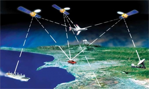
On March 30, the Beidou system sent its first satellite into orbit, marking the first stage of its upgrade from a regional service to global coverage by 2020.

Wang, 44, heads the Center for Satellite Navigation and Positioning Technology at the National University of Defense Technology in Changsha, Hunan province. The 300-strong research team, with an average age below 30, conducts most of the Beidou system's research and development.

"The Beidou global system will focus on improving navigation precision and expanding its application in the Asia-Pacific region," Wang said.

"Because the profitable period for the second generation of satellite navigation systems has passed, further industrial breakthroughs will depend on innovation of the application model and progress of the system," he added.

China will launch four more Beidou network satellites and build seven receiving stations nationwide by the end of this year. The system will have 35 satellites, five of them in geostationary orbit, and achieve higher accuracy by being able to focus to within 1.5 meters of a given point rather than the present 10 meters by 2020.

Wang said some of Beidou's unique technological features, such as the short text messaging service, will find greater markets in the Asia-Pacific region. Compared with the expensive satellite phone service, Beidou's text messaging is free of charge and allows users to send up to 60 Chinese characters.

"The short messaging service was planned to be a byproduct, but it has surprisingly become one of Beidou's most popular functions. It not only shows where you are but also lets others know where you are through communication," he said.

Beidou's short message service first attracted public attention during the rescue work after a magnitude-8.0 earthquake in Wenchuan, Sichuan province, in 2008.

"When power was cut off in the disaster area, Beidou still managed to send back signals to guide rescue teams," Wang said.

"It not only illustrated Beidou's powerful functions at a difficult time and in difficult terrain but also reminded people of Beidou's significance as part of China's information infrastructure," he added.

Wang joined the Beidou project in 1995, as a doctoral student at the National University of Defense Technology. At that time, development of the system had stagnated for almost a decade because scientists could not overcome a technological bottleneck on signal acquisition.

Wang sensed that a potential answer to that bottleneck lay in the burgeoning digital technology.

With his classmate Ou Gang, who is now a professor at the university and senior researcher of the Beidou project, Wang devoted his time to an all-digitalized signal acquisition solution that stumped many of the country's top scientists.

Three years later, hypothesis was turned into reality with the aid of one computer and funding of $6,000. All of Chinese academia was stunned.

"Many said it was a miracle that such young students had achieved a remarkable breakthrough because it was the first time that digital technology had been applied to China's aerospace industry," Ou said.


d4bed9d6cb4016f6ed9805.jpg
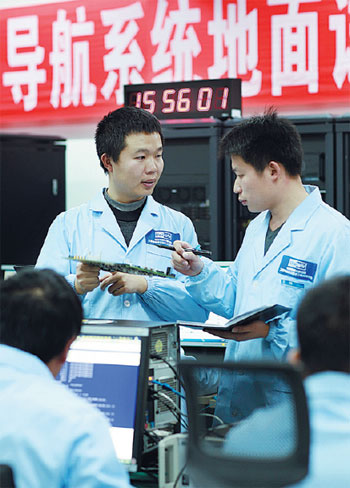
Scientists at the center prepare for the launch of the first satellite of the Beidou global system in January. Photos provided to China Daily

In late 2007, a second-generation Beidou satellite lost contact with its control center due to complicated electromagnetic interference. If the problem remained unresolved for more than three months, it would not only turn the satellite into "space junk" but also delay the launch of subsequent satellites.

Industry experts came up with two solutions. The first involved changing to another signal frequency to avoid the interference, while the second required installing stronger anti-interference shields.

"It is technically easy to implement the first method, but changing the signal frequency means the waste of previously launched satellites and the potential for future interference," Wang said.

At such a critical juncture, tremendous pressure fell on Wang and his team to come up with the remedy. After three months of sleepless nights, he once again succeeded in tackling the problem by enhancing the anti-interference capability a thousandfold.

"As one of the Beidou system's leading scientists, Wang spends on average 200 days each year on business trips and at testing grounds. His hardworking spirit has inspired every member on the Beidou team," Ou said.

China is the third country to develop its own satellite navigation system, following the United States' GPS and Russia's GLONASS. It began providing positioning, navigation, timing and short messaging services to civilian users in China and neighboring countries in the Asia-Pacific region toward the end of 2012.

Ran Chengqi, director of the China Satellite Navigation Office, which oversees the Beidou project, said China is cooperating on satellite navigation with surrounding countries, such as Australia, Indonesia, Pakistan and Singapore.

"We are helping some countries in Southeast and Southern Asia plan for their ground applications of the Beidou system and are building infrastructure so they can better use the system," Ran said.

According to Wang, the next challenge for Beidou is to integrate into the large civilian market, while striving to achieve new technical advances to the system, such as real-time and high-precision positioning technology.

"Competition at the level of civilian use is fierce," Wang said. "GPS has already taken up a large proportion of the market. A country will have to rely on its strong industrial capability to compete in this application area.

"Fortunately, China has a strong industrial system. We are working closely with microchip providers like Huawei to further integrate communication and navigation. Hopefully, we will enter the civilian market within a year or two."
 
The 300-strong research team, with an average age below 30。。。

The same can be said about other teams,such as those developing the J-20、HGV、space lab etc。
 
China's Beidou navigation system more resistant to jamming

BEIJING - China has made breakthroughs in the anti-jamming capability of its Beidou satellite navigation system (BDS), the People's Liberation Army (PLA) Daily said Thursday.

The new technology, developed by Wang Feixue and his team from the National University of Defense Technology, has made the satellites 1,000 times more secure, the newspaper said.

In March, China launched the 17th BDS satellite, the first step in expanding the regional system to a global one.

The first BDS satellite was launched in 2000 to provide an alternative to foreign satellite navigation systems. In December 2012, the system began to provide positioning, navigation, timing and short message services to China and some parts of the Asia Pacific.

The BDS global network will have 35 satellites, five of which will be in geostationary orbit. The complete network should be installed by 2020.
 
我国今天下午成功发射高分八号卫星
2015年06月26日15:05 来源:人民网-科技频道

人民网北京6月26日电(赵竹青)今天14时22分,高分八号卫星在我国太原卫星发射中心成功发射升空,卫星顺利进入预定轨道。

高分八号卫星是高分辨率对地观测系统国家科技重大专项安排的光学遥感卫星,主要应用于国土普查、城市规划、土地确权、路网设计、农作物估产和防灾减灾等领 域,可为“一带一路”战略实施等提供信息保障。高分八号卫星和执行此次发射任务的长征四号乙运载火箭由中国航天科技集团公司负责研制。这是长征系列运载火 箭的第205次飞行。

(责编:赵竹青、马丽)

On today, 26 of July, 14 hr 22 min, China successfully launched Gaofen-8 earth observation satellite into orbit.

It is an optical remote sensing satellites, mainly used in land surveying, urban planning, land ownership survey, road network design, crop yield estimate and disaster prevention/reduction and other fields. It can also help in providing information for the implementation of the "One belt one road" strategic project.

This is the 205th launch of the Long March series of rocket (LM-4B).
 
Last edited:
1435587784114928.jpg

近日,长征七号火箭遥一箭首个助推氧箱完成生产,并通过各项检测和试验,顺利下架。目前已抵达天津厂区开展总装。
The first liquid oxygen tank for CZ-7 booster had been transported to Tianjin for assembly.
 
China's Beidou navigation system to track flights

Exhibitors at Xinjiang International Exhibition Center check Beidou Navigation Satellite System terminals on Tuesday. [Photo/China Daily]


The Civil Aviation Administration of China (CAAC) said the BDS will be tested on general aviation first before it is used to monitor passenger or cargo flights.

The BDS, which boasts navigation, positioning and short message services, is able to trace aircrafts and aid search and rescue operations.

"We will first collect data and gather experience in general aviation and then gradually apply the BDS to transport aviation," said Wu Chengchang, safety chief of the CAAC at a recent seminar on BDS application in civil aviation.

China launched the first BDS satellite in 2000 to provide an alternative to foreign navigation systems. The country aimed to launch a total of 35 such orbiters and complete the global network by 2020.

The BDS services currently cover the Asia Pacific and will be expanded to the whole globe by its completion.
 
Chang'e 4 is the backup of Chang'e 3.
But since the Chang'e 3 mission is deem a success, Chang'e 4 would be re-task with different mission.
The following is a proposal made by China Space Agency to European Space Agency for cooperation.
In that proposal, the Chang'e 4 mission plan was revealed to be soft landing, roving mission on the far-side of the moon !

******
Preliminary Suggestions for International Cooperation on Chang'E-4 Lunar Probe
Xu Y. (China)

http://www.unoosa.org/pdf/pres/copuos2015/copuos2015tech08E.pdf

1436952481474394.jpg

1436952447114198.jpg

1436952447286400.jpg

An Introduction of Chang’E-4 Probe

  • Probe(Lander,Rover)+ Relay Statellite
  • Soft-landing on lunar farside
  • Landing and roving exploration
  • Will be launched between 2018 and 2019

Engineering objectives are as follow.
  • To realize the first soft landing on the lunar farside and perform exploration in human history.
  • To demonstrate technologies of lunar data relay, landing and roving on complicated terrains of the lunar farside, and lunar night power generation;
  • To perform further detailed survey on lunar environment in-order to lay a foundation for subsequent lunar exploration mission.
Tentative Scientific objectives are as follow.
  • To study lunar surface dust features and its formation mechanism;
  • To perform in-situ measurement of lunar surface residual magnetism and study its interaction with solar wind;
  • To study lunar surface temperature and particle radiation environment;
  • To perform lunar surface topology and material composition analysis, shallow-layer structure survey and study;
  • To explore and study lunar interior structure of spheres;
  • To perform lunar based VLF astronomical observation and study.
 

Back
Top Bottom