ghazi52
PDF THINK TANK: ANALYST

- Joined
- Mar 21, 2007
- Messages
- 102,570
- Reaction score
- 106
- Country

- Location

Partition Of Punjab in 1947
Tariq Amir
There are some events in history that always have fascinated me. One of them is the independence and partition of India in 1947. Besides two world wars, it can be counted among the most important events of the twentieth century. This event gave independence to India and eventually three independent countries emerged.
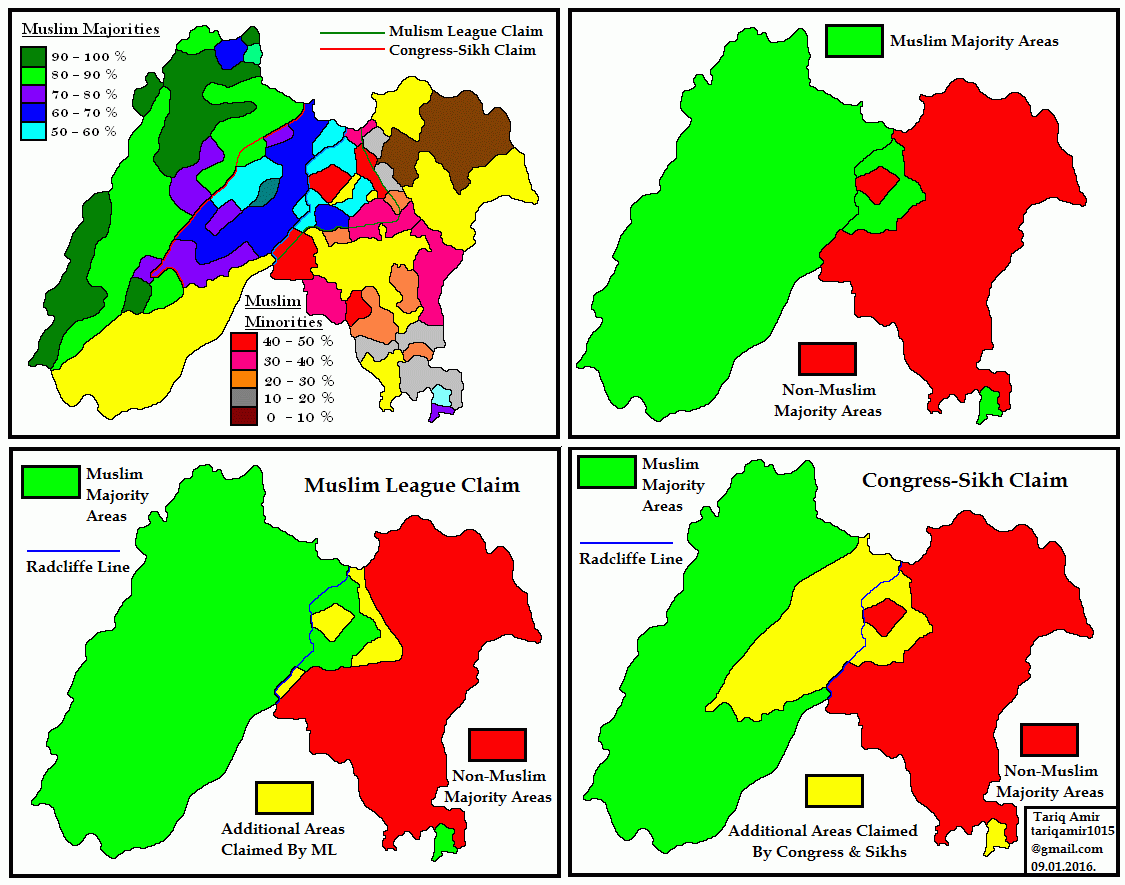
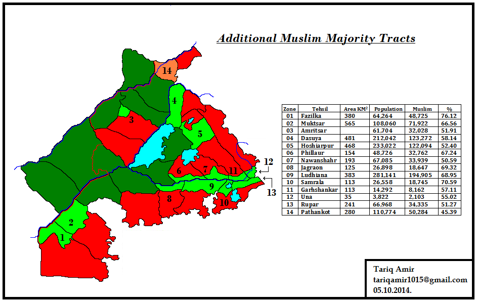
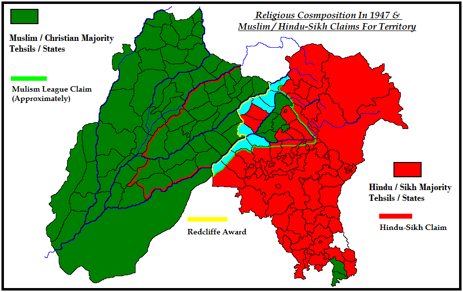
Independence of India was not a simple affair, because it also involved partition of the country. When it came to partition it was actually the partition of two provinces Bengal and Punjab. I first developed my interest in this subject in late 1980s when I was in school and studied in the books of social studies and Pakistan studies about this issue. It was claimed that during the partition in 1947, the last viceroy Mountbatten conspired against Pakistan and influenced Radcliffe to award an unfair decision against Pakistan. But there were no details that exactly how much area according to this claim, was awarded to India unfairly. In the coming years I tried to find the answers but that proved to be a difficult task. First of all there were no maps to be found, and there was no census data as well. However, I kept on searching for more than two decades and finally found most of the pieces of this jigsaw puzzle.
My aim is not to stir a controversy or to forward a claim on any "lost" territory. It is just an academic exercise of a student of history. That is why I have tried to stick to just facts, whether census figures or geographical. I do not claim that these are perfect maps, by a trained cartographer. I made them with the help of dozens of maps I found on internet and books, with the simple tools of MS Paint. But they give a reasonably fair idea and picture of the demographics of Punjab in 1947. All the readers are most welcome to point out inaccuracies or suggest improvements.
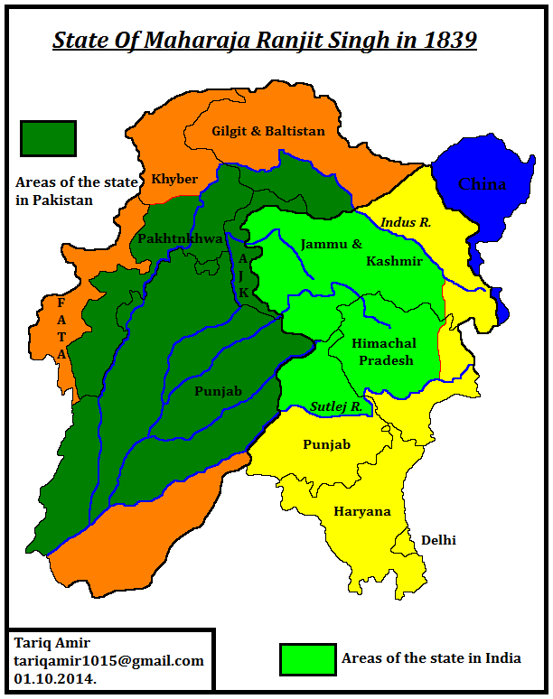
Before moving to my subject I would like to give a historical background of the modern political boundaries of Punjab. After the disintegration of the Mughal Empire, Sikh power rapidly rose in central and eastern Punjab in late 1750s. By 1763 they even captured Lahore the capital and the most important city of Punjab. For the next four decades chaos reigned supreme as the whole province became divided among dozens of petty Sikh and Muslim warlords and chieftains. Out of this situation Ranjit Singh of Gujranwala rose rapidly and captured Lahore in 1799. And by the time he died in 1839, he had conquered the whole of Punjab west of Sutlej River, which included the Bist Doab, all of present day Pakistani Punjab (except Bahawalpur division), most of the Khyber Pakhtunkhwa and the Kashmir valley.

The above map show the boundaries of the State of Maharaja Ranjit Singh in dark and light green colours. The areas marked with dark green lie in Pakistan, while areas in light green lie in present day India.
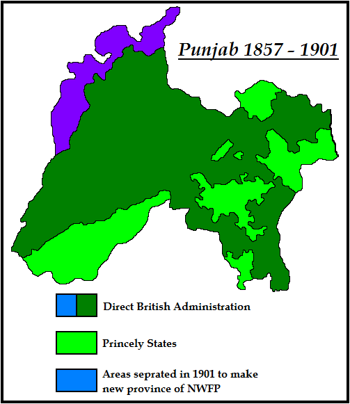
At the death of Maharaja Ranjit Singh the Sikh state of Punjab became politically unstable. The British were as usual waiting for such an opportunity and after many hard fought battles in two wars, finally conquered Punjab in 1849, the last independent state in India.From 1849 onward Punjab became a province of British India. In 1857 a mutiny break out in native regiments of the army of East India Company and soon spread over a large area. It was suppressed with great difficulty and much bloodshed. After the end of the mutiny, the British government assumed the direct control of India and annexed Delhi city and other districts between Jamuna and Sutlej to Punjab. This situation remained until 1901, when districts west of Indus river were carved out of Punjab to make a new province, which was named as North Western Frontier Province or NWFP.

The above map shows the boundaries of Punjab, after the annexation of Delhi and surrounding districts until the establishment of NWFP as a separate province in 1901.
After the establishment of NWFP in 1901, the next change in the boundaries of Punjab came in 1911, when the government of the British India, decided to move the capital from Calcutta to Delhi. After the shift of capital, former district of Delhi was separated from Punjab. Since then Delhi has remained a federally administered area.
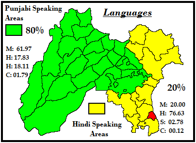
As mentioned above after the mutiny a large area west of Jamuna river was annexed to Punjab. But most of this area was not inhabited by Punjabis. In fact most of this area was inhabited by people who speak a dialect of Hindi, called Haryanvi. Almost 80% of the people living in the province of Punjab spoke different dialects of Punjabi, while rest of them a dialect of Hindi, called Haryanvi.

The above match shows the linguistic division of Punjab. The red area is New Delhi, separated from Punjab in 1911 and declared as the new capital of British India.
India during the British Raj, administratively was a very complicated place. Besides 11 clumsily formed provinces, it had about 565 princely states. Some of them were quite large, but many were so small that it was difficult to represent them even on a very large scale map. Biggest of these was Hyderabad with an area of 214,187 sq. km. But almost 200 states had an area of less than 25 sq. Km. Together these states covered approximately one third of the total area of India and housed one fourth of the total population. If that was not enough many of these were divided into several non contiguous tracts of lands. British Raj controlled these states as the Paramount Power, through its officers called residents.

The above map shows the provinces of British India and also the areas covered by the Princely States. In addition to that it also shows the religious demographics of India.
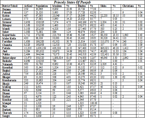
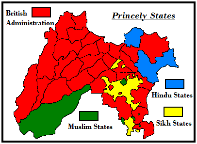
Punjab province was no exception in this regard. It also contained 34 princely states, besides the areas directly administered by the British.

The above map shows the location of British Administered districts and the Princely States, also depicting the religion of the rulers of the states.

Tariq Amir
There are some events in history that always have fascinated me. One of them is the independence and partition of India in 1947. Besides two world wars, it can be counted among the most important events of the twentieth century. This event gave independence to India and eventually three independent countries emerged.
Independence of India was not a simple affair, because it also involved partition of the country. When it came to partition it was actually the partition of two provinces Bengal and Punjab. I first developed my interest in this subject in late 1980s when I was in school and studied in the books of social studies and Pakistan studies about this issue. It was claimed that during the partition in 1947, the last viceroy Mountbatten conspired against Pakistan and influenced Radcliffe to award an unfair decision against Pakistan. But there were no details that exactly how much area according to this claim, was awarded to India unfairly. In the coming years I tried to find the answers but that proved to be a difficult task. First of all there were no maps to be found, and there was no census data as well. However, I kept on searching for more than two decades and finally found most of the pieces of this jigsaw puzzle.
My aim is not to stir a controversy or to forward a claim on any "lost" territory. It is just an academic exercise of a student of history. That is why I have tried to stick to just facts, whether census figures or geographical. I do not claim that these are perfect maps, by a trained cartographer. I made them with the help of dozens of maps I found on internet and books, with the simple tools of MS Paint. But they give a reasonably fair idea and picture of the demographics of Punjab in 1947. All the readers are most welcome to point out inaccuracies or suggest improvements.
Before moving to my subject I would like to give a historical background of the modern political boundaries of Punjab. After the disintegration of the Mughal Empire, Sikh power rapidly rose in central and eastern Punjab in late 1750s. By 1763 they even captured Lahore the capital and the most important city of Punjab. For the next four decades chaos reigned supreme as the whole province became divided among dozens of petty Sikh and Muslim warlords and chieftains. Out of this situation Ranjit Singh of Gujranwala rose rapidly and captured Lahore in 1799. And by the time he died in 1839, he had conquered the whole of Punjab west of Sutlej River, which included the Bist Doab, all of present day Pakistani Punjab (except Bahawalpur division), most of the Khyber Pakhtunkhwa and the Kashmir valley.
The above map show the boundaries of the State of Maharaja Ranjit Singh in dark and light green colours. The areas marked with dark green lie in Pakistan, while areas in light green lie in present day India.
At the death of Maharaja Ranjit Singh the Sikh state of Punjab became politically unstable. The British were as usual waiting for such an opportunity and after many hard fought battles in two wars, finally conquered Punjab in 1849, the last independent state in India.From 1849 onward Punjab became a province of British India. In 1857 a mutiny break out in native regiments of the army of East India Company and soon spread over a large area. It was suppressed with great difficulty and much bloodshed. After the end of the mutiny, the British government assumed the direct control of India and annexed Delhi city and other districts between Jamuna and Sutlej to Punjab. This situation remained until 1901, when districts west of Indus river were carved out of Punjab to make a new province, which was named as North Western Frontier Province or NWFP.
The above map shows the boundaries of Punjab, after the annexation of Delhi and surrounding districts until the establishment of NWFP as a separate province in 1901.
After the establishment of NWFP in 1901, the next change in the boundaries of Punjab came in 1911, when the government of the British India, decided to move the capital from Calcutta to Delhi. After the shift of capital, former district of Delhi was separated from Punjab. Since then Delhi has remained a federally administered area.
As mentioned above after the mutiny a large area west of Jamuna river was annexed to Punjab. But most of this area was not inhabited by Punjabis. In fact most of this area was inhabited by people who speak a dialect of Hindi, called Haryanvi. Almost 80% of the people living in the province of Punjab spoke different dialects of Punjabi, while rest of them a dialect of Hindi, called Haryanvi.
The above match shows the linguistic division of Punjab. The red area is New Delhi, separated from Punjab in 1911 and declared as the new capital of British India.
India during the British Raj, administratively was a very complicated place. Besides 11 clumsily formed provinces, it had about 565 princely states. Some of them were quite large, but many were so small that it was difficult to represent them even on a very large scale map. Biggest of these was Hyderabad with an area of 214,187 sq. km. But almost 200 states had an area of less than 25 sq. Km. Together these states covered approximately one third of the total area of India and housed one fourth of the total population. If that was not enough many of these were divided into several non contiguous tracts of lands. British Raj controlled these states as the Paramount Power, through its officers called residents.

The above map shows the provinces of British India and also the areas covered by the Princely States. In addition to that it also shows the religious demographics of India.
Punjab province was no exception in this regard. It also contained 34 princely states, besides the areas directly administered by the British.
The above map shows the location of British Administered districts and the Princely States, also depicting the religion of the rulers of the states.