What's new

China Space Military:Recon, Satcom, Navi, ASAT/BMD, Orbital Vehicle, SLV, etc.

kvLin

SENIOR MEMBER
Joined
Jan 17, 2007
Messages
710
Reaction score
0
Sinodefence:

China is planning to build a navigation satellite constellation known as Compass Navigation Satellite System (CNSS), or “BeiDou” in its Chinese name. The system will be based on its current Compass Satellite Navigation Experimental System (BeiDou-1), which will be able to provide navigation and positioning services to users in China and its neighbouring countries by 2008. The system will be gradually expanded into a navigation satellite constellation comprising 5 Geostationary Earth Orbit (GEO) satellites and 30 medium Earth orbit satellites, which can provide navigation and positioning services to global users. The first two satellites were scheduled to be launched in early 2007.

The CNSS will provide two types of services: a free service for civilian users will have positioning accuracy within 10 metres, velocity accuracy within 0.2 metre per second and timing accuracy within 50 nanoseconds; and a licensed service with higher accuracy for authorised and military users only. The system will initially cover China and its neighbouring countries only but will eventually extend into a global navigation satellite network.

Unlike the current Beidou Satellite Navigation Experimental System, which requires dual-way transmissions between the user and the central control station via the satellite, the new generation CNSS will allow ground receiver to calculate its position by measuring the distance between itself and three or more satellites, similar to the method of operation of the GPS and GLONASS systems.

The People’s Liberation Army (PLA) has been pursuing a space-based navigation and positioning capability to improve the accuracy of its weapon systems and the situational awareness of its forces since the late 1990s. The Chinese civilian sectors, as well as some military research organisations, have been using the American GPS system and Russian Global Navigation Satellite System (GLONASS) to provide limited accurate positioning capabilities. However, an independent satellite navigation network would allow Chinese forces to maintain its satellite navigation capability in time of crisis without relying on foreign satellites.

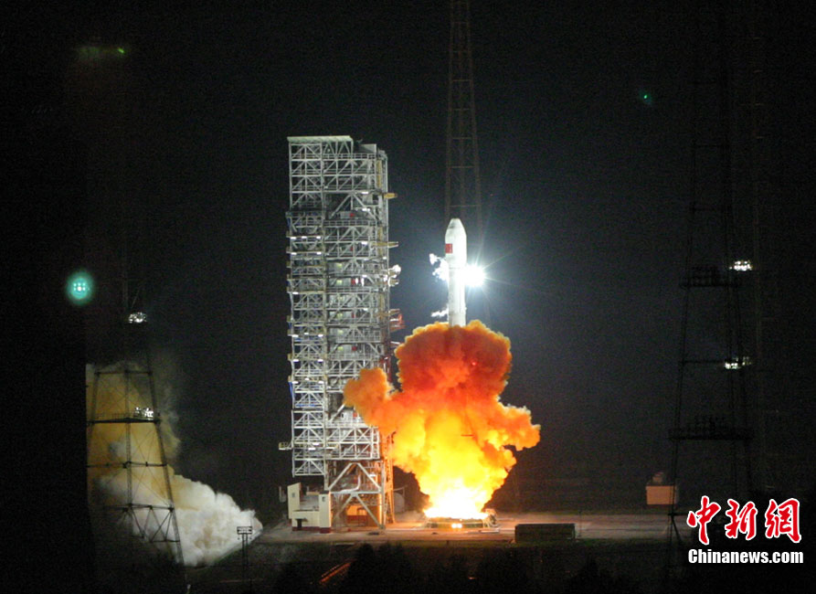
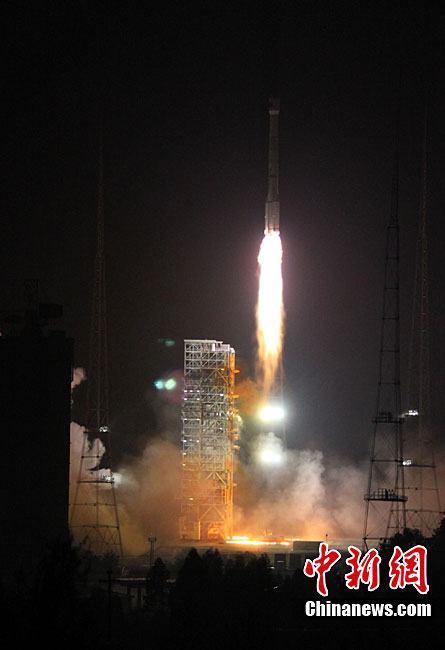
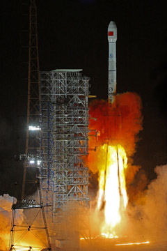
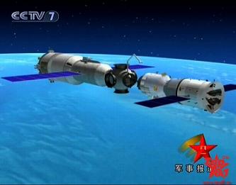
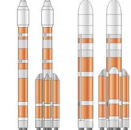
Following the three successful launches of the BeiDou-1 satellites in 2000 and 2003, China began to launch the second-generation BeiDou-2 satellites in 2007. The first BeiDou-2 navigation experimental satellite was successfully placed into orbit on Saturday 3 February 2007. A CZ-3A three-stage space launch vehicle carrying the satellite lifted off from Xichang Satellite Launch Centre (XSLC) at 16:28 GMT on 2 February (00:28 local time on 3 February). The satellite was separated from the launch vehicle about 24 minutes later. Data from the Xi'an Satellite Monitoring & Control Centre showed that the satellite had accurately entered its planned orbit.

The satellite was placed into the GEO, presumably to complement the three existing regional Beidou-1 geostationary satellites by occupying the open slots at Longitudes 58.75 and 160 degrees East. A second launch is expected within few weeks.


BeiDou-2 Launch: The first BeiDou-2 satellite was launched on 3 February 2007 from Xichang Satellite Launch Centre by a CZ-3A space launch vehicle
 
China launches its second Beidou-2 navigation satellite

BEIJING, April 15 (China Military News cited from Xinhua) — China successfully launched its second navigation satellite early Wednesday, as part of the country’s independent global satellite navigation system.

The carrier rocket, Long March 3C, blasted off from the Xichang Satellite Launch Center in southwest China’s Sichuan Province at 0:16 a.m..

An official with the National Engineering Center of Satellite Navigation told Xinhua, the successful launch of the geostationary Earth orbit satellite was of great importance as it was the second one of the country’s satellite navigation system independent from foreign technology.

The system, code named “COMPASS”, is a crucial part of the country’s space infrastructure for providing navigation and positioning services in transportation, meteorology, petroleum prospecting, forest fire monitoring, disaster forecast, telecommunications and public security among others. It can bring significant social and economic benefits, the official said.

The system can help clients know their location at any time and place with accurate longitude, latitude and altitude data, and will offer “safer” positioning, velocity, timing communications for authorized users.

Previous reports said China planed to complete its independent global satellite navigation system by launching about 30 more orbiters before 2015, with 10 navigation satellites into the space in 2009 and 2010. The current Compass system only provides regional navigation service within China and neighboring regions.

The second “Compass” satellite and its carrier rocket were respectively developed by the China Academy of Space Technology and the China Academy of Launch Vehicle Technology which are under the China Aerospace Science and Technology Corporation.

It is the 116th flight for the country’s Long March series of rockets.

China launched the first “Compass” navigation satellite into geostationary orbit in April 2007 to build up its own positioning system following the United States’ Global Positioning System (GPS), the Galileo Positioning System of Europe and Russia’s Global Navigation Satellite System (GLONASS)
 
The American said that, F-22A is subversive;and for the matches , in order to construct the effective air defense system,they to need to spend 300,000,000,000 US dollars.
   The American should understand that, “Beidou " and the trajectory, the cruise missile coordination has subversive, because US will not be able to find the safe place around, including aircraft carrier.That's not a question about money , but the ideas of local war now had all changed.
In the Korean War, about close combatthe in the mobile warfare , the night fighting, the circuitous war, the positional warfare time " zero knocks sticky candy ", the Chinese army always can hold the matches' weakness,which causes the United States military superiority equipment to display with difficulty.
  The judgment of Mao Zedong was very extremely accurately, he said:" The US they can attack the Chinese native place and they can throw the atomic bomb to china, but all about is decided in the North Korean battlefield ."The result was that, US got hurted in North Korea , they could not attack the Chinese native place .
.
  After a succession of lessons , US walk around with China, therefore US instead moved towards the hegemonism new crest.When US they thought they may run amuck once more the world, once more when they approaches to China, once nightmare once more appears. This time,US had made full preparation. After 20 years combating experiences and the technological development, the US belive that they are absolute superiority. But the Chinese has found the US's weakness once more.
On February 25, 1991, Iraqi " the fast runner " missile has hit in a Saudi Arabian Allah Birdseye ,Heline's United States military military compound, has created the United States military 28 people the loss which died, more than 100 people is injured. That also was the biggest casualties in the first Gulf War.China keen discovered the United States military's shortcoming, their overseas garrison relies on the base but only just the" patriot "can defensed them .Therefore China starts to develop " Assassin's mace "secretly .We developed long-distance attack strength. The US also discovered that they were facing the long-range guided missile threat, so airplanes, warships, submarines and the tank has nothing of their functions.Only theTMD final level defense was effetive .China often takes the exemplary role, the ballistic missile had already becomes the most powerful weapon to restrain the American .

In fact , the American threatened to destroy the space satellite had already becoming " belated action ". Various satellites were all in an outer space trashcan .The American managed the outer space for several dozens years, finally they found theyself has been installed.

The American developed military force, which is extremely like the master who trains the gong fu's highest level, he often receives selects of the stimulation then to be able to overstate, and China is the person who bumps into it .
  For example the book "Ultra Limits Fights", the model wihch is comes from the practice and goes to the practice .
Chinese military thought suffered the American's for several dozens years, but it's not a meaning that we disparaged US's .TheAmerican's strategy has the place which as soon as the person of high skill plans, for instance they wined victory without firing a shot and they destroyed former Soviet Union.US destroyed the Japanese economy by the exchange rate weapon,which plays also is the high degree of proficiency.All about these also are the successful practices of "the ultra limits fights."
For all the Peaceful amateurs,from this ,from now on,i poped that we should engage in introspection of the past successes and the defeats .
 
Last edited:
  The reporter learned from the first China Satellite Navigation Annual Academic Conference held on May 19 that China would build the Beidou Satellite Navigation System covering the whole world in 2020.

  The satellite navigation system is an embodiment of a nation’s comprehensive strength, core competitiveness and technological innovation ability. After more than 10 years of efforts of the Chinese space scientific research personnel, the Beidou Satellite Navigation Experiment System entered the stage of steady progress of the launch and networking as well as system building in 2000, making China become the third country possessing an independent satellite navigation system following the U.S. and Russia.

  Qi Faren, academician of the Chinese Academy of Engineering, introduced that China was developing the global satellite navigation system on its own following a “three-step” development strategy. Firstly, a small number of satellites in the geosynchronous orbit were involved to conduct experiments, so as to accumulate experience and expertise, cultivate talents and develop ground infrastructure equipment for the construction of the Beidou Satellite Navigation System. Secondly, the Beidou Satellite Navigation System covering China and the neighboring areas is to be built up by 2012. Thirdly, the global satellite navigation system consisting of 5 geostationary satellites and 30 non-geostationary satellites is to be built up by 2020 to ensure global coverage.

  With the successful application of the Beidou Satellite Navigation Experiment System which was completed in 2000 and put into operation in a multiple of fields of national economic construction and national security, the work for “step 1” has been accomplished. Currently, the development of the Beidou Satellite Navigation System is at the crucial stage of “step 2”.

  On January 17, 2010, the third Beidu navigation satellite was successfully sent to the predetermined orbit by the “Long March-3C” carrier rocket at the Xichang Satellite Launch Center, symbolizing another important step forward in the building of the Beidou Satellite Navigation System.

  By Zou Weirong

http://eng.chinamil.com.cn/news-channels/china-military-news/2010-05/20/content_4222569.htm
 
Spaceflight Now | Breaking News | China sends Beidou navigation satellite to orbit
China sends Beidou navigation satellite to orbit
Posted: June 2, 2010
China launched another satellite Wednesday toward an orbit more than 22,000 miles above Earth, marking another step in building the country's own space navigation system.

lm3c.jpg

The Long March 3C rocket lifts off from the Xichang space center. Credit: CALT

The Beidou satellite launched at 1553 GMT (11:53 a.m. EDT 2nd June) on a Long March 3C rocket from the Xichang space center in Sichuan province in southwestern China, where it was just before midnight.

Powered by three stages and two strap-on boosters, the 180-foot-tall rocket turned east from Xichang and deployed the Beidou navigation satellite into a geosynchronous transfer orbit, according to the China Academy of Launch Vehicle Technology.

Engines on the satellite will further raise its altitude in the next few weeks, and the craft will eventually slide into a parking slot 22,300 miles over the equator to cover the Asia-Pacific region.

The satellite is the fourth spacecraft to be launched in the second-generation Beidou constellation. Two previous satellites were placed in geosynchronous orbit, including the system's newest member launched in January. Another spacecraft is operating in an orbit about 13,000 miles above Earth.

China is developing the Beidou, or Compass, navigation system to provide its military and citizens an indigenous source of precise navigation information. The country currently relies on the U.S. Air Force's Global Positionining System network.

beidou.jpg

Diagram of the full Beidou satellite constellation. Credit: CASC

Experimental Beidou satellites began launching in 2000, and Chinese officials hope the system can provide full navigation and timing coverage of China and neighboring countries by 2012.

China will eventually launch 35 satellites to expand the system to global coverage by 2020. Most of the operational Beidou satellites will circle 13,000 miles above Earth. Five spacecraft will support the system from geosynchronous orbit.

The constellation is China's counterpart to the U.S. GPS system, Russia's Glonass navigation satellites and the Galileo network being developed by Europe.

China says Beidou services will be available at no charge to civilians with positioning accuracy of about 10 meters, or 33 feet. More precise navigation data will be given to Chinese government and military users.
 
http://www.nasaspaceflight.com/2010/06/china-launches-beidou-2-station-lunar-plans-outlined/
China launches BeiDou-2 – Station and 2010 Lunar plans outlined
June 2nd, 2010 by Rui C. Barbosa
China launched a new navigation satellite on Wednesday, using a CZ-3C Chang Zheng-3C (CZ3C-4/Y4) launch vehicle from the Xi Chang satellite Launch Center, in Sichuan Province. Launch took place at 15:53 UTC, as the new BeiDou-2 (Compass-G3) series continues to build the Compass constellation – joining three other satellites already orbit.
14871_single.jpg

BeiDou-2 Launch:
The constellation of satellites will eventually consist of 35 spacecraft, including 30 MEO birds with nine satellites for each orbit plane, along with five GSO spacecraft.

The satellites will transmit signals on frequencies 1195.14-1219.14MHz, 1256.52-1280.52MHz, 1559.05-1563.15MHz and 1587.69-1591.79MHz. Notably, some of the signals overlay the Galileo PRS band and the GPS M-code.
It is stated under International Telecommunications Union (ITU) policies, that the first country to start using a specific frequency is granted priority status, and later service providers transmitting on the same band must ensure that their broadcasts do not interfere with previously authorized signal.

The Compass Navigation Satellite System (CNSS) is China’s second-generation satellite navigation system capable of providing continuous, real-time passive 3D geo-spatial positioning and speed measurement.

The system will be initially used to provide high-accuracy positioning services for users in China and its neighboring regions, covering an area of about 120 degrees longitude in the Northern Hemisphere. The long-term goal is to develop a global navigation satellite network similar to the GPS and GLONASS.

Like its American and Russian counterparts, CNSS will have two kinds of services: a civilian service that will allow for an accuracy of 10 meters for the user’s position, 0.2 m/s on the user velocity and 50 nanoseconds in time accuracy; and the military and authorized user’s service, providing higher accuracies.

The first phase of the project will concentrate on the coverage of the Chinese territory, while the future role of the Compass constellation will aim for global coverage.
A31.jpg

The BeiDou-2 was developed in the basis of the DFH-3 satellite platform and has a lifespan of 8 years.

This was the fourth flight of the CZ-3C Chang Zheng-3C launch vehicle. The rocket was developed to fill the gap between the CZ-3A Chang Zheng-3A and the CZ-3B Chang Zheng-3B, having a payload capacity of 3,800 kg for GTO. The rocket is a three stage launch vehicle identical to the CZ-3B, while only using two strap-on boosters on its first stage.

With a liftoff mass of 345,000 kg, the first two stages – along with the two straps on boosters – use hypergolic (N2O4/UDMH) fuel, while the third stage uses cryogenic (LOX/LH2) fuel. The total length of the CZ-3A is 54.838 meters, with a diameter of 3.35 meters on the core stage and 3.00 meters on the third stage.

The first launch of the CZ-3C Chang Zheng-3C launch vehicle took place on April 25, 2008 when it orbited the first TL-1 Tian Lian-1 tracking and data relay satellite.

This was the 125th successful Chinese orbital launch and the 124th launch of a Chang Zheng launch vehicle.

This was also the 53rd successful orbital launch from the Xi Chang Satellite Launch Centre, which is situated in the Sichuan Province, south-western China and is the country’s launch site for geosynchronous orbital launches.

Equipped with two launch pads (LC2 and LC3), the centre has a dedicated railway and highway lead directly to the launch site. The Command and Control Centre is located seven kilometers south-west of the launch pad, providing flight and safety control during launch rehearsal and launch.

Other facilities on the Xi Chang Satellite Launch Centre are the Launch Control Centre, propellant fueling systems, communications systems for launch command, telephone and data communications for users, and support equipment for meteorological monitoring and forecasting.

The first launch from Xi Chang took place on January 29, 1984, when the CZ-3 Chang Zheng-3 (CZ3-1) was launched the Shiyan Weixing (14670 1984-008A) communications satellite into orbit.
A41.jpg

Chinese Space Station and Lunar ambitions:

China is also gearing up for two important missions: the launch of Chang’e-2 next October and the launch of TG-1 TianGong-1 space module at the beginning of next year. TiangGong-1 is expected to accomplish the country’s first space docking and is regarded as an essential step toward building a space station, according to Qi Faren, former chief designer of Shenzhou spaceships.

Weighing about 8,500 kg, TianGong-1 will be able to perform long-term autonomous operations, which will be an essential step toward building a space station.
A5.jpg

The unmanned Shenzhou-8 spacecraft will aim to achieve China’s first space docking, with docking maneuvers controlled from the ground. Later Shenzhou-9 and Shenzhou-10 – the two other spaceships to dock with Tiangong-1 – are set to carry a crew of two or three.

With the launch and docking of TG-1 and SZ-8, China is able developed one of the most sophisticated space technologies – as it requires precise controlling of two high-speed spacecraft which meet and dock in space, together with other technologies like replenishment of propellant, air, water and food as well as a regenerating life guarantee system for the space module.

TG-1 TianGong-1 is going to be launched by a modified CZ-2F Chang Zheng-2F launch vehicle sometimes referred as CZ-2F/G Chang Zheng-2F/G, that has 170 technological modifications, including 38 major ones.

Meanwhile, China is advancing on the development of the CZ-5 Chang Zheng-5 series of launch vehicle, with the building of a launch vehicle production base in the northern municipality of Tianjin. According to official sources, this development has a total investment of 10 billion yuan and covers an area of more than one million square meters.

The base will be capable of producing 12 launch vehicles a year. After the first phase of construction is completed in 2011, the base will be able to produce two launch vehicles. Earlier reports point to the first launch of the CZ-5, with a maximum payload capacity of up to 25,000 kg, in 2014.
A6.jpg

Recent news notes China’s second lunar probe will be ready to fly next October. According to Wu Yansheng, deputy general manger of China Aerospace Science and Technology Corporation (CASC) talking at the Global Lunar Conference held in Beijing, “…the development of the carrier rocket and the satellite is complete…” and the specialists “…have started to conduct tests on their performance.”

Chang’e-2, that starts Phase II of China lunar exploration, will orbit the Moon at 100 km altitude for collecting data for the soft-landing of Chang’e-3. The probe will be equipped with a high-resolution camera that is capable of spotting lunar surface features as small as three feet across. Chang’e-1, launched on October 24, 2007 only had a resolution of 120 meters.

Also involved with Phase II are the launches of Chang’e-3 and Chang’e-4, two probes that will land on the Moon. Starting on 2017, the Phase III will see the launch of Chang’e-5 and Chang’e-6, that will return samples from the lunar surface.
 
October 31st, 2010 by Rui C. Barbosa

China has launched the sixth satellite in their growing navigation system on Sunday, via the launch of their Long March 3C (Chang Zheng-3C) launch vehicle, carrying the BeiDou-2 Compass-G4 satellite. The launch of took place from the Xi Chang Satellite Launch Center, in Sichuan Province at 16:26UTC on October 31.

Chinese Launch:

China’s constellation of satellites for the navigation system will eventually consist of 35 vehicles, including 27 MEO satellites, 5 GSO satellites and 3 IGSO birds. The satellites will transmit signals on the: 1195.14-1219.14MHz, 1256.52-1280.52MHz, 1559.05-1563.15MHz and 1587.69-1591.79MHz, carrier frequencies.

The BeiDou-2 was developed in the basis of the DFH-3 satellite platform and is expected to have a lifespan of eight years.

The Compass Navigation Satellite System (CNSS) is China’s second-generation satellite navigation system capable of providing continuous, real-time passive 3D geo-spatial positioning and speed measurement.

See Also
Chinese Forum Section
60 Launch Vehicle Manuals (L2)
Click here to Join L2
The system will be initially used to provide high-accuracy positioning services for users in China and its neighboring regions, covering an area of about 120 degrees longitude in the Northern Hemisphere. The long-term goal is to develop a global navigation satellite network similar to the GPS and GLONASS.

Like the American and Russian counterparts, CNSS will have two levels of service, ranging from a civilian service which will allow for an accuracy of 10 meters in the user position, 0.2 m/s on the user velocity and 50 nanoseconds in time accuracy; and the military and authorized users service, providing higher accuracies.

The first phase of the project will involve coverage of the Chinese territory, with the second phase covering the entire globe.

Previous BeiDou satellites for the second-generation satellite navigation system were launched on April 13, 2007 ‘Compass-M1′ (31115 2007-011A); April 14, 2009 ‘Compass-G2′ (34779 2009-018A); January 16, 2010 ‘Compass-G1′ (36287 2010-001A); June 2 ‘Compass-G3′ (36590 2010-024A) and July 31, ‘Compass-I1′ (36828 2010-036A).

This was the sixth flight of the CZ-3C Chang Zheng-3C launch vehicle. The vehicle was developed to fill the gap between the CZ-3A Chang Zheng-3A and the CZ-3B Chang Zheng-3B, having a payload capacity of 3,800 kg for GTO. This is a three stage launch vehicle identical to the CZ-3B but only using two strap-on boosters on its first stage.

The development of the CZ-3C started in February 1999. The rocket has a liftoff mass of 345,000 kg. The first two stages and the two strap on boosters use hypergolic (N2O4/UDMH) fuel, while the third stage uses cryogenic LOX. The total length of the CZ-3A is 54.838 meters, with a diameter of 3.35 meters on the core stage and 3.00 meters on the third stage.

The first launch of the CZ-3C Chang Zheng-3C launch vehicle took place on April 25, 2008 when it orbited the first TL-1 Tian Lian-1 tracking and data relay satellite.

This was the 134th successful Chinese orbital launch, the 133rd launch of a Chang Zheng launch vehicle, the sixth launch from Xi Chang in 2010, the 12th orbital launch for China in 2010, establishing a new total launch record for a year.

The Xi Chang Satellite Launch Centre is situated in the Sichuan Province, south-western China and is the country’s launch site for geosynchronous orbital launches.

Equipped with two launch pads (LC2 and LC3), the centre has a dedicated railway and highway lead directly to the launch site. The Command and Control Centre is located seven kilometers south-west of the launch pad, providing flight and safety control during launch rehearsal and launch. Down range Tracking and Control stations of the launch center are located in Xi Chang City and Yibin City of Sichuan Province, and Guiyang City of Guizhou Province. Each of them houses tracking and measurement equipment for the powered phase of a launch vehicle flight.

Other facilities on the Xi Chang Satellite Launch Centre are the Launch Control Centre, propellant fuelling systems, communications systems for launch command, telephone and data communications for users, and support equipment for meteorological monitoring and forecasting.

During 1993-1994, Xi Chang underwent extensive modernization and expansion, in part due to the requirements of the CZ-3 launcher family and in part to meet commercial customer needs.

The first launch from Xi Chang took place at 12:25UTC on January 29, 1984, when the CZ-3 Chang Zheng-3 (CZ3-1) was launched the Shiyan Weixing (14670 1984-008A) communications satellite into orbit. The launch of the new BeiDou-2 satellite was the 52nd successful orbital launch from Xi Chang.

Before the end of the year China plans other launches as the launch of the FY-3B Feng Yun-3B meteorological satellite, on November 4, the launch of the ST-1B Shen Tong-1B / ZX-20 (2) ZhongXing-20 (2) military communications satellite, and another launch for the Compass navigation system with the launch of the second BeiDou-2 IGSO (Inclined GSO) satellite of the system.

Orignal Link:

Chinese Long March 3C launches with BeiDou-2 | NASASpaceFlight.com
 
The development of the CZ-3C started in February 1999. The rocket has a liftoff mass of 345,000 kg. The first two stages and the two strap on boosters use hypergolic (N2O4/UDMH) fuel, while the third stage uses cryogenic LOX. The total length of the CZ-3A is 54.838 meters, with a diameter of 3.35 meters on the core stage and 3.00 meters on the third stage.

Hope our LO/Kero ang LO/LH engine can enter service quickly. It is said that the YF-100 LO/Kero is almost mature and will be installed on CZ-2F/H in 2011 or 2012 before the first launch of CZ-5 in 2014.
 
China launches 6th positioning satellite - People's Daily Online

P201011011416502842323629.jpg

The sixth orbiter into space as part of its satellite navigation and positioning network, which is known as the Beidou, or Compass, system, is launched on the Long March-3C carrier rocket at Xichang Satellite Launch Center in Xichang, southwest China's Sichuan Province, Nov. 1, 2010. (Source: Chinanews.com.cn /photo: Wang Yulei)


China successfully launched its sixth orbiter which will form part of its indigenous satellite navigation and positioning network on Nov. 1.

A Long March-3C carrier rocket carrying the "Beidou," or Compass, navigation satellite took off at 12:26 a.m. on Nov.1 from the Xichang Satellite Launch Center in southwest China's Sichuan Province.

It will join five other satellites already in orbit to form a network, which will eventually consist of 35 satellites.

The network will provide satellite navigation services for Asia-Pacific regions by 2012 and global services by 2020.


The China Academy of Space Technology developed the satellite and the China Academy of Launch Vehicle Technology developed the carrier rocket.
P201011011421372932023962.jpg


P201011011421532528977121.jpg


P201011011422282876528045.jpg
 
Chinese Space Capabilities (Strictly)

The China National Space Administration (CNSA) is the national space agency of the People's Republic of China responsible for the national space program.

It is responsible for planning and development of space activities. CNSA and China Aerospace Corporation (CASC) assumed the authority over space development efforts previously held by the Ministry of Aerospace Industry.

CNSA was established as a government institution to develop and fulfill China's due international obligations, with the approval by the Eighth National People's Congress of China (NPC).

The Ninth NPC assigned CNSA as an internal structure of the Commission of Science, Technology and Industry for National Defense (COSTIND).

CNSA assumes the following main responsibilities: signing governmental agreements in the space area on behalf of organizations, inter-governmental scientific and technical exchanges; and also being in charge of the enforcement of national space policies and managing the national space science, technology and industry.

Up to now, China has signed governmental space cooperation agreements with Brazil, Chile, France, Germany, India, Italy, Pakistan, Russia, Ukraine, the United Kingdom, the United States and some other countries. Significant achievements have been scored in the bilateral and multilateral and technology exchanges and cooperation.
 

Latest posts

Back
Top Bottom