ghazi52
PDF THINK TANK: ANALYST

- Joined
- Mar 21, 2007
- Messages
- 101,785
- Reaction score
- 106
- Country

- Location

World Hydrography Day:
Understanding hydrography and enabling autonomous technologies
Hydrography is the science that measures and describes the physical features of the navigable portion of the Earth's surface and adjoining coastal areas. In addition, it supports nautical charting and the provisioning of tide, current and water level information for safe navigation of shipping, as well as marine conservation and also determining the limits of continental shelf.
Hydrography underpins almost every other activity associated with the sea, including, resource exploitation, environmental protection and management, national marine spatial data infrastructures, recreational boating, coastal zone management, tourism and marine science to name a few.
As per the Safety of Life at Sea (SOLAS) Convention, the Contracting Governments of SOLAS are required to provide and maintain Hydrographic Services and products. In the past few decades, the following important factors have emphasized the need for adequate hydrographic survey coverage and the production of nautical charts and publications as required by SOLAS; the advent of exceptionally deep draught VLCC ships, the need to protect the marine environment, changing maritime trade patterns, the growing importance of seabed resources and the U.N. Law of the Sea Convention affecting areas of national jurisdiction.
However, many charts which were adequate a decade ago, may now have to be recompiled using new survey data, collected to a higher degree of accuracy and with improved coverage. This deficiency may not be limited to sparsely surveyed waters of developing nations, but may also apply to the coastal waters of major industrial states.
The hydrographic data is collected by using various state of the art gadgets which include satellite positioning systems and different type of depth measuring systems.
These systems are integrated and mounted on sea and air platforms. However, based on various studies it has been concluded that in developed maritime countries, return on investment on hydrographic surveys is around 1:10 because of its contribution towards blue economy.
Hydrographic information is a national asset required by both, governments and private sectors. Hydrography underpins almost every activity associated with the sea.
Some of the important activities are: Development of port and associated infrastructure, Resource exploration and exploitation, Establishing of national maritime boundaries, Environmental protection and management, Integrated Coastal Zone Management (ICZM), Inland waterways management, Marine scientific research, Laying of seabed pipelines and communication cables and Tourism etc.
On 23 December 2003, the UNGA adopted Resolution on Oceans and Law of the Sea that dealt, in large part, with safety of navigation. In this resolution, the General Assembly welcomes the work of the International Hydrographic Organization (IHO) and Invites IHO and the International Maritime Organization (IMO) to proceed with endeavors of empowering more noteworthy international cooperation and coordination.
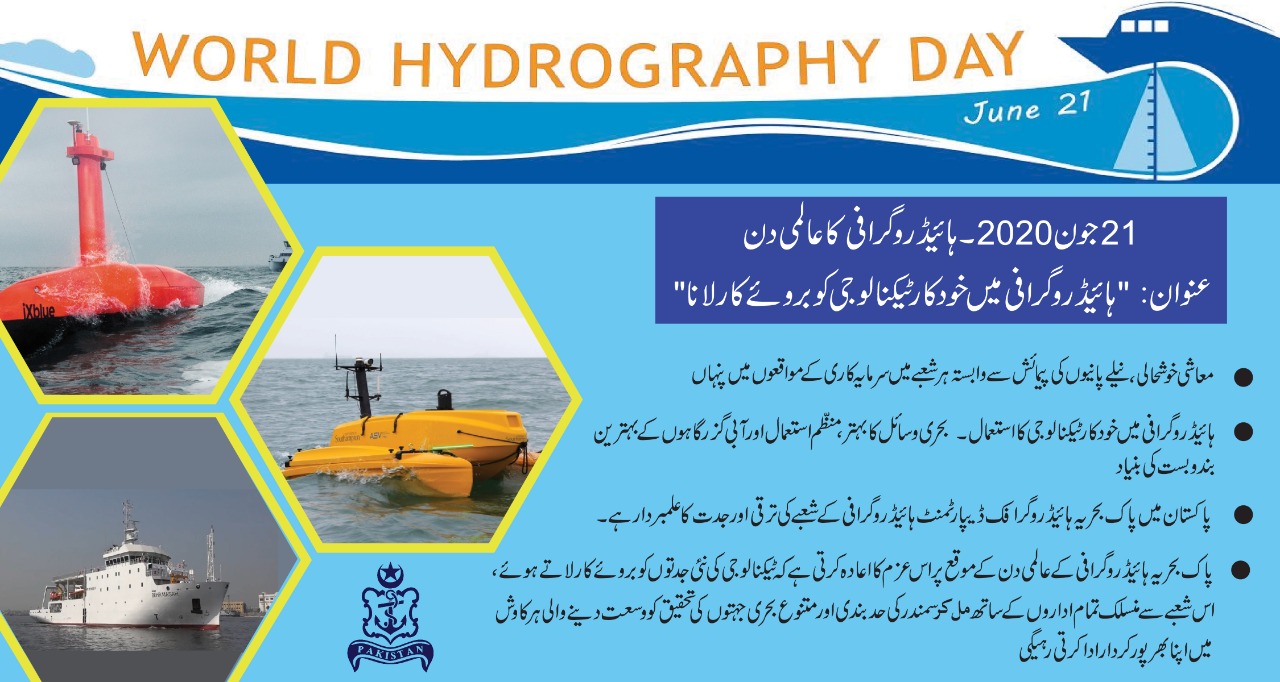
Thus, in this regard The International Hydrographic Organization (IHO) and its members celebrate World Hydrography Day every year on June 21.
This year’s theme, ‘hydrography enabling autonomous technologies’ is sparkling the focus on new developments that are revealing new data on our sea-beds. The running year theme, ‘Enabling Autonomous Technologies’ primarily underpins the use of innovation in attaining precision and accuracy in the field of hydrography.
For instance, the use of platforms such as autonomous surface vehicles (ASV), autonomous underwater vehicles (AUV) and LIDAR-equipped unmanned aerial vehicles (UAV), such as drones to conduct hydrographic surveys to attain precision.
The IHO suggests that in doing so hydrography will be providing a testing for the apt use of these technologies alongside increasing the coverage of the areas properly surveyed.
These initiatives thus will surely pave the way for the development of safe, secure and environmentally sound Maritime Autonomous Surface Ships (MASS) operations under the auspices of the IMO, which also require certified up-to-date hydrographic information in order to be implemented.
On behalf of Pakistan, Pakistan Navy Hydrographic Department (PNHD) is playing its prime role in fulfilling the international obligation of undertaking Hydrographic Surveys and production of nautical charts in a befitting manner.
The department was established in 1949 and represents Pakistan at all national and international hydrography related forums. It also represents Pakistan on relevant national and international hydrographic forums.
Apart from publishing traditional charts, PNHD Charting Center is also producing Electronic Navigation Charts (ENCs) as per international standards. These electronic charts play central role in today’s automated electronic navigation concept.
At the time of its inception, Pakistan has minimal capabilities to conduct the hydrographic research surveys yet the conversion of PNS ZULFQAR into survey vessel in 1948 is the glaring example of Pakistan Navy’s commitment to the maritime frontiers.
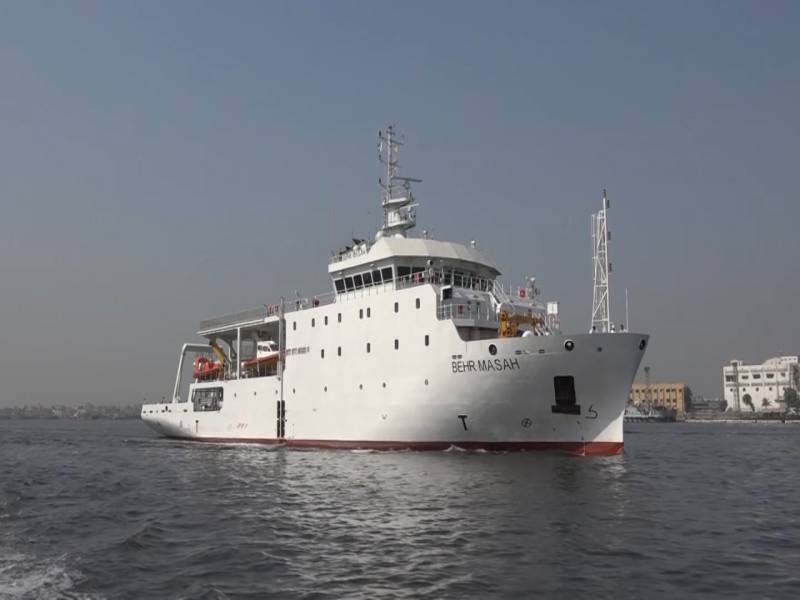
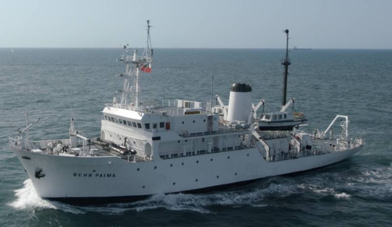
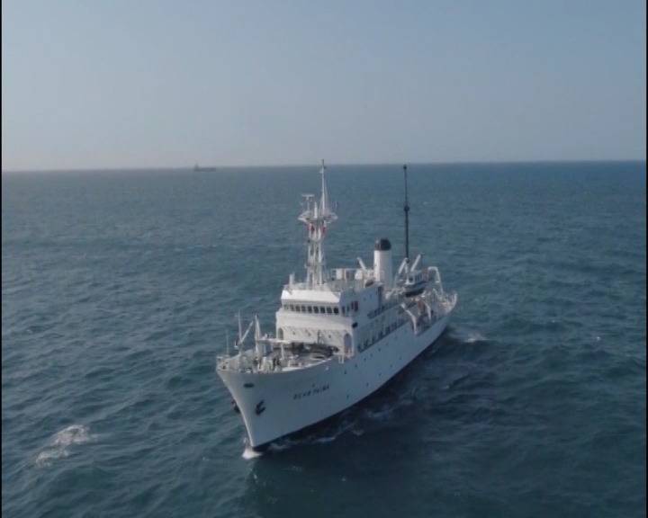
PNHD is mainly comprised of hydrographic survey ships, nautical chart production including distribution setup, national hydrographic data bank and a school to impart hydrographic training. PNHD has state of the art survey ships with one of the most modern survey platform of the region.
In addition to housing hydrography setup, this department is also shouldering the responsibility of Coordinator of NAVAREA-IX since 1976. NAVAREA IX consists of 16 countries of Gulf, Red Sea and North Arabian Sea region.
PNHD coordinates transmission of all information which is a safety concern for the vessels transiting in the area to give early information to the mariner in order to ensure safety of the ship/ craft.
The contributions of Pakistan Navy in the field of Hydrography are remarkable. For instance the expansion as well as the extension of the continental shelf is one such marvel to name. Pakistan has become the first country in North Indian Ocean to have successfully achieved extension in outer limits of continental shelf. Scientists from National Institute of Oceanography (NIO) and PNHD worked together for various phases of this claim.
As a result, an approximate area of 50000 Square Kms has been awarded which can be utilized for resource exploration. Furthermore, Systematic surveys of coastal areas and regular updation new series of charts covering all Pakistani waters. PNHD has conducted mapping of all the Pors t Muhammad Bin Qasim, Gwadar, Ormara and many other important areas along the coast.
Moreover, PNHD played a significant role in successful resolution of maritime boundaries with Iran and Oman.
Moreover, joint survey of Sir Creek by Pakistani and Indian hydrographic departments in 2007 was also carried out to support resolution of maritime boundary dispute amongst two countries.
In order to support various national level projects, PNHD has conducted various hydrographic surveys in different areas along the coast of Pakistan.
Apart from hydrographic surveys at sea, PNHD has conducted various inland surveys including surveys of dams for storage capacity in support of developing inland water ways. Seawater Intrusion (SWI) is a phenomenon which has significant effects on coastal ecosystem and infrastructure.
Considering the importance, PNHD is a member of this national level project for sharing relevant expert opinion with NIO.
To sum it up, being a stakeholder Pakistan Navy also celebrates the day with zeal and considers the day as an opportunity to highlight the significance and importance of its activities; which could include initiatives that support the safety of navigation, the protection of the marine environment, coastal zone management, marine spatial data infrastructures, defence and security, resource exploration, and all other components of the blue economy.
Understanding hydrography and enabling autonomous technologies
Hydrography is the science that measures and describes the physical features of the navigable portion of the Earth's surface and adjoining coastal areas. In addition, it supports nautical charting and the provisioning of tide, current and water level information for safe navigation of shipping, as well as marine conservation and also determining the limits of continental shelf.
Hydrography underpins almost every other activity associated with the sea, including, resource exploitation, environmental protection and management, national marine spatial data infrastructures, recreational boating, coastal zone management, tourism and marine science to name a few.
As per the Safety of Life at Sea (SOLAS) Convention, the Contracting Governments of SOLAS are required to provide and maintain Hydrographic Services and products. In the past few decades, the following important factors have emphasized the need for adequate hydrographic survey coverage and the production of nautical charts and publications as required by SOLAS; the advent of exceptionally deep draught VLCC ships, the need to protect the marine environment, changing maritime trade patterns, the growing importance of seabed resources and the U.N. Law of the Sea Convention affecting areas of national jurisdiction.
However, many charts which were adequate a decade ago, may now have to be recompiled using new survey data, collected to a higher degree of accuracy and with improved coverage. This deficiency may not be limited to sparsely surveyed waters of developing nations, but may also apply to the coastal waters of major industrial states.
The hydrographic data is collected by using various state of the art gadgets which include satellite positioning systems and different type of depth measuring systems.
These systems are integrated and mounted on sea and air platforms. However, based on various studies it has been concluded that in developed maritime countries, return on investment on hydrographic surveys is around 1:10 because of its contribution towards blue economy.
Hydrographic information is a national asset required by both, governments and private sectors. Hydrography underpins almost every activity associated with the sea.
Some of the important activities are: Development of port and associated infrastructure, Resource exploration and exploitation, Establishing of national maritime boundaries, Environmental protection and management, Integrated Coastal Zone Management (ICZM), Inland waterways management, Marine scientific research, Laying of seabed pipelines and communication cables and Tourism etc.
On 23 December 2003, the UNGA adopted Resolution on Oceans and Law of the Sea that dealt, in large part, with safety of navigation. In this resolution, the General Assembly welcomes the work of the International Hydrographic Organization (IHO) and Invites IHO and the International Maritime Organization (IMO) to proceed with endeavors of empowering more noteworthy international cooperation and coordination.
Thus, in this regard The International Hydrographic Organization (IHO) and its members celebrate World Hydrography Day every year on June 21.
This year’s theme, ‘hydrography enabling autonomous technologies’ is sparkling the focus on new developments that are revealing new data on our sea-beds. The running year theme, ‘Enabling Autonomous Technologies’ primarily underpins the use of innovation in attaining precision and accuracy in the field of hydrography.
For instance, the use of platforms such as autonomous surface vehicles (ASV), autonomous underwater vehicles (AUV) and LIDAR-equipped unmanned aerial vehicles (UAV), such as drones to conduct hydrographic surveys to attain precision.
The IHO suggests that in doing so hydrography will be providing a testing for the apt use of these technologies alongside increasing the coverage of the areas properly surveyed.
These initiatives thus will surely pave the way for the development of safe, secure and environmentally sound Maritime Autonomous Surface Ships (MASS) operations under the auspices of the IMO, which also require certified up-to-date hydrographic information in order to be implemented.
On behalf of Pakistan, Pakistan Navy Hydrographic Department (PNHD) is playing its prime role in fulfilling the international obligation of undertaking Hydrographic Surveys and production of nautical charts in a befitting manner.
The department was established in 1949 and represents Pakistan at all national and international hydrography related forums. It also represents Pakistan on relevant national and international hydrographic forums.
Apart from publishing traditional charts, PNHD Charting Center is also producing Electronic Navigation Charts (ENCs) as per international standards. These electronic charts play central role in today’s automated electronic navigation concept.
At the time of its inception, Pakistan has minimal capabilities to conduct the hydrographic research surveys yet the conversion of PNS ZULFQAR into survey vessel in 1948 is the glaring example of Pakistan Navy’s commitment to the maritime frontiers.
PNHD is mainly comprised of hydrographic survey ships, nautical chart production including distribution setup, national hydrographic data bank and a school to impart hydrographic training. PNHD has state of the art survey ships with one of the most modern survey platform of the region.
In addition to housing hydrography setup, this department is also shouldering the responsibility of Coordinator of NAVAREA-IX since 1976. NAVAREA IX consists of 16 countries of Gulf, Red Sea and North Arabian Sea region.
PNHD coordinates transmission of all information which is a safety concern for the vessels transiting in the area to give early information to the mariner in order to ensure safety of the ship/ craft.
The contributions of Pakistan Navy in the field of Hydrography are remarkable. For instance the expansion as well as the extension of the continental shelf is one such marvel to name. Pakistan has become the first country in North Indian Ocean to have successfully achieved extension in outer limits of continental shelf. Scientists from National Institute of Oceanography (NIO) and PNHD worked together for various phases of this claim.
As a result, an approximate area of 50000 Square Kms has been awarded which can be utilized for resource exploration. Furthermore, Systematic surveys of coastal areas and regular updation new series of charts covering all Pakistani waters. PNHD has conducted mapping of all the Pors t Muhammad Bin Qasim, Gwadar, Ormara and many other important areas along the coast.
Moreover, PNHD played a significant role in successful resolution of maritime boundaries with Iran and Oman.
Moreover, joint survey of Sir Creek by Pakistani and Indian hydrographic departments in 2007 was also carried out to support resolution of maritime boundary dispute amongst two countries.
In order to support various national level projects, PNHD has conducted various hydrographic surveys in different areas along the coast of Pakistan.
Apart from hydrographic surveys at sea, PNHD has conducted various inland surveys including surveys of dams for storage capacity in support of developing inland water ways. Seawater Intrusion (SWI) is a phenomenon which has significant effects on coastal ecosystem and infrastructure.
Considering the importance, PNHD is a member of this national level project for sharing relevant expert opinion with NIO.
To sum it up, being a stakeholder Pakistan Navy also celebrates the day with zeal and considers the day as an opportunity to highlight the significance and importance of its activities; which could include initiatives that support the safety of navigation, the protection of the marine environment, coastal zone management, marine spatial data infrastructures, defence and security, resource exploration, and all other components of the blue economy.