What's new

We are ready for our foes. A foe state is always a foe state.

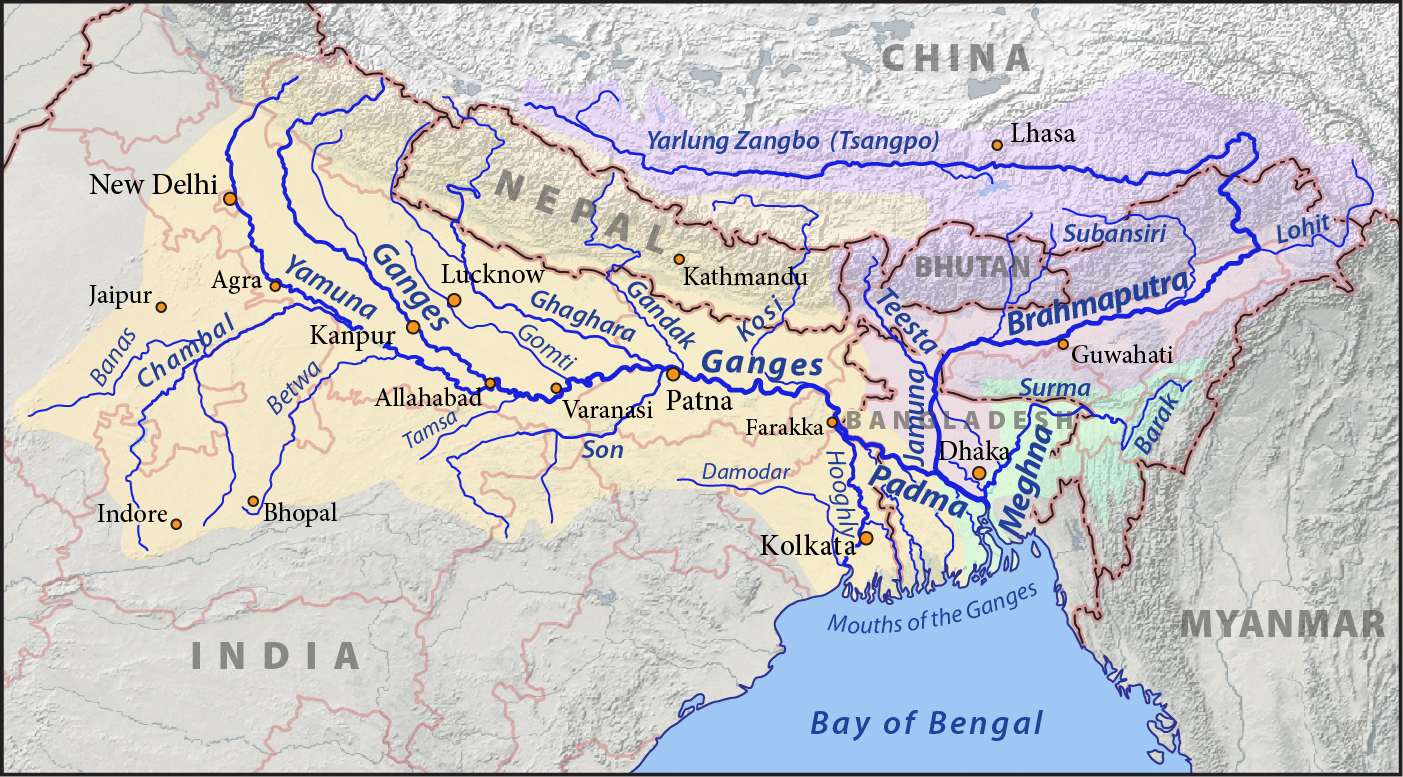
It is also worth pointing out that the Teesta has fluctuated wildly in the past, and diverting her waters is not rocket science. The diversion has to be done well before Jalpaiguri, somewhere in the Siliguri vicinity, to take the Korola along with it. Training the Brahmaputra to move north will be an enormous task, as it is massive by the time it reaches lower Assam. But it can be done, or it can be dammed.

Regarding Farakka, most chuckleheads don't realise that the original main channel of the Ganges, until Mughal times, was along the Hooghly; the Padma-Meghna belt got a lesser share, and depended more on the Brahmaputra.

The Hooghly went down to Tribeni and split into three, one channel going on straight, one going further west and one turning off east, while the main flow continued down to the Kidderpore Basin and turned off through Tolly's Nullah to the sea. That was, in fact, the main channel of the Ganges; the lower portion of the modern river was fed by the western branch curving back in.

The traces of the old Buri Ganga, or Tolly's Nullah can still be detected,although they are being covered up rapidly under the rapacious activity of builders, particularly in the southern Metro area, and after Garia. Soon, it will die out permanently.
 
It will ONLY cause Bangladesh problems, as there is already excess water in the Assam valley around the Brahmaputra. Second, much of the regeneration of water-flow is within the Arunachal hills, AND the Kameng and the Subansiri are both generated within Arunachal.
Bangladesh's annual internal renewable surface water is 105 km3 which is runoff from precipitation fall within only inside Bangladesh.Our annual water demand is 36 km3 mostly for agriculture.So if all external water stopped at border then we still have 3 times the water needed to maintain all requirement.So stop deluding yourself that anyone can blackmail Bangladesh over water.We have plenty of our own.You can study UN's water resource department AQUASTAT's report on Bangladesh.
http://www.fao.org/nr/water/aquastat/countries_regions/bgd/index.stm
 
You need to read geography of that area.Teesta is a small river originated in Sikkim highland and entered Bangladesh by bisecting narrow width of Siliguri corridor.

I can imagine that trying to work this out on a very large-scale map is misleading. As I mentioned, I lived on the banks of the Teesta for four years, used to walk to school frightened out of my wits with the raging monsoon Teesta just three feet away from the lip of the Bundh.

Yes, it originates in Sikkim and falls into the plains at Sevoke. That is where it is very easy to divert, not lower down; at Jalpaiguri, it is already unmanageable.

It does not quite bisect the Siliguri Corridor. That runs South-south-west to North-north-east, one compass point away from a south-west/north-east axis. The Teesta runs at right angles to this corridor. Training it along the edges of the foothills outside Siliguri, and letting it drop naturally through the Naxalbari sub-division into Dinajpur, the portion that was detached from Purnea to join up the northern and southern parts of west Bengal, is not a big deal.

There is some misunderstanding about the nature and size of the Siliguri Corridor. It is about 10 to 15 miles broad. Not huge, but not tiny either. If it were sought to be done, it can be done.

Its flow is natural from high upland towards lower plain in Bangladesh.

While river linking requires water diversion from lowland Brahmaputra valley to upland Siliguri corridor,then link that water channel to Ganges river.

I don't think that is possible. I agree.

Entire North -East is connected to mainland India by a single narrow road,now imagine creating a wide river like canal through this corridor with its entire length that to against gravity.

LOL.

It's a seventeen-mile wide corridor, if I remember correctly. We would drive past Siliguri and drive on for about fifteen or twenty minutes before the road started curving up.
Ganges-Brahmaputra-Meghna_basins.jpg

Bangladesh's annual internal renewable surface water is 105 km3 which is runoff from precipitation fall within only inside Bangladesh.Our annual water demand is 36 km3 mostly for agriculture.So if all external water stopped at border then we still have 3 times the water needed to maintain all requirement.So stop deluding yourself that anyone can blackmail Bangladesh over water.We have plenty of our own.You can study UN's water resource department AQUASTAT's report on Bangladesh.
http://www.fao.org/nr/water/aquastat/countries_regions/bgd/index.stm


Who talked about all that? Are you off your rocker? I was talking about the river-linking project, which I don't personally agree with, because of the ecological disasters that it will cause. But on a purely theoretical plane, parts of it are possible.
 
Bangladesh isn't a titanic. That by one breakthrough wid ice cold it will sink. U r just talking about reasons not facts. If u open ur gate half of India will be flooded with our southern point. Dn't think whole bd will be flooded.

I said china control the line of Bramaputra. every major river's mother is Baramaputra in ur country. If they stop the line. u have nothing to do anything . And internally we know how to tackle ur problem. It's simple channels with those rivers.. Making cannels to the land. Now if ur flow 100000000 sq water , that will nothing for us. But again saying with southern part of bd many Indian states will be under water at a time.

I am talking about a war with Bangladesh (that you have suggested), we can open the lockgates of our reservoirs and wash BD down to BoB, we won't need anything else. It can be done, we have dams on all 53-54 rivers entering BD from India. :P

And name those "every major river's" whose "mother is Baramaputra" in our country. :)
 
There is some misunderstanding about the nature and size of the Siliguri Corridor. It is about 10 to 15 miles broad. Not huge, but not tiny either. If it were sought to be done, it can be done
If the Siliguri corridor is large and convenient to bring up even the Brahmaputra flow uphill through the mountainous territory there, then, at least build some other physical infrastructures like roads, bridges, railway lines etc. that function properly.

Please find out a contour map of the Siliguri region and check if it is possible to cut through that region UPHILL to divert Brahmaputra water. India, is trying to blackmail BD as usual.Take the map to a civil engineer or to a surveyor and check the Brhmaputra matter with them.

But there are already roads, bridges, and railway lines. Function properly? What about them does not function properly? the entire rail traffic to the north-east goes through Siliguri.

I am mystified at the impression that Bangladeshis have about the Siliguri corridor. It is a growing town and there are major housing estates coming up around it; it is an entrepot for Darjeeling, Kalimpong, the Sikkim hills and Bhutan; and it is the major corridor for rail traffic.

Something wrong somewhere o_O

If the Siliguri corridor is large and convenient to bring up even the Brahmaputra flow uphill through the mountainous territory there, then, at least build some other physical infrastructures like roads, bridges, railway lines etc. that function properly.

Please find out a contour map of the Siliguri region and check if it is possible to cut through that region UPHILL to divert Brahmaputra water. India, is trying to blackmail BD as usual.Take the map to a civil engineer or to a surveyor and check the Brhmaputra matter with them.


LOL.

I don't have to; it's almost home ground for me. I spent more time there than anywhere else in Bengal, along with Calcutta, Purulia and Barrackpore.

Why should anyone cut through the region UPHILL? Channels will have to be cut at right angles to the slope, not against the slope. You should also see the alignment of the Brahmaputra; it curves left at a very sharp angle, but before that, it flows due west. Which means that anyone planning to divert it will have to cut through the high ground of the Alipur Duars. And that is not a long stretch, not at all.

A better question would be why on earth should this be done? What is the point?
 
Are you serious? I've lived there for four years. The Teesta flows right through. What difficulty is there in shifting other river courses, if such a thing were to be thought about?


Ei drishtibhongi-ta kon bhashae lekha?


Chin theke shudhu matro Brahmaputrer jol ashe. Onyo konotai na.


For instance? Which ones?

And mind your language.
A respect should be earned. I think you know that! Your buddy Rainman wants us to die in flood water? Can you explain more about it and his intension?
 
A respect should be earned. I think you know that! Your buddy Rainman wants us to die in flood water? Can you explain more about it and his intension?

I neither need nor want your respect.

You have been abusive, and beyond that, in your language, repeatedly. Please stop using foul language or you will face more rebukes.

My opinion of @Rain Man 's sardonic analysis is on the last line of #233. If you do not have the patience to read others' posts, or the comprehending ability to figure out what they mean, stay out of a discussion.
 
Who made u colonel? Dn't know the basic English ? If ur a military person thn my comments will be hard for u . However i am a military person too . In my comment i tune every word in 180 degree turn. I am saying. I am genius.. But if u can't understand that it ur prob. not mine.

Can't dispute that ! Nope

by the way , if you are a genius , then I am Einstein !
 

ফারাক্কা হোলস্কয়ার বা আন্তঃনদী সংযোগ প্রকল্পঃ হাতে মারবে না দাদা, ভাতে মারবে!
 
I don't need your suggestion too .You are one eyed and I don't need to stay out of disscution too.If you don't like better ignore my post. ..You don't own the site. Don't be an arrogant.
I neither need nor want your respect.

You have been abusive, and beyond that, in your language, repeatedly. Please stop using foul language or you will face more rebukes.

My opinion of @Rain Man 's sardonic analysis is on the last line of #233. If you do not have the patience to read others' posts, or the comprehending ability to figure out what they mean, stay out of a discussion.
 
A respect should be earned. I think you know that! Your buddy Rainman wants us to die in flood water? Can you explain more about it and his intension?

Your friend @Major d1 in this thread has declared war against my country, I am just exploring defensive options.
 
I don't need your suggestion too .You are one eyed and I don't need to stay out of disscution too.If you don't like better ignore my post. ..You don't own the site. Don't be an arrogant.

You will continue to get my suggestions. Get used to that. As for being one-eyed, I suggest that you correct the way you address other people. This kind of abusive talk will get you plenty of attention and plenty of negative ratings. And if I don't like your posts, I will spend more time and pay more attention to them.

Be warned.

Who owns the site is no concern of yours.
 
Why should anyone cut through the region UPHILL? Channels will have to be cut at right angles to the slope, not against the slope.

You right good english. But, I find many of your long posts are meaningless. The lines above prove my point. The Himalaya mountain longitudinally slopes down to the east. The Brahmaputra derives at the north of Kashmir, go straight to the east in parallel with the Himalaya before it changes course and flows down across the foot of eastern Himalaya, where the elevation is low (refer to your map).

Now, how do you think it is possible for Brahmaputra to flow in the upward direction to the Siliguri Corridor? By miracle from a divine power? Even, a divine power is not supposed to work against the law of gravity? So, I say contact a civil engineer with a topography survey map. The map you have sent is very good for talking in general matters. A contour map is what is required to discuss about technical matters.
 
Last edited:
You will continue to get my suggestions. Get used to that. As for being one-eyed, I suggest that you correct the way you address other people. This kind of abusive talk will get you plenty of attention and plenty of negative ratings. And if I don't like your posts, I will spend more time and pay more attention to them.

Be warned.

Who owns the site is no concern of yours.
Mad Joe, How old are you ? You better suggest yourself and stop threating people .That is utterly childish though! You are acting like Real Admiral and we are your subordinate lol .Take a chill pill and relax mate . You need some serious anger management.
 
Last edited:
Back
Top Bottom