DragonEmpire
BANNED

- Joined
- May 27, 2014
- Messages
- 217
- Reaction score
- -1
- Country

- Location

What should China do to the ICJ judges trying to play superpower politics way beyond their jurisdiction and academia qualifications?
Last edited:
Follow along with the video below to see how to install our site as a web app on your home screen.
Note: This feature may not be available in some browsers.


Reading at the poll options it just confirms china is a headache for the rest of peaceful Asia.
China should be officially kicked out of Asia.


Depend on what the ruling is. We still have the triumph card which is Itu Aba. Notice all the islands built within the surrounding area of Itu Aba's 200nm.
Then you need a maritime delimitation between the effect party. The arbitration has no legal basis to set maritime delimitation, only the states involve can. Either way, we do thought very carefully when we do something. This is a reminder not to fuk with us.The claims are overlapping in this case the island and 200 nm clause do not work !
As for you Vietnamese, you should be worrying more than we do in this case since most of the features Vietnam control fall within their 200nm zone. If the judge grant them 200nm right, you are fuk. LOLOL

As for you Vietnamese, you should be worrying more than we do in this case since most of the features Vietnam control fall within their 200nm zone. If the judge grant them 200nm right, you are fuk. LOLOL
Nobody believe in your bullshit lying.! Are you planning on giving up your occupied territory to the Phillipine. Answer in honesty. Why do you think your government make a statement immediately after us without joining the case? you are fuk because you know it! LOLOLOLIt's ok. We follow the international laws !!!
What should China do to the ICJ judges trying to play superpower politics way beyond their jurisdiction and academia qualifications?


Then you need a maritime delimitation between the effect party. The arbitration has no legal basis to set maritime delimitation, only the states involve can. Either way, we do thought very carefully when we do something. This is a reminder not to fuk with us.
RECLAMATION IN THE SOUTH CHINA SEA: LEGAL LOOPHOLES, PRACTICAL IMPACTS
Jay Batongbacal
February 18, 2015
China, Land Reclamation, Philippines, South China Sea
.
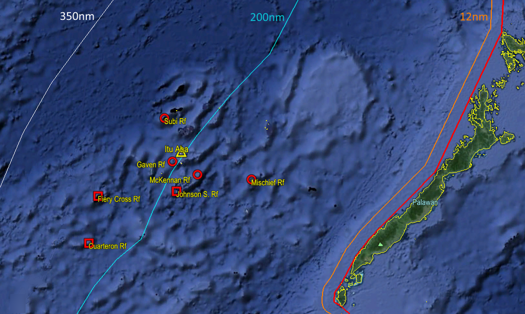
As if they were not complicated enough, the South China Sea disputes took a new turn in 2014 when China began massive land reclamation work in the region. The Philippines released photographs showing an unprecedented transformation of formerly pristine and submerged Johnson South Reef into high and dry white sand swarming with construction activity. Satellite photographs and ship tracking data by Jane’s confirmed that China’s reclamation activities extended to other features. By the end of the year, brand-new islands stood on Cuarteron, Fiery Cross, Gaven, Johnson South, and McKennan Reefs despite Philippine protests. Analysts believe Fiery Cross will be the first to host an airstrip and harbor. Most recently, Manila filed another protest over reported reclamation in Mischief Reef, located just 130 nm from the island province of Palawan. China has dismissed Philippine protests and sympathetic international reactions,initially describing the activities as intended for “improving the living and working conditions of those stationed on the islands,” arguing that the reclamation fell “within China’s sovereignty and are totally justifiable.”
There is little doubt that the China’s reclamation activities in the South China Sea are among its direct responses to the legal challenge launched by Manila. While the legal status of the contested features as described and presented in the arbitration case are not affected, their physical alteration effectively “tampers with the evidence”: the existence of the new islands will now cast doubt on whether the features were originally mere low-tide elevations or rocks above water at high tide. This makes future agreement over their nature resulting delimitations even more difficult to reach.
For China, the artificial islands also address its own perceptions of weakness in the strategic situation at sea and appear to be attempts to guarantee itself against an adverse ruling. It aims to re-capture the high ground and pressure littoral states in the region to recognize that Beijing’s claims cannot be easily dismissed nor its interests denied.
There is no special rule in international law that specifically prohibits any state from undertaking reclamation at sea; as with any other maritime activity, its legitimacy must principally be reckoned from its location vis-à-vis adjacent land territory. While it is undoubtedly within a state’s sovereignty to reclaim land within the 12 nautical mile territorial sea, beyond that, it must be considered whether it falls within the relevant rights and jurisdictions of states expressly recognized in UNCLOS. From 12 to 200 nautical miles, insofar as reclamation is part of the establishment and use of artificial islands, installations, and structures (stationary oil rigs may be considered as artificial islands), it is governed by UNCLOS articles on theExclusive Economic Zone and continental shelf.
Within these areas, coastal states may undertake reclamation as long as they give due notice and give due regard to the rights of all other States (UNCLOS Art. 60.3, 56.2, and 56.3). Such artificial islands, however, are clearly not entitled to maritime zones other than a 500 meter safety zone (Art. 60.5 and 60.8), and they cannot be established where they may interfere with international navigation (Art. 60.7). In the high seas beyond 200 nautical miles, all states have the freedom to establish artificial islands, installations and structures, and may not be expressly restricted by UNCLOS from reclamation activities in this respect.
To a large extent, China takes advantage of loopholes in the Philippines’ legal position. This is on account of the latter’s implicit assumption that all islands are individually entitled to only 12 nautical mile territorial seas, leaving only Palawan’s 200 nautical mile EEZ and continental shelf to reckon with in determining legal rights over Chinese-occupied features. It also exploits Manila’s concession that some of the Chinese positions are entitled at least to 12 nautical mile territorial sea zones.
Figure 1. China’s occupied features in the Spratly Islands region, including Itu Aba under Taiwan’s control, in relation to the Philippine island of Palawan.
Based on these premises, Cuarteron, Fiery Cross, and Gaven Reefs are located in the high seas outside the Philippine 200 nautical mile zone (in the absence of an extended continental shelf claim), making it difficult to assert that any exclusive rights are adversely affected. Johnson South and Kennan Reefs are within 200 nautical miles, but possibly located within 12 nautical miles of adjacent islands or rocks under Vietnamese possession; the determination of their legality will require at least prior detailed surveys and delimitation of maritime zones with Vietnam. Only Mischief Reef stands alone far enough away from any other features above water and well within 200 nautical miles from Palawan, such that reclamation thereon could be subject to a proper legal determination. However, this may require a separate case altogether, since the reported reclamation began after the pending case was initiated.
Apart from the limitations of the Philippine case as formulated, China is also relying on its trump card in the dispute: the status and potential maritime zones of Itu Aba, held by Taiwan. If Itu Aba were to generate a full 200 nautical mile EEZ (unlikely though it may be), the median line between it and Palawan would encompass all of the Chinese-occupied features including Mischief Reef. This clearly requires maritime delimitation which is outside the scope of the arbitration case.
These do not necessarily lead to the conclusion that China’s reclamation activities are beyond legal reproach. Even if China’s position were hypothetically accepted, it is still bound by the notice and due regard obligations in favor of other states noted above especially in the case of artificial islands, and is additionally obligated to refrain from acting in a manner that would jeopardize or hamper a final agreement resolving the dispute (Art. 74.3 and 83.3). This includes the obligation to not act unilaterally in a manner that will cause permanent damage to the marine environment, or to affect the rights of the other party in a permanent manner.
Considering the nature and impact of reclamation activities on coral reefs, China is also generally obliged under international environmental law and jurisprudence to give notice, undertake environmental impact assessments, and prevent or minimize significant trans-boundary environmental harm particularly in the context of shared resources. These general obligations apply even in cases where the activities and areas involved are within undisputed State territories. Notably, they may be invoked not only by the Philippines, but any one or all of the other littoral States whose coastal populations depend on the South China Sea.
Finally, even though it may be argued that all other littoral States have undertaken their own reclamation activities in the past, none have done so recently and in so massive a scale and on fully submerged reef areas, in the same manner as that being done by China. Such action clearly contravenes the spirit and commitments under the 2002 Declaration of Conduct of Parties that China has repeatedly invoked.
Thus, the legitimacy of China’s latest activities must be considered not in terms of reclamation per se, but in the context of the pre-existing dispute. By these standards, China’s actions contravene higher standards of fairness and due regard for the rights of other states; these international obligations govern the conduct of states pending the resolution of their maritime disputes. These abstract legalities also have long-term geopolitical impacts.
While China may regain the strategic high ground in the near-term with its rapid reclamation, ultimately it will lose the ability to handle the disputes in the way it prefers. Any remaining trust and confidence not only of the Philippines but all other littoral States will erode, alienating its immediate maritime neighborhood and reducing the chances of equitable bilateral settlements in the future. It will also catch the closer attention of other states formerly content with staying aloof or sitting on the sidelines, giving them more reason to strengthen their political, economic, even military bonds with the smaller states. And the fact that the new islands also have significant security implications for international navigation only highlights the shared interests of the international community at large, and therefore draws the focused attention of all external maritime powers. The stakes are not only higher, but also more diverse.
---------------
In other words, we didn't break no legality. The fact is simply we are smart to take advantage of the loophole and work our ways around it.
More info for you if you want to learn more about us vs them in this case.
Justice Carpio explains Itu Aba issue in the PH suit vs China
The Inbox – Mon, Feb 9, 2015
- Share

By Ellen T. Tordesillas
Last year, Itu Aba (also known as Taiping or Ligaw), the biggest feature in the Spratly group of islands being disputed by the Philippines, China, Vietnam, Malaysia, Brunei and Taiwan, figured in a controversy involving the appointment of the Solicitor General Francis Jardeleza to the Supreme Court.
Supreme Court Justice Lourdes Sereno opposed the appointment of Jardeleza to the High Court accusing him of treason when he omitted Itu Aba in the Memorial or memorandum filed before the United Nations Arbitral Tribunal in connection with the case filed by the Philippine questioning the legality of China’s nine-dashed line map which overreaches into the territory of the Philippines, Vietnam, Malaysia, Indonesia and Brunei.
Itu Aba is occupied by Taiwan, once part of China but now considers itself a sovereign state as Republic of China. The Philippines adopts a One-China policy which considers Taiwan a province of China.
Jardeleza was of the view that including Itu Aba in the Memorial would weaken the Philippine case because the island has a water source and can sustain human habitation and therefore entitled to maritime regimes. That would be outside the jurisdiction of the Arbitral Tribunal.
As a compromise by Jardeleza and the American lawyers handling the Philippine U.N. case, Itu Aba was included in the Memorial but it was not raised as a legal issue.
The High Court later cleared Jardeleza of the allegation of treason or disloyalty saying it was
“a legal strategy.”

Last Jan. 29, in a lecture at the Ateneo de Manila, Senior Associate Justice Antonio Carpio touched on Itu Aba.
He said the Philippines has a strong position in asserting ownership of Itu Aba: “Palawan has an area of 1,464,900 hectares, and a 650 KM coast facing the West Philippine Sea, while Itu Aba has an area of 46 hectares and a 1.4 KM coast. The relevant coast for Palawan is about 495 KM, while the relevant coast for Itu Aba is about 1 KM, or a ratio of 1:495 in favor of Palawan.
“The critical criterion is the length of the opposing coastlines in the overlapping maritime zones. Palawan is uniquely endowed by nature with an unusually long coastline – a total of more than 650 kilometers facing the West Philippines Sea. The combined coastline of all the Spratly Islands is minuscule compared to Palawan’s coastline.
“International law, international jurisprudence and nature itself have all combined to give the Philippines an impregnable position in this maritime dispute.”
If the U.N. Tribunal favors the Philippine government’s assertion that Itu Aba is not capable of human habitation or economic life of its own, Carpio said the tribunal will then declare that Palawan has a full 200 nautical mile Economic Exclusive Zone facing the West Philippine Sea.

“This means that all submerged features within this EEZ, like the Reed Bank and Malampaya, are subject to exclusive economic exploitation by the Philippines in terms of fisheries, oil and gas, and mineral resources,” he said.
Furthermore, he said, “If the Philippines has a full 200 NM EEZ in Palawan facing the West Philippine Sea, only the Philippines can create artificial islands on submerged areas or erect structures on LTEs (Low Tide Elevation) within its 200 NM EEZ. Artificial structures or reclamations made by other countries, namely by China and Vietnam, are illegal.”
On the other hand, if the tribunal rules that Itu Aba is capable of human habitation or economic life of its own, Carpio said the case as far as Itu Aba and Palawan are concerned becomes an issue of overlapping EEZs, outside of the tribunal’s jurisdiction in view of China’s reservation excluding boundary delimitation issues from compulsory arbitration.
“In such a case, the tribunal will then refuse to proceed further except to declare that Itu Aba generates its own EEZ and that there is a boundary delimitation issue on overlapping EEZs between Palawan and Itu Aba. The tribunal has no jurisdiction over such boundary delimitation issue because China has opted out of compulsory jurisdiction over boundary delimitation issues, “he said.
What then would be the recourse of the Philippines?
Carpio said, “The recourse of the Philippines is to file a compulsory conciliation case against China to determine the maritime boundary between Itu Aba and Palawan in view of the overlapping EEZs. Compulsory conciliation is the specific remedy granted by UNCLOS against a member state that has opted out of compulsory arbitration on maritime boundary delimitation. While the decision of the compulsory conciliation commission is not binding, it has strong persuasive effect because it is a statement of what the international law is with respect to the particular dispute.”
How will the compulsory conciliation commission resolve the overlap issue?

Carpio said, “The distance between Palawan and Itu Aba is 225 NM. Palawan has a 495 KM coastline facing Itu Aba while Itu Aba has only a 1 KM coastline facing Palawan. These opposing coastlines, when projected to seaward, create the overlapping zones.
“The ratio of the length of the relevant coasts is 1:495 in favor of Palawan, showing not only a substantial disparity, but an overwhelming disparity. “
Carpio further explained: “Applying the UNCLOS ‘equitable solution’ principle (no disproportionate allocation of the relevant maritime area between islands with unequal coastlines), Palawan will be allocated a full 200 NM EEZ facing Itu Aba, and Itu Aba will be given the balance of 25 NM as follows: 13 NM EEZ and 12 NM territorial sea facing Palawan. Itu Aba will also have an EEZ facing seaward up to where Vietnam’s EEZ ends.
“Since Palawan can also claim an ECS (Extended Continental Shelf) beyond its 200-NM EEZ, there is an overlap between Palawan’s ECS and Itu Aba’s EEZ. This overlap, called the ‘grey area,’ will be delimited by the compulsory conciliation commission also in accordance with the “equitable solution” principle applied in the delimitation of the overlapping EEZs. Itu Aba will be entitled only to the living resources in its 13-NM EEZ facing Palawan. The non-living resources in the seabed and subsoil within Itu Aba’s 13-NM EEZ facing Palawan will belong to Palawan’s ECS
“Itu Aba will have an EEZ seaward to the South China Sea up to where Vietnam’s EEZ ends. However, the non-living resources in the seabed and subsoil, up to 70 NM (median line between outer limits of Vietnam’s and the Philippines’ EEZs) measured from the outer limit of Palawan’s EEZ, excluding the territorial sea of Itu Aba, will form part of Palawan’s ECS.
“In short, the Philippines is entitled to the oil, gas, minerals and sedentary species in the grey area seaward of Itu Aba – the overlap between Itu Aba’s EEZ and Palawan’s ECS beyond the 200 NM EEZ of Palawan.
“This is the ‘condominium’” solution applied to the ‘grey area.’”
As for you Vietnamese, you should be worrying more than we do in this case since most of the features Vietnam control fall within their 200nm zone. If the judge grant them 200nm right, you are fuk. LOLOL
We are the protector of peace in Asia so it is our responsibility keep a safe passage zone in SCS.China have to obey rules of international laws. Reclamation such reefs which were robbed from Vietnam is useless for China to claim 200 nm EZZ based on UNCLOS.
Chinese invader is aggressor.

Itu Aba is administer by our province Taiwan, which all the rest of the world recognize in legal basis. End of story.
The law says you have 200 nm territorial boundary if the Islands are administered.
China never administered these islands nor there are any proofs that Chinese have inhibited them. Some Chinese fishermen used to take rest at those places.
Clear violation of UNCLOS. If you do not obey UNCLOS chinese logic of bullying and grabbing will be clear, but if you try to do the circus obeying UNCLOS Chinese will be fukced hard on this issue.


