What's new

China Space Military:Recon, Satcom, Navi, ASAT/BMD, Orbital Vehicle, SLV, etc.

Oh I'm sorry to embarrass yourself that China can't even used its own imagination to make its own picture instead of plagiarism.

And yeah showing that 3 seconds of Top Gun instead of showing your own pilots flying tells how bad your guys are.
those pictures are by journalists, they have no idea what it's suppose to look like, since America released certain pictures to its media, our media would have to copy yours, cause ours didn't reveal what it looks like.

No way would we reveal our weapon at this stage.

Also isn't having the weapon more important than a picture of what it suppose to look like? I mean that's my thinking, you can't throw a picture at a nation can you?
 
Any info on this,i qouted the important parts?
'Impossible' space engine may actually work, NASA test suggests - Yahoo News
''In 2012, however, a team of Chinese researchers built their own version of the system and found that it does indeed work, generating enough thrust to potentially power a satellite''

''The NASA scientists determined that the Cannae Drive produces 30 to 50 micronewtons of thrust — less than 0.1 percent of that measured by the Chinese team, Wired UK noted, but nevertheless suggesting that the technology works.''
 
those pictures are by journalists, they have no idea what it's suppose to look like, since America released certain pictures to its media, our media would have to copy yours, cause ours didn't reveal what it looks like.

No way would we reveal our weapon at this stage.

Also isn't having the weapon more important than a picture of what it suppose to look like? I mean that's my thinking, you can't throw a picture at a nation can you?

And yet our picture is based on what is real and can be thrown at.:-)
 
China just conducted a missile test.

Claimed by netizen because of similarity in NOTAM to be another WU-14, Pentagon's code name for a Chinese hypersonic glide vehicle (HGV)

132703rzhbzh9mhlkoa3bo.jpg


130505mooiu2a539r3bunv.jpg


130505bxgo88jry5bo5gxc.jpg


121651cmmgt8mmpggqjhvv.jpg
 
weibo - CCTV军事新闻

44b49710jw1ej6ddk9k0aj20qo0f0dg5.jpg


【我国成功发射遥感卫星二十号】 2014年8月 9 日13时 45分,我国在酒泉卫星发射中心用长征四号丙运载火箭,成功将遥感卫星二十号送入太空。遥感卫星二十号主要用于科学试验、国土资源普查、农作物估产及防灾 减灾等领域。这是长征系列运载火箭的第190次飞行

[China's successful launch on the 20th remote sensing satellite] at 13:45 on August 9th 2014, China's Jiuquan Satellite Launch Center successfully launch the 20th remote sensing satellite into space with Long March 4 rocket. 20th remote sensing satellite (YG-20) mainly used for scientific experiments, land resources survey, crop yield assessment, and disaster prevention and mitigation, and other area. This is the 190th flight of the Long March series of carrier rockets

163901lccbo5dbb5dn5ldd.jpg
 
Last edited:
China to test recoverable moon orbiter
Xinhua, August 10, 2014

China is preparing for the launch of an experimental recoverable moon orbiter, said the State Administration of Science, Technology and Industry for National Defence on Sunday.

The orbiter arrived in Xichang via air in southwest China's Sichuan Province on Sunday and then transported to the Xichang Satellite Launch Center, according to a statement from the administration.

The launch will take place before the end of this year, it said.

The plan is for the orbiter to be launched into lunar orbit and return to Earth at an escape velocity of 11.2 km per second.

The orbiter is one of the test models for China's new lunar probe Chang'e-5, which will be tasked with landing on the moon, collecting samples and returning to Earth.

The launch is aimed at testing the technologies that are vital for the success of Chang'e-5, the statement said.

China launched the Chang'e-3 lunar probe with its moon rover, Yutu, in late 2013. Chang'e-3 successfully landed on the moon and Yutu operated well until its control mechanism failed in January.

As the backup probe of Chang'e-3, Chang'e-4 will be adapted to verify technologies for Chang'e-5.

The more sophisticated Chang'e-5 mission, including unmanned sampling and returning, requires technological breakthroughs in moon surface takeoff, sampling encapsulation, rendezvous and docking in lunar orbit, as well as high-speed Earth reentry.

c03fd5535f5715050ed13b.jpg


163715rmq1axuagvq0qtx3.jpg
 
20140817125542584.jpg

「高分一號」拍攝的新疆昌吉州呼圖壁縣山谷「大地的『肌肉』」自然地理地貌圖像/中新社
Photo taken by GF-1 (Gaofen-1) High-resolution Imaging Satellite of Xinjiang Changji Hutubi County valley "of the earth's muscle", natural geographical landscape image / CNS
 
  本组图像由国防科工局重大专项工程中心和中国科学院遥感与数字地球研究所提供。

389041.jpg
 

大地的“肌肉”
 
新疆 昌吉州 呼图壁县 山谷

 
   图像上方的方块是农田,此时农作物尚未返青,地块呈现灰褐色。沉积岩层经流水侵蚀切割所形成的山脉,中间如灰白色“骨骼”状的东西方向连续山丘是坚硬的 岩层所残留的,而下方大片红色是由于山上的植物覆盖所致。图像正中自上而下的是山谷中的一条河流。(高分一号卫星-PMS多光谱相机 2014年4月20日观测,图像大小40公里x40公里,空间分辨率8米)


388987.jpg


大地在“倾听”
 
新疆吐鲁番鄯善县罗布泊镇


   “大耳朵”区域是典型的内陆湖泊逐年干涸后湖盆经风蚀所形成的雅丹地貌,是我国西部典型的荒漠景观。蓝色的人工水库和浅粉色的戈壁绿洲,为枯燥的黄褐色 的戈壁和沙漠增添了一笔鲜活的色彩。 (高分一号卫星-WFV多光谱相机 2013年10月9日观测,图像大小200公里x200公里,空间分辨率16米)


388991.jpg


大地的“年轮”
 
甘肃 酒泉市 阿克塞县 附近


  大地的“年轮”记录了历史的沧桑,这是内陆湖泊逐年干涸后留下的印记。多年之后,人类的活动唤醒了蕴藏丰富资源的大地,一条道路自左向右横穿整块区域。(高分一号卫星-PMS多光谱相机 2014年3月25日观测,图像大小40公里x40公里,空间分辨率8米)


388995.jpg


游弋在戈壁滩上的“水母”
 
甘肃 酒泉 敦煌市 附近


  不同类型和不同年代形成的戈壁滩,层次分明。扇状洪积物特别明显,白色区域是盐碱地,“水母”须是水流形成的冲积沟。(高分一号卫星-PMS多光谱相机 2013年8月2日观测,图像大小40公里x40公里,空间分辨率8米)


388999.jpg


湖中之“吻”
 
青海 海北州 青海湖畔 东北角


  中部灰白色部分为在风蚀作用下形成的流沙,下部白色部分为流水与风力共同形成的湖中沙坝。(高分一号卫星-PMS多光谱相机 2013年10月8日观测,图像大小40公里x40公里,空间分辨率8米)


389003.jpg


山河相间显“秋颜”
 
甘肃 庆阳市 正宁县 崇山峻岭


  亮红色部分与褐色部分层次分明,反映了不同类型的植被。图像中的白色线状部分是季节性河流形成的干涸沟谷。(高分一号卫星-PMS多光谱相机 2013年11月16日观测,图像大小40公里x40公里,空间分辨率8米)


389004.jpg


高原九曲十八弯
 
陕西延安黄陵县 洛河


   这是典型的黄土高原地貌,在长期流水侵蚀下地面被分割得非常破碎,形成沟壑交错其间的塬、墚、峁、川。平坦的墚顶和峁顶,一般进行农田耕作,呈现微暗的 粉红色。蜿蜒迩流的洛河贯穿整个区域。(高分一号卫星-PMS多光谱相机 2014年1月28日观测,图像大小40公里x40公里,空间分辨率8米)


389008.jpg


海滩利用展宏图
 
山东 东营 河口区 海滩


   排列整齐如“网格”的盐田和养殖场是海滩利用的主要形式之一。作为胜利油田所在地的东营海滩,则广泛分布着 “白点”状的油井。图像中上方的白色直线是调流坝。(高分一号卫星-PMS多光谱相机 2013年6月14日观测,图像大小40公里x40公里,空间分辨率8米)


389012.jpg


沙漠中的绿洲
 
新疆 和田 墨玉县


  图像黄色是沙漠,图像下方是高山,山上的河流自南向北流动,在山前形成绿洲(红色部分)。(高分一号卫星-WFV多光谱相机 2014年4月29日观测,图像大小200公里x200公里,空间分辨率16米)


389014.jpg


大地上的“红叶”
 
山西 长治市 附近


   图像中间如“红叶”般的区域山体植被覆盖较好,流水侵蚀导致的沟谷特征如同“红叶”的叶脉一般。图像左下方粉红色是农作物耕作区。图像右下方白色区域是 积雪覆盖。(高分一号卫星-WFV多光谱相机 2013年11月27日观测,图像大小200公里x200公里,空间分辨率16米)
 
2014年8月19日11时15分,我国在太原卫星发射中心用“长征四号乙”运载火箭,将“高分二号”卫星发射升空,卫星顺利进入预定轨道。这是我国重大科技专项高分辨率对地观测系统的第二颗卫星。此次任务还成功搭载发射了一个波兰卫星分配器和一颗波兰小卫星。

2014 August 19, 11:15 am,
China successfully launched Gaofen-2 & Heweliusz with CZ-4B
121507sajjacdztac8tia3.jpg

123600ev3yxxa0kyvq0xin.jpg

123559nmu2cmj52p5oq2om.jpg

BtErov7CUAESOVB.jpg

Gaofen-2, Earth observation satellite
Heweliusz_w_Dragonie.jpg

Heweliusz, Polish science satellite
 
1st LD-Writethru: China launches HD Earth observation satellite
Xinhua, August 19, 2014

China successfully launched its most advanced earth observation satellite, the Gaofen-2, on Tuesday.

The Gaofen-2, the country's second high-definition satellite in orbit, was launched from the Taiyuan Satellite Launch Center in north China's Shanxi Province at 11:15 a.m. Beijing Time.

It was boosted by a Long March-4B carrier rocket. A small satellite from Poland was also carried by the rocket, according to the State Administration of Science, Technology and Industry for National Defense(SASTIND).

It is China's most advanced high-definition Earth observation satellite, and is able to see a one-meter-long object from space in full color.

It will be used for geographic and resources surveillance, environment and climate change monitoring, precision agriculture, disaster relief and city planning.

The primary users of the satellite will be the Ministry of Land and Resources, the Ministry of Housing and Urban-Rural Development, the Ministry of Transport, and the State Forestry Administration, according to the SASTIND.

The Gaofen-2 is the second of seven satellites to be launched for China's indigenous high-definition observation project Gaofen before 2020. The project was initiated in May 2010.

Gaofen-1, the first satellite of the project, was launched in April 2013.

Gaofen-1 provides service for more than ten Chinese government departments including the ministries of land and resources, environmental protection and agriculture. It has also assisted China's search for the missing Malaysian airliner MH370 and played an important role in city development in Beijing, Hebei Province and Xinjiang Uygur Autonomous Region, according to the SASTIND.
 
Ham radio goes around the Moon

Full Moon 2010 – Credit Gregory H Revera

Towards the end of the year radio amateurs will have the opportunity to receive what must be the ultimate DX from a ham radio payload transmitting the data mode JT65B as it flies around the Moon.

Beijing plans to send a lunar orbiter around the Moon carrying a 14 kg battery powered payload known as 4M-LXS which was developed at LuxSpace. The amateur radio payload will transmit a JT65B signal on 145.990 MHz which can be decoded by radio amateurs using the free WJST software.

The orbiter is one of the test models for Beijing’s new lunar probe Chang’e-5, which will be tasked with landing on the moon, collecting samples and returning to Earth. The launch, planned for 4th quarter 2014, is aimed at testing the technologies that are vital for the success of Chang’e-5. The orbiter will be launched into Lunar Transfer Orbit (LTO) then will perform a flyby around the Moon and re-enter the Earth’s atmosphere after 9 days.
The orbiter arrived by air in Xichang, Sichuan on Sunday, August 10 and was then transported to the Xichang Satellite Launch Center.


Delivery convoy – Image credit Xinhua
 
yeah, comparing indian most advanced military sats with old chinese commercial sats. lol
even that you don't look any better. show me one indian high resolution satellite that has coverage area more that 10 km? lol current chinese commercial satellites with 1~2 m resolution are around 50 km swath and in colors, not black and white. they could easily achieve less than 1m if they use longer narrow lens, instead of wider angle. for what purpose? let indians goo goo gaga :lol:

the DF-2 they plan to launch is also around 50 km. yeah, i see they are widening the gap :lol:


lrrl.jpg

Excellent points.

catosat-1 2.5m .. 27 km swath
catosat-2a/2b .. 0.8m..9.6km swath
future catosat-3 ... 0.3m? .. 6km swath


just a few civilian chinese satelites that i know of..

cbers-2b launched 6 years ago with brazil .... 2.7m resolution, 27km swath
zy-3 ... 2.1m resolution, 51 km ground swath
Gaofen .. 1~2m resolution at around 40 ~ 50 km swath width
df-2 to be launched later this year capable of 0.8m res at 48km swath


the indians are not making any improvement at all generation after generation, other than sacrificing area coverage for boasting. indian sats has to go around earth multiple times to take shots to get same coverage compare other non-indian spy satellites. this is unacceptable for military purpose :lol:

27zy.jpg

lrrl.jpg


.

Excellent points once again.


203259ipp0capr6ycyha0p.gif


我国成功发射遥感卫星二十一号_图片频道_新华网


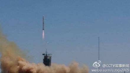
9月8日,搭载遥感卫 星二十一号的长征四号乙运载火箭点火升空。当日11时22分,我国在太原卫星发射中心用长征四号乙运载火箭,成功将遥感卫星二十一号发射升空,卫星顺利进 入预定轨道。此次任务还同时搭载发射了国防科技大学研制的天拓二号卫星。遥感卫星二十一号,主要用于科学试验、国土资源普查、农作物估产及防灾减灾等领 域。天拓二号卫星主要用于小卫星技术试验。这是长征系列运载火箭的第193次飞行。新华社记者 燕雁摄
China launches remote sensing satellite
2014-09-08 05:38:55 GMT2014-09-08 13:38:55(Beijing Time) Xinhua English

TAIYUAN, Sept. 8 (Xinhua) -- China successfully launched the Yaogan-21 remote sensing satellite into preset orbit at 11:22 a.m. on Monday Beijing Time (0322 GMT) from Taiyuan Satellite Launch Center.

Also launched in this mission was the Tiantuo-1 satellite, designed and built by the National University of Defense Technology and carried by Long March-4B rocket.

Yaogan-21 will be used for scientific experiments, natural resource survey, estimation of crop yield and disaster relief, while Tiantuo-1 was designed for smart satellite experiments.

The launch is the 193rd mission for the Long March rocket family.

126963631_14101535916191n.jpg


126963631_14101535917051n.jpg


126963631_14101535917471n.jpg


126963631_14101535917811n.jpg


126963631_14101535918091n.jpg


China returns to action with Yaogan Weixing-20 mission | NASASpaceFlight.com
August 9, 2014 by Rui C. Barbosa
Z21-350x139.jpg

Closing a four month gap since the previous orbital launch, China successfully launched the Yaogan Weixing-20 mission from the Jiuquan Satellite Launch Center. Launch took place on Saturday at 05:45 UTC from the 603 launch pad of the LC43 launch complex using a Long March-4C (Chang Zheng-4C) launch vehicle.
Chinese Launch:

The Yaogan Weixing-20 mission is composed of three satellites, with Chinese media referring to the new satellite as “a new remote sensing bird that will be used for scientific experiments, land survey, crop yield assessment, and disaster monitoring.”

As was the case in the last launches of the Yaogan Weixing series, Western analysts believe this class of satellites is being used for military purposes.

In particular this mission is similar to the Yaogan Weixing-9, Yaogan Weixing-16 and Yaogan Weixing-17, with three satellites flying in formation like a type of NOSS system.

Designed for locating and tracking foreign warships, the satellites will collect the optical and radio electronic signatures of the maritime vessels that will be used in conjunction with other information valuable for the Chinese maritime forces.

Yaogan-9 was launched on March 5, 2010, with Yaogan-16 bring was launched on November 25, 2012, and Yaogan-17 launched on September 1st, 2013.

This launch was the 202nd Chinese orbital launch and the 201st launch of the Long March launch vehicle family. It was also the 65th successful orbital launch from the Jiuquan Satellite launch Center.
 
Last edited:

Latest posts

Back
Top Bottom