What's new

China Space Military:Recon, Satcom, Navi, ASAT/BMD, Orbital Vehicle, SLV, etc.

Ok so what is your estimate?

How high resolution would it have?

What is the highest resolution of any Chinese satellite?
I don't know the military-level highest resolution of China satellite photo coz never mention it in Chinese news ... but the highest resolution of China commercial satellite photo <= 0.72m ... PLA using China spy satellite photo maybe better.
5-151012211422E0.jpg


090712200161b7a3d67ec47c4b.jpg
 
Beidou Navigation Satellite completes in-orbit test
CRI, November 26, 2015

A new round of testing has been conducted on the Beidou Satellite Navigational system toward allowing the Chinese system to begin offering real-time navigation and positioning services.

The tests have involved the high-tech atomic clocks on the satellites.

Beidou Chief Engineer Xie Jun says their testing will eventually give the Beidou system the ability to transmit real-time navigational information to its users.

"As we've seen from the testing results, the high-speed transmissions are working well. The advantage of high-speed transmission lies in the timely transmission of data from the satellite. The original low-speed transmissions delay the flow of data."

The latest edition to the Beidou Satellite Navigation System went into orbit at the end of September, giving the system 20 active satellites.

This now allows Beidou to cover most of the Asia-Pacific region.

When the system is fully-operational, it will cover the entire globe, and will be an alternative to the United States' GPS system, which is controlled by the US military.
 
I don't know the military-level highest resolution of China satellite photo coz never mention it in Chinese news ... but the highest resolution of China commercial satellite photo <= 0.72m ... PLA using China spy satellite photo maybe better.
View attachment 275146

View attachment 275147

China Space Flight on Twitter claims that the Satellite is a radar Satellite, with a ground resolution of 0.5m
 
China's GPS performing well after tests | Business Standard News

Three satellites launched this year for China's indigenous satellite navigation system are sending twice as many signals as their predecessors, said the system's designer after completing tests on the new units.

The 18th and 19th satellites for the Beidou Navigation Satellite System (BDS), which is being developed as an alternative to US-operated GPS, were sent into space on July 26, and the 20th satellite on September 30.

While they are less than half the weight of earlier generations, the new satellites' output is greater, matching the best around the world, said the China Academy of Space Technology in its latest newsletter.

After tests of their orbits and key technology, they are working as intended and in all weather, according to the academy, state-run Xinhua news agency reported today.

The 18th and 19th BDS satellites are the first that can communicate with each other, helping with distance measurements, said Wang Ping, chief engineer on the project.

China began to build the BDS in 1994, two decades after the United States developed GPS. China plans to complete a constellation of 35 satellites, achieving global coverage, by 2020.
 
Silent enter into GPS market – tests of Beidou Navigation Satellite System (BDS) completed
29 NOVEMBER 2015
  • Silent enter into GPS market – Tests of Beidou Navigation Satellite System (BDS) completed
After sending in this year three satellites under BDS navigation system China just has announced about positive results of operational tests.

China space industry is well known of its dynamic and pace of development. Impressive achievements made in a very short period of time and wide range of activities from commercial launch systems through manned space missions to scramjet spaceplanes are undoubtedly.

So it was quite surprising when China decided to join the Galileo program in 2004 and abandoning development of their Beidou Navigation system. But in the end again China decided to rely on her own solution, independently of foreign influences. Again it happened sooner than later.


History of developing Chinese navigation system is not as old as GPS or Glonass, but still seems longer than it is usually considered. First concept of national satellite navigation system was created in eighties – it was time in China, when huge change in way in thinking about economy and space program had begun. During these years first steps of commercializing of space industry took place, for example first Long March rockets designed especially for foreign customers were developed. It was sure, that sooner or later satellite navigation will be something common like satellite television.

In spite of fact that China had no experience in navigation systems (In USA establishing GPS was preceded by couple strictly Military navigation systems utilized by U.S. Navy) realistic deadline was set – term of first working system available for national customers was appointed in year 2000. Main founder of Chinese satellite navigation was Chen Fangyun, member of a standing committee of the Chinese Academy of Sciences.

First idea proposed in 1983 involved creating experimental system based on two satellites. On the basis of this assumption works continued until 1994 when Government officially ratified Beidou Satellite Positioning and Navigation system program. After six years China launched first satellites for experimental phase of program – BD-1A on 30 October 2000 and BD-1B on 20 December 2000.

Satellites were developed by China Academy of Space Technology (CAST) as medium weight (2200 kg) satellites with operational life at 5 years. Third satellite which was necessary for starting system (and also necessary as backup satellite) was launched in 2003. As launch vehicles in all three missions Long March 3A rocket was utilized, and launches were performing from Xichang Satellite Launch Center.

In 2004 China announced about starting cooperation under Galileo program (ESA navigation system) and further investing €230 million. It seemed clear, that Beidou will remain experimental system, or it will be limited only to military purposes with no intention of developing into civilian and commercial venture. Further rare missions with Beidou satellites were confirming such way of thinking; fourth satellite was launched on 2007 (BD-1D on atop of Long March 3A from Xichang Center).

In the meantime China gave to public information about technical possibilities of Beidou phase one – accuracy at 10 meters and speed at 0.2 m/s for open service. Comparing to existing Glonass, Beidou seemed to be promising system; remembering the fact that it was only in experimental phase.

Glonass was offering accuracy within range 5 to 10 meters and speed at 0.1 m/s. As far as GPS and Galileo were concerned – GPS standard accuracy was at 15 m and Galileo at 4 meters.

Also in 2007 first next generation Beidou satellite was launched (long March 3A rocket/Xichang Satellite Launch Center) – BD-2 M1. Still based on DFH-3 bus was able to remain operational for eight years (instead five in first generation). Seeing growing potential in their system, China decided to abandon Galileo in 2008 and develop Beidou as potential competitor on Asian market with objective to become worldwide navigation system. Since that moment, Beidou started phase 2.

In 2009 China started to extend constellation of Beidou satellites with BD-2 M (tested after first launch in 2007) and BD-2 G. In years 2009-2012 nine BD-2 M satellites were launched (Long March 3A in 2010-2011 and Long March 3B in 2012, all launches were performed from Xichang Satellite Launch Center) and six BD-2 G (Long March 3C, Xichang Satellite Launch Center). In 2012 old Beidou system was decommissioned and officially replaced with Beidou-2.

Beidou-2 will be based on constellation of 35 satellites and will be fully operational in 2020. At the moment second generation satellites are operating: BD-2 M and BD-2 G. Both types are designed to remain operational for eight years. M satellites weigh at 2200 kg and have power consumption at 3000 W. G type have weight at 4,600 kg and power consumption at 6800 W.

BD_2 G is equipped with two types of payload: RDSS (Radio Determination Satellite Service) which consists of high-power S band transponder, an L band low-noise amplifier, frequency generator, a large L/S band antenna, and a C band antenna. Second instrument is RNSS (Radio Navigation Satellite Service) which is combination different devices like: atomic clock, an L band transmitter, signal processor, transmitter antennas array, an L band uplink receiver, laser corner-cube reflector for orbit determination, and multilateration unit.

Difference between them is similar to difference between types of satellites in Galileo system. M type satellites are responsible for testing and validating signal send from G type satellites.

Beidou-2 is utilizing satellites injected into both GEO and intermediate Earth orbit. System was fully operational in Asia (covering area between longitude 55°E to 180°E and from latitude 55°S to 55°N) since 2012. Operating worldwide was started with launching in 2015 three satellites of third generation – BD-3 I (Long March 3B, Xichang Satellite Launch Center). Next five satellites from third generation called BD-3 G will be placed on GEO in following years.

Last class of satellites under Beidou-2 system is BD-3 M. It will be launched 27 satellites from this series; they are based on smaller bus called Navigation Satellite Bus. Weight of BD-3 M is at 1,014 kg with 280 kg of payload (RNSS) and power consumption at 1500 W. Satellites will be placed at Medium Earth orbit at altitude of 22000 km.

Beidou-2 will be available for civilian and military customers. Free of charge civilian version will offer 10 m accuracy, military version – 10 cm accuracy. For the moment in spite of Chinese Army, military version is utilized by Pakistan Armed Forces.

It is great success of Chinese space industry; firstly because of selling navigation system for foreign customer just after finishing operational testing. Second, because it means that both Glonass and GPS had lost competition – Pakistan is important customer for military industry.

Due the permanent conflict with India for Kashmir and less developed own space program, Pakistan is also promising partner in space ventures. China seems to have a pole position in Pakistan in that matter. Corporation under Pakistan space program with China started in early nineties when first Pakistan satellite Badr-I was launched from China (first Pakistan remote sensing satellite scheduled on 2018 will be probably also launched with Chinese launch vehicle).

Beidou-2 success seems to be confirmation of Chinese supremacy on Asian space military market. As far as civilian customers it is good to remind words of secretary-general of the Global Navigation Satellite System, Mr. Miao Qianjun from autumn 2015:

“The system will help create 200 billion yuan ($31.5 billion) in turnover for its customers this year,”

Today when 70% of China population is using smartphones equipped with satellite navigation receivers this market is very promising. Competition in Asian navigation system market is limited to Indian national navigation system operating only in India and Japanese Quasi-Zenith Satellite System (QZSS) is rather local upgraded GPS version providing wider service of data transfer than fully independent navigation system. It seems that China again stroke the home.
 
001YQVcwgy6VeHhQv8Kaa&690.jpg

2015 11 28
The long march seven is the final test before the first flight - modal test

baidu translation

“亚洲第一高塔”虽外表其貌不扬,内里却“高度”惊人。塔的内部中空,四周有回廊,特别是有火箭进驻时,场面蔚为壮观。
"Asia first tower" although it actually looks ugly in appearance but it has amazing "height", . The inside of the hollow tower, surrounded by corridors, especially with the rocket, spectacular scenes.

据介绍,全箭振动塔建筑面积为10230平方米,高93米,相当于30多层楼房的高度。长征五号、长征七号等新一代运载火箭各种飞行状态及子结构的模态试验,都可以在这里进行。

According to the introduction, the whole tower construction area of 10230 square meters, 93 meters high, equivalent to the height of the 30 storey building. The modal test of a new generation of carrier rocket, such as five and seven, and so on, can be carried out.

工作人员称,全箭振动塔是国内单层最高厂房,最大承载力为1500吨,支撑体系用钢量约1200吨,最大施工高度为90米,技术难度大,危险程度高,在国内尚无先例。

Staff said, the whole arrow vibration tower is the tallest building in the country, the maximum carrying capacity of 1500 tons, the supporting system with steel capacity of about 1200 tons, the maximum construction height of 90 meters, technical difficulty, high risk, there is no precedent in the country.

在这座高塔里,可以看到长征七号运载火箭的全貌。从下往上看,50多米高、近600吨重的火箭被16根吊下来的粗钢丝绳和底部的工装托住,有点像坐在“秋千”上。不过,火箭做模态试验时,振幅可不像荡秋千时那么大,甚至肉眼都不易觉察到。

In this tower, you can see the full picture of the long march seven launch vehicle. To look up from the bottom, more than 50 meters high and weighing nearly 600 tons of rocket is hanging down by 16 thick steel wire rope and the bottom of the tooling boosting, somewhat like sitting on the swing. However, when the Rockets do modal test, the amplitude is not as big as swing, and even the naked eye are not easy to perceive.

长征七号全箭模态试验模拟的是火箭从起飞到助推器分离前100多秒的真实飞行状态。在火箭身上,布有20多台激振器和500多个传感器,用于在试验时准确测得火箭横向、纵向及扭转振动的一系列试验数据。这些数据会定时传送给设计师,帮助他们验证和修正全箭结构动力学数学模型,进行稳定系统和动力系统设计,便于安装人员确定控制系统设备的安装位置等。

Long march seven full arrow modal test is a real state of 100 seconds flight before to the booster takeoff. In the rocket body, there are more than 20 vibration generators and more than 500 sensors, used to measure the lateral, longitudinal and torsional vibration of the rocket. These data will be transmitted to the designer to help them verify and correct the full arrow structure dynamics mathematical model, the stable system and power system design, to help determine the installation position of the control system.
 
View attachment 276119
2015 11 28
The long march seven is the final test before the first flight - modal test

baidu translation

“亚洲第一高塔”虽外表其貌不扬,内里却“高度”惊人。塔的内部中空,四周有回廊,特别是有火箭进驻时,场面蔚为壮观。
"Asia first tower" although it actually looks ugly in appearance but it has amazing "height", . The inside of the hollow tower, surrounded by corridors, especially with the rocket, spectacular scenes.

据介绍,全箭振动塔建筑面积为10230平方米,高93米,相当于30多层楼房的高度。长征五号、长征七号等新一代运载火箭各种飞行状态及子结构的模态试验,都可以在这里进行。

According to the introduction, the whole tower construction area of 10230 square meters, 93 meters high, equivalent to the height of the 30 storey building. The modal test of a new generation of carrier rocket, such as five and seven, and so on, can be carried out.

工作人员称,全箭振动塔是国内单层最高厂房,最大承载力为1500吨,支撑体系用钢量约1200吨,最大施工高度为90米,技术难度大,危险程度高,在国内尚无先例。

Staff said, the whole arrow vibration tower is the tallest building in the country, the maximum carrying capacity of 1500 tons, the supporting system with steel capacity of about 1200 tons, the maximum construction height of 90 meters, technical difficulty, high risk, there is no precedent in the country.

在这座高塔里,可以看到长征七号运载火箭的全貌。从下往上看,50多米高、近600吨重的火箭被16根吊下来的粗钢丝绳和底部的工装托住,有点像坐在“秋千”上。不过,火箭做模态试验时,振幅可不像荡秋千时那么大,甚至肉眼都不易觉察到。

In this tower, you can see the full picture of the long march seven launch vehicle. To look up from the bottom, more than 50 meters high and weighing nearly 600 tons of rocket is hanging down by 16 thick steel wire rope and the bottom of the tooling boosting, somewhat like sitting on the swing. However, when the Rockets do modal test, the amplitude is not as big as swing, and even the naked eye are not easy to perceive.

长征七号全箭模态试验模拟的是火箭从起飞到助推器分离前100多秒的真实飞行状态。在火箭身上,布有20多台激振器和500多个传感器,用于在试验时准确测得火箭横向、纵向及扭转振动的一系列试验数据。这些数据会定时传送给设计师,帮助他们验证和修正全箭结构动力学数学模型,进行稳定系统和动力系统设计,便于安装人员确定控制系统设备的安装位置等。

Long march seven full arrow modal test is a real state of 100 seconds flight before to the booster takeoff. In the rocket body, there are more than 20 vibration generators and more than 500 sensors, used to measure the lateral, longitudinal and torsional vibration of the rocket. These data will be transmitted to the designer to help them verify and correct the full arrow structure dynamics mathematical model, the stable system and power system design, to help determine the installation position of the control system.

Is CZ-7 going to be launch this year?
 
Apparently launch planned for December 9 around 16:45 UTC
A3550/15 - A TEMPORARY RESTRICTED AREA ESTABLISHED BOUNDED BY: N2722E10837-N2731E10743-N2715E10740-N2706E10833 BACK TO START. VERTICAL LIMITS:GND-UNL. GND - UNL, 09 DEC 16:39 2015 UNTIL 09 DEC 17:14 2015. CREATED: 03 DEC 07:13 2015

A3551/15 - A TEMPORARY RESTRICTED AREA ESTABLISHED BOUNDED BY: N2608E11429-N2615E11400-N2559E11356-N2552E11425 BACK TO START. VERTICAL LIMITS:GND-UNL. GND - UNL, 09 DEC 16:40 2015 UNTIL 09 DEC 17:29 2015. CREATED: 03 DEC 07:15 2015

NOTAMed area for Dec 4 aligned with TSLC
A3553/15 - A TEMPORARY RESTRICTED AREA ESTABLISHED BOUNDED BY: N404100E1015512-N401152E1045504-N394016E1044540-N395330E1031232-N40 2046E1001301-N405240E1002036 BACK TO START. VERTICAL LIMITS:GND-UNL. GND - UNL, 04 DEC 03:22 2015 UNTIL 04 DEC 04:13 2015. CREATED: 03 DEC 07:17 2015

Launch on December 4 from 11:22 to 12:13

1449132456999026.jpg


A3553/15 - A TEMPORARY RESTRICTED AREA ESTABLISHED BOUNDED BY:

N404100E1015512-N401152E1045504-N394016E1044540-N395330E1031232-N40

2046E1001301-N405240E1002036

BACK TO START. VERTICAL LIMITS:GND-UNL. GND - UNL,

04 DEC 03:22 2015 UNTIL 04 DEC 04:13 2015. CREATED: 03 DEC 07:17 2015
 
December 3, 2015
Junk-Eating Rocket Engine Could Clear Space Debris

The risks associated with space debris are rising. An efficient way to clear the skies of junk is desperately needed, and a team of Chinese engineers think they have the answer.

fiaIXlI.png


At 16:56 UTC on August 29, 2009, an Iridium communications satellite suddenly fell silent. In the hours that followed, the U.S. Space Surveillance Network reported that it was tracking two large clouds of debris—one from the Iridium and another from a defunct Russian military satellite called Cosmos 2251.

The debris was the result of a high-speed collision, the first time this is known to have happened between orbiting satellites. The impact created over 1,000 fragments greater than 10 centimeters in size and a much larger number of smaller pieces. This debris spread out around the planet in a deadly cloud.

Space debris is a pressing problem for Earth-orbiting spacecraft, and it could get significantly worse. When the density of space debris reaches a certain threshold, analysts predict that the fragmentation caused by collisions will trigger a runaway chain reaction that will fill the skies with ever increasing numbers of fragments. By some estimates that process could already be underway.

An obvious solution is to find a way to remove this debris. One option is to zap the larger pieces with a laser, vaporizing them in parts and causing the leftovers to deorbit. However, smaller pieces of debris cannot be dealt with in this way because they are difficult to locate and track.

Another option is send up a spacecraft capable of mopping up debris with a net or some other capture process. But these missions are severely limited by the amount of fuel they can carry.

Today, Lei Lan and pals from Tsinghua University in Beijing, China, propose a different solution. Their idea is to build an engine that converts space debris into propellant and so can maneuver itself almost indefinitely as it mops up the junk.

Their idea is simple in principle. At a high enough temperature, any element can be turned into a plasma of positive ions and electrons. This can be used as a propellant by accelerating it through an electric field.

The details are complex, however. In particular, the task of turning debris into a usable plasma is not entirely straightforward.

Lei and co focus their efforts on debris that is smaller than 10 centimeters in size, the stuff that laser ablation cannot tackle. Their idea is to capture the debris using a net and then transfer it to a ball mill. This is a rotating cylinder partially filled with abrasion-resistant balls that grind the debris into powder.

This powder is heated and fed into a system that separates positively charged ions from negatively charged electrons. The positive ions then pass into a powerful electric field that accelerates them to high energy, generating thrust as they are expelled as exhaust. The electrons are also expelled to keep the spacecraft electrically neutral.

Of course, the actual thrust this produces depends on the density of debris, the nature of the powder it produces, on the size of the positive ions, and so on. All this is hard to gauge.

And while the spacecraft does not need to carry propellant, it will need a source of power. Just where this will come from isn’t clear. Lei and co say that solar and nuclear power will suffice but do not address the serious concerns that any nuclear-powered spacecraft in Earth orbit will generate.

Nevertheless, the work provides food for thought. Space debris is an issue that looks likely to get significantly worse in the near future. It is an area where new ideas are desperately needed before the next big collision fills Earth’s orbits with even more debris.

Code:
http://www.technologyreview.com/view/544156/junk-eating-rocket-engine-could-clear-space-debris/?utm_campaign=socialsync&utm_medium=social-post&utm_source=twitter
 
Long March 3B lofts Chinasat-1C
December 9, 2015 by Rui C. Barbosa
Z2FSS1-350x139.jpg

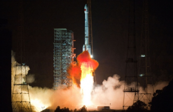
China launched the second of a new generation of tactical communications satellites. Zhongxing-1C – or Chinasat-1C – was launched at 16:46 UTC on December 9, 2015 – from the Xichang Satellite Launch Center. A Long March-3B/G2 rocket was used to loft the spacecraft uphill.


Chinese Launch:


Zhongxing-1C is possibly the second satellite of the second generation Fenghuo geostationary tactical military communication satellites based on the DFH-4 satellite platform.

China uses two types of satellites for secure military communications: the Fenghuo and the Shentong. The Fenghuo series is used for tactical military communications, providing secured digital data and voice communication to Chinese military forces.

The Chinese are currently operating the DFH-4 based Fenghuo-2 second-generation satellite, with the first of the series – the Zhongxing-1A (37804 2011-047A) – launched at 13:33 UTC on September 18th, 2011, by the Chang Zheng-3B (Y16) rocket.

See Also
The Shentong geostationary military communication satellites are operated by the Army and their aim is to provide secured voice and data communications services for ground users using Ku-band. Recently China launched the Zhongxing-2C (Chinasat-2C), the second satellite of the second generation of the Shentong series.

DFH-4 is the third generation communications satellite bus in China with high power, strong payload capacity and extended service life. It consists of a propulsion module, service modules and solar arrays. Its dimensions are 2360mm×2100mm×3600mm, with a liftoff mass of 5,200 kg. Solar Array Power is 10.5 kW (EOL) and payload power is 8 kW.

The platform can be equipped with C, Ku, Ka and L transponders. It uses a 3-axis stabilization mode and its station keeping precision is west/east ±0.05° and north/south ±0.05°. The Antenna Pointing Precision is <0.1°. Service life time in orbit is 15 years.

Launch vehicle and launch site:

To meet the demand of international satellite launch market, especially for high power and heavy communications satellites, the development of Long March-3B (Chang Zheng-3B) launch vehicle was started in 1986 on the basis of the fight proven technology of Long March launch vehicles.

Developed from the Chang Zheng-3A, the Chang Zheng-3B is at the moment the most powerful launch vehicle on the Chinese space launch fleet.

2015-09-12-163133-350x226.jpg
The CZ-3B features enlarged launch propellant tanks, improved computer systems, a larger 4.2 meter diameter payload fairing and the addition of four strap-on boosters in the core stage that provide additional help during the first phase of the launch.

The rocket is capable of launching a 11,200 kg satellite to a low Earth orbit or a 5,100 kg cargo to a geosynchronous transfer orbit.

The CZ-3B/G2 (Enhanced Version) launch vehicle was developed from the CZ-3B with a lengthened first core stage and strap-on boosters, increasing the GTO capacity up to 5,500kg.

On May 14, 2007, the first flight of CZ-3B/G2 was performed successfully, accurately sending the NigcomSat-1 into pre-determined orbit. With the GTO launch capability of 5,500kg, CZ-3B/G2 is dedicated for launching heavy GEO communications satellite.

The rocket structure also combines all sub-systems together and is composed of four strap-on boosters, a first stage, a second stage, a third stage and payload fairing.

2015-09-12-163210-350x233.jpg
The first two stages as well as the four strap-on boosters use hypergolic (N2O4/UDMH) fuel while the third stage uses cryogenic (LOX/LH2) fuel. The total length of the CZ-3B is 54.838 meters, with a diameter of 3.35 meters on the core stage and 3.00 meters on the third stage.

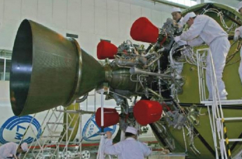
On the first stage, the CZ-3B uses a YF-21C engine with a 2,961.6 kN thrust and a specific impulse of 2,556.5 Ns/kg. The first stage diameter is 3.35 m and the stage length is 23.272 m.

Each strap-on booster is equipped with a YF-25 engine with a 740.4 kN thrust and a specific impulse of 2,556.2 Ns/kg. The strap-on booster diameter is 2.25 m and the strap-on booster length is 15.326 m.

2015-09-12-164401-350x230.jpg
The second stage is equipped with a YF-24E (main engine – 742 kN / 2,922.57 Ns/kg; four vernier engines – 47.1 kN / 2,910.5 Ns/kg each). The second stage diameter is 3.35 m and the stage length is 12.920 m.

The third stage is equipped with a YF-75 engine developing 167.17 kN and with a specific impulse of 4,295 Ns/kg. The fairing diameter of the CZ-3B is 4.00 meters and has a length of 9.56 meters.

The CZ-3B can also use the new Yuanzheng-1 (“Expedition-1″) upper stage that uses a small thrust 6.5 kN engine burning UDMH/N2O4 with specific impulse at 3,092 m/s. The upper stage is able to conduct two burns, having a 6.5 hour lifetime and is capable of achieving a variety of orbits. This upper stage was not used on this launch.

2015-11-03-014940-350x263.jpg
Typical flight sequence for the CZ-3B/G2 sees the launch pitching over 10 seconds after liftoff from the Xichang Satellite Launch Centre. Boosters shutdown 2 minutes and 7 seconds after liftoff, separation from the first stage one second latter. First stage shutdown takes place at 1 minutes 25 seconds into the flight.

Separation between the first and second stage takes place at 1 minute 26 seconds, following fairing separation at T+3 minutes 35 seconds. Stage 2 main engine shutdown occurs 326 seconds into the flight, following by the shutdown of the vernier engines 15 seconds later.

Separation between the second and the third stage and the ignition of the third stage takes place one second after the shutdown of the vernier engines of the second stage. The first burn of the third stage will lasts for 4 minutes and 44 seconds.

After the end of the first burn of the third stage follows a coast phase that ends at T+20 minutes and 58 seconds with the third stage initiating its second burn. This will have a 179 seconds duration. After the end of the second burn of the third stage, the launcher initiates a 20 second velocity adjustment maneuver. Spacecraft separation usually takes place at T+25 minutes 38 seconds after launch.

2015-07-25-130117-350x248.jpg
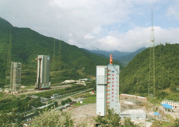
The Xichang Satellite Launch Centre is situated in the Sichuan Province, south-western China and is the country’s launch site for geosynchronous orbital launches.

Equipped with two launch pads (LC2 and LC3), the centre has a dedicated railway and highway lead directly to the launch site.

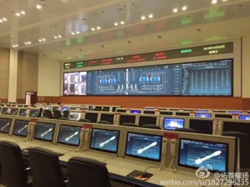
The Command and Control Centre is located seven kilometers south-west of the launch pad, providing flight and safety control during launch rehearsal and launch.

Other facilities on the Xichang Satellite Launch Centre are the Launch Control Centre, propellant fuelling systems, communications systems for launch command, telephone and data communications for users, and support equipment for meteorological monitoring and forecasting.

The first launch from Xichang took place at 12:25UTC on January 29, 1984, when the Chang Zheng-3 (Y1) was launched the Shiyan Weixing (14670 1984-008A) communications satellite into orbit.

Long March 3B lofts Chinasat-1C | NASASpaceFlight.com

2015年12月10日00时46分我国在西昌用CZ-3B火箭发射中星1C卫星—在线播放—优酷网,视频高清在线观看

Amateur launch video
 
我国成功发射“中星1C”卫星
2015年12月10日 02:05:01 来源: 新华网
128515022_14496973475591n.jpg

12月10日0时46分,搭载“中星1C”卫星的长征三号乙运载火箭升空。当日0时46分,我国在西昌卫星发射中心用长征三号乙运载火箭,成功将“中星1C”卫星送入太空预定转移轨道。 新华社记者薛玉斌摄

128515022_14496973999771n.jpg

12月10日0时46分,搭载“中星1C”卫星的长征三号乙运载火箭升空。当日0时46分,我国在西昌卫星发射中心用长征三号乙运载火箭,成功将“中星1C”卫星送入太空预定转移轨道。新华社记者薛玉斌摄

128515022_14496974702451n.jpg

12月10日0时46分,搭载“中星1C”卫星的长征三号乙运载火箭升空。当日0时46分,我国在西昌卫星发射中心用长征三号乙运载火箭,成功将“中星1C”卫星送入太空预定转移轨道。新华社记者薛玉斌摄

  新华网西昌12月10日电(薛玉斌、于柏华)12月10日0时46分,我国在西昌卫星发射中心用长征三号乙运载火箭,成功将“中星1C”卫星送入太空预定转移轨道。

  “中星1C”卫星是中国卫星通信集团有限公司所属的一颗通信广播卫星,由中国航天科技集团公司所属中国空间技术研究院研制。“中星1C”卫星可提供高质量的话音、数据、广播电视传输业务,将为我国通信广播事业提供更好的服务。

  用于这次发射的长征三号乙运载火箭由中国航天科技集团公司所属中国运载火箭技术研究院研制。这是长征系列运载火箭的第220次飞行。
Launch success official announcement (the name ZX -1C is confirmed)

A first object has been cataloged by USSTRATCOM (presumably the spacecraft)
2015-073A/41103 in 177 x 35816 km x 27.09°
 

Back
Top Bottom