anant_s
SENIOR MEMBER

- Joined
- Aug 21, 2012
- Messages
- 5,600
- Reaction score
- 92
- Country

- Location
Indian Regional Navigation Satellite System
The Indian Regional Navigational Satellite System (IRNSS) is a regional satellite navigation system owned by the Indian government. The system is being developed by Indian Space Research Organization (ISRO) .
IRNSS Introduction
IRNSS will be an independent and autonomous regional navigation system aiming a service area of about 1500 kilometers around India. The system will be under complete Indian control, with the space segment, ground segment and user receivers all being built in India.[1] It will have a range of applications including personal navigation.
IRNSS Architecture
IRNSS is planned to have 7 satellites complemented with the appropriate ground infrastructure.[2] As it is traditional in GNSS systems, the architecture is described next in three different segments: the space segment, the ground segment and the user segment.

IRNSS Architecture
There will be two kinds of services:[2]

IGP GRID to be used in IRNSS
Both services will be carried on L5 (1176.45 MHz) and S band (2492.08 MHz). The navigation signals would be transmitted in the S-band frequency (2–4 GHz) and broadcast through a phased array antenna to keep required coverage and signal strength.
The data structure for SPS and PS is under study; it is being planned to take advantage of the fact that the number of satellites is reduced -7 instead of the 30 used in other constellations- to broadcast ionospheric corrections for a grid of 80 points to provide service to single frequency users. The clock, ephemeris, almanac data of the 7 IRNSS satellites will be transmitted with the same accuracy as in legacy GPS, GLONASS & Galileo.[4]
The Performances expected for the IRNSS system are: Position accuracy around 20 m over the Indian Ocean Region (1500 km around India) and less than 10 m accuracy over India and GSO adjacent countries.
IRNSS Development
The Indian government approved the project in May 2006, with the intention of the system to be completed and implemented by 2015.
The first satellite of the proposed constellation was successfully launched on the 1st of July 2013[5]. It is IRNSS-1A one of the three Geosynchronous satellites that will is compose the entire constellation[6]. Despite the first launch was executed slightly later than the planned, at that time India has announced the deadline of 2015-2016 to launch the remaining six satellites[7]. As in the first launch the forthcoming will place in orbit only one satellite at a time. For that it is scheduled regular launches in every six months[8]. As of 18 July 2013 the Indian Space Research Organisation (ISRO) announced that the satellite successfully reached its defined inclined geosynchronous orbit and that the verification tests would start one week after. Before that, in 23 July the German Aerospace Center was able to receive a signal transmitted in the L5 band from the IRSNSS-1A satellite. From the analysis of the received signal researchers from German Aerospace Center concluded that the signal structure is consistent with what was announced as IRNSS Signal Plan by ISRO[9]. On April 4, 2014, India’s Indian Space Research Organisation (ISRO) successfully launched its second navigation satellite IRNSS-1B abord a Polar Satellite Launch Vehicle (PSLV) rocket[10] and on April 23 the satellite reached its intended orbital location and is operating normally[11].
IRNSS - Navipedia


http://www.oosa.unvienna.org/pdf/icg/2008/expert/2-3.pdf
IRNSS Images


The Indian Regional Navigational Satellite System (IRNSS) is a regional satellite navigation system owned by the Indian government. The system is being developed by Indian Space Research Organization (ISRO) .
IRNSS Introduction
IRNSS will be an independent and autonomous regional navigation system aiming a service area of about 1500 kilometers around India. The system will be under complete Indian control, with the space segment, ground segment and user receivers all being built in India.[1] It will have a range of applications including personal navigation.
IRNSS Architecture
IRNSS is planned to have 7 satellites complemented with the appropriate ground infrastructure.[2] As it is traditional in GNSS systems, the architecture is described next in three different segments: the space segment, the ground segment and the user segment.
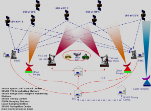
- The IRNSS Space Segment: 3 of the 7 satellites are geostationary orbit (GEOs) and they will be located at 34º East, 83º East and 131.5º East longitude.[3] There will be 4 geostationary satellites (GSO) in orbits of 24,000 km apogee and 250 km perigee inclined at 29 degrees. Two of the GSOs will cross the equator at 55º East and two at 111º East. The life span of the GEOs is 9.5 years and 11 years in the case of the GSOs.[2] The Constellation Design Considerations have been mainly:[3]
- Minimizing the Maximum DOP
- Minimum number of satellites
- Orbital slots for India for a continuous visibility with the control stations

IRNSS Architecture
- The IRNSS Ground Segment will consist of:[3]
- IRNSS Space Craft Control Centre (SCC)
- IRNSS Navigation Centre (INC)
- IRNSS TTC & Uplinking Stations (IRTTC)
- IRNSS Range and Integrity Monitoring Stations (IRIMS)
- IRNSS Timing Centre (IRNWT)
- IRNSS CDMA Ranging Stations (IRCDR)
- Laser Ranging Station (ILRS)
- Data Communication Network (IRDCN)
- The IRNSS User segment: the IRNSS user segment is made of the IRNSS receivers. They will be dual-frequency receivers or single frequency with capability to receive ionospheric correction. They will be able to receive and process navigation data from other GNSS constellations and the seven IRNSS satellites will be continuously tracked by the user receiver. The user receiver will have a minimum gain G/T of -27 dB/K.[3]
There will be two kinds of services:[2]
- Special Positioning Service (SPS)
- Precision Service (PS)

IGP GRID to be used in IRNSS
Both services will be carried on L5 (1176.45 MHz) and S band (2492.08 MHz). The navigation signals would be transmitted in the S-band frequency (2–4 GHz) and broadcast through a phased array antenna to keep required coverage and signal strength.
The data structure for SPS and PS is under study; it is being planned to take advantage of the fact that the number of satellites is reduced -7 instead of the 30 used in other constellations- to broadcast ionospheric corrections for a grid of 80 points to provide service to single frequency users. The clock, ephemeris, almanac data of the 7 IRNSS satellites will be transmitted with the same accuracy as in legacy GPS, GLONASS & Galileo.[4]
The Performances expected for the IRNSS system are: Position accuracy around 20 m over the Indian Ocean Region (1500 km around India) and less than 10 m accuracy over India and GSO adjacent countries.
IRNSS Development
The Indian government approved the project in May 2006, with the intention of the system to be completed and implemented by 2015.
The first satellite of the proposed constellation was successfully launched on the 1st of July 2013[5]. It is IRNSS-1A one of the three Geosynchronous satellites that will is compose the entire constellation[6]. Despite the first launch was executed slightly later than the planned, at that time India has announced the deadline of 2015-2016 to launch the remaining six satellites[7]. As in the first launch the forthcoming will place in orbit only one satellite at a time. For that it is scheduled regular launches in every six months[8]. As of 18 July 2013 the Indian Space Research Organisation (ISRO) announced that the satellite successfully reached its defined inclined geosynchronous orbit and that the verification tests would start one week after. Before that, in 23 July the German Aerospace Center was able to receive a signal transmitted in the L5 band from the IRSNSS-1A satellite. From the analysis of the received signal researchers from German Aerospace Center concluded that the signal structure is consistent with what was announced as IRNSS Signal Plan by ISRO[9]. On April 4, 2014, India’s Indian Space Research Organisation (ISRO) successfully launched its second navigation satellite IRNSS-1B abord a Polar Satellite Launch Vehicle (PSLV) rocket[10] and on April 23 the satellite reached its intended orbital location and is operating normally[11].
IRNSS - Navipedia
http://www.oosa.unvienna.org/pdf/icg/2008/expert/2-3.pdf
IRNSS Images